215354 Preisdatenbank Los(e) gefunden, die Ihrer Suche entsprechen
215354 Lose gefunden, die zu Ihrer Suche passen. Abonnieren Sie die Preisdatenbank, um sofortigen Zugriff auf alle Dienstleistungen der Preisdatenbank zu haben.
Preisdatenbank abonnieren- Liste
- Galerie
-
215354 Los(e)/Seite


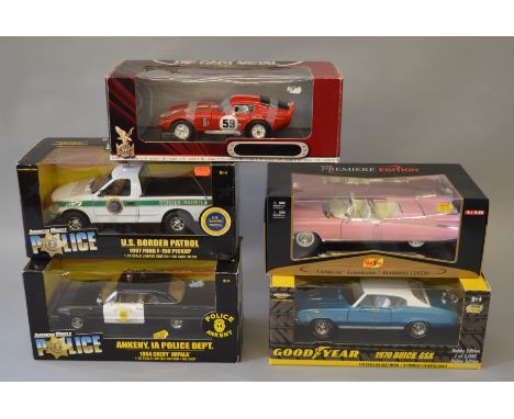
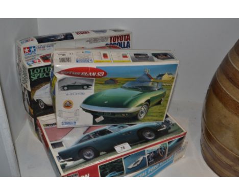
Los 504
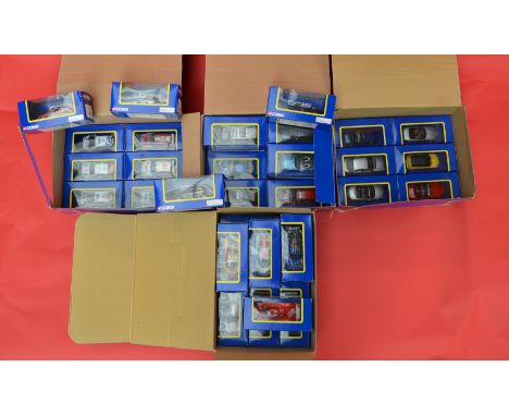
Five 1:18 scale diecast models, all American vehicles:ERTL American Muscle 1964 Chevy Impala Ankeny IA Police Dept; ERTL American Muscle 1997 Ford F-150 Pick-Up US Border Patrol; ERTL American Muscle 1970 Buick GSX; Maisto Cadillac Eldorado Biarritz 1959; Road Signature 1965 Shelby Cobra Daytona Coupe. Overall appear E, boxed. (5)
Los 598
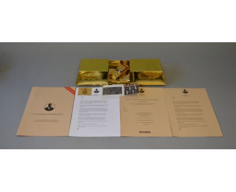
Corgi Premiums: James Bond 'Definitive Collection' Golden Opportunity. 24ct gold-plated 1:36 scale Aston Martin in presentation box, with a 'Top Secret' folder with an unnumbered limited edition certificate, and paperwork printed on plain paper and final high grade paper. This item was a gift to the vendor from John Gilbert of Corgi for his involvement in producing the initial mock-ups of the gold bar box.
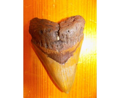
Los 176
*Megalodon tooth. A large and impressive tooth from the east coast of Florida, USA, 14 million years old The scientific name is Carcharocles Megalodon translates from Latin as big tooth which is evident from the scale of this tooth. It was the largest animal to have ever lived and would have reached lengths of around 60 feet. (1)
Los 192
*Cardiganshire. Speed (John), Cardigan Shyre Described with the due forme of the Shiretown as it was surveyed..., published Henry Overton, circa 1710, hand coloured engraved map, inset town plan of Cardigan, large strapwork cartouche, mileage scale and compass rose, 385 x 505 mm, mounted, framed and glazed (1)
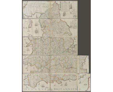
Los 198
England & Wales. Lea (Philip), Untitled map taken from Christopher Saxton's large scale map of England and Wales first published in 1583, this state published Philip Lea, Globemaker at ye Atlas and Hercules in Cheapside nere the corner of Fryday Street in London, [1687 - 1700], engraved map with contemporary outline colouring on five sheets, with two additional loose sheets, bound in contemporary vellum with manuscript title 'Mappe of England' on outside of vellum and rolled presumably to facilitate ease of carriage when travelling, half compass rose, table of longitude and latitude of principal towns, some fraying to map strip margins, appears to be lacking two smaller portions (East coast of Norfolk & Suffolk and South West Cornwall), each sheet approximately 285 x 855 mm, two loose sheets approximately 280 x 200 mm R.W.SHirley. Early Printed Maps of the British Isles 1477 - 1650, no.137, state 5. Christopher Saxton published his twenty sheet wall map in 1583. It was re-issued by Cade & Morgan in 1678. Philip Lea aquired the copper plates in about 1685 and re-published the map on a smaller scale designed to be used as a travelling map. He reduced the map to ten full sheets and four half sheets and removed a great deal of the sea, thus making the map relevant to land based travellers. The map was pasted into five horizontal strips. The top three sheets made up of two sheets and the last two sheets made of two sheets with a half sheet pasted at each end. It appears that two of these half sheets are lacking from this example. Philip Lea re-engraved the plates at least five times during his perod of ownership. This example is his 5th and final state and therefore state 7 of a total of nine states. Lea moved from Poultry to Cheapside in 1687 and remained there until 1700. Following Lea's death, Anne his widow, re-engraved and re-issued the map with Richard Glynne in 1720 and Thomas & John Bowles & Son repeated this in 1758. Scarce. (1)
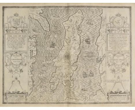
Los 210
Isle of Man. Speed (John), The Isle of Man exactly described and into Several Parishshes divided and with every Towne, Village, Baye, Creke and River therein conteyned. The bordringe Coasts wherewith is circulated in their situations sett and by the Compase accordigly shewed, with their true distance from every place into this Island by a severall scale observed, published Roger Rea, circa 1662, uncoloured engraved map, two large strapwork cartouches, compass rose and numerous rhumb lines, occasional small marginal closed tears not affecting image, small library blind stamp in margin, 385 x 510 mm, English text on verso (1)
Los 244
*Architecture. A mixed collection of approximately forty-five prints and engravings, mostly 18th & 19th century, engravings and prints of architectural prospects and elevations, details and garden plans, including some large scale, several with hand colouring, with examples by Miller, Piranesi, Hulsbergh, Herisset and Lotha, various sizes and condition (approx.45)
Los 297
*Prints & engravings. A mixed collection of thirty engravings, 19th and 20th century, large scale engravings including genre scenes, sporting, natural history, marine and topographical views, including thirteen restrikes, fishing gravures by G.Earl, signed in pencil by artist, three lithographs of vegetables and cattle and fourteen Goupil prints, including several with hand colouring, various sizes and condition (30)
Los 422
[La Serre M. de, Jean-Puget]. The Sweete Thoughts of Death and Eternity, [translated from the French], Paris, 1632, engraved title, some fraying mostly to leaves in first gathering, dampstaining, sewing weak, contemporary vellum over limp boards, covers loose and soiled, lacking ties, small 8vo, together with a defective & incomplete copy of Heaven opened, by William Cowper, 1632 and incomplete 17th century copy of Emblemes, by Francis Quarles, plus Forty Select Anthems in Score..., by Dr. Maurice Greene, 2 vols., 1743, and New Large Scale Ordnance Map of the British Isles, published George W. Bacon, circa 1880s Sold with all faults, not subject to return. (6)
Los 66
Cary (John). Cary's Traveller's Companion or a Delineation of the Turnpike Roads of England and Wales..., 1791, calligraphic title, advertisement and contents list, forty-three engraved maps printed back to back (including one folding), contemporary outline colouring, slight worming to index and advertisement at rear, book plate of Charles Armstrong, upper hinge cracked, contemporary half calf, rubbed and worn, 12mo, together with, Wallis (James), Wallis's New Pocket Edition of the English Counties or Travellers Companion..., 1810 or later], lacking title, forty-four engraved maps (including one double page), contemporary hand colouring, slight dust soiling and occasional staining throughout, near contemporary ownership signature to front pastedown, contemporary half morocco with gilt morocco label to upper siding, rubbed and worn, 12mo, with, Cary (John), Cary's Survey of the High Roads from London to Hampton Court, Bagshot..., on a scale of one Inch to the Mile..., 1790, printed title, two general maps of London and eighty engraved strip road maps on forty sheets, contemporary outline colouring, contemporary calf, lacking upper board, rear board detached, rubbed and worn, 8vo, plus, Gastineau (Henry), Wales Illustrated in a Series of Views..., 2 volumes, published Jones & Co., circa 1830, decorative title page, numerous uncoloured engravings, slight spotting, contemporary half calf, rubbed and worn, 4to, together with another nine volumes similar, including examples by Cruchley, Kearsley, Cary, Paterson and Lyson, various sizes and condition Sold as a collection of maps and engravings, not subject to return. (14)
Los 95
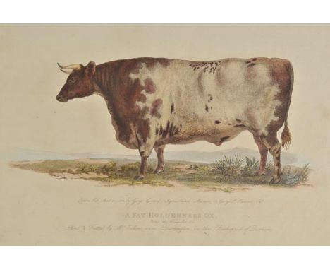
Garrard (George). A Description of the Different Varieties of Oxen Common in the British Isles; Embellished with Engravings; being an Accompaniment to a Set of Models of the Improved Breeds of Cattle Executed by George Garrard upon an Exact Scale from Nature under the Patronage of the Board of Agriculture, published J.Smeeton, 1800, printed title with 'Order of Binding' slip tipped in, binding slip with near contemporary ink marginalia, fifty-two (complete) engraved plates, fifty-one with contemporary hand colouring, plates dated 1799 - 1814, one plate (Native Irish or Kerry Bull) possibly from another volume, marbled endpapers, hinges strengthened, contemporary blind-stamped calf with gilt title to upper board, old re-back and corner repairs, oblong folio Nissen 1480. (1)
Los 219
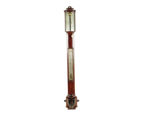
An early Victorian mahogany bowfront stick barometer, the silvered register inscribed 'Arnold & Dent London', with a vernier scale, with a turned bone adjuster and a thermometer above an ebonized urn cistern cover, c.1840, 96cm high. Provenance: The Property of the Rt. Hon. Sir Mathew Thorpe.
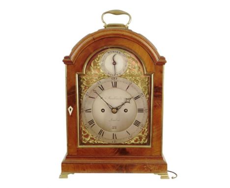
Los 225
A George III mahogany striking verge bracket clock by Brockbanks, the twin barrel four pillar movement with pull repeat and striking on a bell, the backplate engraved with flowers and a bird perched on a branch, within an arched brass mounted case with a triple pad top and a carrying handle, above fish scale panelled sides, the gilt dial with foliate pierced fret decoration and a silvered chapter ring with Roman and Arabic numerals, with date aperture and strike / silent dial, signed 'Brockbanks London', 41.9cm high, 27th wide, 18.5cm deep.
-
215354 Los(e)/Seite