Affinez votre recherche
Sale Section
- Antiquarian Books and Decorative Bindings (96)
- Art Reference (10)
- British Topography (17)
- Cartoons and Caricatures (17)
- Decorative Prints and Original Art (49)
- General Literature (23)
- General Stock (70)
- Historical Documents, Autographs and Ephemera (59)
- Library Furniture (7)
- Maps (72)
- Natural History (22)
- Travel and Exploration (47)
- Vinyl Records (9)
Estimation
Catégorie
- Books & Periodicals (302)
- Maps (77)
- Prints (41)
- Watercolours (18)
- Drawings & Pastels (13)
- Musical Instruments & Memorabilia (10)
- Arms, Armour & Militaria (9)
- Collectables (8)
- Furniture (7)
- Sporting Memorabilia & Equipment (4)
- Stamps (4)
- Oil, Acrylic paintings & Mixed Media (3)
- Entertainment Memorabilia (1)
- Photographs (1)
- Liste
- Grille
A subscription to the Price Guide is required to view results for auctions ten days or older. Click here for more information
![Istanbul. Du Bruyn (Cornelis), A Constantinopolen..., [1698 - 1714],](https://portal-images.azureedge.net/auctions-2019/srdom10133/images/c0b68d9f-a114-40dc-bf02-aa880137e15b.jpg?w=155&h=155)

Istanbul. Du Bruyn (Cornelis), A Constantinopolen ..., [1698 - 1714], uncoloured engraved panorama of Constantinople, Galata and Pera, old folds, ...
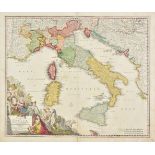
Italy Homann (Johann Baptist), Statuum totius Italiae novissima repraesentatio geographica simul exhibens Insulas Siciliae, Sardiniae, Corsicae Ma...
![Japan. Le Rouge (George Louis) Carte du Japon..., [1746],](https://portal-images.azureedge.net/auctions-2019/srdom10133/images/70f3f1a0-e62e-4c94-91a3-aa880137e329.jpg?w=155&h=155)
Japan. Le Rouge (George Louis) Carte du Japon et de la Corée Paris, [1746], engraved map of Japan and Korea, sparse outline colouring, 215 x 280 m...
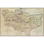
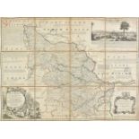
Kent. Greenwood (C.), Map of the County of Kent, from an actual survey made in the years 1819 & 1820, published G. Pringle junr., 1821, large engr...
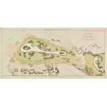
London. Basire (James), A Plan Shewing the Alterations Proposed in St James's Park, 20th June 1827, engraved map with contemporary hand colouring,...
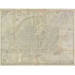
![London. Braun & Hogenberg, [1574 or later]](https://portal-images.azureedge.net/auctions-2019/srdom10133/images/499df218-4ab0-45cc-bd22-aa880137e4f8.jpg?w=155&h=155)
London. Braun (Georg & Frans Hogenberg). Londinum Feracissimi Angliae Regni Metropolis, [1574 or later], engraved map of London, with contemporary...
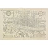
London. De Belleforest (Francois), La Ville de Londres. Londinum Feracissimi Angliae Regni Metropolis, published Paris, [1575], uncoloured woodcut...
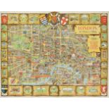
London. Lee (Kerry), London. The Bastion of Liberty, published by The Travel Association of The United Kingdom..., circa 1950, large colour lithog...
London. Rocque (John), [An Exact Survey of the citys of London Westminster ye Borough of Southwark and the Country near ten miles round, begun in ...
Manuscript Estate Plan. Plan of the Estate of Littleton in the Parish of Kirkoswald & County of Air, the Property of William Crawford, Esquire, Ph...
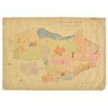
Manuscript maps. Eight manuscript maps for Upton & Ripple in Worcestershire, circa 1821 - 1871, six large pen and watercolour parish maps of Upton...
Map reference. A collection of approximately 130 volumes relating to maps, globes, cartography and map collecting, 20th century, including the fiv...
Ogilby (John). The Road from London to Bath & Wells in com. Somerset, The Road from London to Oakham in com. Rutland continued to Richmond in York...
Paris. De Belleforest (Francois), La Ville, Cité, Université & Faux-bourgs de Paris, 1575, uncoloured woodcut plan of Paris, old folds and red-rul...
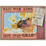
Propaganda map. Nazi War Aims, Grab! Grab! Grab!!!, circa 1940, colour photolithographic British propaganda map based on a map of Europe showing G...
Railway maps. Fifteen maps of the Midlands and Yorkshire, mostly late 19th and early 20th century
Railway maps. Fifteen maps of the Midlands and Yorkshire, mostly late 19th and early 20th century, folding lithographic maps, sectionalised and la...
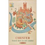
Railway posters. Lee (Kerry), Lee (Kerry), Chester, Travel there in rail comfort, British Railways, published Waterlow and Sons Limited, London & ...
River & Canal maps. Woodthorpe (V.), Plan of the proposed London Canal from a place call'd ...
River & Canal maps. Woodthorpe (V.), Plan of the proposed London Canal from a place call'd Hog Hole in the River Thames in the Parish of Datchet a...
River Thames. Palmer (Francis L.), To Accompany Mr. Palmer's Pamphlet on the Thames Floods, The Tower Bridge & to Illustrate the Tourist's Table. ...
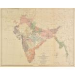
Saunders ( Trelawney ). An Atlas of Twelve Maps of India, Edward Stanford, 1889, additional half title, eleven lithographic double page and one fo...
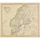
Scandinavia. A collection of thirty-five maps, mostly 19th century, engraved maps of Scandinavia, Denmark, Norway, Sweden and the Baltic Basin, ma...
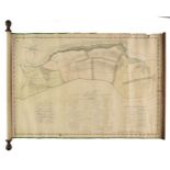
Scotland. Ainslie (John). A chart of part of Scotland from Berwick upon Tweed to Skateraw Harbour
Scotland. Ainslie (John). A chart of part of Scotland from Berwick upon Tweed to Skateraw Harbour in the County of Kincardine comprehending the Co...
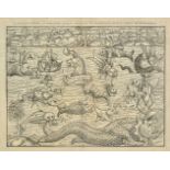
Sea Monsters. De Belleforest (Francois), Les Monstres Marins et Terrestres, Les quels on trouve en beacoup de lieux es parties septentionales, Par...
Simpson (Samuel). The Agreeable Historian or the Compleat English Traveller..., printed for R. Walker, 1746, title page and three maps (only) of T...
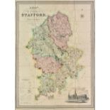
Staffordshire. Phillips (J. & Hutchings W.F.), A Map of the County of Stafford, Divided into Hundreds & Parishes from an accurate Survey, made in ...
The Map Collector. numbers. 1 - 74 (complete), December 1977 - Spring 1996, numerous colour and black & white illustrations throughout, all with o...
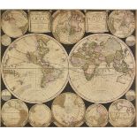
* World. Allard (Carel), Planisphaerium Terrestre sive Terrarum Orbis..., Amsterdam, circa 1696, engraved map with contemporary outline colouring,...
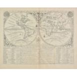
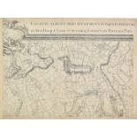
World. Chatelain (Henry Abraham), MapMonde ou Description Generale du Globe Terrestre, circa 1720, uncoloured engraved hemispheral map of the worl...
World. Chatelain (Henry Abraham), Mappe-Monde pour connoitre les progrés & les Conquestes les plus Remarquables des Provinces-Unies, Ainsy que cel...
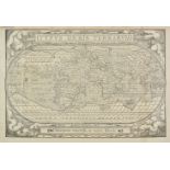
World. De Belleforest (Francois), Typus Orbis Terrarum, circa 1575, uncoloured woodcut map, old folds and 'red-ruled', one small closed tear affec...
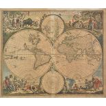
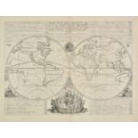
World. De Wit (Frederick), Nova Orbis Tabula in Lucem Edita, A. F. De Wit, Amsterdam, circa 1680, engraved hemispheral map with contemporary hand ...

World. Scott (R.), Hydrographical chart of the World on Wright or Mercators projection with tracts of the last Circumnavigators, circa 1815, engra...
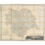
Yorkshire. A collection of ten folding maps, 18th & 19th century, including Darton (William & Son). The County of York, divided into its Ridings w...
Yorkshire. A mixed collection of twenty-one maps, 17th - 19th century, engraved maps, many with contemporary hand colouring, including examples by...
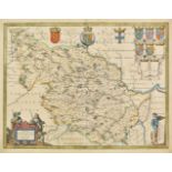
Yorkshire. Blaeu (Johannes), Ducatis Eboracensis pars Occidentalis; The West Riding of Yorke Shire, Amsterdam, circa 1645, engraved map with conte...
Yorkshire. Bowen (Emanuel), An Accurate Map of the West Riding of York Shire..., An Accurate Map of the North Riding of Yorkshire..., [and] An Acc...
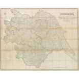
Yorkshire. Hobson (William Colling), This Map of Yorkshire is most respectfully dedicated to the nobility, clergy, gentry, landowners and manufact...
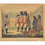
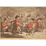
Bunbury (Henry William). Six military caricatures, The Relief, A Visit to the Camp, Recruits, A Recruiting Party, A Militia Meeting [and] A Camp S...
Bunbury (Henry William) . A collection of twenty-seven caricatures, circa 1790, etched caricatures, twenty-six with hand colouring, including twen...
Caricatures. A mixed collection of thirty-five caricatures, mostly 19th century, etched, lithographic and engraved English & French caricatures, i...
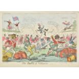
Cruikshank (George). The Battle of Vittoria, published T. Tegg, July 7th. 1813, etching with contemporary hand colouring, 240 x 350 mm, together w...
Gillray (James). A collection of approximately eighty caricatures, all H. G. Bohn impressions, circa 1849, uncoloured etched and engraved caricatu...
Gillray (James). French Volunteers, Marching to the conquest of Great Britain, published H. Humphrey, 1803, etching with contemporary hand colouri...
Gillray (James). Inspecting a Volunteer Corps in Hyde Park, Published H. Humphrey,1803, etching with contemporary hand colouring of Charles Earl o...
Gillray (James). Preliminaries of Peace! - or - John Bull and his little friends "Marching to Paris", published H. Humphrey, 1801, etching with co...
* Hogarth (William), A collection of approximately 110 engravings, mostly early 19th century
Hogarth (William), A collection of approximately 110 engravings, mostly early 19th century, uncoloured engravings, including sets such as 'Industr...
Military caricatures. A collection of twenty-two caricatures, early 19th century, etched, engraved and lithographic English and French caricatures...
* Military caricatures. A mixed collection of eleven caricatures, mostly early 19th century.
Military caricatures. A mixed collection of eleven caricatures, mostly early 19th century, engraved and etched hand coloured caricatures, includin...
* Military caricatures. A mixed collection of fourteen caricatures, mostly early 19th century
Military caricatures. A mixed collection of fourteen caricatures, mostly early 19th century, hand coloured etched and engraved caricatures, includ...
Military caricatures. A mixed group of ten caricatures, mostly early 19th century, etched and engraved hand coloured caricatures, including exampl...
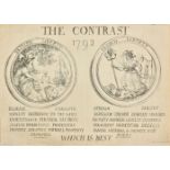
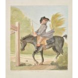
Rowlandson (Thomas). The Contrast, 1792, British Liberty [and] French Liberty, Which is Best, 1792, uncoloured etching of two allegorical medallio...
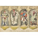
Rowlandson ( Thomas). The Sign of the Four Alls, circa 1810, etching with contemporary hand colouring, thread margins, 230 x 330 mm (Qty: 1) ...[...
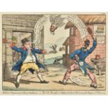
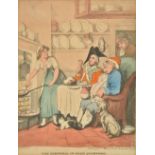
West (Temple, attrib.). John Bull teazed by an Ear-Wig!!!, published Wm. Holland, 1813, etching with contemporary hand colouring, 340 x 235 mm, mo...
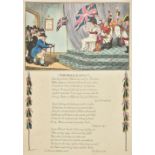
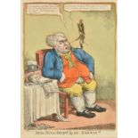
Williams (Charles). The Female Agent, published Walker, March 1809, etching with contemporary hand colouring with eighteen lines of verse below th...
![* Aldin (Cecil). The Kings Head Malmesbury, [and others], c.1921](https://portal-images.azureedge.net/auctions-2019/srdom10133/images/dbeda4f5-f644-499a-a1d8-aa880137fe24.jpg?w=155&h=155)
Aldin (Cecil). The Kings Head Malmesbury, The Bell at Stilton, The Golden Cross, Oxford, The Spread Eagle Midhurst, The George Inn Dorchester [and...
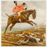
Aldin (Cecil). The Pytchley Hunt, Frank Freeman at Crick, 1912, colour photolithograph, signed by artist in pencil below image to lower left, 400 ...
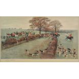
Aldin (Cecil). The South Berkshire Hunt, published Alfred Bell & Co. Ltd, 1925, lithograph, signed by artist to lower left in pencil, 350 x 605 mm...
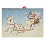
Ambler (Christopher Gifford, 1886-1965). Four original drawings of animals, the first in pen, ink & watercolour, depicting two Husky dogs pulling ...
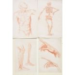
Artistic Anatomy. A series of 27 finely drawn studies of the human anatomy, probably English School, circa 1900, red chalk on wove paper, includin...