Affinez votre recherche
Sale Section
- Antiquarian Books and Decorative Bindings (96)
- Art Reference (10)
- British Topography (17)
- Cartoons and Caricatures (17)
- Decorative Prints and Original Art (49)
- General Literature (23)
- General Stock (70)
- Historical Documents, Autographs and Ephemera (59)
- Library Furniture (7)
- Maps (72)
- Natural History (22)
- Travel and Exploration (47)
- Vinyl Records (9)
Estimation
Catégorie
- Books & Periodicals (302)
- Maps (77)
- Prints (41)
- Watercolours (18)
- Drawings & Pastels (13)
- Musical Instruments & Memorabilia (10)
- Arms, Armour & Militaria (9)
- Collectables (8)
- Furniture (7)
- Sporting Memorabilia & Equipment (4)
- Stamps (4)
- Oil, Acrylic paintings & Mixed Media (3)
- Entertainment Memorabilia (1)
- Photographs (1)
- Liste
- Grille
A subscription to the Price Guide is required to view results for auctions ten days or older. Click here for more information

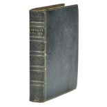
Radclyffe (James, 3rd Earl of Derwentwater). A Report... relating to the sale of the Estate, 1731
Radclyffe (James, 3rd Earl of Derwentwater, 1689-1716 ). A Report from the Committee to whom all the Books, Instruments, and Papers, relating to t...
Ridpath (George). The Border-History of England and Scotland, Deduced from the Earliest Times
Ridpath (George). The Border-History of England and Scotland, Deduced from the Earliest Times, 1776, toning and scattered spotting, Carlton Club b...
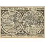
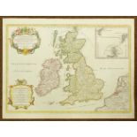
Speed (John). England Wales Scotland and Ireland Described and Abridged with ye Historic Relation of things Worthy memory from a farr larger Voulu...
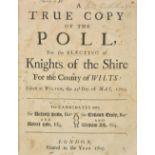
Wiltshire. A True Copy of the Poll, for the Electing of Knights of the Shire for the County of Wilts: Taken at Wilton, the 22d Day of May, 1705. T...
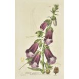
Baxter (William). British Phaenogamous Botany; or, Figures and Descriptions of the Genera of British Flowering Plants, 6 volumes, Oxford, 1834-184...
Beckett (Joseph). Elements & Practice of Mensuration and Land Surveying, adapted both to Public and Private Instruction. With an Appendix, contain...
British Birds, an illustrated magazine devoted to the birds of the British list, edited by H. F. Witherby at al, volumes 1-101, 1908-2008, (includ...
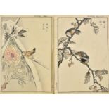
Bunrei (Maekawa, 1837-1917). Studies of Birds and Plants by Bunrei, Yokohama, Hobusho-kai, Meiji 18, 1885, 66 pages of colour woodblock, illustrat...
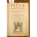
Evelyn (John). Sylva, 1664
Evelyn (John). Sylva, or a Discourse of Forest-Trees, and the Propagation of Timber in His Majesties Dominions, as it was delivered in the Royal S...
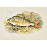
Houghton (Rev. W.). British Fresh-Water Fishes, 2 volumes, William MacKenzie, 1879, additional half title, forty-one (complete) engraved plates wi...
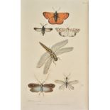
Kirby (William & Spence, William). An Introduction to Entomology: or Elements of the Natural History of Insects, 4 volumes, mixed editions, 1822-2...
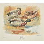
Millais (J. G.). The Natural History of the British Surface-Feeding Ducks, 1st edition, Longmans Green and Co., 1902, additional decorative half t...
Millais (John Guille). The Mammals of Great Britain and Ireland, 1st edition, 1904-6, half-titles, 243 photogravure, colour, chromolithographic or...
Morris (Beverley R.) British Game Birds and Wildfowl, 1st edition, 1855, 60 hand-coloured engraved plates, occasional light spotting and toning, c...
Morris (Beverley). British Game Birds and Wildfowl, Groombridge and Sons, 1864, 60 wood-engraved colour plates, tissue-guards, the first plate lac...
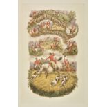
Surtees (R.S.) The Analysis of the Hunting Field. being a series of sketches of the principal characters that compose one, the whole forming a sli...
T & A D Poyser . Extinct Birds, by Julian P. Hume & Michael Walters, 2012, Seabirds, a natural history, by Anthony J. Gaston, 2004, The Historical...
The Ibis, A Quarterly Journal of Ornithology . 70 volumes, 3, 89, 91- 157 (1915-2015), numerous colour and black & white illustrations, book plate...
Thorburn (Archibald). British Mammals, 2 volumes, 1st edition, Longmans, Green and Co., 1920-1921, half title to each volume, 50 colour plates, bl...
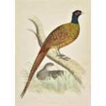
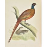
Thorburn (Archibald). Game Birds and Wild-Fowl of Great Britain and Ireland, 1st edition, Longmans, Green and Co., 1923 , 30 colour plates, each w...
Thorburn (Archibald). Game Birds and Wild - Fowl of Great Britain and Ireland, 1st edition, Longmans Green and Co., 1923, additional half title, t...
[Walton (Isaac & Cotton Charles)]. The Compleat Angler or The Contemplative Man's Recreation Being a Discourse of Fish and Fishing not Unworthy th...
Walton (Isaac & Cotton Charles). The Complete Angler or Contemplative Man's Recreation, being a Discourse on Rivers, Fish-Ponds, Fish, and Fishing...
![Walton (Izaak). The Compleat Angler [and:] White (Gilbert). Natural History of Selborne](https://portal-images.azureedge.net/auctions-2019/srdom10133/images/20134433-826a-46df-8581-aa880137ce97.jpg?w=155&h=155)
Walton (Izaak, & Charles Cotton). The Compleat Angler, edited by Richard Le Gallienne, illustrated by Edmund H. New, 2nd edition thus, John Lane, ...
Williamson (Thomas). Oriental Field Sports; being a complete, detailed and accurate description of the Wild Sports of the East, 2 volumes, 1808, a...
Wright (M, W and F. von). Svenska Faglar efter naturen och sten ritade, 3 volumes, Stockholm, 1927-29, 364 fine colour lithograph plates, illustra...
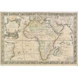
Africa. Danet (Guillaume), L'Afrique dressée sur les relations et nouvelles decouvertes de differens voyageurs..., published Paris, 1732, engraved...
![Africa. Vernon (Leo), East Africa [and] West Africa, 1948,](https://portal-images.azureedge.net/auctions-2019/srdom10133/images/ca93367d-39d6-44ab-92b2-aa880137cfbb.jpg?w=155&h=155)
Africa. Vernon (Leo), East Africa [and] West Africa, published H. M. S. O. 1948, two decorative pictorial maps showing the trade and produce grown...
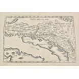
Balkans. Fries (Lorenz), Tabula V Europae (title on verso), Gaspard Trechsel, Lyons, [1535], uncoloured Ptolemaic woodblock map of the Balkans, sl...
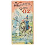
Board Game. The Wonderful Game of Oz, published Parker Brothers Inc, Salem Massachusetts, New York and London, 1921, chromolithographic board game...
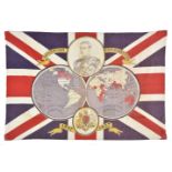
British Empire. Souvenir 'flag' for the coronation of Edward VIII, 1937, colour printed cotton 'flag' decorated with a double hemisphere map of th...
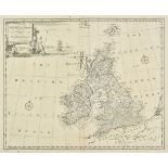
British Isles. A mixed collection of fifteen maps, mostly 18th century, engraved maps, including nine with colouring, with examples by Bowen, De L...
British Isles. De Belleforest (Francois), Des Isles de Bretagne, La Grand' Albion, qui est Angleterre & Hirlande & de leurs cites en general, Pari...
British Isles. Jaillot (Hubert), Les Isles Britanniques qui contiennent les Royaumes d' Angleterre, Escosse et Irlande..., circa 1695, hand colour...
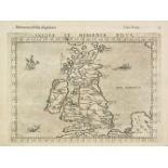
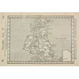
British Isles. Ruscelli (Girolamo), Anglia et Hibernia Nova, [1599], uncoloured engraved map, 190 x 265 mm, Italian text on verso, together with M...
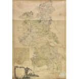
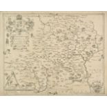
Buckinghamshire. Jefferys (Thomas), The county of Buckingham, surveyed in MDCCLXVI, VII and VIII...., 2nd edition, 1788, large scale engraved map ...
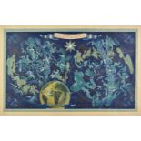
Celestial chart of the Constellations. Boucher (Lucien), Air France, Paris, 1938, large chromolithographic poster of the heavens and the zodiacal ...
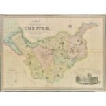
Cheshire. Swire (W. & Hutchings W.F.), A Map of the County Palatine of Chester, Divided into Hundreds & Parishes from an accurate survey, made in ...
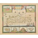
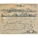
Crete. De Wit (Frederick), Insula Candia Ejusque Fortificatio , Amsterdam, circa 1680, hand coloured engraved map, six inset vignettes of islands ...
* Crete. Jansson (Jan), Creta Iovis Magni Medio jacet Insula ponto ex conatibus geographicic Abrahami Ortely, circa 1650, uncoloured engraved map,...
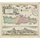
Crete. Lotter (Tobias Conrad), Insula Creta nunc Candia in sua IV Territoria distincta cum aliquod adjacentibus Aegei maris Insulis imprimis nova ...
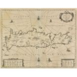
* Crete. Visscher (Nicolas), Insula Candia olim Creta, Amsterdam, circa 1680, uncoloured engraved map with panorama of the Turkish siege of Candie...
![Cuba and the West Indies. Ortelius (Abraham), Culicanae..., [1602]](https://portal-images.azureedge.net/auctions-2019/srdom10133/images/a18fa740-d703-47e3-99c4-aa880137d7be.jpg?w=155&h=155)
Cuba and the West Indies. Ortelius (Abraham), Culicanae Americae regionis descriptio [on sheet with] Hispaniolae, Cubae, Aliarumque Insularum Circ...
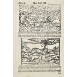
Cyprus. Munster (Sebastian), Cyprus, Basel, circa 1550, uncoloured woodblock map with a panel below the map showing a leaping stag and a sheep dri...
![Cyprus. Magini (Giovanni Antonio), Cypri Insula, published Venice, [1596 or later]](https://portal-images.azureedge.net/auctions-2019/srdom10133/images/c2996c19-ed0b-44dd-8f18-aa880137d8f5.jpg?w=155&h=155)
Cyprus. Magini (Giovanni Antonio), Cypri Insula, published Venice, [1596 or later], uncoloured map, engraved by G.Porro, Latin text on verso of ma...
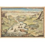
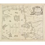
Dardanelles. De Fer (Nicolas), Veue des Dardanelles de Constantinople, [1705], hand coloured engraved pictorial map of a Bird's-eye view of the en...
Dawson (Lt. R. K.., Royal Engineers). Plans of the Municipal Boroughs of England and Wales; Showing their Boundaries and Division into Wards, 1832...
England & Wales. Wallis (John), Wallis's Tour through England and Wales, A New Geographical Pastime, published 24th December 1794, 1794, engraved ...
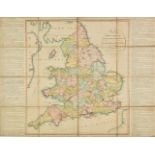
England & Wales. Lewis (Samuel & Co., publisher), A Map of England & Wales divided into Counties, Parliamentary Divisions & Dioceses, shewing the ...
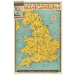
England & Wales. The New Pictorial Map of England and Wales, published Geographia Limited. circa 1935, pictorial colour lithographic map, old fold...
Essex. Untitled Ordnance Survey map, sold by Edward Stanford Ltd. 1914, large engraved map with bright contemporary outline colouring, sectionalis...
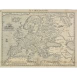
Europe. De Belleforest (Francois), Le Carte D'Europe, published Paris,1575, uncoloured woodblock map based on Ortelius's 1570 map, old folds and r...
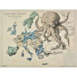
Europe. Rose (F. W.), Serio-Comic War Map for the Year 1877, published G. W. Bacon & Co., colour lithographic map with explanatory text (in German...
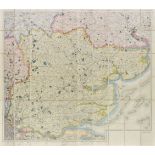
Fisher (Son & Co., publisher) . Fisher's County Atlas of England and Wales compiled from Authentic surveys and corrected to the present time..., [...
Greece and the Peloponnese. A collection of twenty-one maps, mostly 17th & 18th century, engraved maps, several with hand colouring, including exa...
Hertfordshire. Saxton (Christopher, Web William), Hartfordiae comitatus nova vera ac particularis descriptio, 1642, uncoloured engraved map, large...
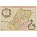
Holy Land. Jaillot (Alexis-Hubert), Judea seu Terra Sancta quae Hebraeorum sive Israelitarum in suas duodecim Tribus divisa..., 1691, large engrav...
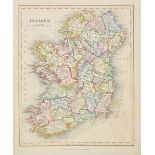
Ireland. A collection of thirty maps, mostly 19th century, engraved maps, many with contemporary outline colouring, with examples by Johnston, Wel...
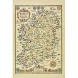
Ireland. Taylor (A. E.), Pratts High Test Plan of Ireland, 1933, pictorial colour photo-lithographic map, descriptive text by S. P. B. Mais on ver...
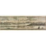
Istanbul. De Bruyn (Cornelis), Serraglio di Constantinopoli, circa 1700, uncoloured engraved panorama of Scutari and Constantinople, old folds, sl...