Keine Abbildung Los 243 India.- Execution of the assassin Sher Ali.- Bombay Gazette Extra edition. Monday March 18, 1872.... 243India.- Execution of the assassin Sher Ali.- Bombay Gazette Extra edition. Monday March 18, 1872.... Forum Auctions India.- Execution of the assassin Sher Ali.- Bombay Gazette. Extra edition. Monday March 18, 1872...Execution of Shere Ali, handbill, folds, littl... Auf die Merkliste Live
Keine Abbildung Los 1552 WALL MAP OF CHINA, CIRCA 1900S 1552WALL MAP OF CHINA, CIRCA 1900S McTear's WALL MAP OF CHINA, CIRCA 1900S hand painted on linen with hanging loops Provenance: From the estate of an Edinburgh-based Asian art collector. A ... Auf die Merkliste Live
Keine Abbildung Los 1041 CDs, various genres, maps, prints:- Three Boxes. 1041CDs, various genres, maps, prints:- Three Boxes. Sheffield Auction Gallery CDs, various genres, maps, prints:- Three Boxes. Auf die Merkliste Live
Keine Abbildung Los 1048 Vintage to Modern O.S Maps, Platts Road Atlas of England and Wales, Arthur Mee guides and a 1048Vintage to Modern O.S Maps, Platts Road Atlas of England and Wales, Arthur Mee guides and a Sheffield Auction Gallery Vintage to Modern O.S Maps, Platts Road Atlas of England and Wales, Arthur Mee guides and a collection of railway related books:- Two Boxes. Auf die Merkliste Live
Keine Abbildung Los 1369 Bartholomews Folding Linen Backed Maps, 37, in fitted leather case, 33.5cm wide. 1369Bartholomews Folding Linen Backed Maps, 37, in fitted leather case, 33.5cm wide. Sheffield Auction Gallery Bartholomews Folding Linen Backed Maps, 37, in fitted leather case, 33.5cm wide. Auf die Merkliste Live
Keine Abbildung Los 144 Two Robert Morden (English, 1650-1703) engraved and hand coloured maps. 'Somerset Shire', 37. 144Two Robert Morden (English, 1650-1703) engraved and hand coloured maps. 'Somerset Shire', 37. Mendip Auction Rooms Two Robert Morden (English, 1650-1703) engraved and hand coloured maps. 'Somerset Shire', 37.5cm x 45cm and 'Dorset Shire', 37.5cm x 45cm, both fr... Auf die Merkliste Live
Keine Abbildung Los 145 A 17th century hand coloured engraved map of Groningen, the Netherlands. 145A 17th century hand coloured engraved map of Groningen, the Netherlands. Mendip Auction Rooms A 17th century hand coloured engraved map of Groningen, the Netherlands. The title cartouche in the upper right hand corner, publication details a... Auf die Merkliste Live
Keine Abbildung Los 146 John Norden, a 16th/17th century hand coloured and engraved map of Sussex. 146John Norden, a 16th/17th century hand coloured and engraved map of Sussex. Mendip Auction Rooms John Norden, a 16th/17th century hand coloured and engraved map of Sussex. 'Sussexia siue Southlex olim pars Regnorum', 26.5cm x 43cm, framed and ... Auf die Merkliste Live
Keine Abbildung Los 156 Saxon Hole, a 17th century hand coloured and engraved map of Cheshire. 156Saxon Hole, a 17th century hand coloured and engraved map of Cheshire. Mendip Auction Rooms Saxon Hole, a 17th century hand coloured and engraved map of Cheshire. 'Cestriae Comitatus-Romains Legionibus et Colonijs clim infignis vera et ab... Auf die Merkliste Live
Keine Abbildung Los 168 Emanuel Bowen (British 1694-1767), a 18th century hand painted engraved map of Worcestershire. 168Emanuel Bowen (British 1694-1767), a 18th century hand painted engraved map of Worcestershire. Mendip Auction Rooms Emanuel Bowen (British 1694-1767), a 18th century hand painted engraved map of Worcestershire. 'An Accurate Map Of The County Of Worcester Divided... Auf die Merkliste Live
Keine Abbildung Los 1 Framed colour map of Western USA and Mexico 1Framed colour map of Western USA and Mexico Martello Auctions Framed colour map of Western USA and Mexico (collection only) Auf die Merkliste Live
Keine Abbildung Los 2 Framed colour map of South Africa 2Framed colour map of South Africa Martello Auctions Framed colour map of South Africa (Collection only) Auf die Merkliste Live
Keine Abbildung Los 3 Framed colour map of Africa 3Framed colour map of Africa Martello Auctions Framed colour map of Africa (collection only) Auf die Merkliste Live
Keine Abbildung Los 4 Framed colour map of France dated 1762 but not not guaranteed to be of this date 4Framed colour map of France dated 1762 but not not guaranteed to be of this date Martello Auctions Framed colour map of France dated 1762 but not not guaranteed to be of this date (collection only) Auf die Merkliste Live
Keine Abbildung Los 5 Framed colour printed map of Egypt dated 1850 but most likely a print 5Framed colour printed map of Egypt dated 1850 but most likely a print Martello Auctions Framed colour printed map of Egypt dated 1850 but most likely a print (collection only) Auf die Merkliste Live
Mindestpreis nicht eingehalten Keine Abbildung Los 86 After Abraham Ortelius (Belgian 1527-1598) Europam, Sive Celticam Veterem (map of the Celtic Empire) 86After Abraham Ortelius (Belgian 1527-1598) Europam, Sive Celticam Veterem (map of the Celtic Empire) 1818 Auctioneers After Abraham Ortelius (Belgian 1527-1598) Europam, Sive Celticam Veterem (map of the Celtic Empire) from Ortelius's Theatrum Orbis Terrarum, firs... Auf die Merkliste Timed
Mindestpreis nicht eingehalten Keine Abbildung Los 348 A large framed Elizabeth II silver map of Great Britain, the large silver panel having an engraved 348A large framed Elizabeth II silver map of Great Britain, the large silver panel having an engraved 1818 Auctioneers A large framed Elizabeth II silver map of Great Britain, the large silver panel having an engraved map of Great Britain with county borders and th... Auf die Merkliste Timed
Keine Abbildung Los 96 POWELL AND PRESSBURGER - THE 49TH PARALLEL (1941) - ORIGINAL DUTCH ONE-SHEET POSTER. 96POWELL AND PRESSBURGER - THE 49TH PARALLEL (1941) - ORIGINAL DUTCH ONE-SHEET POSTER. Omega Auctions An original Dutch poster for the Powell and Pressburger feature 'The 49th Parallel' (1941). Measures approx 25 x 35". Folded. In fragile condition... Auf die Merkliste Live
Keine Abbildung Los 10 FASHION. 10FASHION. Bearnes Hampton & Littlewood FASHION. Journal des Demoiselles, vingt-huitième année, Paris: Bureau du Journal 1860, 24 hand-coloured engraved plates, 2 folding monochrome plat... Auf die Merkliste Live
Keine Abbildung Los 118 FENELON, François de Salignac de la Motte. Les Avantures de Telemaque fils d'Ulysse... 118FENELON, François de Salignac de la Motte. Les Avantures de Telemaque fils d'Ulysse... Bearnes Hampton & Littlewood FENELON, François de Salignac de la Motte. Les Avantures de Telemaque fils d'Ulysse...nouvelle edition..., London: B. Dod 1742, engr. portrait fro... Auf die Merkliste Live
Keine Abbildung Los 162 MOUHY, Charles de Fieux, chevalier de. 162MOUHY, Charles de Fieux, chevalier de. Bearnes Hampton & Littlewood MOUHY, Charles de Fieux, chevalier de. La Paysanne Parvenu, ou les Mémoires de Madame La Marquise de L.V., 4 vols., Amsterdam: aux dépens de la Co... Auf die Merkliste Live
Keine Abbildung Los 200 NORRIS-NEWMAN, Charles L. 200NORRIS-NEWMAN, Charles L. Bearnes Hampton & Littlewood NORRIS-NEWMAN, Charles L. In Zululand with The British throughout the War of 1879, 1st edition, London: W.H.Allen & Co. 1880, mounted photographic... Auf die Merkliste Live
Keine Abbildung Los 216 BORLASE, William. 216BORLASE, William. Bearnes Hampton & Littlewood BORLASE, William. Observations on the Antiquities Historical and Monumental, of the County of Cornwall..., 1st edition, Oxford: W. Jackson 1754, t... Auf die Merkliste Live
Keine Abbildung Los 224 LYSONS, Daniel & Samuel. Magna Brittania,... 224LYSONS, Daniel & Samuel. Magna Brittania,... Bearnes Hampton & Littlewood LYSONS, Daniel & Samuel. Magna Brittania,... volume the first, containing Bedfordshire, Berkshire and Buckinghamshire, London: T.Cadell & W.Davies... Auf die Merkliste Live
Keine Abbildung Los 238 DE LA BECHE, Henry T. 238DE LA BECHE, Henry T. Bearnes Hampton & Littlewood DE LA BECHE, Henry T. Report on the Geology of Cornwall, Devon and West Somerset, London: Longman et al. 1839, hand-coloured engr. folding map to ... Auf die Merkliste Live
Keine Abbildung Los 267 ATLASES. BUTLER, Samuel. An Atlas of Ancient Geography, London: Longman & Co. 267ATLASES. BUTLER, Samuel. An Atlas of Ancient Geography, London: Longman & Co. Bearnes Hampton & Littlewood ATLASES. BUTLER, Samuel. An Atlas of Ancient Geography, London: Longman & Co., nd, 22 double-page engr. maps, hand-coloured in outline, contemp. i... Auf die Merkliste Live
Keine Abbildung Los 269 BERKSHIRE. KIP, Johannes, after Knyff, Leonard. 269BERKSHIRE. KIP, Johannes, after Knyff, Leonard. Bearnes Hampton & Littlewood BERKSHIRE. KIP, Johannes, after Knyff, Leonard. Hamstead Marshall in the County of Bercks, one of the Seats of the Rt Hon'ble William Lord Craven.... Auf die Merkliste Live
Keine Abbildung Los 270 BRITISH ISLES. A group of seven C18th maps: ANDRÉ, Pierre [Peter Andre] (engr. 270BRITISH ISLES. A group of seven C18th maps: ANDRÉ, Pierre [Peter Andre] (engr. Bearnes Hampton & Littlewood BRITISH ISLES. A group of seven C18th maps: ANDRÉ, Pierre [Peter Andre] (engr.) after BONNE, Rigobert. Isles- Britanniques; contenant les Royaumes... Auf die Merkliste Live
Keine Abbildung Los 271 BUFFIER. Claude. 271BUFFIER. Claude. Bearnes Hampton & Littlewood BUFFIER. Claude. Géographie Universelle exposée dans les différentes métodes qui peuvent abréger l'étude et faciliter l'usage de cette Science…et ... Auf die Merkliste Live
Keine Abbildung Los 272 COLLINS, Captain Greenvile. Great Britain's Coasting Pilot. In Two Parts. 272COLLINS, Captain Greenvile. Great Britain's Coasting Pilot. In Two Parts. Bearnes Hampton & Littlewood COLLINS, Captain Greenvile. Great Britain's Coasting Pilot. In Two Parts. Being a new and Exact Survey of the Sea-Coast of England and Scotland fr... Auf die Merkliste Live
Keine Abbildung Los 274 DERBYSHIRE. BLOME, Richard. A Mapp of the County of Darbye with its Hundreds, [c. 274DERBYSHIRE. BLOME, Richard. A Mapp of the County of Darbye with its Hundreds, [c. Bearnes Hampton & Littlewood DERBYSHIRE. BLOME, Richard. A Mapp of the County of Darbye with its Hundreds, [c.1673 for Britannia], engraved map, later hand colour, a little st... Auf die Merkliste Live
Keine Abbildung Los 278 DEVON. GREENWOOD, C. & J. 278DEVON. GREENWOOD, C. & J. Bearnes Hampton & Littlewood DEVON. GREENWOOD, C. & J. Map of the County of Devon, from an actual survey made in the years 1825 & 1826, London: Greenwood & Co. 1829, hand-colo... Auf die Merkliste Live
Keine Abbildung Los 281 EGYPT. WYLD, James. 281EGYPT. WYLD, James. Bearnes Hampton & Littlewood EGYPT. WYLD, James. Map of the Nile District between Assouan & Khartoom (Wylde's Military Staff Map, Wylde's Egyptian Series No. 13), London: Jame... Auf die Merkliste Live
Keine Abbildung Los 282 ELLIS, John. Ellis's English Atlas: or, a Compleat Chorography of England and Wales: in Fifty Maps.. 282ELLIS, John. Ellis's English Atlas: or, a Compleat Chorography of England and Wales: in Fifty Maps.. Bearnes Hampton & Littlewood ELLIS, John. Ellis's English Atlas: or, a Compleat Chorography of England and Wales: in Fifty Maps..., London: Robert Sayer et al. 1768, title, 49... Auf die Merkliste Live
Keine Abbildung Los 284 FRANCE. Carte de la Navigation Intérieure de la France, 284FRANCE. Carte de la Navigation Intérieure de la France, Bearnes Hampton & Littlewood FRANCE. Carte de la Navigation Intérieure de la France, Dressée par ordre de Monsieur le Directeur Général des Ponts & Chaussées et des Mines, 182... Auf die Merkliste Live
Keine Abbildung Los 286 GENEVA. DOWER, John Crane. Geneva, hand-coloured engraved plan, London: Orr & Smith, [c. 286GENEVA. DOWER, John Crane. Geneva, hand-coloured engraved plan, London: Orr & Smith, [c. Bearnes Hampton & Littlewood GENEVA. DOWER, John Crane. Geneva, hand-coloured engraved plan, London: Orr & Smith, [c.1836], f&g, 22.5cm x 27cm. Auf die Merkliste Live
Keine Abbildung Los 289 HAMPSHIRE. MORDEN, Robert. 289HAMPSHIRE. MORDEN, Robert. Bearnes Hampton & Littlewood HAMPSHIRE. MORDEN, Robert. Hampshire, hand-coloured engraved map [1695, from Camden's Britannia], foxing, f&g, 43cm x 49cm; MOLL, Herman. Hamp Shi... Auf die Merkliste Live
Keine Abbildung Los 290 HAMPSHIRE. SPEED, John. 290HAMPSHIRE. SPEED, John. Bearnes Hampton & Littlewood HAMPSHIRE. SPEED, John. Hantshire described and devided, Thomas Bassett & Richard Chiswell [1676], hand coloured engraved map, inset town plan of ... Auf die Merkliste Live
Keine Abbildung Los 292 INDIA. ARROWSMITH, Aaron. Hindoostan, London: R.H. 292INDIA. ARROWSMITH, Aaron. Hindoostan, London: R.H. Bearnes Hampton & Littlewood INDIA. ARROWSMITH, Aaron. Hindoostan, London: R.H.Laurie 1851, hand-coloured engraved map, sectionalised and laid on linen, occasional spotting an... Auf die Merkliste Live
Keine Abbildung Los 294 KNIPE, James Alexander. 294KNIPE, James Alexander. Bearnes Hampton & Littlewood KNIPE, James Alexander. Geological & Mineralogical Map of England & Wales, with Parts of Scotland, Ireland & France...3rd edition, London: J.A.Kni... Auf die Merkliste Live
Keine Abbildung Los 297 MAP, CHURCHILL. Dunkirk to Berlin June, 1940 - July, 1945 Journeys Undertaken By The Rt. Honble. 297MAP, CHURCHILL. Dunkirk to Berlin June, 1940 - July, 1945 Journeys Undertaken By The Rt. Honble. Bearnes Hampton & Littlewood MAP, CHURCHILL. Dunkirk to Berlin June, 1940 - July, 1945 Journeys Undertaken By The Rt. Honble. Winston S. Churchill..., London: George Philip & ... Auf die Merkliste Live
Keine Abbildung Los 298 NORTHERN COUNTIES. MORDEN, Robert. 298NORTHERN COUNTIES. MORDEN, Robert. Bearnes Hampton & Littlewood NORTHERN COUNTIES. MORDEN, Robert. Three hand-coloured engraved maps [1695 or later]: Northumberland, 43cm x 36.5cm; Cumberland, 37.5cm x 43.5cm; ... Auf die Merkliste Live
Keine Abbildung Los 300 PERKINS, Stanley Kendrick. 300PERKINS, Stanley Kendrick. Bearnes Hampton & Littlewood PERKINS, Stanley Kendrick. 'IDRIS', 1921, coloured print, split to creases with tape repairs, f&g, 17cm x 55cm. Auf die Merkliste Live
Keine Abbildung Los 309 SOMERSET. CRUCHLEY, George Frederick. 309SOMERSET. CRUCHLEY, George Frederick. Bearnes Hampton & Littlewood SOMERSET. CRUCHLEY, George Frederick. Cruchley's Road and Railway Map of the County of Somerset, London & Edinburgh: Gall & Inglis, f&g, 50.5cm x ... Auf die Merkliste Live
Keine Abbildung Los 311 STAFFORDSHIRE. KIP, William. 311STAFFORDSHIRE. KIP, William. Bearnes Hampton & Littlewood STAFFORDSHIRE. KIP, William. Staffordiae comitatus pars olim Cornauiorum, [1637], hand-coloured engraved map, strapwork cartouche, mileage scale, ... Auf die Merkliste Live
Keine Abbildung Los 312 STANFORD, Edward. 312STANFORD, Edward. Bearnes Hampton & Littlewood STANFORD, Edward. Stanford's two inch map of London and its environs, Municipal Edition, London: Edward Stanford Ltd., nd, coloured map, with addi... Auf die Merkliste Live
Keine Abbildung Los 330 GIBRALTAR. Garrison Orders, July 1829 to Nov 1829, manuscript on paper, c.127 leaves, contemp. 330GIBRALTAR. Garrison Orders, July 1829 to Nov 1829, manuscript on paper, c.127 leaves, contemp. Bearnes Hampton & Littlewood GIBRALTAR. Garrison Orders, July 1829 to Nov 1829, manuscript on paper, c.127 leaves, contemp. calf scuffed, cracked to joints (tape repairs), 13.... Auf die Merkliste Live
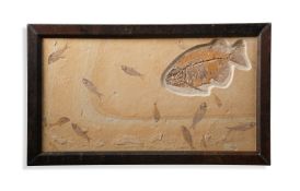
Keine Abbildung Los 151 ‡ PHAREODUS TESTIS (KNIGHTIA EOCAENA) 151‡ PHAREODUS TESTIS (KNIGHTIA EOCAENA) Dreweatts 1759 ‡ PHAREODUS TESTIS (KNIGHTIA EOCAENA) Medium Eocene 50 m.a White River FMT Kemmerer Wyoming 51cm high, 86cm wide ■ After t... Auf die Merkliste Live
Keine Abbildung Los 206 A MAP OF POOLE HARBOUR 206A MAP OF POOLE HARBOUR Dreweatts 1759 A MAP OF POOLE HARBOUR 201.5 x 134cm (79¼ x 52¾ in.) Auf die Merkliste Live
Mindestpreis nicht eingehalten Keine Abbildung Los 18 ANONYMOUS AND UNIDENTIFIED Roses; Chrysanthemums; Bamboo, Korea, late 20th century 18ANONYMOUS AND UNIDENTIFIED Roses; Chrysanthemums; Bamboo, Korea, late 20th century Bonhams ANONYMOUS AND UNIDENTIFIED Roses; Chrysanthemums; Bamboo, Korea, late 20th century Ink and color or ink on paper, all matted, bamboo with a seal. ... Auf die Merkliste Timed
Mindestpreis nicht eingehalten Keine Abbildung Los 144 NEW ENGLAND IN 1830. An Improved Reference and Distance Map of the Eastern Section of New Englan... 144NEW ENGLAND IN 1830. An Improved Reference and Distance Map of the Eastern Section of New Englan... Bonhams NEW ENGLAND IN 1830. An Improved Reference and Distance Map of the Eastern Section of New England. New Haven: J.R. Goodno, 1830. Large rolling en... Auf die Merkliste Timed
Keine Abbildung Los 42 A glazed print of an early map of the world 42A glazed print of an early map of the world Unique Auctions A glazed print of an early map of the world Auf die Merkliste Live
Keine Abbildung Los 69 A framed and glazed map of Cornwall 40cm x 28cm 69A framed and glazed map of Cornwall 40cm x 28cm Unique Auctions A framed and glazed map of Cornwall 40cm x 28cm Auf die Merkliste Live
Keine Abbildung Los 473 Cartography - a mounted Royal Atlas of England & Whales (plate no.52) map of Birmingham by John 473Cartography - a mounted Royal Atlas of England & Whales (plate no.52) map of Birmingham by John Wellers Auctions Cartography - a mounted Royal Atlas of England & Whales (plate no.52) map of Birmingham by John Bartholomew & Co, 44 x 34cm Auf die Merkliste Live
Keine Abbildung Los 1150 ERIC SLATER (BRITISH, 1896-1963) 1150ERIC SLATER (BRITISH, 1896-1963) Bellmans ERIC SLATER (BRITISH, 1896-1963)A Sussex Mill signed and titled 'Eric Slater' (lower margin) woodcut 23.5 x 34cm ARR Provenance Private collectio... Auf die Merkliste Live
Keine Abbildung Los 188 KOITSU ISHIWATA (1897 – 1987) Dusk at Choshi Machi 188KOITSU ISHIWATA (1897 – 1987) Dusk at Choshi Machi Azca Auctions KOITSU ISHIWATA (1897 – 1987) Dusk at Choshi Machi 1932 A woodblock print on paper depicting a traditional alley in the fading light, with a si... Auf die Merkliste Live
Keine Abbildung Los 232 China and Japan, travel and topography, 232China and Japan, travel and topography, Sworders China and Japan, travel and topography, including: Scenic views of China, plus a few maps (qty.)Provenance: Arthur Probsthain bookshop, London. Auf die Merkliste Live
Keine Abbildung Los 1610 Robert Morden (c.1650 - 1703), a two-page coloured map, Shropshire, 36cm x 44cm, maple frame 1610Robert Morden (c.1650 - 1703), a two-page coloured map, Shropshire, 36cm x 44cm, maple frame Bamfords Auctioneers & Valuers Robert Morden (c.1650 - 1703), a two-page coloured map, Shropshire, 36cm x 44cm, maple frame Auf die Merkliste Live
Keine Abbildung Los 2311 A George III needlework map sampler, England and Wales, with part of Scotland and Ireland, 38cm x 2311A George III needlework map sampler, England and Wales, with part of Scotland and Ireland, 38cm x Bamfords Auctioneers & Valuers A George III needlework map sampler, England and Wales, with part of Scotland and Ireland, 38cm x 32.5cm, c.1810 Auf die Merkliste Live
Keine Abbildung Los 303 Atlanten - - Riedig, M. Taschen-Atlas 303Atlanten - - Riedig, M. Taschen-Atlas Nosbüsch & Stucke GmbH Auktionen Berlin Atlanten - - Riedig, M. Taschen-Atlas über alle Theile der Erde in 24 Karten gezeichnet von M. Riedig. Mit 24 (23 grenzkolorierten) Karten. Leipzi... Auf die Merkliste Live


![BRITISH ISLES. A group of seven C18th maps: ANDRÉ, Pierre [Peter Andre] (engr.](https://portal-images.azureedge.net/auctions-2025/bearne10187/images/8091396d-f513-4538-8fd7-b2ca00cf3b57.jpg?h=175)