Keine Abbildung Los 896 SOMERSET C.C.C. Over 110 home and away scorecards, 82 from the 1950's including v Australia 1953 and 896SOMERSET C.C.C. Over 110 home and away scorecards, 82 from the 1950's including v Australia 1953 and Sportingold Limited SOMERSET C.C.C. Over 110 home and away scorecards, 82 from the 1950's including v Australia 1953 and 1956, Pakistan 1954, India 1959, West I... Live
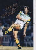
Keine Abbildung Los 1266 FRANK WORTHINGTON Autographed 12 x 8 col photo of Worthington in full length action for the Tampa 1266FRANK WORTHINGTON Autographed 12 x 8 col photo of Worthington in full length action for the Tampa Sportingold Limited FRANK WORTHINGTON Autographed 12 x 8 col photo of Worthington in full length action for the Tampa Bay Rowdies, c1981, signed All The Best in ... Live
Keine Abbildung Los 3500 END OF SALE, THANK YOU FOR YOUR BIDDING. OUR NEXT SALE IS ON THE WEDNESDAY 14TH AND THURSDAY 15TH 3500END OF SALE, THANK YOU FOR YOUR BIDDING. OUR NEXT SALE IS ON THE WEDNESDAY 14TH AND THURSDAY 15TH Ashley Waller Auctioneers END OF SALE, THANK YOU FOR YOUR BIDDING. OUR NEXT SALE IS ON THE WEDNESDAY 14TH AND THURSDAY 15TH MAY Live
Keine Abbildung Los 797 A tin of J Huthart & Co Hosiers & General Drapers of Carlisle Superior Pins, late 19th / early 797A tin of J Huthart & Co Hosiers & General Drapers of Carlisle Superior Pins, late 19th / early Laidlaw Auctioneers & Valuers A tin of J Huthart & Co Hosiers & General Drapers of Carlisle Superior Pins, late 19th / early 20th Century, 11 cm x 7 cm x 2.5 cm Auf die Merkliste Live
Keine Abbildung Los 1366 Framed 'Keep Mum, She's Not Dumb' poster, two unframed Spanish posters and four similar maps (7) 1366Framed 'Keep Mum, She's Not Dumb' poster, two unframed Spanish posters and four similar maps (7) Ryedale Auctioneers Framed 'Keep Mum, She's Not Dumb' poster, two unframed Spanish posters and four similar maps (7) Shipping POA https://www.bradleys.ltd/quotation-r... Auf die Merkliste Live
Keine Abbildung Los 21 The Royal Geographical Society hall marked silver map of the World 21The Royal Geographical Society hall marked silver map of the World Bigwood Fine Art Auctioneers The Royal Geographical Society hall marked silver map of the World Auf die Merkliste Live
Keine Abbildung Los 124 Map of Warwickshire following Rocque 1769, together with a map of Jersey 124Map of Warwickshire following Rocque 1769, together with a map of Jersey Bigwood Fine Art Auctioneers Map of Warwickshire following Rocque 1769, together with a map of Jersey Auf die Merkliste Live
Keine Abbildung Los 159 A selection of Ordnance Survey maps 159A selection of Ordnance Survey maps Bigwood Fine Art Auctioneers A selection of Ordnance Survey maps Auf die Merkliste Live
Keine Abbildung Los 191 Two views of the Holy sites of Islam : the Masjid al-Haram at Mecca and the Masjid al-Nabawi at M... 191Two views of the Holy sites of Islam : the Masjid al-Haram at Mecca and the Masjid al-Nabawi at M... Roseberys London Two views of the Holy sites of Islam : the Masjid al-Haram at Mecca and the Masjid al-Nabawi at Medina, India, early 20th century, Opaque pigment... Auf die Merkliste Live
Keine Abbildung Los 246 Highland School, a pair of colour prints, one titled Summer Isles, 249/250, 15cm x 40cm, framed 246Highland School, a pair of colour prints, one titled Summer Isles, 249/250, 15cm x 40cm, framed Bigwood Fine Art Auctioneers Highland School, a pair of colour prints, one titled Summer Isles, 249/250, 15cm x 40cm, framed Auf die Merkliste Live
Keine Abbildung Los 307 A selection of assorted Ordance Survey maps, a framed West Riding print with assorted town maps, 307A selection of assorted Ordance Survey maps, a framed West Riding print with assorted town maps, Morley Auctioneers & Valuers A selection of assorted Ordance Survey maps, a framed West Riding print with assorted town maps, shipping unavailable Auf die Merkliste Live
Keine Abbildung Los 475 A map of the County of Bedford after C Smith, 2nd edition 1808, hand coloured, 49cm x 44cm, oak fram 475A map of the County of Bedford after C Smith, 2nd edition 1808, hand coloured, 49cm x 44cm, oak fram Bigwood Fine Art Auctioneers A map of the County of Bedford after C Smith, 2nd edition 1808, hand coloured, 49cm x 44cm, oak framed and glazed Auf die Merkliste Live
Keine Abbildung Los 1089 Assorted maps, pictures and other prints (qty) NOTE: HORGARTH PRINTS WITHDRAWN FROMN LOT 1089Assorted maps, pictures and other prints (qty) NOTE: HORGARTH PRINTS WITHDRAWN FROMN LOT Charterhouse Auctioneers & Valuers Assorted maps, pictures and other prints (qty) NOTE: HORGARTH PRINTS WITHDRAWN FROMN LOT Auf die Merkliste Live
Keine Abbildung Los 2291 A large map of Anglesea. 2291A large map of Anglesea. JS Fine Art Auctioneers & Valuers A large map of Anglesea. Auf die Merkliste Live
Keine Abbildung Los 2380 A framed map, and a gilded leaf and slate artwork. 2380A framed map, and a gilded leaf and slate artwork. JS Fine Art Auctioneers & Valuers A framed map, and a gilded leaf and slate artwork. Auf die Merkliste Live
Keine Abbildung Los 2417 A large antique map of Worcester. 2417A large antique map of Worcester. JS Fine Art Auctioneers & Valuers A large antique map of Worcester. Auf die Merkliste Live
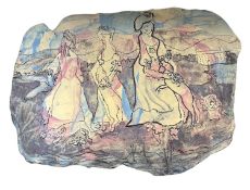
Keine Abbildung Los 49 Ann Froshaug (British, 20th century). "The Three Graces", acrylic washed crank clay, 30x42cm. 49Ann Froshaug (British, 20th century). "The Three Graces", acrylic washed crank clay, 30x42cm. Keys Fine Art Auctioneers Ann Froshaug (British, 20th century). "The Three Graces", acrylic washed crank clay, 30x42cm. Auf die Merkliste Live
Keine Abbildung Los 108 After Christopher Saxton and Philip Lea, a hand-coloured engraved map of 'Glocestershire' [sic], 108After Christopher Saxton and Philip Lea, a hand-coloured engraved map of 'Glocestershire' [sic], W&H Peacock Auctioneers & Valuers After Christopher Saxton and Philip Lea,a hand-coloured engraved map of 'Glocestershire' [sic],image 38 x 49 cm Auf die Merkliste Live
Keine Abbildung Los 109 After Pieter van der Aa (Dutch, 1659-1733), 'Latium Campania et Samnium cum Forum Circum 109After Pieter van der Aa (Dutch, 1659-1733), 'Latium Campania et Samnium cum Forum Circum W&H Peacock Auctioneers & Valuers After Pieter van der Aa (Dutch, 1659-1733),'Latium Campania et Samnium cum Forum Circum Adjacentibus Regionibus',hand-coloured engraved map,image ... Auf die Merkliste Live
Keine Abbildung Los 111 After S. Bellin, 'Carte Du Comté De Kent Et Du Pas De Calais', hand-coloured engraved map, image 111After S. Bellin, 'Carte Du Comté De Kent Et Du Pas De Calais', hand-coloured engraved map, image W&H Peacock Auctioneers & Valuers After S. Bellin,'Carte Du Comté De Kent Et Du Pas De Calais',hand-coloured engraved map,image 60 x 90 cm Auf die Merkliste Live
Keine Abbildung Los 114 A needlework map of Engalnd & Wales by Lucy Elizabeth Depeat, aged 9, 1890, image 73 x 73 cm, 114A needlework map of Engalnd & Wales by Lucy Elizabeth Depeat, aged 9, 1890, image 73 x 73 cm, W&H Peacock Auctioneers & Valuers A needlework map of Engalnd & Wales by Lucy Elizabeth Depeat, aged 9, 1890, image 73 x 73 cm, together with another similar map (2) Auf die Merkliste Live
Keine Abbildung Los 103 Rare Antique Georgian Cartographer’s Étui, Navigation Map Drafting Kit, Original 1760-1790 103Rare Antique Georgian Cartographer’s Étui, Navigation Map Drafting Kit, Original 1760-1790 Three Bridges Auction House Rare Antique Georgian Cartographer’s Étui, Navigation Map Drafting Kit, Original 1760-1790 together with the Captain Hook Magnifier with original ... Auf die Merkliste Live
Keine Abbildung Los 171 Early 19th century hand coloured map by James Knox C1821. Frame- 73x88cm 171Early 19th century hand coloured map by James Knox C1821. Frame- 73x88cm Three Bridges Auction House Early 19th century hand coloured map by James Knox C1821. Frame- 73x88cm Auf die Merkliste Live
Keine Abbildung Los 339 Abraham Ortelius (1527-1598) 1601 Original Copperplate map of Burgundy Details to the reverse side 339Abraham Ortelius (1527-1598) 1601 Original Copperplate map of Burgundy Details to the reverse side Three Bridges Auction House Abraham Ortelius (1527-1598) 1601 Original Copperplate map of Burgundy Details to the reverse side of the map. Frame- 47.5x60cm Auf die Merkliste Live
Keine Abbildung Los 860 Leighs Road Book of England and Wales, London 1887 and two other maps in slip cases depicting 860Leighs Road Book of England and Wales, London 1887 and two other maps in slip cases depicting John Nicholson's Leighs Road Book of England and Wales, London 1887 and two other maps in slip cases depicting Glasgow and the Environs. Auf die Merkliste Live
Keine Abbildung Los 84 Selection of eleven bottles of commemoratives ales 84Selection of eleven bottles of commemoratives ales Sutton Hill Farm Country Auctions Selection of eleven bottles of commemoratives ales Auf die Merkliste Live
Keine Abbildung Los 5008 Miniature tabletop globe 5008Miniature tabletop globe W&H Peacock Auctioneers & Valuers Miniature tabletop globe Auf die Merkliste Live
Keine Abbildung Los 5070 Print with terriors 5070Print with terriors W&H Peacock Auctioneers & Valuers Print with terriors Auf die Merkliste Live
Keine Abbildung Los 5120 Stone globe 5120Stone globe W&H Peacock Auctioneers & Valuers Stone globe Auf die Merkliste Live
Keine Abbildung Los 5121 Stone globe 5121Stone globe W&H Peacock Auctioneers & Valuers Stone globe Auf die Merkliste Live
Mindestpreis nicht eingehalten Keine Abbildung Los 48 Johann Babtiste Homann (1664 - 1724, Nürnberg) - Landkarte Kaspisches Meer und Kamtschatka, um 1720 48Johann Babtiste Homann (1664 - 1724, Nürnberg) - Landkarte Kaspisches Meer und Kamtschatka, um 1720 Wersching Auktionen Johann Babtiste Homann (1664 - 1724, Nürnberg) - Landkarte Kaspisches Meer und Kamtschatka, um 1720Mare Caspium altera Kamtzadaliam seu Terram Jed... Auf die Merkliste Timed
Keine Abbildung Los 244 AN OTTOMAN PRINTED VIEW OF AL-MASJID AL-HARAM, 20TH CENTURY 244AN OTTOMAN PRINTED VIEW OF AL-MASJID AL-HARAM, 20TH CENTURY Oriental Art Auctions 48 by 60 cm. Auf die Merkliste Live
Keine Abbildung Los 446 A PRINTED VIEW OF THE PRAYERS AROUND THE KABAA, FRANCE 19TH-EARLY 20TH CENTURY 446A PRINTED VIEW OF THE PRAYERS AROUND THE KABAA, FRANCE 19TH-EARLY 20TH CENTURY Oriental Art Auctions Coloured print on paper, depicting prayers around the Kabaa in al-Masjid al-Haram. 47 by 37 cm. 40 by 30 cm. Auf die Merkliste Live
Mindestpreis nicht eingehalten Keine Abbildung Los 6 Up at the O2 Family Climb Experience for 2 Adults and 2 Children - Bid for an unforgettable 6Up at the O2 Family Climb Experience for 2 Adults and 2 Children - Bid for an unforgettable Bamfords Auctioneers & Valuers Up at the O2 Family Climb Experience for 2 Adults and 2 Children - Bid for an unforgettable adventure! Climb the iconic O2 Arena and enjoy breatht... Auf die Merkliste Timed
Mindestpreis nicht eingehalten Keine Abbildung Los 11 The Ship Inn, Red Wharf Bay Anglesey £100 voucher - Enjoy £100 to spend at The Ship Inn, a 11The Ship Inn, Red Wharf Bay Anglesey £100 voucher - Enjoy £100 to spend at The Ship Inn, a Bamfords Auctioneers & Valuers The Ship Inn, Red Wharf Bay Anglesey £100 voucher - Enjoy £100 to spend at The Ship Inn, a stunning seaside pub overlooking Red Wharf Bay. Famous ... Auf die Merkliste Timed
Mindestpreis nicht eingehalten Keine Abbildung Los 58 Newly renovated, not yet on the market holiday home in Anglesey Located on the inland coast in 58Newly renovated, not yet on the market holiday home in Anglesey Located on the inland coast in Bamfords Auctioneers & Valuers Newly renovated, not yet on the market holiday home in Anglesey Located on the inland coast in Anglesey, Wales. This 2 bed bungalow would be avai... Auf die Merkliste Timed
Mindestpreis nicht eingehalten Keine Abbildung Los 120 A large quantity of early 20th century Ordnance Survey maps, to include Carmarthen, St. David's & 120A large quantity of early 20th century Ordnance Survey maps, to include Carmarthen, St. David's & 1818 Auctioneers A large quantity of early 20th century Ordnance Survey maps, to include Carmarthen, St. David's & Cardigan, Brecon & Llandovery, Abergavenny, Glou... Auf die Merkliste Timed
Mindestpreis nicht eingehalten Keine Abbildung Los 132 Two boxes containing various vintage Ordnance Survey maps, to include Loch Lomond, Bradford, 132Two boxes containing various vintage Ordnance Survey maps, to include Loch Lomond, Bradford, 1818 Auctioneers Two boxes containing various vintage Ordnance Survey maps, to include Loch Lomond, Bradford, Bolton ect, over 100 Auf die Merkliste Timed
Mindestpreis nicht eingehalten Keine Abbildung Los 170 A group of 7 blue binders holding various ordnance survey maps of Great Britain, (7) 170A group of 7 blue binders holding various ordnance survey maps of Great Britain, (7) 1818 Auctioneers A group of 7 blue binders holding various ordnance survey maps of Great Britain, (7) Auf die Merkliste Timed
Mindestpreis nicht eingehalten Keine Abbildung Los 190 Two boxes containing various Ordnance Survey maps of the UK, to include Preston and Blackpool, 190Two boxes containing various Ordnance Survey maps of the UK, to include Preston and Blackpool, 1818 Auctioneers Two boxes containing various Ordnance Survey maps of the UK, to include Preston and Blackpool, Askrigg & Settle and Selkirk, over 100 maps Auf die Merkliste Timed
Mindestpreis nicht eingehalten Keine Abbildung Los 663 North Eastern Railway Plans & Sections Session 1889, Sheet No 1 & 2, Railway No 2, No 3, 663North Eastern Railway Plans & Sections Session 1889, Sheet No 1 & 2, Railway No 2, No 3, 1818 Auctioneers North Eastern Railway Plans & Sections Session 1889, Sheet No 1 & 2, Railway No 2, No 3, Additional Lines, Land to be Taken, Land on Blyth and Tyn... Auf die Merkliste Timed
Keine Abbildung Los 370 A beautiful signed limited edition print by Jeremy King, Punting on the Cambridge river, 241 of 250, 370A beautiful signed limited edition print by Jeremy King, Punting on the Cambridge river, 241 of 250, Cadmore Auctions Ltd A beautiful signed limited edition print by Jeremy King, Punting on the Cambridge river, 241 of 250, frame size 81 x 62cm Auf die Merkliste Live
Mindestpreis nicht eingehalten Keine Abbildung Los 84 A collection of three possibly 17th century engraved and hand coloured maps of Surrey by John Norden 84A collection of three possibly 17th century engraved and hand coloured maps of Surrey by John Norden Criterion Auctioneers Ltd A collection of three possibly 17th century engraved and hand coloured maps of Surrey by John Norden & William Kip, John Speed, and Michael Drayto... Auf die Merkliste Timed
Mindestpreis nicht eingehalten Keine Abbildung Los 86 Two hand coloured and engraved maps to include one possibly late 17th century titled 'The Road 86Two hand coloured and engraved maps to include one possibly late 17th century titled 'The Road Criterion Auctioneers Ltd Two hand coloured and engraved maps to include one possibly late 17th century titled 'The Road from London to Portsmouth in com Southamp.' by John... Auf die Merkliste Timed
Mindestpreis nicht eingehalten Keine Abbildung Los 87 A collection of three possibly 17th century and later hand coloured maps of Esher and Surrey by G.R. 87A collection of three possibly 17th century and later hand coloured maps of Esher and Surrey by G.R. Criterion Auctioneers Ltd A collection of three possibly 17th century and later hand coloured maps of Esher and Surrey by G.R. Haybittle, John Speed, and Thomas Moule respe... Auf die Merkliste Timed
Mindestpreis nicht eingehalten Keine Abbildung Los 133 A Tannoy sub woofer. Disclaimer: electrical items are sold as untested and without guarantee. 133A Tannoy sub woofer. Disclaimer: electrical items are sold as untested and without guarantee. Humbert & Ellis Ltd A Tannoy sub woofer. Disclaimer: electrical items are sold as untested and without guarantee. Auf die Merkliste Timed
Mindestpreis nicht eingehalten Keine Abbildung Los 8 After Robert McInnes (1838), fine textured Selby print portrait of Lt. Col. James Moray 8After Robert McInnes (1838), fine textured Selby print portrait of Lt. Col. James Moray Barry L Hawkins After Robert McInnes (1838), fine textured Selby print portrait of Lt. Col. James Moray Auf die Merkliste Timed
Mindestpreis nicht eingehalten Keine Abbildung Los 15 England V West Indies ltd edition print, Trent Bridge 1995 by Jocelyn Galsworthy, signed and 15England V West Indies ltd edition print, Trent Bridge 1995 by Jocelyn Galsworthy, signed and Barry L Hawkins England V West Indies ltd edition print, Trent Bridge 1995 by Jocelyn Galsworthy, signed and numbered in margin 64x46cm Auf die Merkliste Timed
Keine Abbildung Los 31 A reproduction map marked Plano del Purto together with two further prints on board backs 31A reproduction map marked Plano del Purto together with two further prints on board backs Keys Fine Art Auctioneers A reproduction map marked Plano del Purto together with two further prints on board backs Auf die Merkliste Live
Keine Abbildung Los 299 C1720 LATIUM CAMPANIA ET SAMNIUM - MAP OF ANCIENT ITALY 299C1720 LATIUM CAMPANIA ET SAMNIUM - MAP OF ANCIENT ITALY Auctioneum Ltd - East Bristol & Bath C1720 Latium Campania et Samnium by AA, Pieter van der - Map engraving of ancient Italy with later colouring, framed and glazed. Complete with cer... Auf die Merkliste Live
Keine Abbildung Los 303 Yachting Interest - Modern coloured print Three Cheers for America 303Yachting Interest - Modern coloured print Three Cheers for America Keys Fine Art Auctioneers Yachting Interest - Modern coloured print Three Cheers for America Auf die Merkliste Live
Keine Abbildung Los 383 1967 PRINT OF SAXTON'S MAP OF SOMERSET, 1575 BY TAYLOWE LIMITED 3831967 PRINT OF SAXTON'S MAP OF SOMERSET, 1575 BY TAYLOWE LIMITED Auctioneum Ltd - East Bristol & Bath 1967 coloured print of Saxton's Map of Somerset, 1575 by Taylowe Limited. Framed and glazed, measuring approx. 53.5cm x 65.5cm. Auf die Merkliste Live
Keine Abbildung Los 449 An antique map of Scotland, dated 1821 and engraved for Dr Playfair's Atlas, published by Macredie 449An antique map of Scotland, dated 1821 and engraved for Dr Playfair's Atlas, published by Macredie Churchill Auctions An antique map of Scotland, dated 1821 and engraved for Dr Playfair's Atlas, published by Macredie Skelly & Co of Edinburgh, 1821, 69cm x 58cm Auf die Merkliste Live
Keine Abbildung Los 450 An antique map of Stirlingshire in Scotland, believed to be 1832 edition published by John 450An antique map of Stirlingshire in Scotland, believed to be 1832 edition published by John Churchill Auctions An antique map of Stirlingshire in Scotland, believed to be 1832 edition published by John Thomson. Drawn by W Johnson. Engraved by Sidney Hall. I... Auf die Merkliste Live
Keine Abbildung Los 462 Two pub related artworks to inc John Vince signed Scottish Lion and verse cut out and a Whitbread 462Two pub related artworks to inc John Vince signed Scottish Lion and verse cut out and a Whitbread Churchill Auctions Two pub related artworks to inc John Vince signed Scottish Lion and verse cut out and a Whitbread Ales advertising print, largest 77cm x 47cm Auf die Merkliste Live
Keine Abbildung Los 487 Three framed maps to incl a likely 19th century 'Places of the Meeting of Foxhounds' in 487Three framed maps to incl a likely 19th century 'Places of the Meeting of Foxhounds' in Churchill Auctions Three framed maps to incl a likely 19th century 'Places of the Meeting of Foxhounds' in Buckinghamshire by J & C Walker from the Hobson's Foxhunti... Auf die Merkliste Live
Keine Abbildung Los 495 An antique map of Buckinghamshire by Robert Morden, hand colouring, 46cm x 41cm 495An antique map of Buckinghamshire by Robert Morden, hand colouring, 46cm x 41cm Churchill Auctions An antique map of Buckinghamshire by Robert Morden, hand colouring, 46cm x 41cm Auf die Merkliste Live
Keine Abbildung Los 496 A large vintage framed Ordnance Survey map depicting the Chilterns, the map dated 1932 lower 496A large vintage framed Ordnance Survey map depicting the Chilterns, the map dated 1932 lower Churchill Auctions A large vintage framed Ordnance Survey map depicting the Chilterns, the map dated 1932 lower right, in ebonised frame, 85cm x 79cm Auf die Merkliste Live
Keine Abbildung Los 497 Six assorted maps mainly of Buckinghamshire and the Home Counties, a reproduction John Speed map 497Six assorted maps mainly of Buckinghamshire and the Home Counties, a reproduction John Speed map Churchill Auctions Six assorted maps mainly of Buckinghamshire and the Home Counties, a reproduction John Speed map of Buckinghamshire and five other maps all believ... Auf die Merkliste Live


![After Christopher Saxton and Philip Lea, a hand-coloured engraved map of 'Glocestershire' [sic],](https://portal-images.azureedge.net/auctions-2025/whpav12190/images/c43f84c3-fa6b-42c4-bd5f-b2c301157fc5.jpg?h=175)