Affinez votre recherche
Filtered by:
- Catégorie
- Liste
- Grille
A subscription to the Price Guide is required to view results for auctions ten days or older. Click here for more information
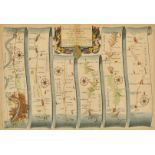

John Ogilby, circa 1698, The Road from London to St. Davids in com. Pembroke, circa 1698, hand
John Ogilby, circa 1698, The Road from London to St. Davids in com. Pembroke, circa 1698, hand coloured engraved strip road map, sheet 14, 12" x 1...
Johannes Blaeu, 17th Century, 'Middle-Sexia', hand coloured and outlined, 15" x 16".
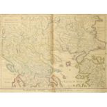
Marco Secznagel, 'Salisburgensis Iurisdictionis', hand coloured 17th Century map of the region of
Marco Secznagel, 'Salisburgensis Iurisdictionis', hand coloured 17th Century map of the region of Salzburg, published by Ortelius, 15.25" x 18".
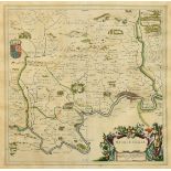
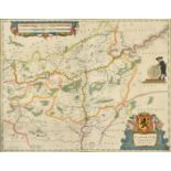
W & J Blaeu, 'Ducatus Limburgum Auctore Aegidio Martini', a hand-coloured 17th Century engraved map,
W & J Blaeu, 'Ducatus Limburgum Auctore Aegidio Martini', a hand-coloured 17th Century engraved map, 15.25 x 19.75". ...[more]
A group of 5 18th Century maps of Ancient European States, published by Laurie and Whittle, outline coloured, 22" x 29.5", rolled. (5).
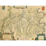
'Namurcum Comitatus Auctore Iohann Surhonio', after Blaeu, a 17th Century outline coloured map,
'Namurcum Comitatus Auctore Iohann Surhonio', after Blaeu, a 17th Century outline coloured map, 16" x 20.5", (unframed).
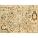
Willem Blaeu, 'Fossa Sanctae Mariae, quae et Eugeniana Dicitur vulgo de Nieuwe Grift', a hand-
Willem Blaeu, 'Fossa Sanctae Mariae, quae et Eugeniana Dicitur vulgo de Nieuwe Grift', a hand-coloured 17th Century map, 15" x 20", (unframed).
William Blaeu, 'La Principaut d'Orange et Comtat de Venaissin', a hand coloured 17th Century map,
William Blaeu, 'La Principaut d'Orange et Comtat de Venaissin', a hand coloured 17th Century map, 15" x 19.5", (unframed).
A group of four 18th Century French maps of the four Continents, with a green wash and outline
A group of four 18th Century French maps of the four Continents, with a green wash and outline colouring, 12" x 18", (unframed), (4).

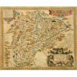
Robert Morden, a hand-coloured map of Shropshire, 14" x 17", unframed, along with a further hand
Robert Morden, a hand-coloured map of Shropshire, 14" x 17", unframed, along with a further hand coloured map of Shropshire published by Pigot and...
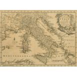
A 19th Century Map of Italy, 8" x 11".
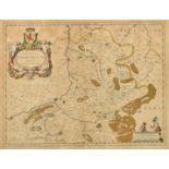
Episcopatus Dunelmensis, vulgo the Bishoprick of Durham, by Robert Morden, outline coloured, 18th
Episcopatus Dunelmensis, vulgo the Bishoprick of Durham, by Robert Morden, outline coloured, 18th Century, 14.5" x 17".