Filtered by:
- Sale Section
- Liste
- Grille
A subscription to the Price Guide is required to view results for auctions ten days or older. Click here for more information
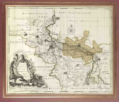

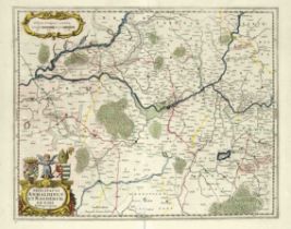
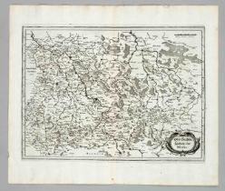
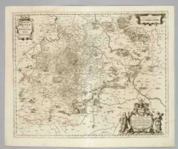
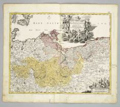
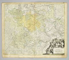
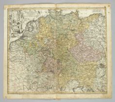
Historical Map of Merseburg and Surroundings to Leipzig and Halle, ''Accurater Geometrischer General
Historical Map of Merseburg and Surroundings to Leipzig and Halle, ''Accurater Geometrischer General Ris des Stiffts Merseburg (...)'', copper eng...
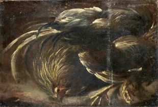
Italian painter of the 17th century, Fowl (cockfight?), fragment, oil on canvas, unsigned, rubbed,
Italian painter of the 17th century, Fowl (cockfight?), fragment, oil on canvas, unsigned, rubbed, bumped and retouched, 36 x 53 cm
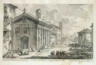
Giovanni Battista Piranesi (1720-1778), ''Veduta del Tempio della Fortuna virile'', etching from the
Giovanni Battista Piranesi (1720-1778), ''Veduta del Tempio della Fortuna virile'', etching from the series of ''Vedute di Roma'' c. 1758, vertica...
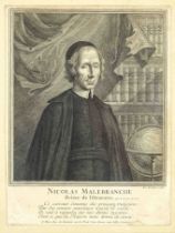
Pierre de Rochefort (ca.1673-?), Portrait of the French philosopher and clergyman Nicolas Malebranche, copperplate engraving with written margin, ...
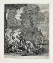
Dancker Danckerts (1634-1666) after Cornelis Holsteijn (1618-ca.1658), Bathers, etching on laid
Dancker Danckerts (1634-1666) after Cornelis Holsteijn (1618-ca.1658), Bathers, etching on laid paper, 17th century print, Latin script margin, pa...
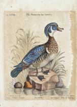
Ornithology - 10 etchings with depictions of exotic birds from two different publications around
Ornithology - 10 etchings with depictions of exotic birds from two different publications around 1800, 4 color etchings by Langlois for ''Histoire...
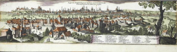
Constantinople - View of Constantinople ''Prospect der Türckisch Haupt- und Residentz-Stadt
Constantinople - View of Constantinople ''Prospect der Türckisch Haupt- und Residentz-Stadt Stambul...'', col. Copper engraving with legend, trimm...
Italian master, probably 17th century, the Christ monogram appears to St. Bernardine of Siena,
Italian master, probably 17th century, the Christ monogram appears to St. Bernardine of Siena, accompanied by a putto, pencil drawing on laid pape...
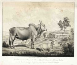
Sheep and Breeding Bulls from the Herds of His Majesty the King of Württemberg, 4 lithographs from
Sheep and Breeding Bulls from the Herds of His Majesty the King of Württemberg, 4 lithographs from the rare series: ''Zuchtstier von dem Stamme de...
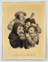
François Delpech (1778-1825) after Louis Léopold Boilly (1761-1845), two color lithographs from
François Delpech (1778-1825) after Louis Léopold Boilly (1761-1845), two color lithographs from the famous series of caricatures after Boilly, ''A...
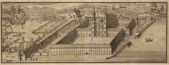
Historical view of the Tegernsee monastery in Bavaria, large-format copper engraving from two
Historical view of the Tegernsee monastery in Bavaria, large-format copper engraving from two plates, general view of the Benedictine monastery by...
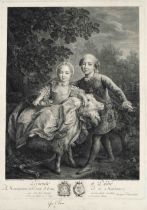
Jacques Firmin Beauvarlet (1731-1797) after François Hubert Drouais (1727-1775), ''Le Comte d'Artois
Jacques Firmin Beauvarlet (1731-1797) after François Hubert Drouais (1727-1775), ''Le Comte d'Artois et Madame Clotilde enfants'', copperplate eng...
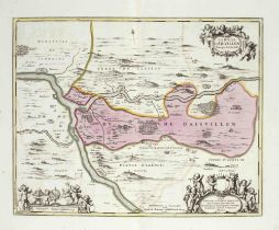
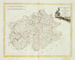
Historical map of Duchy d'Aiguillon in the department Lot-et-Garonne, ''Le Duche D'Aiguillon'',
Historical map of Duchy d'Aiguillon in the department Lot-et-Garonne, ''Le Duche D'Aiguillon'', partly col. Copper engraving by Schenk and Valk c....
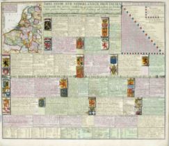
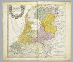
Netherlands -- ''Tafel van de XVII Nederlandze Provincien'', copper engraving map of the Netherlands
Netherlands -- ''Tafel van de XVII Nederlandze Provincien'', copper engraving map of the Netherlands with coats of arms and descriptions of the in...
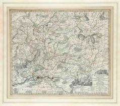
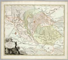
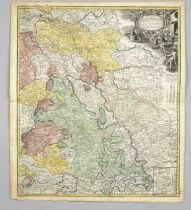
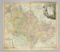
Historical map of the district of Wurzen and Oschatz in Saxony, copper engraving map around 1720,
Historical map of the district of Wurzen and Oschatz in Saxony, copper engraving map around 1720, unknown publisher, border col. Map with detailed...
Historical map of Lombardy ''Ducatus Mediolani...'', copper engraving map by Homann, Nuremberg
Historical map of Lombardy ''Ducatus Mediolani...'', copper engraving map by Homann, Nuremberg around 1720, partially border and area colored. Det...
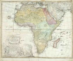
Historical continental map of Africa, ''Africa Secundum legitimas Projectionis Stereographicae
Historical continental map of Africa, ''Africa Secundum legitimas Projectionis Stereographicae regulas'', border and area col. Copper engraved map...
Historical map of Anhalt and Magdeburg, ''Principatus Anhaldinus et Magdeburgensis...'', partly col.
Historical map of Anhalt and Magdeburg, ''Principatus Anhaldinus et Magdeburgensis...'', partly col. Copper engraving by Janssonius c. 1650, cente...
Historical map of the area around Wetterau in Hesse, ''Wetteravia cum omnibus inclusis Principatibus, Comitatibus, Dominiis et Praefecturis...'', ...
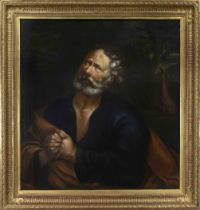
Italian artist of the 18th century, ''Der reuige Petrus'', with tears in his eyes the apostle
Italian artist of the 18th century, ''Der reuige Petrus'', with tears in his eyes the apostle repents his betrayal of Jesus, while the cock crows ...
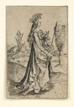
Master MZ, after, 16th century copy, ''Die heilige Ursula'', copperplate engraving on laid paper,
Master MZ, after, 16th century copy, ''Die heilige Ursula'', copperplate engraving on laid paper, with narrow margin around the framing line, mono...
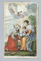
Unknown 17th century artist, Mary with the Christ Child and St. Catherine, copper engraving on
Unknown 17th century artist, Mary with the Christ Child and St. Catherine, copper engraving on vellum, allt col., inscribed in the plate ''S. Cath...
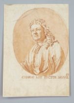
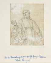
Unknown artist of the 17th/18th century, bust portrait of the painter Johann Carl Loth, red chalk on
Unknown artist of the 17th/18th century, bust portrait of the painter Johann Carl Loth, red chalk on laid paper, old mounted on paper, inscribed '...
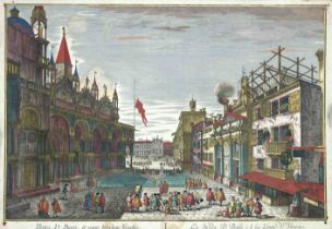
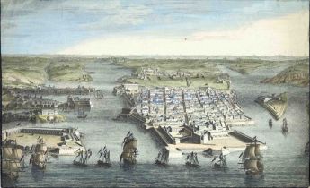
Mixed lot of 4 18th century peep-box sheets: 3 views of Venice, 1 view of Rome, copperplate
Mixed lot of 4 18th century peep-box sheets: 3 views of Venice, 1 view of Rome, copperplate engravings with screen border, old col., age defects, ...
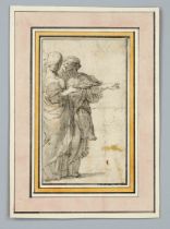
Unknown 17th century artist, antique-style figure study, black chalk and pen and brown ink on paper,
Unknown 17th century artist, antique-style figure study, black chalk and pen and brown ink on paper, in old collector's mount, 16 x 9 cm, 22.5 x 1...
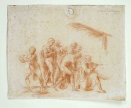
Unknown artist of the 17th/18th century, figure study (for an Adoration of the Christ Child?), red
Unknown artist of the 17th/18th century, figure study (for an Adoration of the Christ Child?), red chalk on paper, inscribed ''scuola fiorentiina'...
Collection of 5 views in copper engravings and etchings from the 18th century, 4 x colored, mostly
Collection of 5 views in copper engravings and etchings from the 18th century, 4 x colored, mostly peep-box sheets, including views of Amsterdam, ...
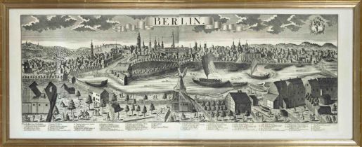
Johann Friedrich Probst (1721-1781), after, ''Berlin'', large panoramic view with detailed legend,
Johann Friedrich Probst (1721-1781), after, ''Berlin'', large panoramic view with detailed legend, copper engraving (heliogravure?) from two plate...
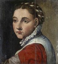
Italian School of the 16th / early 17th century, bust portrait of a woman with tied-up hair and
Italian School of the 16th / early 17th century, bust portrait of a woman with tied-up hair and ruff, oil on wood, unsigned, backed and retouched ...
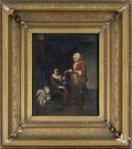
Genre painter 17th/18th century, In the nursery, oil/wood, unsigned, verso inscribed van Gael, 25.
Genre painter 17th/18th century, In the nursery, oil/wood, unsigned, verso inscribed van Gael, 25.5 x 21 cm, framed 44 x 39 cm
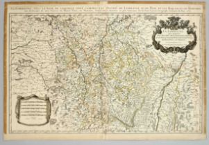
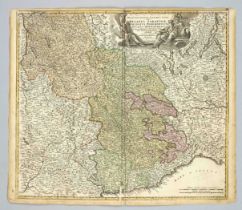
Historical map of Lorraine -- ''La Lorraine, sous le nom de laquelle, sont compris les duchés de
Historical map of Lorraine -- ''La Lorraine, sous le nom de laquelle, sont compris les duchés de Lorraine et de Bar, et les baillages du Temporel ...
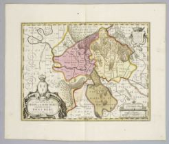
Historical map of the Principality of Sedan and Raucourt, ''La Souveraineté de Sedan et de Raucourt et la Prevosté de Doncheri [...]'', colored co...
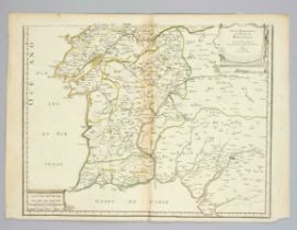
Historical map of Portugal -- ''Parte Meridional Do Reyno De Portugal Por N. Sanson d'Abbeville
Historical map of Portugal -- ''Parte Meridional Do Reyno De Portugal Por N. Sanson d'Abbeville Geographo ordinario del'Rey Christianissimo 1679 E...
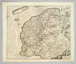
Historical map of Friesland, ''Tabula Comitatus Frisiae'', partly col. Copper engraving by F. de
Historical map of Friesland, ''Tabula Comitatus Frisiae'', partly col. Copper engraving by F. de Wit, c. 1690, small side map with the North Sea i...
Historical map of the Upper Saxon Imperial District, ''Pars Meridionale del Circolo dell' Alta
Historical map of the Upper Saxon Imperial District, ''Pars Meridionale del Circolo dell' Alta Sassonia [...]'', border colored copper engraving b...
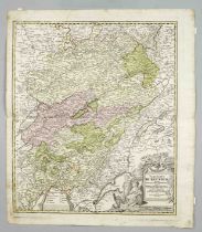
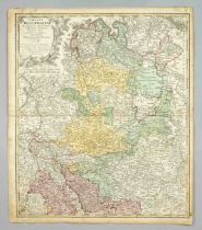
Historical map of Upper Saxony with Laußnitz and Meissen, copper engraving by Merian around 1650,
Historical map of Upper Saxony with Laußnitz and Meissen, copper engraving by Merian around 1650, title cartouche ''OberSachsen. Laußnitz and Meis...
Two historical maps of Belgium and France -- ''Gallia Belgica'' and ''Gallia Transalpina'', two
Two historical maps of Belgium and France -- ''Gallia Belgica'' and ''Gallia Transalpina'', two colored copper engravings, by Weigel in Nuremberg ...
Historical map of the region around Mindelheim, ''Protoparchiae Mindelhemensis nova tabula geographica....'', colored copperplate engraving, by Ho...
Historical map of the Upper Saxon Imperial District, ''Le Cercle de Haute Saxe ou sont compris Le
Historical map of the Upper Saxon Imperial District, ''Le Cercle de Haute Saxe ou sont compris Le Duché et Esclectorat de Saxe [...]'', colored co...
Historical map of Brandenburg and the Upper Saxon Imperial District, ''Circulus Saxoniae Superioris [...]'', colored copperplate engraving bnei Va...
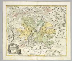
Historical map of the Margraviate of Meissen, ''Marchionatus Misniae una cum Voitlandia'', copperplate engraving by Janssonius after Hondius with ...
Historical map of Stolberg in the Harz Mountains, ''Comitatus Stolbergici...'', partly col. Copper
Historical map of Stolberg in the Harz Mountains, ''Comitatus Stolbergici...'', partly col. Copper engraving by Homann Erben in Nuremberg around 1...
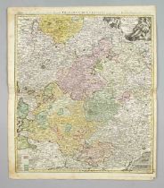
Historical map of Thuringia with Erfurt in the center, ''Nova Territorii Erfordiensis...'', partly
Historical map of Thuringia with Erfurt in the center, ''Nova Territorii Erfordiensis...'', partly col. Copper engraving by Homann in Nuremberg c....
Historical map of Burgundy / France, ''Comitatus Burgundiae...'', partly col. Copper engraving by
Historical map of Burgundy / France, ''Comitatus Burgundiae...'', partly col. Copper engraving by Homann in Nuremberg c. 1740, centerfold, backed ...
Historical map of Brandenburg and Pomerania, ''Tabula Marchionatus Brandenburgici et Ducatus
Historical map of Brandenburg and Pomerania, ''Tabula Marchionatus Brandenburgici et Ducatus Pomeraniae...'', partly col. Copper engraving by Homa...
Historical map of Jülich and the Rhineland, ''Ducatus Iulica & Bergensis...'', partly col. Copper
Historical map of Jülich and the Rhineland, ''Ducatus Iulica & Bergensis...'', partly col. Copper engraved map by Homann Erben around 1740, center...
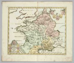
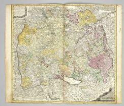
Historical map of Northwest Germany, 'Circuli Westphaliae...', col. Copper engraving by Homann Erben
Historical map of Northwest Germany, 'Circuli Westphaliae...', col. Copper engraving by Homann Erben in Nuremberg around 1760, from Aachen in the ...
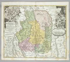
Historical map of the Franconian Circle, ''Circuli Franconiae'', ''Erster und gröster Theil des
Historical map of the Franconian Circle, ''Circuli Franconiae'', ''Erster und gröster Theil des gantzen Hochlöblichen Franckischen Craisses [...]'...
Historical map of the archbishopric of Trier ''Mosellae Fluminis Tabula Specialis in qua Archiepiscopatus et Electoratus Trevirensis'', partly col...
Historical map of the course of the Rhine from Rastatt to St. Goar, ''Palatinatus ad Rhenum...'',
Historical map of the course of the Rhine from Rastatt to St. Goar, ''Palatinatus ad Rhenum...'', partly co. Copper engraving by Homann in Nurembe...
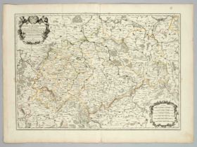
Historical map of Baden-Württemberg, ''Circuli Sveviae...'', partly col. Copper engraving by
Historical map of Baden-Württemberg, ''Circuli Sveviae...'', partly col. Copper engraving by Homann Erben 1743, marginal defects, partly backed, s...
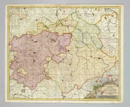
Historical map of Austria -- ''Circulus Austriacus ...'', the Austrian Circle with the Duchies of
Historical map of Austria -- ''Circulus Austriacus ...'', the Austrian Circle with the Duchies of Carniola, Carinthia, Styria and the County of Ty...
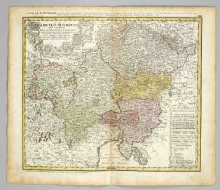
Historical map of Germany -- ''Imperii Romano Germanici...'', partly col. Copper engraving by Homann
Historical map of Germany -- ''Imperii Romano Germanici...'', partly col. Copper engraving by Homann in Nuremberg c. 1720, centerfold, browned, st...
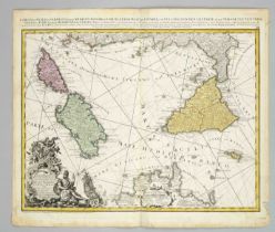
Historical map of Sicily and Sardinia -- ''Li Regni di Sicilia, e Sardegna, colle Adiacent Isole
Historical map of Sicily and Sardinia -- ''Li Regni di Sicilia, e Sardegna, colle Adiacent Isole di Corsica, Elba, Malta, e Liparee, o di Vulcano,...
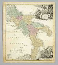
Historical map of southern Italy, ''Totius Regni Neapolis'', partly col. Copper engraving by
Historical map of southern Italy, ''Totius Regni Neapolis'', partly col. Copper engraving by Homann in Nuremberg around 1710, with figurative titl...
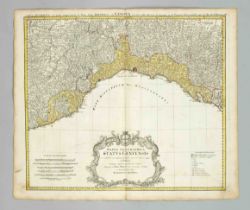
Historical map of the Gulf of Naples -- ''Geographica Status Genuensis ...'', partly col. Copper
Historical map of the Gulf of Naples -- ''Geographica Status Genuensis ...'', partly col. Copper engraving by Homann Erben around 1750, browned in...
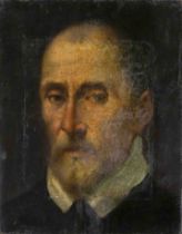
Unknown painter, probably Italy 16th century, Portrait of a nobleman with beard and white collar,
Unknown painter, probably Italy 16th century, Portrait of a nobleman with beard and white collar, oil on canvas, relined, restored and heavily ret...
Historical map of the Gulf of Genoa, ''Ducatus Sabaudiae...'', partly col. Copper engraving by
Historical map of the Gulf of Genoa, ''Ducatus Sabaudiae...'', partly col. Copper engraving by Homann in Nuremberg c. 1730, lack of conservation, ...
Historical map of Belgium, ''Belgium Foederatum...'', partly col. Copper engraving by Homann Erben
Historical map of Belgium, ''Belgium Foederatum...'', partly col. Copper engraving by Homann Erben 1748, centerfold, browned, spotty, sheet measur...
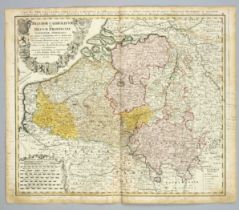
Historical map of Belgium, ''Belgium Catholicum seu Decem Provinciae Germaniae Inferioris ...'',
Historical map of Belgium, ''Belgium Catholicum seu Decem Provinciae Germaniae Inferioris ...'', colored copper engraving map published by Homanns...