Affinez votre recherche
Sale Section
Estimation
Catégorie
- Books, Manuscripts & Periodicals (397)
- Maps (128)
- Prints & Multiples (120)
- Arms, Armour & Militaria (11)
- Toys, Models & Dolls (11)
- Watercolours (6)
- Sculpture (4)
- Vintage Fashion (3)
- Collectables (2)
- Photographs (2)
- Sporting Memorabilia & Equipment (2)
- Taxidermy & Natural History (2)
- Islamic Works of Art (1)
- Oil, Acrylic paintings & Mixed Media (1)
- Russian Works of Art (1)
- Scientific Instruments (1)
- Stamps (1)
Creator / Brand
- Mercator (10)
- Blaeu (9)
- ACE Trains (6)
- Ortelius (6)
- Jane Austen (4)
- John Speed (4)
- Charles Williams (3)
- First World War (3)
- James Wyld (3)
- Rudyard Kipling (3)
- Thomas Rowlandson (3)
- Van Keulen (3)
- Boer War (2)
- Henry James (2)
- James Gillray (2)
- Roald Dahl (2)
- Beatrix Potter (1)
- Biba (1)
- Browning (1)
- Charles Dickens (1)
- Chaucer (1)
- Emma Roberts (1)
- England (1)
- George Cruickshank (1)
- George Morland (1)
- Guillaume Delisle (1)
- Harper Lee (1)
- Henry Alken (1)
- J. M. W. Turner (1)
- James Barry (1)
- John Cary (1)
- John Constable (1)
- John Moore (1)
- John Murray (1)
- Jonathan Swift (1)
- Joshua Reynolds (1)
- Lattre (1)
- Le Rouge (1)
- Lewis Carroll (1)
- Lord Byron (1)
- Pieter van der Aa (1)
- Robert Sayer (1)
- Scotland (1)
- Thomas Hardy (1)
- Thomas Kelly (1)
- Vanity Fair (1)
- Vatican (1)
- William Hogarth (1)
Item Type
- Map (126)
- Book (115)
- Folio (71)
- Lithograph (50)
- Letter (42)
- Engraving (31)
- Manuscript (27)
- Etching (17)
- Atlas (15)
- Journal (15)
- Portrait (12)
- Bible (11)
- Cartographers and Mapmakers (11)
- Carte (10)
- Dictionary (10)
- Game (10)
- Playing Card (10)
- 15th-18th Century Art (8)
- 19th-21st Century Art (8)
- Famous Author (8)
- Playing Cards (8)
- Figure (4)
- Militaria (4)
- Oleograph (4)
- Bag (3)
- Globe (3)
- Magazine (3)
- Manuscripts (3)
- Poetry (3)
- Road map (3)
- Road map (3)
- Suit (3)
- WW1 Militaria (3)
- Antique Arms (2)
- Badges, Medals & Pins (2)
- Manual (2)
- Military Medal (2)
- Photograph (2)
- Playing Cards (2)
- Rifle (2)
- Axe (1)
- Blunt (1)
- Blunt Weapons (1)
- Celestial Chart (1)
- Club (1)
- Compass (1)
- Encyclopedia (1)
- Folios (1)
- Football (1)
- Football Memorabilia (1)
- Football Teams & Brands (1)
- Hat (1)
- Knives and Blades (1)
- Medal (1)
- Military Uniform (1)
- Oil painting (1)
- Ordnance survey map (1)
- Periodical (1)
- Programme (1)
- Scissors (1)
- Sheet Music (1)
- Slip (1)
- Sport (1)
- Stamp (1)
- The Military Cross (1)
- Uniform (1)
- Womens Fashion (1)
- Woodblock (1)
- Liste
- Grille
A subscription to the Price Guide is required to view results for auctions ten days or older. Click here for more information
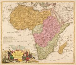

Africa. Homann (Johann Baptist), Totius Africae nova repraesentatio qua praeter diversos in ea status et regiones etiam origo Nili ..., published ...
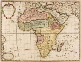
Africa. Covens (J. & Mortier P.), Carte D'Afrique Dressée pour l'Usage du Roy, par Guillaume DeLisle..., Amsterdam, circa 1730, engraved map with ...
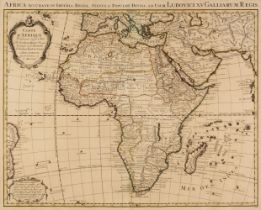
* Africa. De L'Isle (Guillaume), Carte D'Afrique Dressée pour l'usage du Roy..., Paris, 1722, engraved map with contemporary outline colouring and...
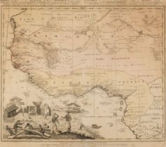
* Africa. Homann (Johann Baptiste, heirs of), Guinea propria nec non Nigritiae vel Terrae Nigrorum maxima pars..., Nuremberg, 1743, engraved map w...
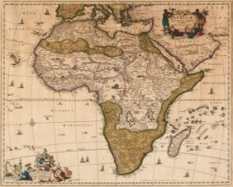
* Africa. Visscher (Nicolas), Africae Accurata Tabula ex officina, circa 1680, engraved map with contemporary wash colouring, slight oxidization t...
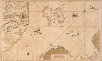
Arctic Ocean. Van Keulen (Johannes), Nieuwe Pascaart Inhoudende t'noorder Deel van Europa Synde seer Dienstigh Voorde Groenlandse en Moskovise Sch...
Arrowsmith (John). The London Atlas of Universal Geography exhibiting the Physical & Political Divisions of the Various Countries of the World, Co...
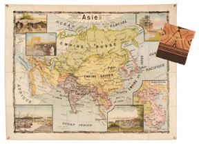
Asia. Bricon (J. & Lesot A.), Asie, Paris, circa 1910, colour lithographic wall map, sectionalised and laid on linen, five inset vignettes includi...
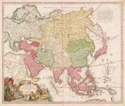
Asia. Homann (Johann Baptist), Asiae Recentissima Delineatio qua Status et Imperia Totius Orientis Unacum Orientalibus Indiis Exhibentur, Nurember...
![Astronomy. Astronomical Diagrams, London: James Reynolds, [1851]](https://portal-images.azureedge.net/auctions-2024/srdom10233/images/366ab1e1-80b4-4907-8e8c-b11e011dc36c.jpg?h=210)
Astronomy. Astronomical Diagrams (title on upper cover), London: James Reynolds, [1851], fourteen engraved plates on stiff card, with original col...
Atlases. A collection of 31 volumes, 19th century, British atlases, part atlases and part volumes, including examples by or after Sidney Hall, Sam...
Australasia & Oceania. Bonne (Rigobert & others), A collection of 20 charts, circa 1775, uncoloured engraved charts, including several from French...
Australasia. A collection of Eighteen maps, mostly 19th-century, including examples by or after Sydney Harbour Trust (publishers), Benard, Bonne, ...
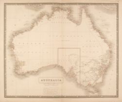
Australasia. A collection of forty maps, mostly 19th century, engraved and lithographic country and regional maps of Australasia and Oceania, incl...
Australasia. Allen (George), Large chart of the South Western Pacific,Laurie & Whittle, circa 1800
Australasia. Allen (George), To the Honorable Court of Directors of the United East India Company This Chart of the Western Part of the Pacific Oc...
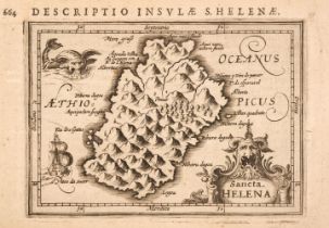
Bertius (Petrus). 12 maps of Africa and surrounding islands; Sancta Helena, Insula & Arx Mosambiqve, I. S. Lauretn sive Madagascar, Congo Regnum C...
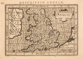
Bertius (Petrus). 13 maps of the British Isles; Anglia, Anglia Scotia et Hibernia, Magna Britannia, Scotia, Scotia Australis, Scotia Septentrion, ...
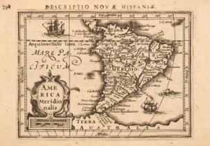
Bertius (Petrus). 6 maps of South America; America Meridionalis, Cerro de Potosi, Peru, Chili, Brasilia, and Magellanici Freti Delineatio [1616-37...
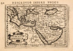
Bertius (Petrus). 6 maps of the Middle East; Turcicum Imperium, Ormus regnum, Arabia, Tabula Cananaeae and Natolia, Persicum Regnum, [1616-37], un...
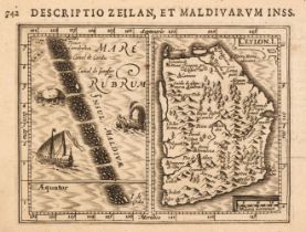
Bertius (Petrus). 7 maps of India; Malacca, Narsinga, Bengala, Ceylon, Cambaia, Malabar, Arachan & Pegv [1616-37], uncoloured engraved miniature m...
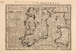
Bertius (Petrus). 7 maps of Ireland; Hibernia, Hibernia Septentr in qua Ultonia Connatia, Hibernia Austral in qua Momonia Lagenia, Lagenia, Udrone...
Bertius (Petrus). China and Iapan, [1616-37], 2 uncoloured engraved miniature maps, additional title in Latin above maps, slight marginal worming,...
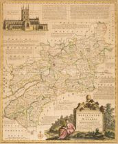
Birmingham. Beilby, Knott & Beilby (publishers), To the Right Honourable William Earl of Dartmouth, Viscount Lewisham &c. &c. the Zealous Promoter...
* Bowen (Emanuel). An Accurate Map of Gloucestershire Divided into Hundreds..., R. Sayer & J. Ryall, H. Overton, Carington Bowles, J. Bowles and H...
British County Maps. A collection of approximately 100 maps, 17th - 19th century, engraved British county maps, including examples by or after Mor...
British County Maps. A collection of approximately 50 maps, mostly 18th & 19th century, engraved and lithographic county, country and regional map...
British Isles. De Wit (Frederick), Novissima prae caeteris aliis accuratissima Regnorum Angliae Scotiae Hiberniae..., Amsterdam circa 1690, engrav...
British Isles. A collection of 29 maps, 17th - 19th century, engraved and lithographic regional, county and country maps, road maps, sea charts an...
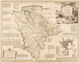
British Isles. A collection of eight maps, 17th - 19th century, including Mercator (Gerard & Hondius H.). Cornubia, Devonia, Somersetus, Dorcestri...
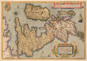
British Isles. Ortelius (Abraham), Angliae, Scotiae et Hiberniae sive Britannicar..., 1610 - 12
British Isles. Ortelius (Abraham), Angliae, Scotiae et Hiberniae sive Britannicar: Insularum Descriptio [1610 - 12], engraved map with contemporar...
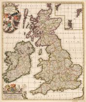
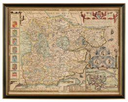
![British Isles. Speed (John), The Kingdome of Great Britaine and Ireland, [1676],](https://portal-images.azureedge.net/auctions-2024/srdom10233/images/15d22f8e-5371-4d7e-b6f2-b11e011ddcef.jpg?h=210)
British Isles. Speed (John), The Kingdome of Great Britaine and Ireland, published Thomas Bassett & Richard Chiswell, [1676], hand coloured engrav...
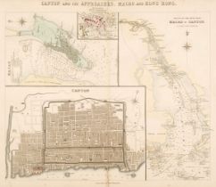
Canton. Stanford (Edward, publisher), Canton and its Approaches, Macao and Hong Kong, circa 1855
Canton. Stanford (Edward, publisher), Canton and its Approaches, Macao and Hong Kong, circa 1855, engraved map with contemporary hand-colouring, i...

Central Asia. Wyld (James), Wyld's Military Staff Map of Central Asia and Afghanistan, circa 1880
Central Asia. Wyld (James), Wyld's Military Staff Map of Central Asia and Afghanistan, circa 1880, lithographic map with contemporary outline colo...
Collins (Captain Greenville). Four Sea Charts. Dartmouth, Untitled chart of Southwest Cornwall and the Scilly Isles, Holy-Head [and] The Cheife Ha...
Composite World Atlas. D'Anville (Jean Baptiste), Atlas de Mr D'Anville, circa 1743-64, contemporary manuscript title and index, 26 engraved maps ...
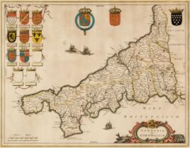
* Cornwall. Blaeu (Johannes), Cornubia sive Conwallia, Amsterdam, circa 1645, engraved map with contemporary outline colouring, decorative cartouc...
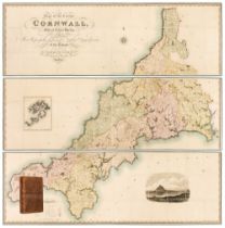
Cornwall. Greenwood (C. & J.), Map of the County of Cornwall from an Actual Survey, made in the Years 1826 & 1827, by C. & J. Greenwood. Most Resp...
![Cuba and the West Indies. Ortelius (Abraham), Culicanae Americae..., [1579 - 84],](https://portal-images.azureedge.net/auctions-2024/srdom10233/images/0192ce95-c7d3-45e8-8f4b-b11e011de405.jpg?h=210)
Cuba and the West Indies. Ortelius (Abraham), Culicanae Americae regionis descriptio [on sheet with] Hispaniolae, Cubae, Aliarumque Insularum Circ...
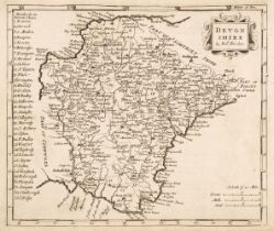
Devon. Bowen (Emanuel), An Accurate Map of Devon Shire Divided into its Hundreds..., circa 1765
Devon. Bowen (Emanuel), An Accurate Map of Devon Shire Divided into its Hundreds, Drawn from the best Authorities, assisted by the most approved M...
Devon. Greenwood (C. & J.), Map of the County of Devon from an Actual Survey, made in the Years 1825 & 1826 by C. & J. Greenwood, most Respectfull...
Devon. Jansson (Jan), Devoniae Descriptio. The Description of Devon-Shire, Amsterdam, circa 1646, engraved map with bright contemporary outline co...
Devon. Speed (John), Devonshire with Excester described and the armes of such nobles as have borne the titles of them, 1st edition, published John...
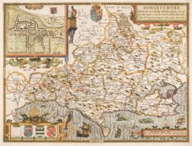
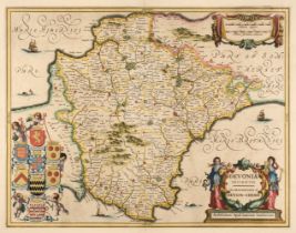
Dorset. Speed (John), Dorsetshyre with the Shyre-towne Dorchester described, as also the Armes of such noble families as have bene honored with th...
East Indies & Asia. Covens (J. & Mortier C.), L'Asie divisée en ses Principales Regions..., Amsterdam, circa 1740, engraved map with contemporary ...
England & Wales. Rocque (John), England and Wales Drawn from the most accurate surveys, Containing all the Cities, Boroughs, Market Towns and Vill...
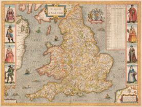
England & Wales. Speed (John), The Kingdome of England, George Humble, 1632, hand-coloured 'carte-a-figure' map engraved by Abraham Goos, eight co...
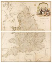
England & Wales. Walker (J & C), England & Wales founded upon the Grand Trigonometrical Survey, Shewing all the Mail Coach, Turnpike & Rail Roads,...
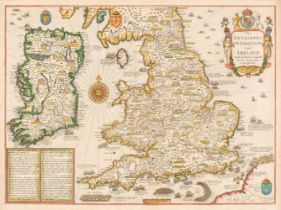
England, Wales & Ireland. Speed (John), The Invasions of England and Ireland with al their Civill Wars since the Conquest, Thomas Bassett & Richar...
Environs of London. A collection of ten maps, 18th and 19th century, engraved and lithographic maps of the environs of London, including examples ...
Environs of London. Faden (William), The Country Twenty-Five Miles Round London planned from a scale of one mile to an Inch, 3rd edition, 1802, en...
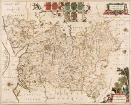
* Essex. Speed (John & Norden John), Essex devided into Hundreds with the most antient and fayre towne Colchester described and other memorable mo...
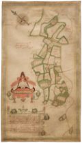
Estate Plan. Boycot (Thomas). A mapp and Description of the mannor of hampton Liinge in the parish of braborne In Kent: with: 31: parcells of arra...
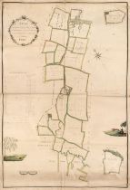
Estate Plan. Sparrow (Joseph), A Map of an Estate belonging to Mr. J. Dunk, also Stock Farm situated in the Parishes of Smeeth, Brabourn & Aldingt...
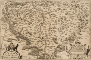
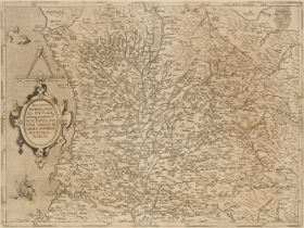
European Countries and Regions. A collection of 73 maps, 16th - 19th century, engraved maps of Europe, Poland, Transylvania, Russia, France, Germa...
Foreign Maps. A collection of approximately 340 maps, mostly 18th & 19th-century, engraved and lithographic country and regional maps together wit...
France & Italy. A collection of 51 maps, 16th - 19th century, engraved regional and country maps and town and city plans, with examples by or afte...
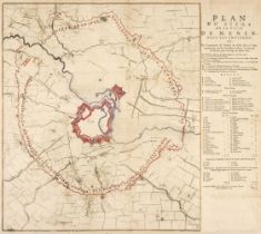
Fricx (Eugene Henri). Plan du Siege de la Ville de Menin avec ses Environs..., Brussels, 1706, engraved battle plan with crude later hand colourin...
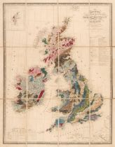
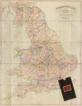
Geological Maps. Wyld (James), Map of the United Kingdom of Great Britain and Ireland, circa 1850, engraved map with contemporary wash colouring, ...
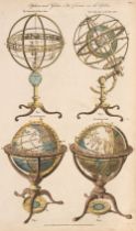
Globes & Speres. A collection of 26 maps and engravings, 18th & 19th century, engravings of globes, armillary spheres, planetariums, telescopes, s...
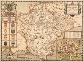
Hampshire & Berkshire. Jansson (Jan), Hantoniae comitatus cum Bercheria, Amsterdam, circa 1648,
* Hampshire & Berkshire. Jansson (Jan), Hantoniae comitatus cum Bercheria, Amsterdam, circa 1648, engraved map with contemporary outline colouring...