
Affinez votre recherche
Filtered by:
- Catégorie
- Liste
- Grille
A subscription to the Price Guide is required to view results for auctions ten days or older. Click here for more information
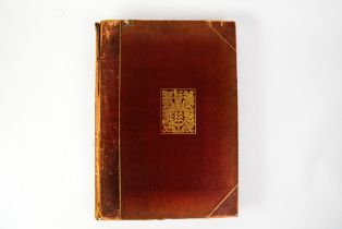

J G Bartholomew - The Survey Atlas of England & Wales, a Series of 84 plates of Maps and Plans, with
J G Bartholomew - The Survey Atlas of England & Wales, a Series of 84 plates of Maps and Plans, with descriptive text, illustrating the Topography...
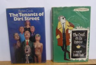
Robin Cook - The Crust on its Uppers, pub New Authors Limited, 1962 1st Edition, dj priced 16s.
Robin Cook - The Crust on its Uppers, pub New Authors Limited, 1962 1st Edition, dj priced 16s. Together with Robin Cook - The Tennant of Dirt Str...
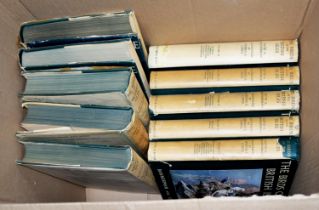
Bannerman - Birds of the British Isles, illustrated by George E Lodge, pub Oliver Boyd, 1953-1961,
Bannerman - Birds of the British Isles, illustrated by George E Lodge, pub Oliver Boyd, 1953-1961, 10 Vol with dustjackets, some light wear, chipp...

James Bain - The Authentic Map Directory of South Lancashire, produced and Published by GEOGRAPHIA
James Bain - The Authentic Map Directory of South Lancashire, produced and Published by GEOGRAPHIA Ltd. Bound in original publisher’s green boards...
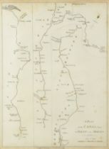
TWO LATE EIGHTEENTH CENTURY PLANS OF CANALS ‘ELLESMERE’ 10 ¼” X 8 ¼” (26cm x 21cm) ‘FROM TRENT TO
TWO LATE EIGHTEENTH CENTURY PLANS OF CANALS ‘ELLESMERE’ 10 ¼” X 8 ¼” (26cm x 21cm) ‘FROM TRENT TO THE MERSEY’ 11”x 8” (28cm x 20.3cm) AND A REP...
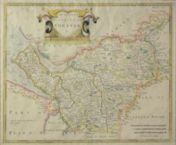
ANTIQUE HAND COLOURED MAP OF CHESTER BY ROBERT MORDEN 13 ½” x 16 ¼” (34.3cm x 41.2cm), foxing
ANTIQUE HAND COLOURED MAP OF CHESTER BY ROBERT MORDEN 13 ½” x 16 ¼” (34.3cm x 41.2cm), foxing
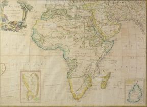
ANTIQUE FRENCH HAND COLOURED MAP OF AFRICA BY DELAMARCHE, 1768, with two vignettes for Du Cape De
ANTIQUE FRENCH HAND COLOURED MAP OF AFRICA BY DELAMARCHE, 1768, with two vignettes for Du Cape De Bone E Sperance and De L’isles De France, 18 ½” ...
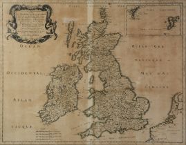
ANTIQUE FRENCH MAP OF BRITAIN, 1665, REPRINTED BY PIERRE MARETTE, 16” X 20 ½” (40.6cm x 52cm)
ANTIQUE FRENCH MAP OF BRITAIN, 1665, REPRINTED BY PIERRE MARETTE, 16” X 20 ½” (40.6cm x 52cm)
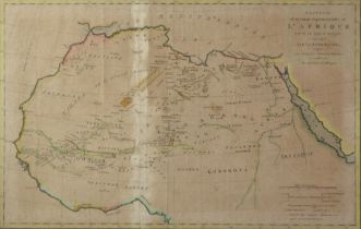
ANTIQUE HAND COLOURED MAP OF NORTHREN AFRICA DRAWN IN 1790 AND CORRECTED IN 1793 BY MAJOR RENNELL,
ANTIQUE HAND COLOURED MAP OF NORTHREN AFRICA DRAWN IN 1790 AND CORRECTED IN 1793 BY MAJOR RENNELL, 13” x 20 ¼” (33cm x 51.4cm)

TWO 1890 BLACK AND WHITE SINGLE SHEET ‘ORDANANCE SURVEY OF SCOTLAND’ MAPS KINGUSSIE- SHEET 64,
TWO 1890 BLACK AND WHITE SINGLE SHEET ‘ORDANANCE SURVEY OF SCOTLAND’ MAPS KINGUSSIE- SHEET 64, tear to right margin GRANTOWN- SHEET 74, published ...