Filtered by:
- Sale Section
- Liste
- Grille
A subscription to the Price Guide is required to view results for auctions ten days or older. Click here for more information
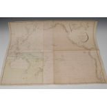

Aaron Arrowsmith (1750-1823), by, a four-fold map, Reduced Chart of the Pacific Ocean from the one published in Nine Sheets, published by A. Arrow...
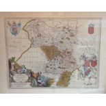
Joan Blaeu (1596-1673), after, a two-page map, Darbiensis Comitatus, Vernacule Darbie Shire [Derbyshire] (sic), later hand-colouring, 50cm x 58cm

Johann Christian Harenberg (1696-1774), by, a two-page map, Palestine seu Terra olim Sancta [La Palestine ou La Terre Sainte], titled in the botto...

Johann Christoph Harenberg (1696-1774), a two-page map, Imperii Turcicie Europaei Terra, in primis Graecia, commissioned by Charles Wilhelm Ferdin...
![Johann Matthias Haas (1684-1742), after, a two-fold map, Carte d' Hongrie [Hungary] (sic),](https://portal-images.azureedge.net/auctions-2015/bamfor10232/images/f3fb15a2-190f-4479-fdd8-4e63c85bcec1.jpg?w=155&h=155)
Johann Matthias Haas (1684-1742), after, a two-fold map, Carte d' Hongrie [Hungary] (sic), for the Homann Heirs, Nürnberg 1744, copperplate engrav...
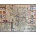
John Speed (1552-1629), by, a two-page map, Darbieshire (sic), 'to be fold in popes head Alley by John Sudbury and G. Humble [London] (sic), coppe...
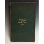
Richardson's Chart of the British Isles, 1916, 1:950,000 scale, two six-fold maps laid on canvas bound in a green buckram folio, the front cover t...
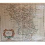
Robert Morden (1650-1703), by, a two-page map, Darbyshire (sic), Sold by Abel Swale, Awnfham and John Churchill (sic), hand-coloured copperplate e...