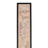

THE OARSMANS AND ANGLERS MAP OF THE THAMES Mounted, framed and glazed 175 x 14cm overall
Collectables
361 item(s)
Filtered by:
- Primary Category,
- Item Type,
- Auction Type
- List
- Grid
-
361 item(s)/page
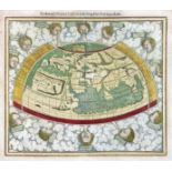
WORLD MAP -- "PTOLEMEISCH GENERAL TAFEL / die halbe Kugel der Welt begreiffende". (Basel, c. 1590). Handcold. woodcut double-page map from S. Muns...
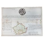
BELARUS -- MANUSCRIPT MAP of the Belarusian city of Polotsk. (1786). Plan of Polotsk drawn on blueish paper by Ivan Abramovich (?), cold. by hand,...

Ortelius (Abraham) Indiae Orientalis Insularumque Adiacientium Typus, hand-coloured map of Southeast Asia, Japan, and the Philippines, etc., ...

London. Reynolds' Large Coloured Map of London and its Suburbs with visitors Guide, Street Directory Views etc. first an engraved folding map wit...
Lot 918
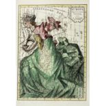
ALLEGORICAL MAP -- (EUROPA REGINA, Queen Europe). (Basel, H. Petri, 1588). Plain allegorical
ALLEGORICAL MAP -- (EUROPA REGINA, Queen Europe). (Basel, H. Petri, 1588). Plain allegorical woodcut map from S. Munster's 'Cosmographey', German ...
Lot 936
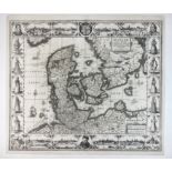
DENMARK -- "DANIAE REGNI TYPUM". (Amst.), J. Janssonius, 1629. Plain engr. map incorporating
DENMARK -- "DANIAE REGNI TYPUM". (Amst.), J. Janssonius, 1629. Plain engr. map incorporating 8 city views (incl. Copenhagen, Helsingør, Lubeck, an...

Lot 940
EASTERN EUROPE -- POLAND -- "ZAMOSCIUM, Nova Poloniæ civitas, (…)". (Cologne, Braun & Hogenberg, 161
EASTERN EUROPE -- POLAND -- "ZAMOSCIUM, Nova Poloniæ civitas, (…)". (Cologne, Braun & Hogenberg, 1617/18). Engr. view of Zamosc. 337 x 495 mm. (Ma...

One packet: Mixed architectural plan and maps of Norfolk interest, to include: Hethersett, Wroxham, Carbrooke, Trunch etc

Lot 412
John Speed (British,1552-1629) Cumberland, handcoloured engraved map, circa 1627, 42x53cm, framed
412John Speed (British,1552-1629) Cumberland, handcoloured engraved map, circa 1627, 42x53cm, framed
John Speed (British,1552-1629) Cumberland, handcoloured engraved map, circa 1627, 42x53cm, framed and glazed.

Lot 339
DEVON. Speed, John.
DEVON. Speed, John. Devonshire with Excester Described, an engraved county map, hand coloured, to be sold by Bassett & Chiswell (1676 edn.), in a ...

London. Fraser's Panoramic Plan of London, London, 1831, James Fraser, a steel engraved folding map dissected in fifteen sections and backed on ...

London. Bowles's Reduced New Pocket Plan of the Cities of London and Westminster, with the Borough of Southwark, exhibiting the New Buildings to 1...
ALLEGORICAL MAP -- "EUROPA Volgens de nieuwste Verdeeling". Haarlem, F. Bohn, (1794). Cont. handcold. allegorical engr. map. 237 x 167 mm. (Left b...
![[DEVON] BLAEU, Joan.](https://portal-images.azureedge.net/auctions-2024/bearne10150/images/9bf08fd8-a4c6-4b36-a926-b15000fc8d1a.jpg?w=155&h=155)
Lot 330
[DEVON] BLAEU, Joan.
[DEVON] BLAEU, Joan. Devonia vulgo Devon-Shire, hand coloured map, 1645 or later, latin text, f&g, 40cm x 52cm; together with MORDEN, Robert. Devo...
![[ATLAS] COLE and ROPER. Nightingale, Joseph.](https://portal-images.azureedge.net/auctions-2024/bearne10150/images/4bd431a9-b8cb-49bb-9b6a-b15000fc8b3f.jpg?w=155&h=155)
[ATLAS] COLE and ROPER. Nightingale, Joseph. English Topography: or, a series of … Counties of England and Wales. Accompanied by a Map of each Cou...
Lot 363A
SPEED, John.
SPEED, John. Kent, with her Cities and Earles described and observed, hand coloured map with inset plans of Rochester and Canterbury, English text...
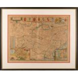
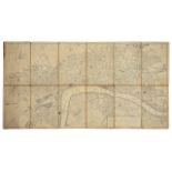
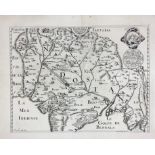
Thames. Ravenstein's Oarsmen's and Anglers Map of the River Thames from its source to London Bridge a concertina style folding map backed on line...

London. Mogg's Stranger's Guide Through London and entirely New Plan. .....' steel engraved dissected folding map with hand colouring in twelve s...

London. Wyld's New Map of London, 1877 London, James Wyld, 1876, an engraved dissected map in forty sections backed on linen with some colouring,...

London. Tallis's Illustrated Plan of London and Its Environs, in commemoration of the Great Exhibition of Industry of All Nations 1851 a steel en...

Lot 41
A good collection of Wade buildings to include Whimsey on Why, with paper maps / village layouts,
A good collection of Wade buildings to include Whimsey on Why, with paper maps / village layouts, new-old stock condition (Qty). Condition genera...
![[ATLAS] BELL, WilIam.](https://portal-images.azureedge.net/auctions-2024/bearne10150/images/5f19849a-3249-4645-8396-b15000fc8ac4.jpg?w=155&h=155)
Lot 325
[ATLAS] BELL, WilIam.
[ATLAS] BELL, WilIam. A New General Atlas … principal countries in ...
Lot 250
MOUNTAINEERING.
MOUNTAINEERING. Whymper, Edward, Scrambles Amongst the Alps in the Years 1860-69, London: John Murray 1893, 4th edition, folding maps and plates, ...

Lot 363
SPEED, John.
SPEED, John. Devonshire with Excester Described, published by John Sudbury & George Humble 1623, hand coloured map, Exeter shown in an inset to on...

London. Lewis, (Samuel) A plan of London and its Environs shewing the Boundaries, shewing the Boundaries of the Cities of London and Westminster, ...
London. A New and Correct Plan of London, Westminster and Southwark, with several additional Improvements, not in any former Survey an engraved d...

London. Cruchley's New Plan of London improved to 1830 an engraved dissected map in thirty six sections, backed on linen and with hand colouring,...

Lot 359
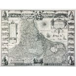
John Speed (1552-1629) Engraving Worcestershire Described, John Sudbury & George Humble (1627),
John Speed (1552-1629) Engraving Worcestershire Described, John Sudbury & George Humble (1627), hand-coloured engraved map, an inset town plan ...
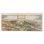
Lot 934
CITY VIEWS / PLANS -- "PRAGA, BOHEMIAE METROPOLIS accuratissime expressa". (Cologne, Braun & Hogenbe
CITY VIEWS / PLANS -- "PRAGA, BOHEMIAE METROPOLIS accuratissime expressa". (Cologne, Braun & Hogenberg, c. 1618). Handcold. engr. view of Prague (...
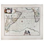
SPAIN -- "HISPANIÆ, et Portugalliæ Maritimi tractus, à S. Andreo, ad Malagam/Pascaert van Spangie, en Portugal". (Amst., L. Renard, 1715). Handcol...

CASPIAN SEA -- "NIEUWE CAART van de Caspische Zee, met alle desselfs riviere, eylanden en dieptens; na de laatste observatien gelegt en verbeeterd...
ASIA -- INDIA -- "L'INDOSTAN: description de la partie des Indes Orientales qui est sous la domination du grand Mogol". (1660-1679). Plain engr. m...
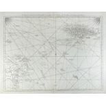
SEA CHARTS -- "MAR DI AETHIOPIA Vulgo Oceanus Aethiopicus". Amst., J. Janssonius, (c. 1680). Handcold. engr. chart. 437 x 557 mm. (Sl. browned, a ...
Lot 921
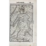
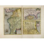
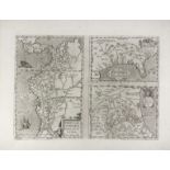
AMERICA -- "PERUVIAE AURIFERAE Regionis Typus". - On sheet with: "LA FLORIDA". - And: "GUASTECAN
AMERICA -- "PERUVIAE AURIFERAE Regionis Typus". - On sheet with: "LA FLORIDA". - And: "GUASTECAN Reg." - (Antw., A. Ortelius, C. 1588). Handcold. ...

Lot 75
A late 19thC Ordnance Survey map for Highnorth Being Centre 20 Miles Round, Moreton in the Marsh and
A late 19thC Ordnance Survey map for Highnorth Being Centre 20 Miles Round, Moreton in the Marsh and Chipping Norton, dated 1897, Retailed by Edwa...

Lot 415
WILLEM JANSSON BLAEU (1571 - 1638): 17th century (c1635) engraved coloured map of Lake Geneva
WILLEM JANSSON BLAEU (1571 - 1638): 17th century (c1635) engraved coloured map of Lake Geneva after J Coulart from an early edition of Blaeu's ATL...

An assortment of various etched maps, to include Daniel Paterson Direct Roads, c1785, Thomas Badeslade Map of Hampshire, c1741, Van Den Keere - So...
![[BIBLE, Dutch. Biblia neerlandica]. Biblia, dat is De gantsche H.](https://portal-images.azureedge.net/auctions-2024/bearne10150/images/b9913667-9d4f-4fdb-aa34-b15000fb28d3.jpg?w=155&h=155)
[BIBLE, Dutch. Biblia neerlandica]. Biblia, dat is De gantsche H. Schrifture, vervattende alle de Canonijcke Boecken des Ouden en des Nieuwen Test...
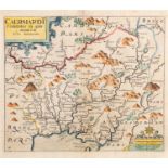
SAXTON, Christopher and William Kip. Caermardi Comitatus in quo Dimetae olim habitarunt (Carmarthenshire), 17th century engraved map with hand-col...

Lot 338
DEVON. GREENWOOD, C. & J.
DEVON. GREENWOOD, C. & J. Map of the County of Devon from an actual Survey made in the Years 1825 and 1826..., July 4th 1829, hand coloured engrav...

Lot 357
SAXTON, Christopher (Kip).
SAXTON, Christopher (Kip). Radnor Comitatue Quem Silvres, hand coloured engraved map, 1579-1600, 27cm x 32cm

Lot 353
MORDEN, Robert.
MORDEN, Robert. Devonshire, hand coloured engraved map, 1685 or later, browned, 36cm x 41cm

Lot 67
Uk maps: Speed (John)
UK maps Speed (John) Hartfordshire Described, first edition, hand-coloured engraving, after Jodocus Hondius, from The Theatre of Empire of Gr...

British maps: Herman Moll, The North Part of Great Britain called Scotland, flanked by a chart of the Orkneys & Shetlands and eleven vi...

Wallis’s Complete Voyage Round the World, a new Geographical Pastime, engraved map of the world hand coloured, with instructions how...

London. Mogg (Edward) An Entire New Plan of the Cities of London & Westminster with the Borough of Southwark, Comprehending the New Buildings and ...

After Michael Drayton (British, 1563-1631) - An etching on paper and hand coloured map of Glocestershyre (sic - Gloucestershire), from the poetic ...

Lot 361
Johannes Blaeu (1599-1673), Bercheria vernacule Barkshire, hand-coloured engraved map, circa 1645,
Johannes Blaeu (1599-1673) , Bercheria vernacule Barkshire, hand-coloured engraved map, circa 1645, framed and glazed, 49cm x 56.5cm
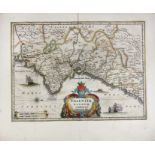
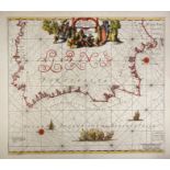
SPAIN -- "VALENTIA REGNUM (…)". (Amst., c. 1650). Partly handcold. engr. map w. compass rose, sea monster, ships in full sea and cartouche. 355 x ...
SOUTH AMERICA -- CARIBBEAN -- "THE ISLAND OF JAMAICA and Cape Gracias a Dios with the Banks". Lond., printed for R. Sayer, 1775. Plain engr. chart...
ASIA -- CHINA -- "ASIAE VIII TAB:". (c. 1600). Handcold. engr. map of Central Asia (& Western China). 344 x 405 mm. (A few sm. marg. tears, a bit ...
LOW COUNTRIES -- "BELGIUM, Sive Inferior Germania post omnes in hac forma, exactissimè descripta auct. Abrahamo Goos". Amst., J. Janssonius, 1631....
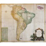
SOUTH AMERICA -- "A MAP OF SOUTH AMERICA containing Tierra Firma, Guyana, New Granada, Amazonia, Brasil, Peru, Paraguay, Chaco, Tucuman, Chili and...
Lot 922
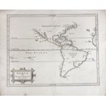
AMERICA -- "PERUVIAE AURIFERAE Regionis Typus". - On sheet with: "LA FLORIDA". - And: "GUASTECAN
AMERICA -- "PERUVIAE AURIFERAE Regionis Typus". - On sheet with: "LA FLORIDA". - And: "GUASTECAN Reg." - (Antw., A. Ortelius, C. 1588). Plain engr...
Lot 920
AMERICA -- "AMERICAE sive Indiae Occidentalis tabula generalis". (Leyden, c. 1630). Plain engr
AMERICA -- "AMERICAE sive Indiae Occidentalis tabula generalis". (Leyden, c. 1630). Plain engr. map of North and South America by J. de Laet/H. Ge...
ASIA -- CHINA -- "KANTON IN PLATTE GRONDT / Plate forme de la Ville de Kanton". (Amst., c. 1665). Plain engr. map from J. Nieuhoff. 286 x 365 mm. ...
SPAIN -- "VALENTIA REGNUM (…)". Amst., G. Blaeu, (1635). Handcold. engr. map w. compass rose, sea monster, ships in full sea and cartouche. 385 x ...

Lot 397
A pair of maps: GERMANY, folio size, woodcut: 16th century, Sebastian Munster, Cosmographia, View of
A pair of maps: GERMANY, folio size, woodcut: 16th century, Sebastian Munster, Cosmographia, View of Worms of Germany, German black letter to rect...

ONE BOX: Various 19th and 20th century folding maps