

Title: Bacons Vintage London Metropolitan Police Courts Coloured Map. Description: Bacons Vintage London Metropolitan Police Courts Co...
Collectables
233 item(s)
Filtered by:
- Primary Category,
- Category,
- Auction Type
- List
- Grid
-
233 item(s)/page

Title: Collection 9 Rare Vintage George Bacon London & Suburbs Large Scale Maps Description: Collection 9 Rare Vintage George Bacon Lo...

A Coloured City Map Of Exeter Circa 1597
Lot 7
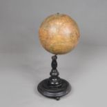
Table Globe
Table Globe, paper printed and described in German on original ebonized stand around 1900. 40 cm high.

Mary STORK (1938-2007) Female in Repose Pastel on paper Information to the verso states it was previously sold in the estate sale of Rose Hil...

A 17th Century Framed Double Sided Map Of Cardiganshire

Early Map Of London And The Surrounding Area

A Framed Hand Coloured Map Of Glamorganshire

A carton of assorted Ordnance Survey Maps mainly UK.

Lot 38
*Local Interest - After Robert Morden (1650-1703, British), coloured engravings, Two illustrations
38*Local Interest - After Robert Morden (1650-1703, British), coloured engravings, Two illustrations
*Local Interest - After Robert Morden (1650-1703, British), coloured engravings, Two illustrations of local interest - Maps of 'Cumberland' & 'Wes...

17th Century Hand Coloured Map Of Denbigh

Lot 73
A Collection Of Three Maps Including A Western And Eastern Hemispere And Africa Septentrionalis
A Collection Of Three Maps Including A Western And Eastern Hemispere And Africa Septentrionalis

Turkey III Containing The Sothern Part Of Greece And Candia. Date 1829

A 17th Century Map Of Herefordshire

A Hand Coloured Map Of Warwickshire (1650 - 1703)

The Small Islands In The British Ocean By Rodert Morden (1650-1703)

Fold Out Map Of Warwickshire Dated 1830


Lot 100
Walter Cox (American,1866-1930), The Celebration of the Fourth of June at Eton, hand coloured
Walter Cox (American,1866-1930), The Celebration of the Fourth of June at Eton, hand coloured engraved map, signed in pencil by Cox and A.H. Wardl...


4 Country Maps Including Herefordshire And A Map Of England And Wales

Robert Morden (1650 - 1703) Coloured Map Of Stafford Shire

Two Huntingshire Maps And One Worcestershire

Two Coloured Engraved Maps. Dorsetshire and Cornwall

A Collection Of Six Maps Including A Cardigan Road Map


Worcestershire And Herefordshire Map

Map Of Monmouthshire And Huntingdonshire

Map Of Warwickshire Dated 1834

A Framed Hand Coloured Map Of Herefordshire

Map Of Monmouthshire Divided Into Hundreds

A Road Map From St Davids to Holywell

A Dorset Map By Robert Morden (1650-1703)

A Hand Coloured Map Of Leicestershire By Robert Morden (1650-1703)

A Hand Coloured Map Of North Wales

A 19th Century Map Of Wales And England

A 19th Century Hand Coloured Map Of Gurnsey


A small selection of vintage Ordnance Survey maps and similar covering Britain and Europe.

DEVONSHIRE. Leaf from Britannia Depicta or Ogilby Improv'd, with strip map of route NW from Exeter via Crediton, and overleaf Barnstaple, Ilfracom...

Ray-Ban Unisex Sunglasses Black Round Double Bridge Black Frame- appear unworn examples with as pictured all relevant original paperwork and packa...

Circuit Maps signed by Michele Alboreto and Nelson Piquet, one circuit Kyalami, annotated in blue pen and signed by Nelson Piquet in blue pen,30 x...
Lot 171
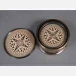
Kelvin & Hughes Compass
Kelvin & Hughes Compass, in metal box. Movable. 20th Century. 8 cm diameter.
Lot 9
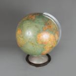
Columbus Globe
Columbus Globe, paper with colour printed card, on metal base. Berlin around 1960.

Title: North & East Riding Yorkshire 1895 Antique Victorian Coloured Map. Description: North & East Riding Yorkshire 1895 Antique Vict...

Title: The Isle of Man 1895 Antique Victorian Coloured Map. Description: The Isle of Man 1895 Antique Victorian Coloured Map. This ...

Title: Lancashire North 1895 Antique Victorian Detailed Coloured Map. Description: Lancashire North 1895 Antique Victorian Coloured Ma...

Title: Environs Liverpool & Manchester 1895 Antique Victorian Coloured Map. Description: Environs Liverpool & Manchester 1895 Antiqu...

Title: Lake District & Cumbria 1895 Antique Victorian Coloured Map. Description: Lake District & Cumbria 1895 Antique Victorian Colour...

Title: County Cheshire 1895 Antique Victorian Detailed Coloured Map. Description: County Cheshire 1895 Antique Victorian Coloured Map....

Title: County Northumberland 1895 Antique Victorian Coloured Map. Description: County Northumberland 1895 Antique Victorian Coloure...

Title: County Durham 1895 Antique Victorian Detailed Coloured Map. Description: County Durham 1895 Antique Victorian Coloured Map. ...

Title: Counties of North Wales 1895 Antique Victorian Coloured Map. Description: Counties of North Wales 1895 Antique Victorian Colour...

Title: Counties of South Wales 1895 Antique Victorian Coloured Map. Description: Counties of South Wales 1895 Antique Victorian Colour...

Title: County Cambridgeshire 1895 Antique Victorian Coloured Map. Description: County Cambridgeshire 1895 Antique Victorian Coloured M...

Title: County Kent 1895 Antique Victorian Coloured Map. Description: County Kent 1895 Antique Victorian Coloured Map. This Coloured...

Title: The Channel Islands 1895 Antique Victorian Coloured Map. Description: The Channel Islands 1895 Antique Victorian Coloured Map. ...

Title: County Leicestershire 1895 Antique Victorian Coloured Map. Description: County Leicestershire 1895 Antique Victorian Coloured M...

Title: County Lincolnshire 1895 Antique Victorian Coloured Map. Description: County Lincolnshire 1895 Antique Victorian Coloured Map. ...

Title: County Middlesex & London 1895 Antique Victorian Coloured Map. Description: County Middlesex 1895 Antique Victorian Coloured M...