Refine your search
Filtered by:
- Sale Section,
- Category
- List
- Grid
This auctioneer has chosen to not publish their results. Please contact them directly for any inquiries.
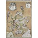

Hubert Jaillot (publisher) - 'Le Royaume d'Escosse' (Map of Scotland), 17th century engraving with
Hubert Jaillot (publisher) - 'Le Royaume d'Escosse' (Map of Scotland), 17th century engraving with hand-colouring on laid paper, 90.5cm x 60.5cm, ...
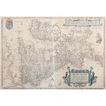
Franz Hogenberg - 'Angliae, Scotiae, Et Hiberniae' (Map of the British Isles), late 16th/early
Franz Hogenberg - 'Angliae, Scotiae, Et Hiberniae' (Map of the British Isles), late 16th/early 17th century engraving with later hand-colouring on...
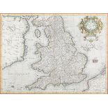
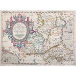
Gerard Mercator - 'Anglia Regnum' (Map of England and Wales), 17th century engraving with later
Gerard Mercator - 'Anglia Regnum' (Map of England and Wales), 17th century engraving with later hand-colouring on laid paper, 35cm x 47cm, within ...
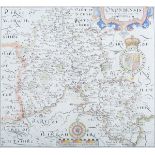
William Hole, after Christopher Saxton - 'Oxoniensis Comitatu' (Map of Oxfordshire), 17th century
William Hole, after Christopher Saxton - 'Oxoniensis Comitatu' (Map of Oxfordshire), 17th century engraving with later hand-colouring on laid pape...
Mario Cartaro, after Egnatio Dante - 'Perusini' (Map of Perugia), late 16th/early 17th century
Mario Cartaro, after Egnatio Dante - 'Perusini' (Map of Perugia), late 16th/early 17th century engraving with later hand-colouring on laid paper, ...
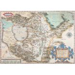
Franz Hogenberg, after Giacomo Gastaldi - 'Romaniae' (Map of the Eastern Balkans), late 16th/early
Franz Hogenberg, after Giacomo Gastaldi - 'Romaniae' (Map of the Eastern Balkans), late 16th/early 17th century engraving with later hand-colourin...

Edward Stanford (publisher) - Ordnance Survey of England and Wales, a part set of eighty 19th
Edward Stanford (publisher) - Ordnance Survey of England and Wales, a part set of eighty 19th century engravings, the majority hand-coloured, fold...

Ordnance Survey (publishers) - 'River Medway, Bishops Ness to Rochester, Sheets 1 & 2' (Hydrographic
Ordnance Survey (publishers) - 'River Medway, Bishops Ness to Rochester, Sheets 1 & 2' (Hydrographic Charts), early 20th century lithographs backe...