Filtered by:
- Sale Section
- List
- Grid
A subscription to the Price Guide is required to view results for auctions ten days or older. Click here for more information

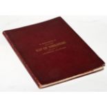
REPORT OF THE BOUNDARY COMMISSIONERS 1888, London, Local Government Boundries Commission, 2 folio
REPORT OF THE BOUNDARY COMMISSIONERS 1888, London, Local Government Boundries Commission, 2 folio volumes, numerous maps (some folding) arranged a...
Nightingale (Joseph) English Topography: or a series of Historical and Statistical Descriptions of
Nightingale (Joseph) English Topography: or a series of Historical and Statistical Descriptions of the Several Counties of England and Wales, 1816...
Letts, Son & Co. (Publishers) Letts's Popular County Atlas being a Complete Series of Maps Delineating the whole Surface of England and Wales...18...
Teesdale (Henry, Publisher) A New General Atlas of the World... from Drawings made Expressly for
Teesdale (Henry, Publisher) A New General Atlas of the World... from Drawings made Expressly for this Work, by John Dower, 1840, London, H. Teesda...
![Baker (Robert, Surveyor) [Map of Antigua] Antigue, Levee par Robert Baker, Arpenteur General de l'](https://portal-images.azureedge.net/auctions-2017/srten10391/images/c4212b1a-673e-4e11-ff3e-3b2082ffd41c.jpg?w=155&h=155)
Baker (Robert, Surveyor) [Map of Antigua] Antigue, Levee par Robert Baker, Arpenteur General de l'
Baker (Robert, Surveyor) [Map of Antigua] Antigue, Levee par Robert Baker, Arpenteur General de l'Isle. 1779, Paris, hand-coloured engraved double...
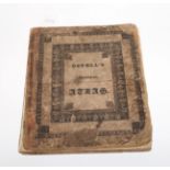
WORLD ATLAS Ostell's New General Atlas; containing Distinct Maps of all the Principal States and
WORLD ATLAS Ostell's New General Atlas; containing Distinct Maps of all the Principal States and Kingdoms throughout the World...A New Edition, 18...
![Saxton (Christopher) and Hole (William) [Map of Cheshire] Cestriae Comitatus Romanis Legionibus et](https://portal-images.azureedge.net/auctions-2017/srten10391/images/471c5d6c-bb70-4a03-b92b-f3d7a9e49132.jpg?w=155&h=155)
Saxton (Christopher) and Hole (William) [Map of Cheshire] Cestriae Comitatus Romanis Legionibus et
Saxton (Christopher) and Hole (William) [Map of Cheshire] Cestriae Comitatus Romanis Legionibus et Coloniis olim insignis vera et absoluta descri...
![Tombleson (William) Tombleson's Panoramic Map of the Thames and Medway, [London, c.1846], hand-](https://portal-images.azureedge.net/auctions-2017/srten10391/images/56f90991-89f3-460e-f08e-ec36a92b6671.jpg?w=155&h=155)
Tombleson (William) Tombleson's Panoramic Map of the Thames and Medway, [London, c.1846], hand-
Tombleson (William) Tombleson's Panoramic Map of the Thames and Medway, [London, c.1846], hand-coloured steel engraving on two joined sheets of fi...
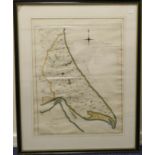
Tuke (John) Map of Holderness, 1786, engraved map with outline colour by hand, compass rose and
Tuke (John) Map of Holderness, 1786, engraved map with outline colour by hand, compass rose and table of 'Distances from several Villages to the S...

Goad (Charles E.) Insurance Plans of Goole Yorkshire, March 1896 (-1911), London, Goad, two complete
Goad (Charles E.) Insurance Plans of Goole Yorkshire, March 1896 (-1911), London, Goad, two complete sets of three lithographed plans, comprising ...
![Stanford (Edward, Publishers) Ordnance Survey [Map] of Yorkshire, 1865, London, E. Stanford,](https://portal-images.azureedge.net/auctions-2017/srten10391/images/e1a5778d-abf3-4fd2-ab5d-6a13f687d7ce.jpg?w=155&h=155)
Stanford (Edward, Publishers) Ordnance Survey [Map] of Yorkshire, 1865, London, E. Stanford, complete in seven parts with outline colour by hand,...
![Speed (John) Cornwall, 1610 [but c.1614?], John Sudbury and George Humble, engraved map by](https://portal-images.azureedge.net/auctions-2017/srten10391/images/55d0d5d8-e538-47df-9a7c-1d4fe0b8bcf2.jpg?w=155&h=155)
Speed (John) Cornwall, 1610 [but c.1614?], John Sudbury and George Humble, engraved map by Hondius (signature in plate), attractive early colour b...
![Ortelius (Abraham) and Lhuyd [Llwyd] (Humphrey) [Map of England and Wales] Angliae Regni](https://portal-images.azureedge.net/auctions-2017/srten10391/images/935d5399-75dc-491d-96b0-9aa529acc2f2.jpg?w=155&h=155)
Ortelius (Abraham) and Lhuyd [Llwyd] (Humphrey) [Map of England and Wales] Angliae Regni Florentissimi Nova Descriptio, Auctore Humfredo Lhuyd Den...
![GEOLOGICAL MAPS No.XLIV [44, Worcestershire/Gloucestershire]; No.LV [55, Herefordshire/](https://portal-images.azureedge.net/auctions-2017/srten10391/images/df7a2353-7203-450e-f2ee-9748eedc2c80.jpg?w=155&h=155)
GEOLOGICAL MAPS No.XLIV [44, Worcestershire/Gloucestershire]; No.LV [55, Herefordshire/Worcestershire]; No.LXXIV [74, Llangollen/North Wales]; No....
Bacon, G.W. & Co. (Publishers) Bacon's Excelsior Map of Yorkshire and parts of Adjoining Counties,
Bacon, G.W. & Co. (Publishers) Bacon's Excelsior Map of Yorkshire and parts of Adjoining Counties, 1901 colour printed map with inset geological ...
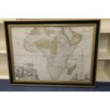
Senex (John) Africa Corrected from the Observations of the Royal Society of London and Paris, [c.
Senex (John) Africa Corrected from the Observations of the Royal Society of London and Paris, [c.1720, London], large engraved map on two sheets j...
IMPORTANT MAP OF DERBYSHIRE Burdett (P.P.) To The Right Honourable The President, Vice-Presdient…
IMPORTANT MAP OF DERBYSHIRE Burdett (P.P.) To The Right Honourable The President, Vice-Presdient…of the Society for the Encouragement of Arts, &c...