Filtered by:
- Sale Section
- List
- Grid
A subscription to the Price Guide is required to view results for auctions ten days or older. Click here for more information
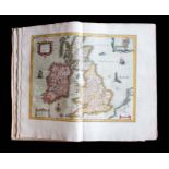

Atlas. England & Wales. Blaeu, Willem and Joan Blaeu. Le Theatre du Monde, Quatriesme Partie [
Atlas. England & Wales. Blaeu, Willem and Joan Blaeu. Le Theatre du Monde, Quatriesme Partie [Theatrum, Vol. IV: England & Wales], the first Frenc...
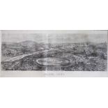
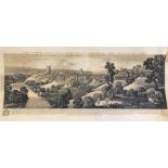
Panorama of Paris. An uncoloured wood engraving, published as a supplement to the Illustrated London
Panorama of Paris. An uncoloured wood engraving, published as a supplement to the Illustrated London News, 6 July 1867, linen-backed & rolled, 55c...
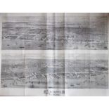
Double panorama of Liverpool. An uncoloured wood engraving, published as a supplement to the Illustrated London News, 29 April 1865, backed with J...
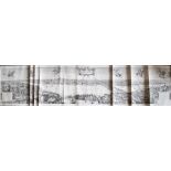
London. Hollar, Wenceslaus & Danckerts, Cornelis (after). "The Long View", A large panorama of
London. Hollar, Wenceslaus & Danckerts, Cornelis (after). "The Long View", A large panorama of London in 1647, lithograph by Robert Martin, 1832, ...
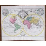
World. Delisle, Guillaume (after). Mappa Totius Mundi. A double hemisphere world map published by
World. Delisle, Guillaume (after). Mappa Totius Mundi. A double hemisphere world map published by Tobias Conrad Lotter, [c. 1760-70]. Hand-coloure...
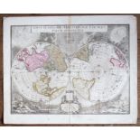
World. Blaeu, Joan & Valck, Gerard. Novus Planiglobii Terrestris Per Utrumque Polum Conspectus. A
World. Blaeu, Joan & Valck, Gerard. Novus Planiglobii Terrestris Per Utrumque Polum Conspectus. A double hemisphere map of the world on a polar pr...
![Southeast Asia. Jansson, Jan. Indiae Orientalis Nova Descriptio [c.1630-50]. An uncoloured copper-](https://portal-images.azureedge.net/auctions-2023/hanson10540/images/8dd99ffc-6cc8-40ec-970b-affe0093052c.jpg?w=155&h=155)
Southeast Asia. Jansson, Jan. Indiae Orientalis Nova Descriptio [c.1630-50]. An uncoloured copper-
Southeast Asia. Jansson, Jan. Indiae Orientalis Nova Descriptio [c.1630-50]. An uncoloured copper-engraved map on creamy laid/chain-lined paper wi...
![Southeast Asia. Valck & Schenk. India quae Orientalis dicitur et Insulae Adiacentes [c. 1695]. A](https://portal-images.azureedge.net/auctions-2023/hanson10540/images/52acbcc9-8d0a-42bb-a826-affe00932bc5.jpg?w=155&h=155)
Southeast Asia. Valck & Schenk. India quae Orientalis dicitur et Insulae Adiacentes [c. 1695]. A
Southeast Asia. Valck & Schenk. India quae Orientalis dicitur et Insulae Adiacentes [c. 1695]. A scarce edition of Hondius's map, which was based ...
Coronelli, Vincenzo Maria. A set of four gores of the Southern Hemisphere including Australia.
Coronelli, Vincenzo Maria. A set of four gores of the Southern Hemisphere including Australia. Hand-coloured copper engravings on creamy laid/chai...
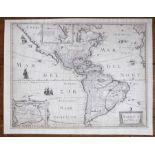
America. Mariette, Pierre. America Noviter Delineata. A scarce map of America derived from Hondius, uncoloured copper engraving on laid/chain-line...
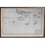
Discovery of Tasmania & New Zealand. Valentyn, Francois. A scarce map of Australia, New Zealand
Discovery of Tasmania & New Zealand. Valentyn, Francois. A scarce map of Australia, New Zealand and part of Southeast Asia, showing the track of A...
Sea Charts. A General Chart of the Indian and part of the Pacific Oceans, Shewing the various
Sea Charts. A General Chart of the Indian and part of the Pacific Oceans, Shewing the various Passages to & from China, Australia, New Zealand, Lo...
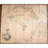
Africa. Arrowsmith, Aaron. A large and historically important map of Africa, 1 November 1802,
Africa. Arrowsmith, Aaron. A large and historically important map of Africa, 1 November 1802, copper-engraving, dissected into 24 sections, linen-...
![Cary, John. [New Map of England and Wales with Part of Scotland, 1794], large scale map, copper-](https://portal-images.azureedge.net/auctions-2023/hanson10540/images/1457c057-088d-4b60-be51-aff90137cef6.jpg?w=155&h=155)
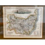
Cary, John. [New Map of England and Wales with Part of Scotland, 1794], large scale map, copper-
Cary, John. [New Map of England and Wales with Part of Scotland, 1794], large scale map, copper-engraved with outline colour by hand, map sections...
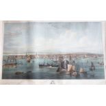
New York. A large and impressive view of Manhattan from the East River, aquatint with engraving, New
New York. A large and impressive view of Manhattan from the East River, aquatint with engraving, New York: F. & G. W. Smith, 1855. The third state...
![Blaeu, J. Map of The Middle Part of Galloway, [c. 1654], uncoloured copper-engraving on laid/chain-](https://portal-images.azureedge.net/auctions-2023/hanson10540/images/36f874a7-922f-46ee-97c7-aff90137d4f4.jpg?w=155&h=155)
Blaeu, J. Map of The Middle Part of Galloway, [c. 1654], uncoloured copper-engraving on laid/chain-
Blaeu, J. Map of The Middle Part of Galloway, [c. 1654], uncoloured copper-engraving on laid/chain-lined paper, 49cm by 63cm, framed & glazed ......
![Kip, William. Hertfordiae [Hertfordshire], copper-engraved map with later hand-colouring on laid/](https://portal-images.azureedge.net/auctions-2023/hanson10540/images/bfb1580b-a8af-4f7a-8389-affd0111bb89.jpg?w=155&h=155)
Kip, William. Hertfordiae [Hertfordshire], copper-engraved map with later hand-colouring on laid/
Kip, William. Hertfordiae [Hertfordshire], copper-engraved map with later hand-colouring on laid/chain-lined paper, 31cm by 38.5cm, framed & glaze...
A small collection of maps comprising: New Map of Cairo, engraved by A. Nicohosoff, Alexandria: Arts
A small collection of maps comprising: New Map of Cairo, engraved by A. Nicohosoff, Alexandria: Arts Graphiques, 1932, publisher's card covers; Cu...
A collection of antique prints comprising: The North East Prospect of Richmond in the County of
A collection of antique prints comprising: The North East Prospect of Richmond in the County of York, etching by Samuel & Nathaniel Buck, dated 17...
![Ortelius, Abraham. Map of Ireland, oriented to the west, [1584]. Eryn. Hiberniae, Britannicae](https://portal-images.azureedge.net/auctions-2023/hanson10540/images/64747221-580a-4998-b670-affd01120efe.jpg?w=155&h=155)
Ortelius, Abraham. Map of Ireland, oriented to the west, [1584]. Eryn. Hiberniae, Britannicae
Ortelius, Abraham. Map of Ireland, oriented to the west, [1584]. Eryn. Hiberniae, Britannicae Insulae, Nova Descriptio. Irlandt. A hand-coloured, ...
![Moll, Herman. Atlas Minor, London: Thomas & John Bowles, [1736 or later]. Quarto, 58 [of 62] hand-](https://portal-images.azureedge.net/auctions-2023/hanson10540/images/f29f5ea7-811f-48e8-8611-affe0094e707.jpg?w=155&h=155)
Moll, Herman. Atlas Minor, London: Thomas & John Bowles, [1736 or later]. Quarto, 58 [of 62] hand-
Moll, Herman. Atlas Minor, London: Thomas & John Bowles, [1736 or later]. Quarto, 58 [of 62] hand-coloured, copper-engraved maps on laid/chain-lin...