Filtered by:
- Sale Section
- List
- Grid
A subscription to the Price Guide is required to view results for auctions ten days or older. Click here for more information
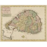

Ceylon. Tirion Isaac), Nieuwe Kaart van 't Eiland Ceilon, Amsterdam, circa 1740, engraved map with contemporary hand colouring, 290 x 370 mmQty: (...
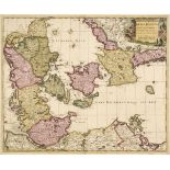
Denmark. Schenk (Petrus), Dania Regnum Ducatus Holsatia. et Slesvicum Insulae Danicae et Provinciae Jutia Scania etc. Amsterdam, 1706, engraved re...
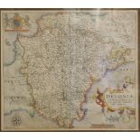
* Devon. Saxton (Christopher & Kip William), Devoniae comitatus vulgo Denshyre..., [1610], hand-coloured engraved map, ornate strapwork cartouche ...
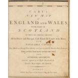
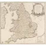
England & Wales. Cary (John), Cary's New Map of England and Wales with Part of Scotland, on which are carefully laid down all the Direct and Princ...
England & Wales. De Vaugondy (Robert), Le Royaume D'Angleterre divisé selon les sept Royaumes ou Heptarchie de Saxons avec la Principauté de Galle...
* France. Mercator (Gerard), Artesia Comit: circa 1607, engraved map with contemporary hand-colouring, 350 x 450 mm, framed and glazedNOTESOrigina...

* Hampshire. Porcelain plate, possibly Coalport, circa 1880, colour transfer design featuring a map of the county of Hampshire, on a white backgro...

* Leicestershire. Speed (John), Leicester both Countye and Citie described, The Honorable Famylies that have had the titles of Earls thereof. With...

London. Cruchley (George Frederick). Ordnance Map of the Country round London, circa 1875, lithographic folding map with contemporary outline colo...

Map Reference. A collection of 37 reference books, 20th century, map reference books, including examples by Moreland & Bannister (9 copies), Roder...
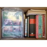
Map Reference. A collection of approximately 130 books and periodicals, 20th century, reference books and periodicals including Mercator's World a...
Map Reference. The British Museum. Catalogue of Printed Maps Charts and Plans, Photolithographic edition, complete to 1964, 16 vols. (including th...

* Merionethshire. Speed (John), Merionethshire Described, George Humble [1627], hand-coloured engraved map, an inset town plan of Harlech, central...

National Geographic Magazine (publishers). Northern and Southern Hemispheres, Washington D. C. 1943, colour lithographic map with airline distance...

Northumberland. Blaeu (Johannes), Comitatus Northumbria vernacule Northumberland, Amsterdam circa 1648, engraved map with contemporary outline col...

Nottinghamshire. Greenwood (C. & J.), A Map of the County of Nottingham from an actual survey made in the years 1824 & 1824..., Greenwood, Pringle...

* Ogilby (John). The Road from Bristoll to Worcester [and] The Road from Glocester to Montgomery North Wales [1676 or later], two hand-coloured en...

Poland. Doncker (H.), Pascaert van Pruyssen en Coerlandt van Rygshooft tot der Winda, Amsterdam, circa 1664, uncoloured engraved sea chart of the ...

Poland. Mewa (Atelier, publisher), Pologne, Crackow, circa 1935, colour printed lithographic poster of a map of Poland, old folds, 580 x 435 mmQty...

* Spain & Portugal. Senex (John), Spain and Portugal Distinuish't into their Kingdoms and Principalities &c. According to ye Newest Observations.....

Spain. Homann (Johann Baptist), Principatus Cataloniae nec non Comitatuum Ruscinonensis et Cerretanaie Nova Tabula, Nuremberg, circa 1725, engrave...

Tallents (Francis). A View of Universal History, from the creation, to the destruction of Jerusalem by Adrian, in the year of the world 4084, and ...
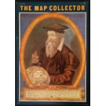
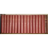
The Map Collector, numbers 1 - 74 (complete), December 1977 - Spring 1996, numerous colour and black & white illustrations throughout, all with or...

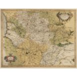
Wales. Blaeu (Johannes), Montgomeria comitatus et comitatus Mervinia [and] Dengigiensis comitatus et comitatus Flintensis; Denbigh et Flintshire, ...