Filtered by:
- Sale Section
- List
- Grid
A subscription to the Price Guide is required to view results for auctions ten days or older. Click here for more information


BEAUTIES : pair of female figures one with Chalybeate Spa in the background, and Brighton Chain Pier in the other. In most attractive bevelled gil...

BLAEU, Johannus : Levinia, vice Comitatus. The Province of Lennox, called the Shyre of Dun - Britton, hand coloured map of West Scotland, size : 5...

BUHOT, Flix - La Fete. Black & White engraving. 320 x 230 mm. 1878. F & G. ...[more]
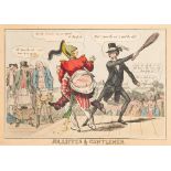
CARICATURES / POLITICAL CARTOONS : contemporary hand colouredetching ... " Jolliffes & Gentlemen," 350 x 250 mm (plate mark), no date or engraver....

Doyley, Thomas & William ? : hand coloured aquatint of an exotic Indian tree. Size : 440 x 330 mm (partially hidden under the frame), With five ot...
DANIELL,
DANIELL, William - (1749-1825) a collection of 13 hand coloured aquatints of scenes around the coast of Devon. 4 hand coloured aquatints of scenes...

DOVER CASTLE : Six tinted lithographs of Dover Castle A. D. 1642.Size : 430 x 310 mm, published by W. Burgess, Dover. * Civil War interest.

EUROPE : Map with attractive original full wash hand colouring by S. J. Neele 365 x 360 mm. circa 1800."Present Europe." With two others, and a fu...

FER, N.
FER, N. de - Les Iles Britaniques, on sont les Royaumes D'Angleterre' D'Escosse et D'Irland : uncoloured copper engraved map, 315 x 225 mm, attrac...
![LEWIS Frederick Christian [1813-1875] after Varley - St Albans Abbey from St Peters Street,](https://portal-images.azureedge.net/auctions-2022/bearne10117/images/5e906cda-daf8-4a1a-a475-af5200de3b99.jpg?w=155&h=155)
LEWIS Frederick Christian [1813-1875] after Varley -St Albans Abbey from St Peters Street, engraving, 29 x 28cm,:-together with a group of various...

FRITH, W.
FRITH, W. P - " An English Merry-Making in the Olden Time, :" large steel engraving by William Hole, 850 x 520 mm, in attractive gilt and wood fra...

FRITH, W. P - " Coming of Age in the Olden Times:." large steel engraving by F. Hull 900 x 570mm, Attractive wood and gilt frame. Light stain in l...

HAMMERSMITH BRIDGE : attractive hand coloured lithograph, published by Ackermann, 260 x 180 mm,
HAMMERSMITH BRIDGE : attractive hand coloured lithograph, published by Ackermann, 260 x 180 mm, F & G, 1828. With one other.(2)

HOGARTH, William: "Time of the Day", a set of four large copper plates 445 x 375 mm, three in Hogarth frames, one mounted,1738.

HOGARTH'S TOUR : 5 sepia copper engravings. 330 x 220 mm. vertical fold marks. 1781. With - 8 copper engravings mounted on linen, depicting 'low ...
WITHDRAWN LOT HOLE,
WITHDRAWN LOT HOLE, William - Comitatus Bercheriae vulgo Barkshyre [Berkshire] : hand coloured map, 390 x 275 mm, f & g, (1637).
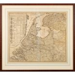
HOLLAND : Elwe, Ian Barend - Carte Generale des Provinces Unies des Pais Bale ... (etc). Hand coloured map. 580 x 500mm. 1792.(1)
![JANSSON, Jan - [ CHESHIRE ] Cestria Comitatus Palatinus.](https://portal-images.azureedge.net/auctions-2022/bearne10117/images/ca431a0a-d920-491b-b393-af4601525e07.jpg?w=155&h=155)
JANSSON, Jan - [ CHESHIRE ] Cestria Comitatus Palatinus. The Countre Palatine of Chester : hand coloured map, size : 480 x 360 mm, f & g, c1644. *...
JANSSON, Jan - Devoniae Descriptio. The Description of Devon-Shire : hand coloured map, size : 480 x 380 mm. F & G. circa 1646. * Lundy isn't show...
JANSSON, Jan - Middelsexiae cum Hertfordiae comitatu : Midlesex & Hertfordshire : hand coloured map,
JANSSON, Jan - Middelsexiae cum Hertfordiae comitatu : Midlesex & Hertfordshire : hand coloured map, 545 x 430 mm, F & Double G, c1644.
KEULEN G.
KEULEN G. Van - Compass Map of part of The East-Coast of England; extending from Eckles to Flamborough-Head containing the River of Hull; with the...
![KIP, William - [ Devonshire ] : Devoniae, hand coloured map with the number in the lower corner,](https://portal-images.azureedge.net/auctions-2022/bearne10117/images/a2e44751-b832-4655-ba1d-af4a010c4be2.jpg?w=155&h=155)
KIP, William - [ Devonshire ] : Devoniae, hand coloured map with the number in the lower corner,
KIP, William - [ Devonshire ] : Devoniae, hand coloured map with the number in the lower corner, 335 x 295 mm, 1637. Attractive f & g, Signs of we...
![KIP, William - [ Norfolk ] Norfolciae comitatus ... hand coloured map. 380 x 280 mm, F&G.](https://portal-images.azureedge.net/auctions-2022/bearne10117/images/cfad318b-ecfd-4ae1-be73-af4a010c4e35.jpg?w=155&h=155)
KIP, William - [ Norfolk ] Norfolciae comitatus ... hand coloured map. 380 x 280 mm, F&G. Plate number in bottom left-hand corner. ...[more]

LIZARS,W : Persia. engraved map with outline colouring. 475 x 380. In attractive wood frame.
LIZARS,W : Persia. engraved map with outline colouring. 475 x 380. In attractive wood frame. No date 19th cent.

MARTIN, Benjamin - The Natural History of England ... Illustrated by a map of each County : volume 2 (only) 19 folding county maps by Emanuel Bo...

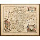
MERCATOR, Gerald - Cornubia, Devonia, Somersetus, Dorcesteria ... (et al) hand coloured map, 465 x 365. F&G. No date c1650 ? * Map of the whole of...

MORDEN Robert - Gloucester Shire : uncoloured map. 410 x 340 mm, f & g, c1695. With - Bowen, Emanuel. Devonshire Divided into its Hundreds. Hand c...

MORDEN Robert.
MORDEN Robert. A map of Hertfordshire, hand coloured map, 445 x 365mm, framed and glazed KEERE, Van Den, P - Hartforde Shire : hand coloured map, ...

MORDEN, Robert - Cornwall : hand coloured map, 430 x 345mm, quite foxed, F & G. c1695. ...[more]
![MORDEN, Robert - Cornwall : hand coloured map, F & G. 425 x 355 mm. 1722 [or earlier].](https://portal-images.azureedge.net/auctions-2022/bearne10117/images/eeef1537-b466-43de-8dbb-af4a010c574b.jpg?w=155&h=155)
MORDEN, Robert - Cornwall : hand coloured map, F & G. 425 x 355 mm. 1722 [or earlier].
![MORDEN, Robert - Devonshire : hand coloured map, 410 x 350 mm, F & G. 1722 [or earlier].](https://portal-images.azureedge.net/auctions-2022/bearne10117/images/755d3229-b98a-465e-a583-af4a010c58ec.jpg?w=155&h=155)
MORDEN, Robert - Devonshire : hand coloured map, 410 x 350 mm, F & G. 1722 [or earlier]. ...[more]
![MORDEN, Robert - Somersetshire : hand coloured map, 420 x 360 mm, F & G. 1722 [or earlier].](https://portal-images.azureedge.net/auctions-2022/bearne10117/images/c9ebc3b3-0e97-4ca5-8c73-af4a010c5ae7.jpg?w=155&h=155)
MORDEN, Robert - Somersetshire : hand coloured map, 420 x 360 mm, F & G. 1722 [or earlier]. ...[more]

MORDEN, Robet - Gloucestershire : hand coloured map. 415 x 340 mm. F & G. 1722 [or earlier] ...[more]
MOULE, Thomas - Devonshire : hand coloured map with vignette views, 250 x 180 mm. attractive gilt frames, c1830s. With 2 other maps, Westphalia, a...

OGILBY, John -- "The Road from Dartmouth in Com Devon to Minehead in Com Somerset," hand coloured road map, 435 x 325 mm, Attractive f & g, c1675....

OGILBY,
OGILBY, John - An Actual Survey of all he Principal Roads of |England and Wales; Described by One Hundred Maps from Copper Plates : .... now imp...
![OGILBY, John - London to Hith [Hythe] in com Kent,](https://portal-images.azureedge.net/auctions-2022/bearne10117/images/81b9781e-f79d-4431-9630-af4a010c60d1.jpg?w=155&h=155)
OGILBY, John - London to Hith [Hythe] in com Kent, Including the Road by Maidstone : hand coloured road map, size : 420 x 330 mm, f & g, some age ...

OGILBY, John - London to Oakeham. Hand coloured road map. 420 x 315 mm. F & G. Faint colouring.
OGILBY, John - London to Oakeham. Hand coloured road map. 420 x 315 mm. F & G. Faint colouring. 1675.

OGILBY, John - The Roads from London to Buckingham. Continued to Banbury .... hand coloured road map, size : 440 x 330 mm, some age discolouration...

" On the Course at Ascot.
" On the Course at Ascot." hand coloured line engraving, framed & glazed, circa 1900? With another rowing interest. With two engravings of "Beauti...

POWER, James P - London Old & New " Regent Street - Proof etching. 340 x 250 mm ...[more]

REYNOLDS, S.
REYNOLDS, S.W : large uncoloured steel engraved print of the Country Meeting of the Royal Agricultural Society of England. 1200 x 450 mm. No date ...

RIVER DART : 5 sepia aquatints, 240 x 117mm, All bar one are in Hogarth frames, 1820.

SATIRICAL/CARICATURES : ' Matrimonial Harmonics' Coloured print published by Le Petit, 335 x 225 mm,
SATIRICAL/CARICATURES : ' Matrimonial Harmonics' Coloured print published by Le Petit, 335 x 225 mm, framed and glazed (not examined out of frame....

SATIRICAL/CARICATURES : 'Dreadful Hot Weather,' by James Gillray, published by H. Humphrey, 1808.
SATIRICAL/CARICATURES : 'Dreadful Hot Weather,' by James Gillray, published by H. Humphrey, 1808. With three others similar.(4)

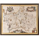
SPEED, John - Bedfordshire and the Situation of Bedford Described.: J. Humble. Hand coloured map.
SPEED, John - Bedfordshire and the Situation of Bedford Described.: J. Humble. Hand coloured map. 505 x 375mm. F&G in an;'Hogarth' framed and doub...
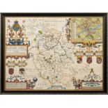
![SPEED, John - Hartford shire Described [Hertfordshire] hand coloured map, 510 x 380 mm.](https://portal-images.azureedge.net/auctions-2022/bearne10117/images/f8485931-d26a-4dd2-b9ad-af4a00f84dd4.jpg?w=155&h=155)
SPEED, John - Hartford shire Described [Hertfordshire] hand coloured map, 510 x 380 mm. Thomas Basset & Richard Chiswell Slight damage to the cent...
![SPEED, John - Wilshire : [ Wiltshire], hand coloured map, size : 500 x 380 mm, English text,](https://portal-images.azureedge.net/auctions-2022/bearne10117/images/8e37ff89-ed0f-41eb-ab27-af4a00f84e75.jpg?w=155&h=155)
SPEED, John - Wilshire : [ Wiltshire], hand coloured map, size : 500 x 380 mm, English text,
SPEED, John - Wilshire : [ Wiltshire], hand coloured map, size : 500 x 380 mm, English text, tear repaired. John Sudbury & G. Humble..F & G, circa...

SPIELMANN, Henriette Ronner : The Painter of Cat Life and Cat Character, org. cloth spine poor, portrait frontispiece, photogravure plates, lackin...

Sporting aquatint, 435 x 320 mm, in a Hogarth frame. * farmyard scene gentleman returning with a pheasant which he is about to give to his wife, ...

STONEHENGE : small sepia coloured etching, size 135 x 8.5 mm. F & G in a dark plain wood, circa 1920 * artists signature in pencil in the margin i...

SURVEY OF INDIA - A Military Traffic Map of India : large map on paper and folded with a few short
SURVEY OF INDIA - A Military Traffic Map of India : large map on paper and folded with a few short tears in margins and folds. Scale : one inch to...

TORTURE/STATE VIOLENCE/ETC : a folder containing mainly large 18th century engravings, including :-" Bambridge on Trial for Murder by a Committee ...

WESTALL, Richard : ( engraver ) A pair of hand coloured French mezzotints after Touvenin. Size : 530 x 400 mm. Titles, "Les Charmes De La Moisson"...

WYLD, James - A New Topographical Map of the Country in the Vicinity of London. Describing all the New Improvements. Metropolitan Boroughs and Par...

DEVON : a collection of loose maps, views, engravings from a number of different sources inc.
DEVON : a collection of loose maps, views, engravings from a number of different sources inc. Britton & Brayley, Senex, Winkles, Hollar, and panor...