

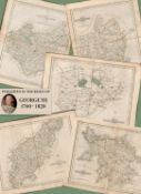
Title: Job-Lot of 14 Antique Steel Engraved 180 Years-Old Maps of Wales 1845.Description: Job-Lot of 14 Antique Steel Engraved 180 ...
614 item(s)
Filtered by:
- Category
- List
- Grid
-
614 item(s)/page

Title: Job-Lot of 4 Antique Steel Engraved 180 Years-Old Maps Yorkshire Ridings 1845.Description: Job-Lot of 4 Antique Steel Engrav...
Title: Job Lot John Cary’s 1787 Antique Hand Coloured 235 Years-Old Map.Description: Job Lot John Cary’s 1787 Antique Hand Coloured 235 Years...

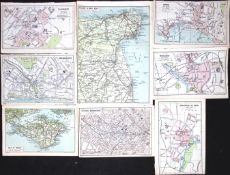
Title: Collection 9 Vintage George Bacon London & Suburbs Large Scale MapsDescription: Collection 9 Vintage George Bacon London & Suburbs Lar...

Title: Collection of 12 King George III 233 Years-Old John Cary Town Maps.Description: Collection of 12 King George III 233 Years-Old John Ca...
Title: Large Collection 25 English Cities, Towns, Counties, Etc Detailed & Coloured Antique Maps.Description: Large Collection 25 English Ci...

Title: The Environs of London Detailed Coloured Mounted Antique Map.Description: The Environs of London Detailed Coloured Mounted A...

Title: London Iconic District The East End Mounted Coloured Antique Map.Description: London Iconic District The East End Mounted An...

Title: London District Canning Town & Woolwich Mounted Antique Map.Description: London District Canning Town & Woolwich Mounted Ant...

Title: London District Charing Cross & London Docks Mounted Antique Map.Description: London District Charing Cross & London Docks M...

Title: London District Woolwich & Plumstead Mounted Antique Map.Description: London District Woolwich & Plumstead Mounted Antique M...

Title: London District Kew, Richmond & Kingston Mounted Coloured Antique Map.Description: London District Kew, Richmond & Kingston Mounted An...

Title: Mail Road London To Holyhead King George IV 198 Years-Old Antique Map.Description: Mail Road London To Holyhead King George IV 198 ...

Title: Route New Shoreham To Chichester & Fareham 197 Year-Old Antique Map.Description: Route New Shoreham To Chichester & Fareham 197 Year-O...

Title: Isle Of Thanet & Adjacent County Kent King George IV 197 Years-Old Antique Map.Description: Isle Of Thanet & Adjacent County Kent Kin...
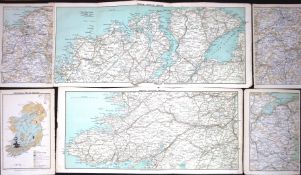
Title: Large Collection 22 Irish Cities, Counties, Provinces Detailed & Coloured Antique Maps.Description: Large Collection 22 Irish Cities, ...
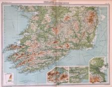
Title: Antique Bartholomew Large Map Ireland Southern Section Dublin Cork Kerry.Description: Antique Bartholomew Map Ireland Southe...

Title: Antique John Bartholomew The Mapping of the World Large Large Map.Description: Antique John Bartholomew The Mapping of the World Large...

EARLY ORIGINAL MAP OF ANGLESEY, APPROXIMATELY 24 x 35cm reasonable used condition

Lot 235
Quantity of various One-Inch & Ordnance Survey maps - various places in the UK ALL USED UNCHECKED
235Quantity of various One-Inch & Ordnance Survey maps - various places in the UK ALL USED UNCHECKED
Quantity of various One-Inch & Ordnance Survey maps - various places in the UK ALL USED UNCHECKED

The Royal Geographical Society hall marked silver map of the World

Map of Warwickshire following Rocque 1769, together with a map of Jersey

A selection of Ordnance Survey maps

Lot 191
Two views of the Holy sites of Islam : the Masjid al-Haram at Mecca and the Masjid al-Nabawi at M...
Two views of the Holy sites of Islam : the Masjid al-Haram at Mecca and the Masjid al-Nabawi at Medina, India, early 20th century, Opaque pigment...

Lot 246
Highland School, a pair of colour prints, one titled Summer Isles, 249/250, 15cm x 40cm, framed
Highland School, a pair of colour prints, one titled Summer Isles, 249/250, 15cm x 40cm, framed

Lot 307
A selection of assorted Ordance Survey maps, a framed West Riding print with assorted town maps,
A selection of assorted Ordance Survey maps, a framed West Riding print with assorted town maps, shipping unavailable

Lot 475
A map of the County of Bedford after C Smith, 2nd edition 1808, hand coloured, 49cm x 44cm, oak fram
A map of the County of Bedford after C Smith, 2nd edition 1808, hand coloured, 49cm x 44cm, oak framed and glazed

Assorted maps, pictures and other prints (qty)


A framed map, and a gilded leaf and slate artwork.

Lot 2417
A large antique map of Worcester.
A large antique map of Worcester.
Lot 49
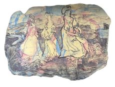
Ann Froshaug (British, 20th century). "The Three Graces", acrylic washed crank clay, 30x42cm.
Ann Froshaug (British, 20th century). "The Three Graces", acrylic washed crank clay, 30x42cm.
![After Christopher Saxton and Philip Lea, a hand-coloured engraved map of 'Glocestershire' [sic],](https://portal-images.azureedge.net/auctions-2025/whpav12190/images/c43f84c3-fa6b-42c4-bd5f-b2c301157fc5.jpg?h=175)
Lot 108
After Christopher Saxton and Philip Lea, a hand-coloured engraved map of 'Glocestershire' [sic],
After Christopher Saxton and Philip Lea,a hand-coloured engraved map of 'Glocestershire' [sic],image 38 x 49 cm

After Pieter van der Aa (Dutch, 1659-1733),'Latium Campania et Samnium cum Forum Circum Adjacentibus Regionibus',hand-coloured engraved map,image ...

Lot 111
After S. Bellin, 'Carte Du Comté De Kent Et Du Pas De Calais', hand-coloured engraved map, image
After S. Bellin,'Carte Du Comté De Kent Et Du Pas De Calais',hand-coloured engraved map,image 60 x 90 cm

Lot 114
A needlework map of Engalnd & Wales by Lucy Elizabeth Depeat, aged 9, 1890, image 73 x 73 cm,
A needlework map of Engalnd & Wales by Lucy Elizabeth Depeat, aged 9, 1890, image 73 x 73 cm, together with another similar map (2)

Rare Antique Georgian Cartographer’s Étui, Navigation Map Drafting Kit, Original 1760-1790 together with the Captain Hook Magnifier with original ...

Early 19th century hand coloured map by James Knox C1821. Frame- 73x88cm

Lot 339
Abraham Ortelius (1527-1598) 1601 Original Copperplate map of Burgundy Details to the reverse side
Abraham Ortelius (1527-1598) 1601 Original Copperplate map of Burgundy Details to the reverse side of the map. Frame- 47.5x60cm

Lot 860
Leighs Road Book of England and Wales, London 1887 and two other maps in slip cases depicting
Leighs Road Book of England and Wales, London 1887 and two other maps in slip cases depicting Glasgow and the Environs.

Selection of eleven bottles of commemoratives ales

Lot 48
Johann Babtiste Homann (1664 - 1724, Nürnberg) - Landkarte Kaspisches Meer und Kamtschatka, um 1720
Johann Babtiste Homann (1664 - 1724, Nürnberg) - Landkarte Kaspisches Meer und Kamtschatka, um 1720Mare Caspium altera Kamtzadaliam seu Terram Jed...


Coloured print on paper, depicting prayers around the Kabaa in al-Masjid al-Haram. 47 by 37 cm. 40 by 30 cm.

Up at the O2 Family Climb Experience for 2 Adults and 2 Children - Bid for an unforgettable adventure! Climb the iconic O2 Arena and enjoy breatht...

The Ship Inn, Red Wharf Bay Anglesey £100 voucher - Enjoy £100 to spend at The Ship Inn, a stunning seaside pub overlooking Red Wharf Bay. Famous ...

Lot 58
Newly renovated, not yet on the market holiday home in Anglesey Located on the inland coast in
Newly renovated, not yet on the market holiday home in Anglesey Located on the inland coast in Anglesey, Wales. This 2 bed bungalow would be avai...

Lot 120
A large quantity of early 20th century Ordnance Survey maps, to include Carmarthen, St. David's &
120A large quantity of early 20th century Ordnance Survey maps, to include Carmarthen, St. David's &
A large quantity of early 20th century Ordnance Survey maps, to include Carmarthen, St. David's & Cardigan, Brecon & Llandovery, Abergavenny, Glou...

Lot 132
Two boxes containing various vintage Ordnance Survey maps, to include Loch Lomond, Bradford,
Two boxes containing various vintage Ordnance Survey maps, to include Loch Lomond, Bradford, Bolton ect, over 100

A group of 7 blue binders holding various ordnance survey maps of Great Britain, (7)

Lot 190
Two boxes containing various Ordnance Survey maps of the UK, to include Preston and Blackpool,
Two boxes containing various Ordnance Survey maps of the UK, to include Preston and Blackpool, Askrigg & Settle and Selkirk, over 100 maps

North Eastern Railway Plans & Sections Session 1889, Sheet No 1 & 2, Railway No 2, No 3, Additional Lines, Land to be Taken, Land on Blyth and Tyn...

Lot 370
A beautiful signed limited edition print by Jeremy King, Punting on the Cambridge river, 241 of 250,
A beautiful signed limited edition print by Jeremy King, Punting on the Cambridge river, 241 of 250, frame size 81 x 62cm

Lot 84
A collection of three possibly 17th century engraved and hand coloured maps of Surrey by John Norden
A collection of three possibly 17th century engraved and hand coloured maps of Surrey by John Norden & William Kip, John Speed, and Michael Drayto...

Lot 86
Two hand coloured and engraved maps to include one possibly late 17th century titled 'The Road
Two hand coloured and engraved maps to include one possibly late 17th century titled 'The Road from London to Portsmouth in com Southamp.' by John...

Lot 87
A collection of three possibly 17th century and later hand coloured maps of Esher and Surrey by G.R.
A collection of three possibly 17th century and later hand coloured maps of Esher and Surrey by G.R. Haybittle, John Speed, and Thomas Moule respe...

Lot 133
A Tannoy sub woofer. Disclaimer: electrical items are sold as untested and without guarantee.
A Tannoy sub woofer. Disclaimer: electrical items are sold as untested and without guarantee.

C1720 Latium Campania et Samnium by AA, Pieter van der - Map engraving of ancient Italy with later colouring, framed and glazed. Complete with cer...

1967 coloured print of Saxton's Map of Somerset, 1575 by Taylowe Limited. Framed and glazed, measuring approx. 53.5cm x 65.5cm.

Lot 449
An antique map of Scotland, dated 1821 and engraved for Dr Playfair's Atlas, published by Macredie
An antique map of Scotland, dated 1821 and engraved for Dr Playfair's Atlas, published by Macredie Skelly & Co of Edinburgh, 1821, 69cm x 58cm