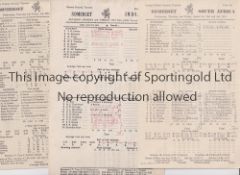
No Image Lot 896 SOMERSET C.C.C. Over 110 home and away scorecards, 82 from the 1950's including v Australia 1953 and 896SOMERSET C.C.C. Over 110 home and away scorecards, 82 from the 1950's including v Australia 1953 and Sportingold Limited SOMERSET C.C.C. Over 110 home and away scorecards, 82 from the 1950's including v Australia 1953 and 1956, Pakistan 1954, India 1959, West I... Live
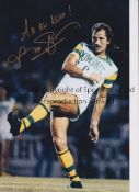
No Image Lot 1266 FRANK WORTHINGTON Autographed 12 x 8 col photo of Worthington in full length action for the Tampa 1266FRANK WORTHINGTON Autographed 12 x 8 col photo of Worthington in full length action for the Tampa Sportingold Limited FRANK WORTHINGTON Autographed 12 x 8 col photo of Worthington in full length action for the Tampa Bay Rowdies, c1981, signed All The Best in ... Live
No Image Lot 3500 END OF SALE, THANK YOU FOR YOUR BIDDING. OUR NEXT SALE IS ON THE WEDNESDAY 14TH AND THURSDAY 15TH 3500END OF SALE, THANK YOU FOR YOUR BIDDING. OUR NEXT SALE IS ON THE WEDNESDAY 14TH AND THURSDAY 15TH Ashley Waller Auctioneers END OF SALE, THANK YOU FOR YOUR BIDDING. OUR NEXT SALE IS ON THE WEDNESDAY 14TH AND THURSDAY 15TH MAY Add to watchlist Live
No Image Lot 445 Rare County Galway Manuscript Map Map: Co. Galway - [Logan (Michael) cartographer] A Survey of the 445Rare County Galway Manuscript Map Map: Co. Galway - [Logan (Michael) cartographer] A Survey of the Fonsie Mealy Auctioneers Rare County Galway Manuscript Map Map: Co. Galway - [Logan (Michael) cartographer] A Survey of the Lands of Pallase and Ballydoogan situate in the... Add to watchlist Live
No Image Lot 547 Northampton: Kip (Wm.) Northamtoniae Comitatus Descritio, c. 1690, hd. cold.in outline; Morden ( 547Northampton: Kip (Wm.) Northamtoniae Comitatus Descritio, c. 1690, hd. cold.in outline; Morden ( Fonsie Mealy Auctioneers Northampton: Kip (Wm.) Northamtoniae Comitatus Descritio, c. 1690, hd. cold.in outline; Morden (Rob.) Northamptonshire, dbl. page engd. & folding ... Add to watchlist Live
No Image Lot 549 Irish Map: Whigham (Rev. James) Presbyterian Map of Ireland, c. 1888, ornamented with various 549Irish Map: Whigham (Rev. James) Presbyterian Map of Ireland, c. 1888, ornamented with various Fonsie Mealy Auctioneers Irish Map: Whigham (Rev. James) Presbyterian Map of Ireland, c. 1888, ornamented with various motifs, etc., approx. 87cms x 73cms (34" x 28 1/2") ... Add to watchlist Live
No Image Lot 462 A large Early 20th Century Irish advertising poster. With the map of Belfast District and local 462A large Early 20th Century Irish advertising poster. With the map of Belfast District and local Locke's Auctioneers & Valuers (Laganside) A large Early 20th Century Irish advertising poster. With the map of Belfast District and local businesses. Circa 1915-1918. Issue 2158. J. W. Har... Add to watchlist Live
No Image Lot 574 Cuala Press Limited. An Old Woman of The Roads by Padraic Colum. Coloured print. 30x40cm 574Cuala Press Limited. An Old Woman of The Roads by Padraic Colum. Coloured print. 30x40cm Locke's Auctioneers & Valuers (Laganside) Cuala Press Limited. An Old Woman of The Roads by Padraic Colum. Coloured print. 30x40cm Add to watchlist Live
No Image Lot 157 SEVEN BOTTLES OF COURAGE SILVER JUBILEE ALE, 157SEVEN BOTTLES OF COURAGE SILVER JUBILEE ALE, McTear's SEVEN BOTTLES OF COURAGE SILVER JUBILEE ALE, 1977 Add to watchlist Live
No Image Lot 594 Mangalore Series of Object Lesson Charts: Indian Scenaries 594Mangalore Series of Object Lesson Charts: Indian Scenaries Vectis Auctions Ltd Mangalore Series of Object Lesson Charts: Indian Scenaries (Printed in Germany), vintage educational items, published by the Basel Mission Press a... Add to watchlist Live
No Image Lot 4153 JULIAN CHICHESTER, a 'Tassia' lamp, green colourway glass, on lucite base, 62.5cm high (1) 4153JULIAN CHICHESTER, a 'Tassia' lamp, green colourway glass, on lucite base, 62.5cm high (1) Ewbank's JULIAN CHICHESTER, a 'Tassia' lamp, green colourway glass, on lucite base, 62.5cm high (1) Condition Report: Overall domestic w... Add to watchlist Live
No Image Lot 4167 HAACK GOTHA, Map of London, scale 1:10,000, paper on linen, printed to the margin, 4167HAACK GOTHA, Map of London, scale 1:10,000, paper on linen, printed to the margin, Ewbank's HAACK GOTHA, Map of London, scale 1:10,000, paper on linen, printed to the margin, Veb Hermann Haak, Geographisch-Kartographische Astalt G... Add to watchlist Live
No Image Lot 4169 GEORGE PHILLIPS AND SONS, Phillips School Room Map of the World, on Mercators projection, showing.. 4169GEORGE PHILLIPS AND SONS, Phillips School Room Map of the World, on Mercators projection, showing.. Ewbank's GEORGE PHILLIPS AND SONS, Phillips School Room Map of the World, on Mercators projection, showing.., 1963, issued by the London Geographi... Add to watchlist Live
No Image Lot 130 AN AUSTRALIAN GEOGRAPHIC GLOBE. 130AN AUSTRALIAN GEOGRAPHIC GLOBE. Horners Valuers & Auctioneers AN AUSTRALIAN GEOGRAPHIC GLOBE. Add to watchlist Live
No Image Lot 309 An 18th century map of Worcester, showing the Digliss and Pitchcroft, J.Doharty 1741 309An 18th century map of Worcester, showing the Digliss and Pitchcroft, J.Doharty 1741 Philip Serrell An 18th century map of Worcester, showing the Digliss and Pitchcroft, J.Doharty 1741 Add to watchlist Live
No Image Lot 330 An antique map of Sussex 330An antique map of Sussex Philip Serrell An antique map of Sussex Add to watchlist Live
No Image Lot 371 A copy of the Madonna 'Sex' book, in original foil outer wrapper. Condition Report: Foil wrapper 371A copy of the Madonna 'Sex' book, in original foil outer wrapper. Condition Report: Foil wrapper Adam Partridge Auctioneers & Valuers A copy of the Madonna 'Sex' book, in original foil outer wrapper.Condition Report: Foil wrapper is in worn condition, with folds and scratches and... Add to watchlist Live
No Image Lot 408 A group of Second World War Ordnance Survey revision and other military maps of Great Britain 408A group of Second World War Ordnance Survey revision and other military maps of Great Britain Laidlaw Auctioneers & Valuers A group of Second World War Ordnance Survey revision and other military maps of Great Britain Add to watchlist Live
No Image Lot 426 A 1950'S "TOWN" CREATION COAT STYLED BY HELEN VAN VLIET. 426A 1950'S "TOWN" CREATION COAT STYLED BY HELEN VAN VLIET. Horners Valuers & Auctioneers A 1950'S "TOWN" CREATION COAT STYLED BY HELEN VAN VLIET. Add to watchlist Live
No Image Lot 499 GWR; a vintage advertising route map for the South West of the UK, 25 x 74.5cm, framed and glazed. 499GWR; a vintage advertising route map for the South West of the UK, 25 x 74.5cm, framed and glazed. Adam Partridge Auctioneers & Valuers GWR; a vintage advertising route map for the South West of the UK, 25 x 74.5cm, framed and glazed. Add to watchlist Live
No Image Lot 524 Thomas Hodgson, a map of Westmorland, London, W R Gardener, 1828, engraved and watercolour tinted, 524Thomas Hodgson, a map of Westmorland, London, W R Gardener, 1828, engraved and watercolour tinted, Laidlaw Auctioneers & Valuers Thomas Hodgson, a map of Westmorland, London, W R Gardener, 1828, engraved and watercolour tinted, dissected and laid on cotton, in calf book-form... Add to watchlist Live
No Image Lot 525 "Map of the County of Westmorland from an Actual Survey made in The Years 1822 & 1823 by C & J 525"Map of the County of Westmorland from an Actual Survey made in The Years 1822 & 1823 by C & J Laidlaw Auctioneers & Valuers "Map of the County of Westmorland from an Actual Survey made in The Years 1822 & 1823 by C & J Greenwood. Most Respectfully Dedicated to the Nobil... Add to watchlist Live
No Image Lot 528 A large quantity of contemporary Ordnance Survey maps of Great Britain, largely Cumbria / Lake 528A large quantity of contemporary Ordnance Survey maps of Great Britain, largely Cumbria / Lake Laidlaw Auctioneers & Valuers A large quantity of contemporary Ordnance Survey maps of Great Britain, largely Cumbria / Lake District Add to watchlist Live
No Image Lot 529 A group of late 19th Century and other maps of Great Britain, including cloth-backed examples 529A group of late 19th Century and other maps of Great Britain, including cloth-backed examples Laidlaw Auctioneers & Valuers A group of late 19th Century and other maps of Great Britain, including cloth-backed examples published by the Ordnance Survey Office, John Bartho... Add to watchlist Live
No Image Lot 797 A tin of J Huthart & Co Hosiers & General Drapers of Carlisle Superior Pins, late 19th / early 797A tin of J Huthart & Co Hosiers & General Drapers of Carlisle Superior Pins, late 19th / early Laidlaw Auctioneers & Valuers A tin of J Huthart & Co Hosiers & General Drapers of Carlisle Superior Pins, late 19th / early 20th Century, 11 cm x 7 cm x 2.5 cm Add to watchlist Live
No Image Lot 1366 Framed 'Keep Mum, She's Not Dumb' poster, two unframed Spanish posters and four similar maps (7) 1366Framed 'Keep Mum, She's Not Dumb' poster, two unframed Spanish posters and four similar maps (7) Ryedale Auctioneers Framed 'Keep Mum, She's Not Dumb' poster, two unframed Spanish posters and four similar maps (7) Shipping POA https://www.bradleys.ltd/quotation-r... Add to watchlist Live
No Image Lot 1624 An assortment of various pictures including map of Huntingdonshire, oriental print, floral still 1624An assortment of various pictures including map of Huntingdonshire, oriental print, floral still W&H Peacock Auctioneers & Valuers An assortment of various pictures including map of Huntingdonshire, oriental print, floral still life, tapestries etc. Add to watchlist Live
No Image Lot 1649 5 black and gilt framed maps incl. street plan of St. Neots, 1635 map of the British Isles by Willem 16495 black and gilt framed maps incl. street plan of St. Neots, 1635 map of the British Isles by Willem W&H Peacock Auctioneers & Valuers 5 black and gilt framed maps incl. street plan of St. Neots, 1635 map of the British Isles by Willem & Johan Blaeu, similar map of Middlesex, Lanc... Add to watchlist Live
No Image Lot 140 A motorcycle rider 'Henk Van Zalinge' The renowned inventor of the Z-Bass, overpainted print 29" 140A motorcycle rider 'Henk Van Zalinge' The renowned inventor of the Z-Bass, overpainted print 29" Amersham Auction Rooms A motorcycle rider 'Henk Van Zalinge' The renowned inventor of the Z-Bass, overpainted print 29" x 19" framed Add to watchlist Live
No Image Lot 181 A green and tan holdall and a souvenir tea towel printed with an ordnance survey map of 181A green and tan holdall and a souvenir tea towel printed with an ordnance survey map of Morphets of Harrogate A green and tan holdall and a souvenir tea towel printed with an ordnance survey map of Scarborough c. 1947 and a Olympus Super Zoom 120 camera an... Add to watchlist Live
No Image Lot 298 J Cary, a map of the North Riding of Yorkshire with later hand tinting, with compass and list of 298J Cary, a map of the North Riding of Yorkshire with later hand tinting, with compass and list of Morphets of Harrogate J Cary, a map of the North Riding of Yorkshire with later hand tinting, with compass and list of wapentakes, 41cm x 73cm and J Cary, an engraved m... Add to watchlist Live
No Image Lot 537 An Aquascutum ale blue wool cloth jacket and skirt c.1985-90, size 18 537An Aquascutum ale blue wool cloth jacket and skirt c.1985-90, size 18 Morphets of Harrogate An Aquascutum ale blue wool cloth jacket and skirt c.1985-90, size 18 Add to watchlist Live
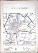
Reserve not met No Image Lot 1 London Guildford Boundary Commission 157-Year-Old Coloured Scarce Antique Map. 1London Guildford Boundary Commission 157-Year-Old Coloured Scarce Antique Map. William George Title: London Guildford Boundary Commission 157-Year-Old Coloured Scarce Antique Map.Description: Original Antique Lithograph Map Taken from ... Add to watchlist Timed
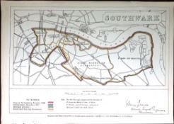
Reserve not met No Image Lot 2 London Southwark Boundary Commission 157-Year-Old Coloured Antique Map. 2London Southwark Boundary Commission 157-Year-Old Coloured Antique Map. William George Title: London Southwark Boundary Commission 157-Year-Old Coloured Antique Map.Description: Original Antique Lithograph Map Taken from a First... Add to watchlist Timed
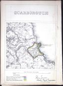
Reserve not met No Image Lot 3 Scarborough Yorkshire Boundary Commission Coloured 157-Year-Old Antique Map. 3Scarborough Yorkshire Boundary Commission Coloured 157-Year-Old Antique Map. William George Title: Scarborough Yorkshire Boundary Commission Coloured 157-Year-Old Antique Map.Description: Original Antique Lithograph Map Taken from a ... Add to watchlist Timed
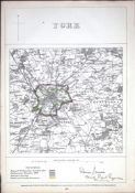
Reserve not met No Image Lot 4 York Yorkshire Boundary Commission 157-Year-Old Coloured Scarce Antique Map. 4York Yorkshire Boundary Commission 157-Year-Old Coloured Scarce Antique Map. William George Title: York Yorkshire Boundary Commission 157-Year-Old Coloured Scarce Antique Map.Description: Original Antique Lithograph Map Taken from a ... Add to watchlist Timed
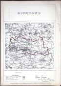
Reserve not met No Image Lot 5 Richmond Yorkshire Boundary Commission Coloured 157-Year-Old Antique Map. 5Richmond Yorkshire Boundary Commission Coloured 157-Year-Old Antique Map. William George Title: Richmond Yorkshire Boundary Commission Coloured 157-Year-Old Antique Map.Description: Original Antique Lithograph Map Taken from a Fir... Add to watchlist Timed
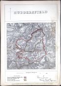
Reserve not met No Image Lot 6 Huddersfield Yorkshire Boundary Commission 157-Year-Old Coloured Antique Map. 6Huddersfield Yorkshire Boundary Commission 157-Year-Old Coloured Antique Map. William George Title: Huddersfield Yorkshire Boundary Commission 157-Year-Old Coloured Antique Map.Description: Original Antique Lithograph Map Taken from a... Add to watchlist Timed
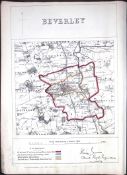
Reserve not met No Image Lot 7 Beverley Yorkshire Boundary Commission Coloured 157-Year-Old Antique Map. 7Beverley Yorkshire Boundary Commission Coloured 157-Year-Old Antique Map. William George Title: Beverley Yorkshire Boundary Commission Coloured 157-Year-Old Antique Map.Description: Original Antique Lithograph Map Taken from a Fir... Add to watchlist Timed
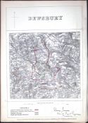
Reserve not met No Image Lot 8 Dewsbury Yorkshire Boundary Commission 157-Year-Old Scarce Antique Map. 8Dewsbury Yorkshire Boundary Commission 157-Year-Old Scarce Antique Map. William George Title: Dewsbury Yorkshire Boundary Commission 157-Year-Old Scarce Antique Map.Description: Original Antique Lithograph Map Taken from a First... Add to watchlist Timed
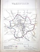
Reserve not met No Image Lot 9 Wakefield Yorkshire Boundary Commission 157-Year-Old Antique Map. 9Wakefield Yorkshire Boundary Commission 157-Year-Old Antique Map. William George Title: Wakefield Yorkshire Boundary Commission 157-Year-Old Antique Map.Description: Original Antique Lithograph Map Taken from a First Editi... Add to watchlist Timed
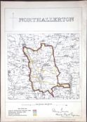
Reserve not met No Image Lot 10 Northallerton Yorkshire Boundary Commission 157-Year-Old Coloured Antique Map. 10Northallerton Yorkshire Boundary Commission 157-Year-Old Coloured Antique Map. William George Title: Northallerton Yorkshire Boundary Commission 157-Year-Old Coloured Antique Map.Description: Original Antique Lithograph Map Taken from ... Add to watchlist Timed
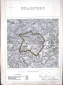
Reserve not met No Image Lot 11 Bradford City Yorkshire Boundary Commission 157-Year-Old Antique Map. 11Bradford City Yorkshire Boundary Commission 157-Year-Old Antique Map. William George Title: Bradford City Yorkshire Boundary Commission 157-Year-Old Antique Map.Description: Original Antique Lithograph Map Taken from a First E... Add to watchlist Timed
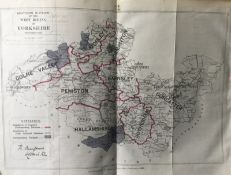
Reserve not met No Image Lot 12 Antique 139 Years-Old Scarce Map South West Riding Yorkshire 1885 12Antique 139 Years-Old Scarce Map South West Riding Yorkshire 1885 William George Title: Antique 139 Years-Old Scarce Map South West Riding Yorkshire 1885Description: Zincographed Ordnance Survey Map Produced by Colonel R. ... Add to watchlist Timed
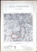
Reserve not met No Image Lot 14 Stalybridge Manchester Boundary Commission Coloured 157-Year-Old Antique Map. 14Stalybridge Manchester Boundary Commission Coloured 157-Year-Old Antique Map. William George Title: Stalybridge Manchester Boundary Commission Coloured 157-Year-Old Antique Map.Description: Original Antique Lithograph Map Taken from a... Add to watchlist Timed
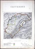
Reserve not met No Image Lot 15 Clitheroe Lancashire Boundary Commission 157-Year-Old Coloured Antique Map. 15Clitheroe Lancashire Boundary Commission 157-Year-Old Coloured Antique Map. William George Title: Clitheroe Lancashire Boundary Commission 157-Year-Old Coloured Antique Map.Description: Original Antique Lithograph Map Taken from a F... Add to watchlist Timed
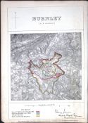
Reserve not met No Image Lot 16 Burnley Lancashire Boundary Commission 157-Year-Old Coloured Antique Map. 16Burnley Lancashire Boundary Commission 157-Year-Old Coloured Antique Map. William George Title: Burnley Lancashire Boundary Commission 157-Year-Old Coloured Antique Map.Description: Original Antique Lithograph Map Taken from a Fir... Add to watchlist Timed
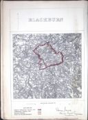
Reserve not met No Image Lot 17 Blackburn Lancashire Boundary Commission 157-Year-Old Antique Map. 17Blackburn Lancashire Boundary Commission 157-Year-Old Antique Map. William George Title: Blackburn Lancashire Boundary Commission 157-Year-Old Antique Map.Description: Original Antique Lithograph Map Taken from a First Edit... Add to watchlist Timed
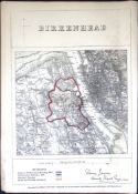
Reserve not met No Image Lot 18 Birkenhead Merseyside Boundary Commission 157-Year-Old Coloured Antique Map 18Birkenhead Merseyside Boundary Commission 157-Year-Old Coloured Antique Map William George Title: Birkenhead Merseyside Boundary Commission 157-Year-Old Coloured Antique MapDescription: Original Antique Lithograph Map Taken from a F... Add to watchlist Timed
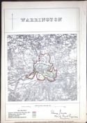
Reserve not met No Image Lot 19 Warrington Lancashire Boundary Commission 157-Year-Old Scarce Antique Map. 19Warrington Lancashire Boundary Commission 157-Year-Old Scarce Antique Map. William George Title: Warrington Lancashire Boundary Commission 157-Year-Old Scarce Antique Map.Description: Original Antique Lithograph Map Taken from a Fi... Add to watchlist Timed
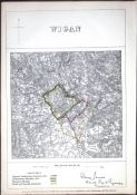
Reserve not met No Image Lot 20 Wigan Lancaster Boundary Commission 157-Year-Old Scarce Antique Map. 20Wigan Lancaster Boundary Commission 157-Year-Old Scarce Antique Map. William George Title: Wigan Lancaster Boundary Commission 157-Year-Old Scarce Antique Map.Description: Original Antique Lithograph Map Taken from a First Ed... Add to watchlist Timed
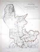
Reserve not met No Image Lot 21 North Lancashire Boundary Commission 157-Year-Old Large Antique Coloured Map. 21North Lancashire Boundary Commission 157-Year-Old Large Antique Coloured Map. William George Title: North Lancashire Boundary Commission 157-Year-Old Large Antique Coloured Map.Description: Original Antique Lithograph Map Taken from a... Add to watchlist Timed
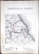
Reserve not met No Image Lot 22 Berwick Upon Tweed Northumberland Boundary Commission 157-Year-Old Antique Map. 22Berwick Upon Tweed Northumberland Boundary Commission 157-Year-Old Antique Map. William George Title: Berwick Upon Tweed Northumberland Boundary Commission 157-Year-Old Antique Map.Description: Original Antique Lithograph Map Taken from... Add to watchlist Timed
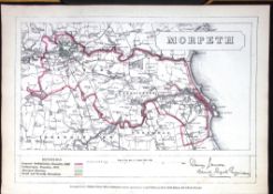
Reserve not met No Image Lot 23 Morpeth Northumberland Boundary Commission 157-Year-Old Antique Map. 23Morpeth Northumberland Boundary Commission 157-Year-Old Antique Map. William George Title: Morpeth Northumberland Boundary Commission 157-Year-Old Antique Map.Description: Original Antique Lithograph Map Taken from a First Ed... Add to watchlist Timed
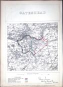
Reserve not met No Image Lot 24 Gateshead Tyne & Wear Boundary Commission 157-Year-Old Antique Map. 24Gateshead Tyne & Wear Boundary Commission 157-Year-Old Antique Map. William George Title: Gateshead Tyne & Wear Boundary Commission 157-Year-Old Antique Map.Description: Original Antique Lithograph Map Taken from a First Edi... Add to watchlist Timed
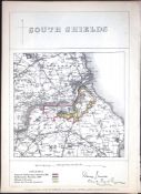
Reserve not met No Image Lot 25 South Shields Tyne & Wear Boundary Commission Coloured 157-Year-Old Antique Map 25South Shields Tyne & Wear Boundary Commission Coloured 157-Year-Old Antique Map William George Title: South Shields Tyne & Wear Boundary Commission Coloured 157-Year-Old Antique MapDescription: Original Antique Lithograph Map Taken from... Add to watchlist Timed
Reserve not met No Image Lot 26 Sunderland Tyne & Wear Boundary Commission 157-Year-Old Coloured Antique Map. 26Sunderland Tyne & Wear Boundary Commission 157-Year-Old Coloured Antique Map. William George Title: Sunderland Tyne & Wear Boundary Commission 157-Year-Old Coloured Antique Map.Description: Original Antique Lithograph Map Taken from a... Add to watchlist Timed
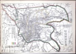
Reserve not met No Image Lot 27 Durham Boundary Commission 157-Year-Old Coloured Scarce Antique Map. 27Durham Boundary Commission 157-Year-Old Coloured Scarce Antique Map. William George Title: Durham Boundary Commission 157-Year-Old Coloured Scarce Antique Map.Description: Original Antique Lithograph Map Taken from a First Ed... Add to watchlist Timed
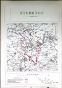
Reserve not met No Image Lot 28 Stockton-Durham Boundary Commission Coloured 157-Year-Old Antique Map. 28Stockton-Durham Boundary Commission Coloured 157-Year-Old Antique Map. William George Title: Stockton-Durham Boundary Commission Coloured 157-Year-Old Antique Map.Description: Original Antique Lithograph Map Taken from a First ... Add to watchlist Timed


![Rare County Galway Manuscript Map Map: Co. Galway - [Logan (Michael) cartographer] A Survey of the](https://portal-images.azureedge.net/auctions-2025/srfons10072/images/e595a198-6501-4c21-9cd9-b2ba00d0b16e.jpg?h=175)