We found 301 price guide item(s) matching your search
There are 301 lots that match your search criteria. Subscribe now to get instant access to the full price guide service.
Click here to subscribe- List
- Grid
-
301 item(s)/page

![Cooke (George Alexander) Topographical and Statistical Description of the County of York, Printed for C. Cooke, [c.1810]. 8vo](https://cdn.globalauctionplatform.com/4102523d-e7ad-401c-b027-a96c010bc098/13a7b4f7-8c5f-4c45-81da-a9b400c29ab8/468x382.jpg)
Lot 64
Cooke (George Alexander) Topographical and Statistical Description of the County of York, Printed for C. Cooke, [c.1810]. 8vo, full contemporary marbled calf, flat spine ruled in gilt with contrasting morocco lettering-piece; four folding maps after John Cary and letterpress tables to text. Despite the dry name this is a guidebook to Yorkshire from Charles Cooke's series. It includes dates of fairs, itineraries of roads and intriguing local history.Very slight scuffing to board edges, some spotting internally, but a very good copy in an attractive binding.
Lot 356
A Quantity of Model Railway Catalogues and Guidance Books, including Triang-Hornby/Hornby catalogues from 12th edition to 31st complete, with T-H 'Ten Years on' and 25th anniversary Books of Trains, catalogues by Wrenn, Graham Farish and others, and assorted books on building layouts and stock, together with an original 'Hornby Railway Company' guidebook and membership certificate dated 14th October 1940, varying F-VG
Lot 104
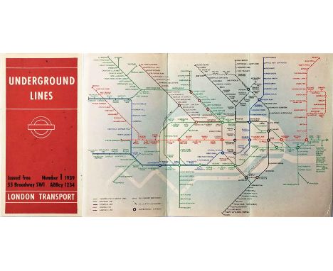
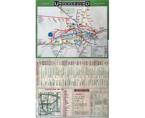
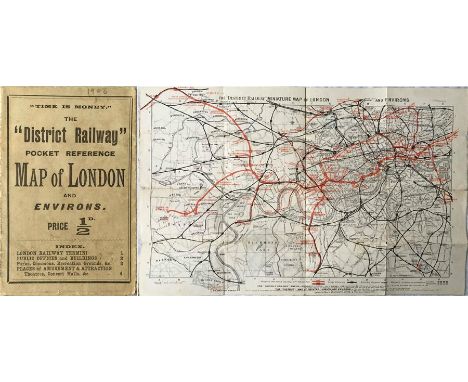
1908 District Railway POCKET REFERENCE MAP OF LONDON. This was the DR's version of the Underground map, a series which started in 1892. This edition now features the Underground Group logo on the cover and map although the map and information are still the DR's own, in fact the map is the 8th edition of their 'Miniature Map of London & Environs'. NB: This is a genuine pocket map (priced at 1/2d), not an ex-guidebook issue. In very good, lightly-used condition. [1]
Lot 110
1924 London Underground MAP. A special issue produced on thin paper and specifically for loose inclusion in an official Underground Group guidebook. Shows the site of the British Empire Exhibition. Single-sided, folded, opens out to 17.5" a 14.5" (45cm x 37cm). Lightly-used, one very small hole, otherwise very good. [1]
Lot 58
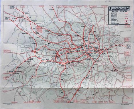
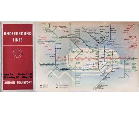
Selection of London Underground MAPS comprising 1919 (2-10-19) in fragile, poor condition, 1924 (3/4/24) ex-guidebook, printed on thin paper, c.1936 ex LPTB annual report, partially stuck to card and a 1982 quad-royal POSTER MAP by Garbutt, laminated and in ex-use condition, quite poor with stains in places. [4]
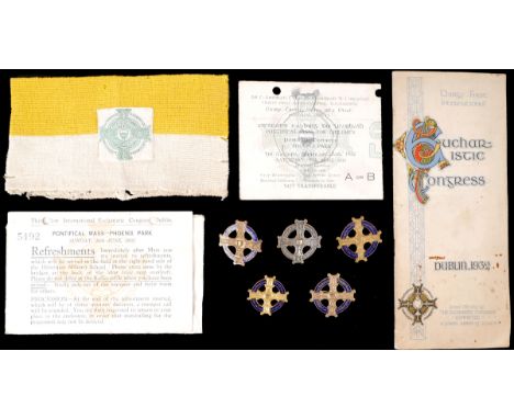
Lot 141
1932 Eucharistic Congress Armband, badges and tickets.Steward's knitted armband in Papal colours with green on white badge attached; a used ticket to the Pontifical Mass for Children, Saturday 25 June; a ticket for refreshments folllowing the Pontifical Mass, Sunday 26th June; a Congress guidebook; together with five gilt metal and enamel Eucharistic Congress badges, of varying sizes and finishes. (9)
Lot 621
Joseph Nash O.W.S. (1809-1878), "Sizergh Castle, Cumbria - The Inlaid Chamber", unsigned, watercolour, 29.5 x 44cm, 11.75 x 17.25in. * This example is illustrated on page 191 and plate number 84 in his ''The Mansions of England in the Olden Time'' (1839-1849) and also on page 24 of The National Trust, Sizergh Castle, 1977 guidebook. For a condition report on this lot visit www.peterwilson.co.uk
Lot 41
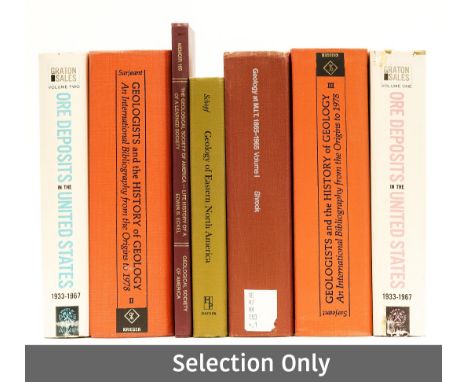
Geology.- America.- Sarjeant (William A. S.) Geologists and the History of Geology, 5 vol., publisher labels to front free endpapers and titles, original cloth, small paper labels to spine foot, Florida, 1980 § Meek (F. B.) A Report on the Invertebrate Cretaceous and Tertiary Fossils of the Upper Missouri Country, illustrations, lithographed plates, abrasion marks to front pastedown, occasional faint spotting, original cloth, a little rubbed, bumping to corners and extremities, cracked joints, Washington, 1876 § Sonnenberg (Frank P.) Billings Geological Society Guidebook, Third Annual Field Conference, plates, illustrations, folding maps to pocket at end, presentation label to front pastedown, original decorative roan, Billings, 1952; and others, similar, v.s. (c.25)
Lot 4
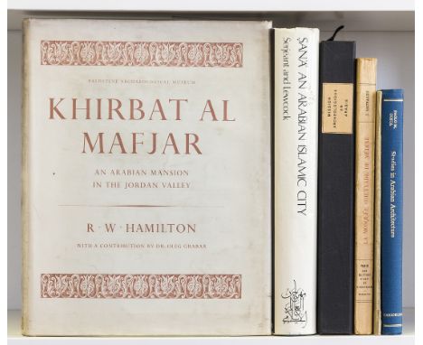
Near East.- Archaeology.- Hamilton (R.W.) Khirbat al Mafjar: an Arabian Mansion in the Jordan Valley, 1956 guidebook to the Umayyad Palace at Khirbat al Mafjar loosely inserted, original buckram, dust-jacket, Oxford, 1959 § Serjeant (R.B.) and Ronald Lewcock, editors. Sana: an Arabian Islamic City, limited edition (unnumbered), original boards, dust-jacket, very slightly frayed at edges, 1983 § Jaussen & Savignac. Mission Archéologie en Arabie III: Les Châteaux Arabes de Qeseir 'Amra, Harâneh et Tûba, 2 vol., text in modern cloth-backed boards with original upper wrapper mounted on upper cover, plates loose as issued, together in modern cloth-backed board folder with velcro fasteners preserving original upper board, rubbed, Paris, 1922, maps, plates and illustrations; and 3 others, Arabian architecture, 4to & 8vo (7)
Lot 52
Terry (T. Philip). Terry's Japanese Empire, including Korea and Formosa. With Chapters on Manchuria, the Trans-Siberian Railway, and the Chief Ocean Routes to Japan. A Guidebook for Travellers, 1st edition, Boston and New York: Houghton Mifflin, 1914, numerous maps and plans, some folding (a few with a couple of short closed tears), advertisements both front and rear, original cloth, 8vo, together with Baedeker (Karl), The United States with Excursions to Mexico, Cuba, Porto Rico, and Alaska. Handbook for Travellers, 4th Revised Edition, Leipzig: Karl Baedeker, 1909, numerous maps and plans, some folding, front free endpaper with top corner excised, original cloth, 8vo, plus Hartleben (A., publisher), Illustrierter Fuhrer durch Dalmatien... langs der Kuste von Albanien bis Korfu..., Vienna and Leipzig: A. Hartleben, 1909, numerous maps and plans, some folding, lacking front free endpaper, original cloth, slightly rubbed, small stain to front cover, 8vo, with 13 other Baedeker guides, including: Egypt and the Sudan, 1914, with dust jacket; Northern Germany, 1925, with dust jacket; and other European such as Spanien und Portugal, Switzerland, Schweden und Norwegen, various editions, and one other related (17)
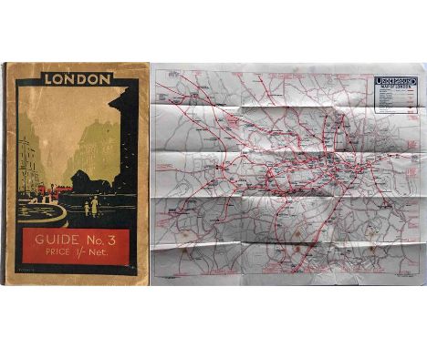
Lot 102
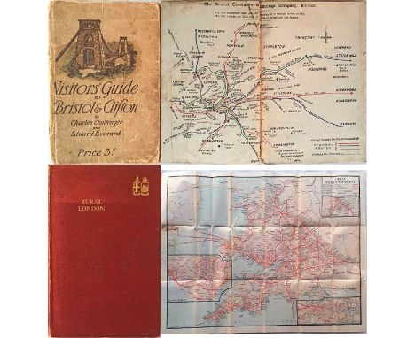
c1910 Visitor's GUIDE to Bristol & Clifton with coloured map of Bristol Tramways and many photos, incl cars & charabancs (heavily used and a little fragile) plus 1924 Great Western Railway GUIDEBOOK 'Rural London' with two fold-out maps of the GWR local services and their full network (lightly-used, good condition). [2]
Lot 171A
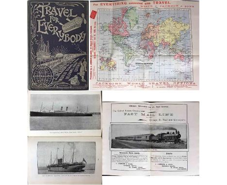
c1902 Jackson & Sons of Liverpool 'World Travel Agency' GUIDEBOOK 'Travel for Everybody'. 186pp inside hard covers with silver titling. Contains a huge amount of information about tours all over the world by ship, train etc, with illustrations, advertisements and fold-out maps of the world and of London. A fascinating, historical record. In very good condition. [1]
Lot 185
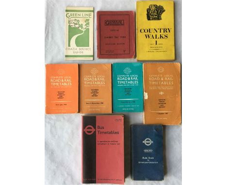
London Transport & predecessor items comprising 1931 Green Line COACH SERVICE GUIDE (27-4-31) (Small stains, generally good), 1932 General Country Services TIMETABLE, Southern Section, Spring Service, 10 April 1932 (good condition), 1936 Country Walks GUIDEBOOK, 4 x 1960s local TIMETABLES (used), March 1977 Inspectors' 'Red Book' TIMETABLE (very good condition) and 1950 (repr 1954) Central Buses Drivers' & Conductors' RULE BOOK (well used, pictures still present). [9]
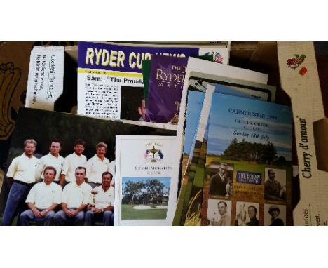
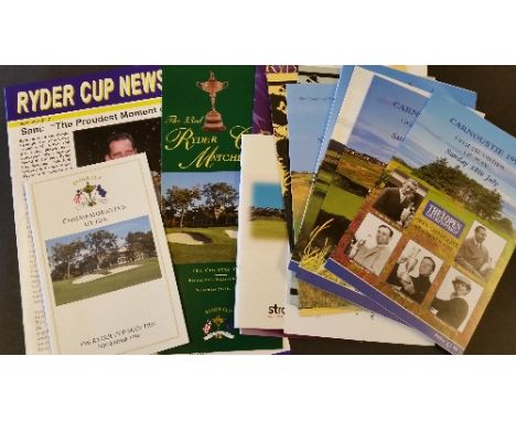
Lot 52
GOLF, selection, inc. Ryder Cup, 2002 programmes (2, one with Ryder Cup News insert), 1999 guidebook, 2004 scorecard (unused); hardback edition of The Open 1960-1990, LE.55/100 (signed by the author Michael Hobbs), with slipcase; The Open Orders of Play (9), 1971 (2), 1999 (3), 2000 (4); press photos (11), mainly at the Open (action & with Claret Jug), VG to EX, 32*
Lot 121
1939 London Underground diagrammatic, card POCKET MAP designed by Hans Schleger (aka 'Zero') who produced a short series from 1938-41 before responsibility was handed back to Beck. This is issue No 1, 1939 and is good condition with a trace of adhesive/stain on the spine where it was once tipped into a guidebook. [1]
Lot 139
1924 London Underground GUIDEBOOK 'London Guide No 3' containing a separate (enclosed in a fixed envelope) UNDERGROUND MAP believed to have been unique to these guides. Printed on thin paper and opening out to 17.5" x 14" (45cm x 36cm), the map is single-coloured and shows the British Empire Exhibition and the Charing Cross link and Morden extensions as under construction. In good, used condition, small stains on the map. [1]
Lot 15
1911 London Underground POCKET MAP printed by Johnson, Riddle & Co Ltd. This edition shows the 3 separate Hammersmith stations, the CLR extension to Liverpool St under construction and the LBSCR lines to Crystal Palace. Ex-guidebook example with the usual small cut-out at the margin and subsequently re-folded. Opens out to 10.5" x 8" (27cm x 20cm). In good, lightly-used condition. [1]
Lot 274
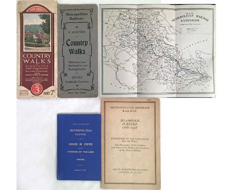
Metropolitan Railway items comprising 1905 'Country Walks' GUIDEBOOK 'The Harrow & Uxbridge Railway...is now open' (incl fold-out map of the Met Rlwy Extension), c1929 Met & LNER 'Country Walks' GUIDEBOOK No 3 and 1927 hard-cover BOOKLET 'Record of Events from the Opening of the Line in 1863, revised to 1927". Plus 1928 Metropolitan District Rlwy BOOKLET 'Diamond Jubilee, Exhibition of Rolling Stock...South Kensington Station". Condition varies from well-used to excellent. [4]
Lot 326
1911 London Underground POCKET MAP printed by Johnson, Riddle & Co Ltd. This edition shows the 3 separate Hammersmith stations, the CLR extension to Liverpool St under construction and the LBSCR lines to Crystal Palace. Opens out to 10.5" x 8" (27cm x 20cm). In very good, lightly-used condition, just a tiny tear at one edge. An ex-guidebook copy, folded accordingly, with a trace of adhesive at one edge. [1]
Lot 351
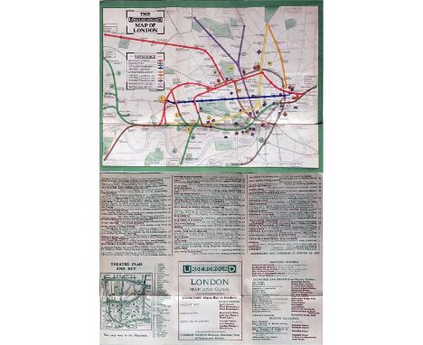
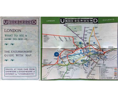
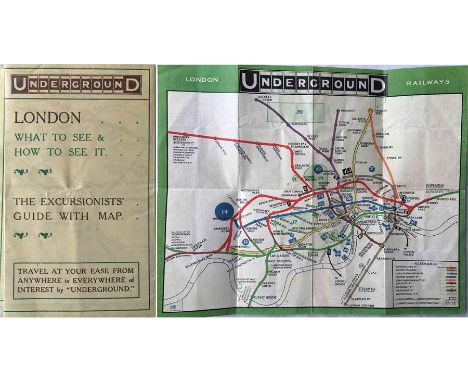
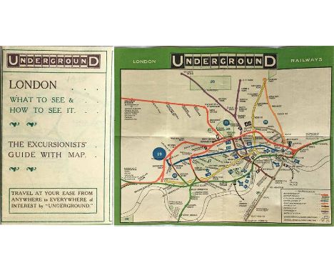
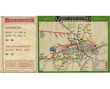
1909 London Underground POCKET MAP 'What to See and How to See it, The Excursionists' Guide with Map'. This is the map with numbers referring to points of interest listed on the reverse. Opens out to 10.5" x 8.5" (27cm x 22cm). Ex-guidebook copy, subsequently re-folded, otherwise in excellent condition. [1]
Lot 387
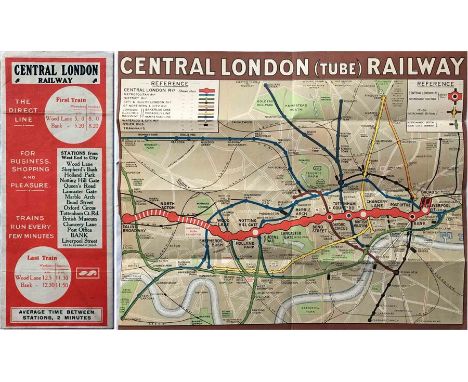
1912 Central London Railway POCKET MAP titled 'Central London (Tube) Railway' with a brown border and in a very similar style to maps produced by the Underground Group (who took over the CLR the following year) but with considerable prominence given to its own line. The Ealing Broadway extension, not yet open, is shown in hatched form and that to Liverpool Street shown as operational. In very good, lightly-used condition, ex-guidebook copy with cut-out at margin and re-folded. [1]
Lot 57
Quantity of London Transport EPHEMERA incl PRESS RELEASES (1960s-1980s), 1950s INTERNAL REPORTS on accidents, delays, experimental features etc, 1920s GUIDEBOOK 'London's Country', 1930s-1990s LEAFLETS, UNDERGROUND TIMETABLE BOOKLETS, POCKET MAPS plus a quantity (70) of Pamlin Prints PHOTO POSTCARDS. In good to very good condition. [Quantity]
![Rock Climbing [Unsworth (Walt)], A Guide to Pontesford Rocks, nd., mounted typescript pages, hand drawn routes and mounted ph](https://cdn.globalauctionplatform.com/f11a2285-4e5a-42f2-bef4-a80200a65809/c0d2f62c-56d3-49b1-a51f-968eb0dc76a7/468x382.jpg)
Lot 151
Rock Climbing [Unsworth (Walt)], A Guide to Pontesford Rocks, nd., mounted typescript pages, hand drawn routes and mounted photograph, with manuscript inscription; 'This is the Original Pontesford Guidebook later modified & published by Wilding's of Shrewsbury, Walt Unsworth', quarter style cloth; Larden (Walter), Guide to the Walks & Climbs around Arolla .., printed in the Year 1908, from MS. Guides made Earlier, original cloth; Nicol (Dave) edit., Rock Climbs in Yosemite, nd (c1974), Keswick, foolscap, plastic spined wraps; with a quantity of other climbing guides (qty)
Lot 249
1939 London Underground diagrammatic, card POCKET MAP designed by Hans Schleger (aka 'Zero') who produced a short series from 1938-41 before responsibility was handed back to Beck. This is issue No 1, 1939 and is a superb example in excellent condition, near-mint, just a very slight trace of adhesive on the spine where it was once tipped into a guidebook. Tiny spots on the cover appear to be from the original printing process. [1]
Lot 6
1909 London Underground POCKET MAP 'What to See and How to See it, The Excursionists' Guide with Map'. This is the map with numbers referring to points of interest listed on the reverse. Slight signs of re-folding, so may be an ex-guidebook copy. Apart from that light creasing, in very good condition. [1]
Lot 17
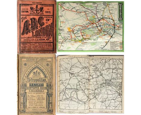
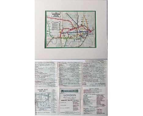
1912 ABC GUIDE TO LONDON containing the official Underground MAP for that year and a fold-out pictorial MAP OF LONDON in 1912. The guidebook shows some wear & ageing but the maps are in very good condition. Plus the 1880 Metropolitan Railway ILLUSTRATED GUIDE with integral map of London showing railways. Worn at spine but otherwise very good. [2]
Lot 369
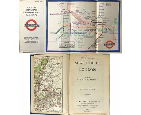
1933 1st edition of the Beck London Underground diagrammatic CARD POCKET MAP tipped into Muirhead's hardback GUIDEBOOK 'Short Guide to London'. The map bears the now famous remark on the cover 'A new design for an old map...'. The map is in excellent condition and the guidebook itself is very good. [1]
Lot 144
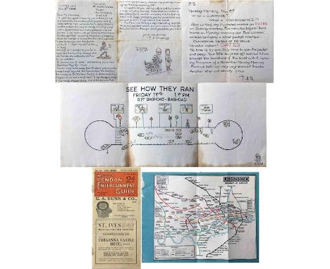
Items relating to F H Stingemore, designer of the pre-Beck Underground maps & erstwhile LT employee, comprising his ILLUSTRATED LETTER (2 parts) dated Nov 1951 making reference to the General Election result with a picture of Clement Attlee being wheeled off as a Bonfire Night guy. With the letter is a humorous ILLUSTRATION 'See How They Ran' in Baghdad. Plus a 1929 GUIDEBOOK with a paper Stingemore UNDERGROUND MAP tipped in. Items have some wear & ageing. [3]
Lot 189
1909 London Underground POCKET MAP 'What to See and How to See it, The Excursionists' Guide with Map'. This is the map with numbers referring to points of interest listed on the reverse. Note that this is a genuine pocket-map, folded accordingly, NOT one of the ex-guidebook examples. In excellent condition, crisp and firm with barely a blemish. [1]
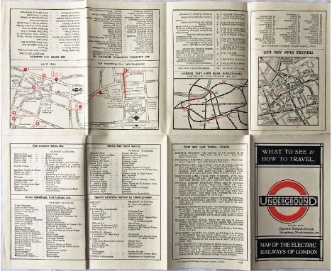
Lot 231
1922 London Underground MAP OF THE ELECTRIC RAILWAYS OF LONDON 'What to See & How to Travel' with issue date 1-3-22. Designed by MacDonald Gill with calligraphed station names, the map opens out to 13.5" x 11" (34 x 28cm). A very good copy with a very slight trace of adhesive on the spine where it was once tipped into a guidebook and a very small parting at one fold-corner but otherwise excellent. [1]
Lot 23
1911 London Underground POCKET MAP loose-mounted in a thick-card frame for display (taped in position at one point on reverse). This edition shows the 3 separate Hammersmith stations, the CLR extension to Liverpool St under construction and the LBSCR lines to Crystal Palace. An ex-guidebook issue in very good condition. Measures 15" x 12" (38cm x 31cm) with frame. [1]
Lot 293
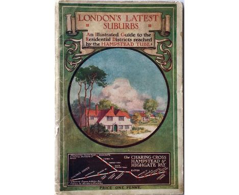
1910 GUIDEBOOK issued by the Charing Cross, Hampstead & Highgate Railway entitled "London's Latest Suburbs - an illustrated Guide to the Residential Districts reached by the Hampstead Tube". 108pp with a colourful illustration and map of the line on the cover. A most unusual item. Some age-staining and wear to the covers but generally in very good condition. [1]
Lot 286
1909 London Underground POCKET MAP 'What to See and How to See it, The Excursionists' Guide with Map'. This is the map with numbers referring to points of interest listed on the reverse. Note that this is a genuine pocket-map, folded accordingly, NOT one of the ex-guidebook examples. A few creases but generally in very good condition. [1]
Lot 404
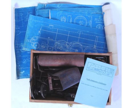
An original vintage ' Princess Royal ' 2.5" gauge locomotive live steam kit. Believed to be complete (but is sold strictly as unchecked), the loco appears part-made, with many bogies and lower chassis components appearing part made / started. Various other bits included. Comes with the correct guidebook, and a number of associated blueprint plants. Some drawings appear to be from the actual Princess Royal, obtained by the builder from the originals. Unusual, rare. From the same collection as lot 85
Lot 686A
R T MCMULLEN: DOWN CHANNEL FROM LONDON TO THE LANDS END IN THE "LEO"..., London, 1869, 1st edition, frontis + 4 maps (of which 2 folding), original blind stamped cloth gilt worn, + SUMMER TOURS IN SCOTLAND, GLASGOW TO THE HIGHLANDS, THE ROYAL ROUTE WITH TIMETABLES AND LIST OF FARES, WITH DAVID MACBRAYNE'S ROYAL MAIL STEAMERS "COLUMBA", "IONA" ETC, 1896, "Official Guide - new edition", original pictorial cloth gilt worn + LT COL F M BAILEY: CHINA - TIBET - ASSAM, A JOURNEY, 1911, 1945 1st edition, original cloth gilt + S M BURROWS: THE BURIED CITIES OF CEYLON; A GUIDEBOOK TO ANURADHAPURA AND POLLONARUA; WITH CHAPTERS ON DAMBULLA, KALAWEWA..., Columbo, A M & J Ferguson, 1885, folding map + folding railway timetable, original half cloth worn and soiled, + R P MURRAY: THE FLORA OF SOMERSET, Taunton, 1896, rebound half calf gilt, top edge gilt + FISHERS DRAWING ROOM SCRAPBOOK WITH POETICAL ILLUSTRATIONS, London, 1833, grey frontis, engraved vignette title + 34 engraved plates as called for, original calf backed blind stamped cloth gilt, all edges gilt, inner joints split (6)
Lot 188
1909 London Underground POCKET MAP 'What to See and How to See it, The Excursionists' Guide with Map'. This is the map with numbers referring to points of interest listed on the reverse. Ex-guidebook example with the usual printer's cut-out at the bottom r/h edge and folded accordingly. A trace of adhesive on the reverse edge where once attached to the guidebook but otherwise in good condition. [1]
Lot 449
Lassels (Richard). The Voyage of Italy, or a Compleat Journey through Italy..., 2 parts in 1 volume, 1st edition, 1st impression, Paris [London], 1670, lacks additional engraved title, blank at end of part 1 and both blanks at end of part 2, Downside Abbey inkstamp to first title and stamped number upper right, contemporary panelled calf with Signet Library gilt stamp to both covers, neatly rebacked, 12mo First issue with Starkey imprint on general title. Considered the most influential English guidebook of the period, this work paid great attention to art and architecture and so helping foster the phenomenon of the eighteenth-century 'Grand Tour', a term coined by Lassels. Wing L465. (1)
Lot 23
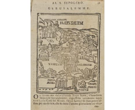
Noe (Bianco). Viaggio da Venezia al S. Sepolcro e al Monte Sinai col disegno delle Citta, Castelli, Ville, Chiese, Monasteri, Isole, Porti, e Fiumi, che fin la si ritrovano, Lucca, Domenico Marescandoli, circa 1690, 192 pp., title with woodcut vignette, numerous woodcut illustrations, some soiling and water stains, one or two closed tears, contemporary limp vellum, worn, 8vo Early guidebook for pilgrims visiting the Holy Land, including views of Jerusalem and the Temple of Solomon, as well as lists of relics in Venetian churches. Seems to correspond with the copies held at Oxford and at the British Library, Oxford dating this edition between 1666 and 1699, the British Library copy, circa 1700. (1)
Lot 124
1909 London Underground POCKET MAP -'What to see & how to see it - The Excursionist's Guide with Map'. This was the first issue to dispense with the streets background, resulting in a much clearer image, and also one of the first to use the famous UndergrounD logo. It was aimed at the leisure market with numbers referring to listed places of interest. Ex-guidebook copy in good condition with adhesive trace at one edge and alternative folding. [1]
Lot 144
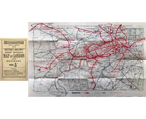
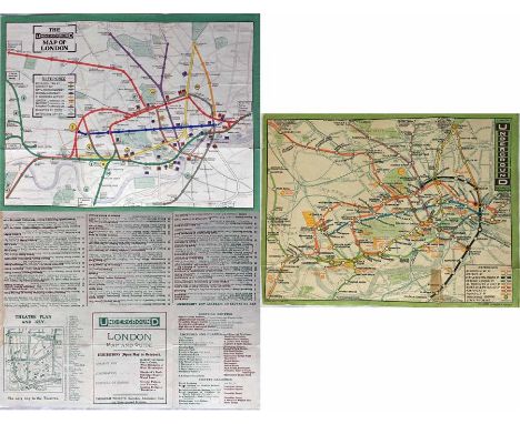
The District Railway POCKET REFERENCE MAP OF LONDON. Undated but c1906. Opens out to the District Railway Miniature Map of London and Environs, 7th edition 17.5" x 11" (45cm x 28cm). The reverse has places of amusement, train times etc. Most examples of these maps are found as guidebook copies and it is most unusual to come across a surviving pocket version (price 1/2d). Includes the early tube lines. Lightly used with some wear but still very presentable. [1]
Lot 278
1911 London Underground POCKET MAP. Printed by Johnson, Riddle & Co Ltd, interesting features are the 3 stations at Hammersmith and the inclusion of the LBSCR lines to Crystal Palace. Places of interest and theatre map on the reverse. In well-used condition with wear at some folds, small corner-partings and pencilled annotations on reverse but still very reasonable. Ex-guidebook copy, has been re-folded. [1]
-
301 item(s)/page