Lot 528
A large quantity of contemporary Ordnance Survey maps of Great Britain, largely Cumbria / Lake
A large quantity of contemporary Ordnance Survey maps of Great Britain, largely Cumbria / Lake District
A large quantity of contemporary Ordnance Survey maps of Great Britain, largely Cumbria / Lake District
A group of late 19th Century and other maps of Great Britain, including cloth-backed examples published by the Ordnance Survey Office, John Bartho...
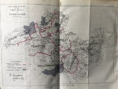
Title: Antique 139 Years-Old Scarce Map South West Riding Yorkshire 1885Description: Zincographed Ordnance Survey Map Produced by Colonel R. ...
Title: Antique 139 Years-Old Scarce Map County of Devon 1885 Boundary Changes.Description: Antique 139 Years-Old Scarce Map County of Devon 1...
Title: Antique 139 Years-Old Scarce Map County Essex 1885 Boundary Changes.Description: Antique 139 Years-Old Scarce Map County Essex 1885 Bo...
Title: Antique 139 Years-Old Scarce Map Stoke On Trent 1885 Boundary Changes.Description: Antique 139 Years-Old Scarce Map Stoke On Trent 188...
Title: Antique 139 Years-Old Scarce Map Lincolnshire 1885 Boundary Changes.Description: Antique 139 Years-Old Scarce Map Lincolnshire 1885 Bo...
Title: Antique 139 Years-Old Scarce Map City of Bradford 1885 Boundary Changes.Description: Antique 139 Years-Old Scarce Map City of Bradford...
Title: Antique 139 Years-Old Scarce Map South West Riding Yorkshire 1885 Boundary Changes.Description: Zincographed Ordnance Survey Map Produ...
Title: Antique 139 Years-Old Scarce Map North West Riding Yorkshire 1885 Boundary ChangeDescription: Zincographed Ordnance Survey Map Produce...
Title: Antique 139 Years-Old Scarce Map County of Middlesex & London 1885 Boundary Changes.Description: Antique 139 Years-Old Scarce Map Coun...
Title: Antique 139 Years-Old Scarce Map City of Reading 1885 Boundary Changes.Description: Antique 139 Years-Old Scarce Map City of Reading 1...
Title: Antique 139 Years-Old Scarce Map of Bedfordshire Boundary Changes 1885.Description: Antique 139 Years-Old Scarce Map of Bedfordshire ...
Title: Antique 139 Years-Old Scarce Coloured Map Lake District 1885 Boundary Changes.Description: Antique 139 Years-Old Scarce Map Lake Distr...
Title: Antique 139 Years-Old Scarce Map Lake District Cumbria 1885 Boundary Changes.Description: Antique 139 Years-Old Scarce Map Cumbria 188...
Title: Antique 139 Years-Old Scarce Map Buckinghamshire 1885 Boundary Changes.Description: Antique 139 Years-Old Scarce Map Buckinghamshire 1...
Title: Antique 139 Years-Old Scarce Map Denbighshire 1885 Boundary Changes.Description: Antique 139 Years-Old Scarce Map Denbighshire 1885 Bo...
Title: Antique 139 Years-Old Scarce Map Carmarthenshire 1885 Boundary Changes.Description: Antique 139 Years-Old Scarce Map Carmarthenshire 1...
Title: Antique 139 Years-Old Scarce Map Northamptonshire 1885 Boundary Changes.Description: Antique 139 Years-Old Scarce Map Northamptonshire...
Title: Antique 139 Years-Old Scarce Map Cheltenham 1885 Boundary Changes.Description: Antique 139 Years-Old Scarce Map Cheltenham 1885 Bounda...
Quantity of various One-Inch & Ordnance Survey maps - various places in the UK ALL USED UNCHECKED
A selection of Ordnance Survey maps
A large quantity of early 20th century Ordnance Survey maps, to include Carmarthen, St. David's & Cardigan, Brecon & Llandovery, Abergavenny, Glou...
Two boxes containing various vintage Ordnance Survey maps, to include Loch Lomond, Bradford, Bolton ect, over 100
A group of 7 blue binders holding various ordnance survey maps of Great Britain, (7)
Two boxes containing various Ordnance Survey maps of the UK, to include Preston and Blackpool, Askrigg & Settle and Selkirk, over 100 maps
A large vintage framed Ordnance Survey map depicting the Chilterns, the map dated 1932 lower right, in ebonised frame, 85cm x 79cm
A large qty of assorted maps, mainly Ordnance Survey
SIX BOXES OF MAPS AND BOOKS, to include over one hundred Ordnance Survey Land ranger Maps, travel guides, English Heritage and National Trust guid...
A large collection of Ordnance Survey maps, Landranger, Explorer and others (50+)
Large quantity of 1940s-1960s Ordnance Survey maps (150+) mostly one-inch maps
COLLECTION OF WWII AVIATION MAPS, comprising of a number of aviation and military related maps, mainly comprising Ordnance Survey Aeronautical map...
A PAIR OF ORDNANCE SURVEY BLACK AND WHITE MAPS OF LONDON Numbered TQ2477 and TQ2577 and TQ2476 and TQ 2577, framed and glazed. (approx 86cm x 60cm...
Folding Maps. Four titles: Bacon's New Commercial & Reference Chart of the British Isles (c.1910); Ordnance Survey Map of Roman Britain; Ordnance ...
Great Britain OHMS envelope cancelled with Southampton Machine Slogan cancel posted to O.C. Air HQ RAF Habbaniya Iraq. Oval military Admin Ordnanc...