

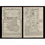
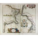
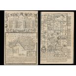
London. Lewis, (Samuel) A plan of London and its Environs shewing the Boundaries, shewing the Boundaries of the Cities of London and Westminster, ...
shoe
Receive email alerts when new lots matching "shoe" come up for sale.
72 item(s)
Filtered by:
- Category
- List
- Grid
-
72 item(s)/page
Lot 921
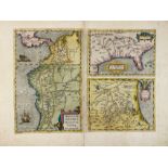
AMERICA -- "PERUVIAE AURIFERAE Regionis Typus". - On sheet with: "LA FLORIDA". - And: "GUASTECAN
AMERICA -- "PERUVIAE AURIFERAE Regionis Typus". - On sheet with: "LA FLORIDA". - And: "GUASTECAN Reg." - (Antw., A. Ortelius, C. 1588). Handcold. ...

Lot 63
Qty 1880's maps of area's to South End of Wisbech showing land division and 2 antique Atlas' 1906
Qty 1880's maps of area's to South End of Wisbech showing land division and 2 antique Atlas' 1906 and 1922

An 1831 hand coloured map of Helston showing the boundaries of the Old Borough after R. K. Dunstan, framed and glazed
Lot 922
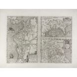
AMERICA -- "PERUVIAE AURIFERAE Regionis Typus". - On sheet with: "LA FLORIDA". - And: "GUASTECAN
AMERICA -- "PERUVIAE AURIFERAE Regionis Typus". - On sheet with: "LA FLORIDA". - And: "GUASTECAN Reg." - (Antw., A. Ortelius, C. 1588). Plain engr...

Lot 409
TWO PRINTS AND TWO MAPS (4). To include one by Valerie Thornton (sheet size 37cm x 27cm) Prints
TWO PRINTS AND TWO MAPS (4). To include one by Valerie Thornton (sheet size 37cm x 27cm) Prints are framed and glazed, maps are glazed.

Lot 203
A map of Surrey, mid-20th century, showing 5-mile radii of Banstead within a quadruple outlined b...
A map of Surrey, mid-20th century, showing 5-mile radii of Banstead within a quadruple outlined border, hand-painted scroll title to top left corn...

Lot 2120
Maps: A 20thC Map of England and Wales on two folding cloth sheets North Sheet and South Sheet, with
Maps: A 20thC Map of England and Wales on two folding cloth sheets North Sheet and South Sheet, with Index Guide to Map. Published by The Chart Pu...

Lot 71
An antique map showing the 'British Islands in the West Indies' engraved by J. & C. Walker, 13" x
An antique map showing the 'British Islands in the West Indies' engraved by J. & C. Walker, 13" x 15.75" (33 x 40cm).

Lot 321
James Fittler (English 1758-1835). View of the town of Newcastle upon Tyne, taken from the Shield-fi
James Fittler (English 1758-1835). View of the town of Newcastle upon Tyne, taken from the Shield-field and dedicated to Hugh, Duke and Earl of No...
Title: Bowen 290 Yrs Old Detailed Road Map Hereford, Ludlow, Shrewsbury. Description: Bowen 290 Yrs Old Detailed Road Map Hereford,...

Lot 503
An Ordnance Survey Map, Sheet SD37, illustrating Cartmel Sands and surrounding area, scale 1:25,000,
An Ordnance Survey Map, Sheet SD37, illustrating Cartmel Sands and surrounding area, scale 1:25,000, framed and under glass, measuring 45cm x 55cm...

Lot 21
20th Century English School. "Map of London" edition of 1920, Sheet K, Map, Published by Ordnance
20th Century English School. "Map of London" edition of 1920, Sheet K, Map, Published by Ordnance Survey Office, unframed, 24" x 36" (61 x 91.5cm)
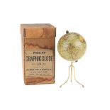
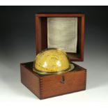
A Good Philips 4in Terrestrial Globe, English, c.1870 (as the globe shows the Sandwich islands and 'the dominion of Canada' indicating an age of c...
Title: Bowen 290 Yrs Old Detailed Road Map Whitby to Durham Newcastle North East. Description: Bowen 290 Yrs Old Detailed Road Map ...
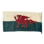
EARLY WELSH FLAG (Y DDRAIG GOCH), circa 1960s, printed cotton with stitched edge and 'British Made' in the print, 43 x 88cms, affixed to short bam...

Lot 276
A 19th century hand coloured Cornish mining print "Digging for Tin Under the Sea in Cornwall" after
A 19th century hand coloured Cornish mining print "Digging for Tin Under the Sea in Cornwall" after Harold Oakley, the footnote details "This Diag...

Lot 41
Ordnance Survey of Scotland:
Ordnance Survey of Scotland: Complete set. 92 colour maps , each dissected into 4 sections laid on linen, with numbering tabs, preserved in...
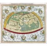
WORLD MAP -- "PTOLEMEISCH GENERAL TAFEL / die halbe Kugel der Welt begreiffende". (Basel, c. 1590). Handcold. woodcut double-page map from S. Muns...

Lot 58
Pine (John):
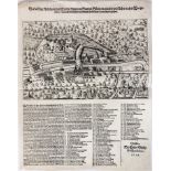
Pine (John): Two untitled charts showing the progress of the Spanish Armada (nos. 9 & 10), 1739. Two hand-coloured charts on one sheet (as pub...
Lot 918
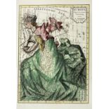
ALLEGORICAL MAP -- (EUROPA REGINA, Queen Europe). (Basel, H. Petri, 1588). Plain allegorical
ALLEGORICAL MAP -- (EUROPA REGINA, Queen Europe). (Basel, H. Petri, 1588). Plain allegorical woodcut map from S. Munster's 'Cosmographey', German ...

Lot 339
DEVON. Speed, John.
DEVON. Speed, John. Devonshire with Excester Described, an engraved county map, hand coloured, to be sold by Bassett & Chiswell (1676 edn.), in a ...

Ordnance Survey of England and Wales: Complete set of the 7th Series. 190 one-inch colour maps , each dissected into 6 sections laid on li...
ALLEGORICAL MAP -- "EUROPA Volgens de nieuwste Verdeeling". Haarlem, F. Bohn, (1794). Cont. handcold. allegorical engr. map. 237 x 167 mm. (Left b...

Lot 12
SCOTLAND (4 Maps):
SCOTLAND (4 Maps): Collins, Captain Greenvile: The East Coast of Scotland with the Isles of Orkney and Shetland . c.1693, hand-coloured and mou...

Lot 517
SIX BOXES OF BOOKS AND EPHEMERA, to include a school exercise book belonging to a George Picker, who
SIX BOXES OF BOOKS AND EPHEMERA, to include a school exercise book belonging to a George Picker, who went to Leadenham School, dated October 26th ...

Lot 363
SPEED, John.
SPEED, John. Devonshire with Excester Described, published by John Sudbury & George Humble 1623, hand coloured map, Exeter shown in an inset to on...

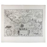
CASPIAN SEA -- "NIEUWE CAART van de Caspische Zee, met alle desselfs riviere, eylanden en dieptens; na de laatste observatien gelegt en verbeeterd...
ITALY -- "WARHAFFTIGE ABBILDUNG deß Flecken Plurs, in Grawen Bündten gelegen : wie solcher noch in Flor gewesen, Und auch, wie solcher nach seinem...
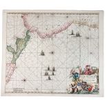
SEA CHARTS -- "NOVÆ HISPANIÆ, Chili, Peruviæ, et Guatimalæ Littoræ". (Amst.), F. de Wit, (c. 1688). Handcold. engr. chart. w. beautiful cartouche ...
SOUTH AMERICA -- PERU -- "CARTA PARTICOLARE del'Peru che comincia con il capo di Guanapo e finisce con il C:S: Francesco". (Florence, 1646). Plain...
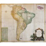
SOUTH AMERICA -- "A MAP OF SOUTH AMERICA containing Tierra Firma, Guyana, New Granada, Amazonia, Brasil, Peru, Paraguay, Chaco, Tucuman, Chili and...

Lot 34
SPEED, John:
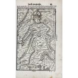
SPEED, John: SHROPSHYRE DESCRIBED Shropshire. c.1649, hand-coloured. 51 x 38cm : Shrowesbury Described the sittuation of Shrowesbury Shewed, ...

Stereoviews Scenes in Scandinavia Collection of stereoviews mounted on card showing scenes mainly in Scandinavia. Other views include the UK and E...

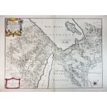
Title: Palestine the Holy Land The Dead Sea, Damascus, Galilee Coloured Antique Map Description: Palestine the Holy Land The Dead Sea,...

SOUTH AMERICA -- PERU -- "LE PEROU dans l'Amerique meridionale, dressé sur les divers relations des flibustiers et nouveaux voyageurs". Par., I.F....
AFRICA -- "GUINEAE NOVA DESCRIPTIO". (Amst., Mercator/Hondius, c. 1638). Plain engr. map w. 2 cartouches and 2 ships. 342 x 480 mm. -- "AETHIOPIA ...
SOUTH AMERICA -- MEXICO -- "LE VIEUX MEXIQUE ou Nouvelle Espagne avec les costes de la Floride". (Paris), N. de Fer, 1705. Handcold. engr. map. 23...
EGYPT -- "LES DESERTS D'EGYPTE, de Thebaide d'Arabie, de Sirie, &c (…)". Par., E. Michalet, 1693. Engr. map, partly handcold., showing Egypt and t...
RUSSIA -- "NOVA ET ACCURATA Wolgæ fluminis, olim Rha dicit delineatio". (Lond.), Janssonius-Waesbergius & M. Pitt, (c. 1680). Handcold. engr. map....
Lot 702
Seltener Marine Himmelsglobus
Seltener Marine Himmelsglobus aus Kapitänsnachlass. London, 1920, bezeichnet "The Husun Star Globe, H. Hughes & Son LTD, London, 1920", der Globu...

Lot 331
AFRICA. ANON.
AFRICA. ANON. an engraved plate from an 18th century publication showing a prospect view of Cape Town, a plan of the castle and a view of Table Ba...

Railwayana. Walker's A New Map of England & Wales with part of Scotland showing the Mail Coach, Turnpike & Railroads, Canals & C. a steel engrave...

MAPS: 1- (HOLY LAND.) Wells, Edward, A New Map Shewing the Travels of the Patriarchs... c.1720, hand-coloured, mounted, framed and glazed ; 2- ...

divided into provinces, counties and baronies. Southern section. Showing the archbishoprics, bishoprics, cities, boroughs, market towns, villages,...

Title: Antique Palestine Religious Map of Holy Land As Allotted By Joshua. Description: Antique Palestine Religious Map of Holy Land A...
Lot 932
CASPIAN SEA -- "GEOGRAPHICA NOVA ex Oriente (…) quarum una Mare Caspium, altera Kamtzadaliam
CASPIAN SEA -- "GEOGRAPHICA NOVA ex Oriente (…) quarum una Mare Caspium, altera Kamtzadaliam seu Terram Jedso curiose exhibet". Nürnberg, J.B. Hom...
LOW COUNTRIES -- DELFT -- "AFBEELDING der Stad Delft" (also called: "Kaart figuratief van Delft"). Amst., P. Smith, n.d. (1703). Engr. wall plan o...

Lot 417
C B GLOT: Uncoloured 18th Century engraved map of Geneva (1777): 'Plan de la Ville de Geneve Corrige
C B GLOT: Uncoloured 18th Century engraved map of Geneva (1777): 'Plan de la Ville de Geneve Corrige sur les lieux, en 1777, et 93 Dedie aux Magni...

SANTINI, Paolo. Nouvelle Carte De L'Etat De L'Eglise, Dressée sur Celle Du P. Boscovich, engraved map of Rome and district, title contained within...

A GEORGE III NEEDLEWORK MAP SAMPLER, WORKED BY SUSANNAH POYNDER, 1788 oval, embroidered linen 'MAP OF ENGLAND & WALES' delineating the named cou...

Lot 1667
Vintage advertising poster for 'R.A. Wright & Co Ltd, bottlers of ales, stout and mineral waters...
Vintage advertising poster for 'R.A. Wright & Co Ltd, bottlers of ales, stout and mineral waters...Cumberland St, York', printed by Woollen & Co, ...

Title: Bowen 290 Yrs Old Detailed Road Map London Bedford Biggleswade Ampthill. Description: Bowen 290 Yrs Old Detailed Road Map Lo...
Title: Emanuel Bowen 290 Yrs Old Detailed Road Map London To St Davids Wales. Description: Bowen 290 Yrs Old Detailed Road Map Lond...

Title: Emanuel Bowen 290 Yrs Old Detailed Road Map London To Yarmouth. Description: Bowen 290 Yrs Old Detailed Road Map London To ...

Title: Collection 15 WW1 Harmsworth Atlas Antique Map 1922. Description: Collection 15 WW1 Harmsworth Atlas Antique Map 1922. Thi...
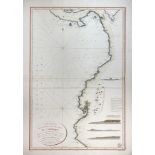
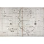
SEA CHARTS -- DÉPOT GÉNÉRALE DE LA MARINE -- "CARTE RÉDUITE de la côte occidentale de l'Amérique". 1821. Handcold. engr. chart. 930 x 620 mm. (Som...
SOUTH AMERICA -- PANAMA -- "DESCRIPTION DE L'ISTHME de Darien, des proprietez du pais et de la ville de Panama (…)". (Amst., 1719). Engr. plain sh...

SOUTH AMERICA -- PERU -- "CARTE DU PEROU ou se trouvent les Audiences de Quito, Lima et la Plata". Par., (1772). Engr. map, cold. in outlines, by ...
SOUTH AMERICA -- ECUADOR -- "CARTE DE LA MERIDIENE mesurée Royaume de Quito . p. J. Juan & A. de Ulloa en 1744. Engr. map on 3 sheets. 230 x 1000 ...