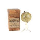

A Good Philips 4in Terrestrial Globe, English, c.1870 (as the globe shows the Sandwich islands and 'the dominion of Canada' indicating an age of c...
517 item(s)
Filtered by:
- Category,
- Country
- List
- Grid
-
517 item(s)/page
Lot 660
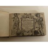
Speed, John 1627 England, Wales, Scotland and Ireland with fronttispiece, distance tables and 63
Speed, John 1627 England, Wales, Scotland and Ireland with fronttispiece, distance tables and 63 maps - has a tear to page on Caernavonshire - a v...
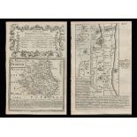
Title: Bowen 290 Yrs Old Detailed Road Map Whitby to Durham Newcastle North East. Description: Bowen 290 Yrs Old Detailed Road Map ...
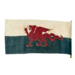
EARLY WELSH FLAG (Y DDRAIG GOCH), circa 1960s, printed cotton with stitched edge and 'British Made' in the print, 43 x 88cms, affixed to short bam...

John Speed 17th century engraved map of Africa, engraved by Abraham Goos, English text verso, plate 40 x 52cm

Lot 846
John Speed 17th century engraved map - Britain as it was Devided in the Tyme of the English Saxons
John Speed 17th century engraved map - Britain as it was Devided in the Tyme of the English Saxons especially during their Heptarchy, sold by Bass...

Lot 1386
TWO LEATHER CASES OF JOHNSTONS THREE MILES TO INCH MAPS, ONE CONTAINING MAPS OF SCOTLAND AND THE
1386TWO LEATHER CASES OF JOHNSTONS THREE MILES TO INCH MAPS, ONE CONTAINING MAPS OF SCOTLAND AND THE
TWO LEATHER CASES OF JOHNSTONS THREE MILES TO INCH MAPS, ONE CONTAINING MAPS OF SCOTLAND AND THE OTHER OF ENGLAND AND WALES


John Speed - 17th century engraved map - The Kingdom of China, sold by Baskett and Chiswell, English text verso, plate 40 x 51cm

Lot 276
A 19th century hand coloured Cornish mining print "Digging for Tin Under the Sea in Cornwall" after
A 19th century hand coloured Cornish mining print "Digging for Tin Under the Sea in Cornwall" after Harold Oakley, the footnote details "This Diag...

Jan Huygen Van & Hendrik Floris Van Langren: LINSCHOTEN, Deliniantur in hac tabula, Orae Maritimae Abexiae, freti Mecani; al Maris Rubri; Ara...

Lot 110B
POCKET GLOBE: A CORRECT POCKET GLOBE WITH NEW INSTALLATIONS BY HALLEY AND CO CIRCA LATE 18TH CENTURY
POCKET GLOBE: A CORRECT POCKET GLOBE WITH NEW INSTALLATIONS BY HALLEY AND CO CIRCA LATE 18TH CENTURY IN A SHAGREEN CASE. Case 8cm D Globe 6.5cm D ...

John Speed - 17th century engraved map of Asia, sold by Baskett and Chiswell, with English text verso, plate 40 x 51cm

Lot 401
A.A. MILNE: THREE FIRST EDITIONS AND ANOTHER LATER EDITION (4), The House at Pooh Corner, first
A.A. MILNE: THREE FIRST EDITIONS AND ANOTHER LATER EDITION (4), The House at Pooh Corner, first published in 1928, Methuen and Co Ltd Winnie th...

John Speed - 17th century engraved map of Europ and the chiefe Cities contayned therin ..., pen inscriptions to the margins, English text verso, p...

John Speed 17th century engraved map of The British Isles, English text verso, plate 41 x 50cm

Lot 525
ROBERT MORDEN: TWO HAND COLOURED ENGRAVED MAPS COMPRISING SOMERSETSHIRE AND GLOUCESTERSHIRE, 42 x
525ROBERT MORDEN: TWO HAND COLOURED ENGRAVED MAPS COMPRISING SOMERSETSHIRE AND GLOUCESTERSHIRE, 42 x
ROBERT MORDEN: TWO HAND COLOURED ENGRAVED MAPS COMPRISING SOMERSETSHIRE AND GLOUCESTERSHIRE, 42 x 36cms and 41.5 x 34cms. (2)

Lot 89
JOHN SPEED coloured 1610 copper engraved map - entitled in cartouche 'Caermarden, Both Shyre and
JOHN SPEED coloured 1610 copper engraved map - entitled in cartouche 'Caermarden, Both Shyre and Town described', with inset plan of Carmarthen to...

Lot 22
Speed, J:
Speed, J: Kent with her cities and Earles described & observed . Bassett & Chiswell (?), c.1616, hand-coloured, mounted, framed and glazed, 37...

John Speed - 17th century engraved Map of America, dated 1626 (but 1676), sold by Baskett and Chiswell, pen inscriptions to margin, English text v...

Lot 41
Ordnance Survey of Scotland:
Ordnance Survey of Scotland: Complete set. 92 colour maps , each dissected into 4 sections laid on linen, with numbering tabs, preserved in...

John Speed 17th century engraved map of The Romane Empire, English text verso, plate 41 x 50cm

A rare collection of WW2 Maps of the Tobruk together with canvas map case

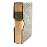
FOLIO SOCIETY, Limited Edition: QUEEN MARY ATLAS. Two Volumes. Folio Society, 2005. Limited Edition No. 581 of 1000 . Folio, Bound in full c...

Lot 58
Pine (John):
Pine (John): Two untitled charts showing the progress of the Spanish Armada (nos. 9 & 10), 1739. Two hand-coloured charts on one sheet (as pub...

Lot 67
MAP OF TURKEY:
MAP OF TURKEY: Ortelius, Abraham: Turcici Imperii Descriptio . London, 1606, English text to rear (A rare English edition, only 300 were printe...

Lot 475
A QUANTITY OF 17TH, 18TH AND 19TH CENTURY WELSH AND ENGLISH MAPS, to include a John Speed map of
A QUANTITY OF 17TH, 18TH AND 19TH CENTURY WELSH AND ENGLISH MAPS, to include a John Speed map of Wales with counties either side circa 1610, John ...

Lot 549
A selection of Indian related engravings and maps including "Plan of the Cantonment of Ootacamund
549A selection of Indian related engravings and maps including "Plan of the Cantonment of Ootacamund
A selection of Indian related engravings and maps including "Plan of the Cantonment of Ootacamund 1841"; pen and ink sketch of a balcony scene; a ...

One packet: Mixed architectural plan and maps of Norfolk interest, to include: Hethersett, Wroxham, Carbrooke, Trunch etc

Lot 412
John Speed (British,1552-1629) Cumberland, handcoloured engraved map, circa 1627, 42x53cm, framed
412John Speed (British,1552-1629) Cumberland, handcoloured engraved map, circa 1627, 42x53cm, framed
John Speed (British,1552-1629) Cumberland, handcoloured engraved map, circa 1627, 42x53cm, framed and glazed.

Lot 339
DEVON. Speed, John.
DEVON. Speed, John. Devonshire with Excester Described, an engraved county map, hand coloured, to be sold by Bassett & Chiswell (1676 edn.), in a ...

London. Fraser's Panoramic Plan of London, London, 1831, James Fraser, a steel engraved folding map dissected in fifteen sections and backed on ...

London. Bowles's Reduced New Pocket Plan of the Cities of London and Westminster, with the Borough of Southwark, exhibiting the New Buildings to 1...

Lot 651
John Speed (1552-1629), a coloured map of Jamaica and Barbados, sold by Thomas Basset in Fleet
John Speed (1552-1629), a coloured map of Jamaica and Barbados, sold by Thomas Basset in Fleet Street, and Richard Chiswell in St Paul's Churchya...

Lot 5
Walker (J & C):
Walker (J & C): A Geological Map of England and Wales. Published by Charles Knight for the SDUK, 1843. Hand-coloured, mounted, framed and gla...

Lot 12
SCOTLAND (4 Maps):
SCOTLAND (4 Maps): Collins, Captain Greenvile: The East Coast of Scotland with the Isles of Orkney and Shetland . c.1693, hand-coloured and mou...

Lot 27
SPEED, John:
SPEED, John: The Isle of Man Exactly described...Described by Tho. Durham Ano. 1595, performed by John Speed Anno 1610. [1676], Bassett & Chis...

Lot 32
Jansson:
Jansson: Comitatis Cantabrigiensis vernacule Cambridgeshire , Amsterdam, c.1650. Hand-coloured, 51 x 41cm ; Middelsexiae, cum Hertfordiae, Comi...

Lot 64
Ortelius, Abraham:
Ortelius, Abraham: Maris Pacifici (quod vulgo Mar del Zur) cum regionibus circumiacentibus, insulisque in eodem passim sparsis, novissima desc...

J Blaeu, hand coloured map of Norfolk, c1650. 38cm x 50cm, framed and glazed.

John Ogilby - rare engraved Map of Carolina, 1672 - "A New Discription of Carolina By Order of the Lords Proprietors" from Ogliby's, America; unc...
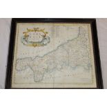
A 17th century hand coloured map of Cornwall by Robert Morden, framed and glazed
Thames. Ravenstein's Oarsmen's and Anglers Map of the River Thames from its source to London Bridge a concertina style folding map backed on line...

London. Mogg's Stranger's Guide Through London and entirely New Plan. .....' steel engraved dissected folding map with hand colouring in twelve s...

London. Wyld's New Map of London, 1877 London, James Wyld, 1876, an engraved dissected map in forty sections backed on linen with some colouring,...

London. Tallis's Illustrated Plan of London and Its Environs, in commemoration of the Great Exhibition of Industry of All Nations 1851 a steel en...

Lot 1550
"Map of the County of Cumberland", print, originally published 1821 and 1822 by C & J Greenwood,
1550"Map of the County of Cumberland", print, originally published 1821 and 1822 by C & J Greenwood,
"Map of the County of Cumberland", print, originally published 1821 and 1822 by C & J Greenwood, London, 13 Regent Street, 20th Century, in mould...
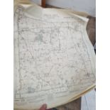
A COLLECTION OF LARGE SCALE ORDINANCE SURVEY AND OTHER MAPS.

Lot 61A
MOVIES:
Rare 1950s clapperboard white printed Prod, A Night To Remember then divided into Slate and Take. 8ins. x 6ins.

Lot 13
Collection of Maps
Collection of Maps including: Hertfordshire, 1840 and c.1880; Devonshire, c.1748 ; Cambridgeshire , c.1818 ; Bedfordshire; Isle of Thanet, ...

Lot 25
SPEED, John:
SPEED, John: Essex, devided into Hundreds, with the most antient and fayre Towne Colchester Described and other memorable Monuments observed. ...

Lot 63
VAN DEN AVELEN:
VAN DEN AVELEN: De Beschryving van de Reysen Pauli, en van de Andere Apostelen (Journeys of Apostle Paul). Amsterdam, c.1700. Hand-coloured an...

Lot 517
SIX BOXES OF BOOKS AND EPHEMERA, to include a school exercise book belonging to a George Picker, who
SIX BOXES OF BOOKS AND EPHEMERA, to include a school exercise book belonging to a George Picker, who went to Leadenham School, dated October 26th ...

John Speed 17th century engraved map of Bermuda, sold by Baskett and Chiswell, plate 40 x 53cm, English text verso

R W Seale, 18th century engraved map of North America and West Indies, Circa 1747, and Map of South America, both 38 x 48cm (plate)

Lot 204
A Kelly's Directory of Devon and Cornwall with maps 1926 and Kelly's Directory of Cornwall 1939 (20
A Kelly's Directory of Devon and Cornwall with maps 1926 and Kelly's Directory of Cornwall 1939 (20
Lot 250
MOUNTAINEERING.
MOUNTAINEERING. Whymper, Edward, Scrambles Amongst the Alps in the Years 1860-69, London: John Murray 1893, 4th edition, folding maps and plates, ...

Lot 363
SPEED, John.
SPEED, John. Devonshire with Excester Described, published by John Sudbury & George Humble 1623, hand coloured map, Exeter shown in an inset to on...
![[DEVON] BLAEU, Joan.](https://portal-images.azureedge.net/auctions-2024/bearne10150/images/9bf08fd8-a4c6-4b36-a926-b15000fc8d1a.jpg?w=155&h=155)
Lot 330
[DEVON] BLAEU, Joan.
[DEVON] BLAEU, Joan. Devonia vulgo Devon-Shire, hand coloured map, 1645 or later, latin text, f&g, 40cm x 52cm; together with MORDEN, Robert. Devo...
![[ATLAS] COLE and ROPER. Nightingale, Joseph.](https://portal-images.azureedge.net/auctions-2024/bearne10150/images/4bd431a9-b8cb-49bb-9b6a-b15000fc8b3f.jpg?w=155&h=155)
[ATLAS] COLE and ROPER. Nightingale, Joseph. English Topography: or, a series of … Counties of England and Wales. Accompanied by a Map of each Cou...