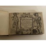
No Image Lot 660 Speed, John 1627 England, Wales, Scotland and Ireland with fronttispiece, distance tables and 63 660Speed, John 1627 England, Wales, Scotland and Ireland with fronttispiece, distance tables and 63 Unique Auctions Speed, John 1627 England, Wales, Scotland and Ireland with fronttispiece, distance tables and 63 maps - has a tear to page on Caernavonshire - a v... Timed
No Image Lot 103 A vintage jumper display stand, possibly Hebridean or other Scottish isles wool interest, height 103A vintage jumper display stand, possibly Hebridean or other Scottish isles wool interest, height 1818 Auctioneers A vintage jumper display stand, possibly Hebridean or other Scottish isles wool interest, height approx 86cm, extended width 172cm Timed
Reserve not met No Image Lot 76 A Coloured City Map Of Exeter Circa 1597 76A Coloured City Map Of Exeter Circa 1597 Winchcombe Auctions A Coloured City Map Of Exeter Circa 1597 Add to watchlist Timed
No Image Lot 519 20th Century, print on canvas, Bartholomew's One Inch Map of the Lake District, mounted on wooden 51920th Century, print on canvas, Bartholomew's One Inch Map of the Lake District, mounted on wooden 1818 Auctioneers 20th Century, print on canvas, Bartholomew's One Inch Map of the Lake District, mounted on wooden board, measuring 80cm x 90cm overall Timed
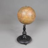
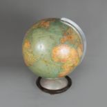
Reserve not met No Image Lot 7 Table Globe 7Table Globe Art Antique Gallery & Auctioneers E. P. Deutsch Table Globe, paper printed and described in German on original ebonized stand around 1900. 40 cm high. Add to watchlist Timed
Reserve not met No Image Lot 209 Mary STORK (1938-2007) Female in Repose 209Mary STORK (1938-2007) Female in Repose Lay's Auctioneers - Timed Mary STORK (1938-2007) Female in Repose Pastel on paper Information to the verso states it was previously sold in the estate sale of Rose Hil... Add to watchlist Timed
Reserve not met No Image Lot 79 A Hand Coloured 17th Century Framed Double Sided Map Of Cardiganshire 79A Hand Coloured 17th Century Framed Double Sided Map Of Cardiganshire Winchcombe Auctions A 17th Century Framed Double Sided Map Of Cardiganshire Add to watchlist Timed
No Image Lot 517 20th Century, monochrome print, A Lancashire map illustrating 'The Trials of the Lancashire 51720th Century, monochrome print, A Lancashire map illustrating 'The Trials of the Lancashire 1818 Auctioneers 20th Century, monochrome print, A Lancashire map illustrating 'The Trials of the Lancashire Witches', framed, not glazed, measuring 44cm x 55cm, &... Timed
No Image Lot 678 Outline of Nature of The British Isles in 2 volumes edited by Sir John Hammerton nicely bound in red 678Outline of Nature of The British Isles in 2 volumes edited by Sir John Hammerton nicely bound in red Unique Auctions Outline of Nature of The British Isles in 2 volumes edited by Sir John Hammerton nicely bound in red boards Timed
Reserve not met No Image Lot 71 Early Map Of London And The Surrounding Area 71Early Map Of London And The Surrounding Area Winchcombe Auctions Early Map Of London And The Surrounding Area Add to watchlist Timed
Reserve not met No Image Lot 94 A Framed Hand Coloured Map Of Glamorganshire 94A Framed Hand Coloured Map Of Glamorganshire Winchcombe Auctions A Framed Hand Coloured Map Of Glamorganshire Add to watchlist Timed
Reserve not met No Image Lot 213 A carton of assorted Ordnance Survey Maps mainly UK. 213A carton of assorted Ordnance Survey Maps mainly UK. 1818 Auctioneers A carton of assorted Ordnance Survey Maps mainly UK. Add to watchlist Timed
Reserve not met No Image Lot 38 *Local Interest - After Robert Morden (1650-1703, British), coloured engravings, Two illustrations 38*Local Interest - After Robert Morden (1650-1703, British), coloured engravings, Two illustrations 1818 Auctioneers *Local Interest - After Robert Morden (1650-1703, British), coloured engravings, Two illustrations of local interest - Maps of 'Cumberland' & 'Wes... Add to watchlist Timed
No Image Lot 688 In Darkest Africa, 1890 edition, wear to spine and map tear 688In Darkest Africa, 1890 edition, wear to spine and map tear Unique Auctions In Darkest Africa, 1890 edition, wear to spine and map tear Timed
Reserve not met No Image Lot 72 17th Century Hand Coloured Map Of Denbigh 7217th Century Hand Coloured Map Of Denbigh Winchcombe Auctions 17th Century Hand Coloured Map Of Denbigh Add to watchlist Timed
Reserve not met No Image Lot 73 A Collection Of Three Maps Including A Western And Eastern Hemispere And Africa Septentrionalis 73A Collection Of Three Maps Including A Western And Eastern Hemispere And Africa Septentrionalis Winchcombe Auctions A Collection Of Three Maps Including A Western And Eastern Hemispere And Africa Septentrionalis Add to watchlist Timed
Reserve not met No Image Lot 74 Turkey III Containing The Sothern Part Of Greece And Candia. Plus A Map Of France 74Turkey III Containing The Sothern Part Of Greece And Candia. Plus A Map Of France Winchcombe Auctions Turkey III Containing The Sothern Part Of Greece And Candia. Date 1829 Add to watchlist Timed
Reserve not met No Image Lot 80 A 17th Century Map Of Herefordshire 80A 17th Century Map Of Herefordshire Winchcombe Auctions A 17th Century Map Of Herefordshire Add to watchlist Timed
Reserve not met No Image Lot 82 A Hand Coloured Map Of Warwickshire (1650 - 1703) 82A Hand Coloured Map Of Warwickshire (1650 - 1703) Winchcombe Auctions A Hand Coloured Map Of Warwickshire (1650 - 1703) Add to watchlist Timed
Reserve not met No Image Lot 84 The Small Islands In The British Ocean By Rodert Morden (1650-1703) 84The Small Islands In The British Ocean By Rodert Morden (1650-1703) Winchcombe Auctions The Small Islands In The British Ocean By Rodert Morden (1650-1703) Add to watchlist Timed
Reserve not met No Image Lot 89 Fold Out Map Of Warwickshire Dated 1830 89Fold Out Map Of Warwickshire Dated 1830 Winchcombe Auctions Fold Out Map Of Warwickshire Dated 1830 Add to watchlist Timed
Reserve not met No Image Lot 90 A Collection Of 6 County Maps 90A Collection Of 6 County Maps Winchcombe Auctions A Collection Of 6 County Maps Add to watchlist Timed
No Image Lot 439 After Emmanuel Bowen (1694-1767, British), antiquarian map, A hand coloured illustration of Scotland 439After Emmanuel Bowen (1694-1767, British), antiquarian map, A hand coloured illustration of Scotland 1818 Auctioneers After Emmanuel Bowen (1694-1767, British), antiquarian map, A hand coloured illustration of Scotland and Westmorland, framed, mounted, and under g... Timed
No Image Lot 503 An Ordnance Survey Map, Sheet SD37, illustrating Cartmel Sands and surrounding area, scale 1:25,000, 503An Ordnance Survey Map, Sheet SD37, illustrating Cartmel Sands and surrounding area, scale 1:25,000, 1818 Auctioneers An Ordnance Survey Map, Sheet SD37, illustrating Cartmel Sands and surrounding area, scale 1:25,000, framed and under glass, measuring 45cm x 55cm... Timed
Reserve not met No Image Lot 295 2 W & A. K. JOHNSTON ENGRAVED MAPS OF IRELAND AND ITALY 18" X 22" 2952 W & A. K. JOHNSTON ENGRAVED MAPS OF IRELAND AND ITALY 18" X 22" Mid Devon Auctions 2 W & A. K. JOHNSTON ENGRAVED MAPS OF IRELAND AND ITALY 18" X 22" Add to watchlist Timed
Reserve not met No Image Lot 301 2 MAPS, ONE OF ITALY OTHER HUNGARY 13" X 12" 3012 MAPS, ONE OF ITALY OTHER HUNGARY 13" X 12" Mid Devon Auctions 2 MAPS, ONE OF ITALY OTHER HUNGARY 13" X 12" Add to watchlist Timed
Reserve not met No Image Lot 64 A large framed and glazed printed map of the British Isles. H.122 W.78.cm 64A large framed and glazed printed map of the British Isles. H.122 W.78.cm Criterion Auctioneers Ltd A large framed and glazed printed map of the British Isles. H.122 W.78.cm Add to watchlist Timed
Reserve not met No Image Lot 44 5 prints inc map of Essex 445 prints inc map of Essex Barry L Hawkins 5 prints inc map of Essex Add to watchlist Timed
Reserve not met No Image Lot 100 Walter Cox (American,1866-1930), The Celebration of the Fourth of June at Eton, hand coloured 100Walter Cox (American,1866-1930), The Celebration of the Fourth of June at Eton, hand coloured Keys Timed Walter Cox (American,1866-1930), The Celebration of the Fourth of June at Eton, hand coloured engraved map, signed in pencil by Cox and A.H. Wardl... Add to watchlist Timed
Reserve not met No Image Lot 61 10 UK County Maps 6110 UK County Maps Winchcombe Auctions 10 UK County Maps Add to watchlist Timed
Reserve not met No Image Lot 62 4 Country Maps Including Herefordshire And A Map Of England And Wales 624 Country Maps Including Herefordshire And A Map Of England And Wales Winchcombe Auctions 4 Country Maps Including Herefordshire And A Map Of England And Wales Add to watchlist Timed
Reserve not met No Image Lot 63 Robert Morden (1650 - 1703) Coloured Map Of Stafford Shire 63Robert Morden (1650 - 1703) Coloured Map Of Stafford Shire Winchcombe Auctions Robert Morden (1650 - 1703) Coloured Map Of Stafford Shire Add to watchlist Timed
Reserve not met No Image Lot 64 Two Huntingshire Maps And One Worcestershire 64Two Huntingshire Maps And One Worcestershire Winchcombe Auctions Two Huntingshire Maps And One Worcestershire Add to watchlist Timed
Reserve not met No Image Lot 65 Two Coloured Engraved Maps. Dorsetshire and Cornwall 65Two Coloured Engraved Maps. Dorsetshire and Cornwall Winchcombe Auctions Two Coloured Engraved Maps. Dorsetshire and Cornwall Add to watchlist Timed
Reserve not met No Image Lot 66 A Collection Of Six Maps Including A Cardigan Road Map 66A Collection Of Six Maps Including A Cardigan Road Map Winchcombe Auctions A Collection Of Six Maps Including A Cardigan Road Map Add to watchlist Timed
Reserve not met No Image Lot 67 10 UK County Maps 6710 UK County Maps Winchcombe Auctions 10 UK County Maps Add to watchlist Timed
Reserve not met No Image Lot 68 Worcestershire And Herefordshire Map 68Worcestershire And Herefordshire Map Winchcombe Auctions Worcestershire And Herefordshire Map Add to watchlist Timed
Reserve not met No Image Lot 69 Map Of Monmouthshire And Huntingdonshire 69Map Of Monmouthshire And Huntingdonshire Winchcombe Auctions Map Of Monmouthshire And Huntingdonshire Add to watchlist Timed
Reserve not met No Image Lot 70 Map Of Warwickshire Dated 1834 70Map Of Warwickshire Dated 1834 Winchcombe Auctions Map Of Warwickshire Dated 1834 Add to watchlist Timed
Reserve not met No Image Lot 77 A Framed Hand Coloured Map Of Herefordshire 77A Framed Hand Coloured Map Of Herefordshire Winchcombe Auctions A Framed Hand Coloured Map Of Herefordshire Add to watchlist Timed
Reserve not met No Image Lot 78 Map Of Monmouthshire Divided Into Hundreds 78Map Of Monmouthshire Divided Into Hundreds Winchcombe Auctions Map Of Monmouthshire Divided Into Hundreds Add to watchlist Timed
Reserve not met No Image Lot 81 A Road Map From St Davids to Holywell 81A Road Map From St Davids to Holywell Winchcombe Auctions A Road Map From St Davids to Holywell Add to watchlist Timed
Reserve not met No Image Lot 83 A Dorset Map By Robert Morden (1650-1703) 83A Dorset Map By Robert Morden (1650-1703) Winchcombe Auctions A Dorset Map By Robert Morden (1650-1703) Add to watchlist Timed
Reserve not met No Image Lot 85 A Hand Coloured Map Of Leicestershire By Robert Morden (1650-1703) 85A Hand Coloured Map Of Leicestershire By Robert Morden (1650-1703) Winchcombe Auctions A Hand Coloured Map Of Leicestershire By Robert Morden (1650-1703) Add to watchlist Timed
Reserve not met No Image Lot 86 A Hand Coloured Map Of North Wales 86A Hand Coloured Map Of North Wales Winchcombe Auctions A Hand Coloured Map Of North Wales Add to watchlist Timed
Reserve not met No Image Lot 87 A 19th Century Map Of Wales And England 87A 19th Century Map Of Wales And England Winchcombe Auctions A 19th Century Map Of Wales And England Add to watchlist Timed
Reserve not met No Image Lot 88 A 19th Century Hand Coloured Map Of Gurnsey 88A 19th Century Hand Coloured Map Of Gurnsey Winchcombe Auctions A 19th Century Hand Coloured Map Of Gurnsey Add to watchlist Timed
Reserve not met No Image Lot 91 A Collected Of 4 Framed Maps 91A Collected Of 4 Framed Maps Winchcombe Auctions A Collection Of 4 UK County Maps Add to watchlist Timed
Reserve not met No Image Lot 220 A small selection of vintage Ordnance Survey maps and similar covering Britain and Europe. 220A small selection of vintage Ordnance Survey maps and similar covering Britain and Europe. 1818 Auctioneers A small selection of vintage Ordnance Survey maps and similar covering Britain and Europe. Add to watchlist Timed
Reserve not met No Image Lot 242 DEVONSHIRE. Leaf from Britannia Depicta 242DEVONSHIRE. Leaf from Britannia Depicta Bearnes Hampton & Littlewood DEVONSHIRE. Leaf from Britannia Depicta or Ogilby Improv'd, with strip map of route NW from Exeter via Crediton, and overleaf Barnstaple, Ilfracom... Add to watchlist Timed
Reserve not met No Image Lot 119 Ray-Ban Sunglasses Black Round Double Bridge Black Frame Edition 119Ray-Ban Sunglasses Black Round Double Bridge Black Frame Edition James Auctioneers Ltd Ray-Ban Unisex Sunglasses Black Round Double Bridge Black Frame- appear unworn examples with as pictured all relevant original paperwork and packa... Add to watchlist Timed
Reserve not met No Image Lot 18 Circuit Maps signed by Michele Alboreto and Nelson Piquet, 18Circuit Maps signed by Michele Alboreto and Nelson Piquet, Bonhams Circuit Maps signed by Michele Alboreto and Nelson Piquet, one circuit Kyalami, annotated in blue pen and signed by Nelson Piquet in blue pen,30 x... Add to watchlist Timed
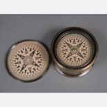
Reserve not met No Image Lot 171 Kelvin & Hughes Compass 171Kelvin & Hughes Compass Art Antique Gallery & Auctioneers E. P. Deutsch Kelvin & Hughes Compass, in metal box. Movable. 20th Century. 8 cm diameter. Add to watchlist Timed
Reserve not met No Image Lot 9 Columbus Globe 9Columbus Globe Art Antique Gallery & Auctioneers E. P. Deutsch Columbus Globe, paper with colour printed card, on metal base. Berlin around 1960. Add to watchlist Timed
Reserve not met No Image Lot 402 North & East Riding Yorkshire 1895 Antique Victorian Coloured Map. 402North & East Riding Yorkshire 1895 Antique Victorian Coloured Map. William George Title: North & East Riding Yorkshire 1895 Antique Victorian Coloured Map. Description: North & East Riding Yorkshire 1895 Antique Vict... Add to watchlist Timed
Reserve not met No Image Lot 403 The Isle of Man 1895 Antique Victorian Coloured Map. 403The Isle of Man 1895 Antique Victorian Coloured Map. William George Title: The Isle of Man 1895 Antique Victorian Coloured Map. Description: The Isle of Man 1895 Antique Victorian Coloured Map. This ... Add to watchlist Timed
Reserve not met No Image Lot 404 Lancashire North 1895 Antique Victorian Detailed Coloured Map. 404Lancashire North 1895 Antique Victorian Detailed Coloured Map. William George Title: Lancashire North 1895 Antique Victorian Detailed Coloured Map. Description: Lancashire North 1895 Antique Victorian Coloured Ma... Add to watchlist Timed
Reserve not met No Image Lot 405 Environs Liverpool & Manchester 1895 Antique Victorian Coloured Map. 405Environs Liverpool & Manchester 1895 Antique Victorian Coloured Map. William George Title: Environs Liverpool & Manchester 1895 Antique Victorian Coloured Map. Description: Environs Liverpool & Manchester 1895 Antiqu... Add to watchlist Timed
Reserve not met No Image Lot 406 Lake District & Cumbria 1895 Antique Victorian Coloured Map. 406Lake District & Cumbria 1895 Antique Victorian Coloured Map. William George Title: Lake District & Cumbria 1895 Antique Victorian Coloured Map. Description: Lake District & Cumbria 1895 Antique Victorian Colour... Add to watchlist Timed
Reserve not met No Image Lot 407 County Cheshire 1895 Antique Victorian Detailed Coloured Map. 407County Cheshire 1895 Antique Victorian Detailed Coloured Map. William George Title: County Cheshire 1895 Antique Victorian Detailed Coloured Map. Description: County Cheshire 1895 Antique Victorian Coloured Map.... Add to watchlist Timed