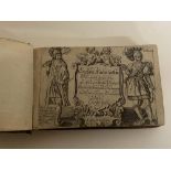
Reserve not met No Image Lot 660 Speed, John 1627 England, Wales, Scotland and Ireland with fronttispiece, distance tables and 63 660Speed, John 1627 England, Wales, Scotland and Ireland with fronttispiece, distance tables and 63 Unique Auctions Speed, John 1627 England, Wales, Scotland and Ireland with fronttispiece, distance tables and 63 maps - has a tear to page on Caernavonshire - a v... Add to watchlist Timed
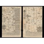
Reserve not met No Image Lot 212 Bowen 290 Yrs Old Detailed Road Map Whitby to Durham Newcastle North East. 212Bowen 290 Yrs Old Detailed Road Map Whitby to Durham Newcastle North East. William George Title: Bowen 290 Yrs Old Detailed Road Map Whitby to Durham Newcastle North East. Description: Bowen 290 Yrs Old Detailed Road Map ... Add to watchlist Timed
Reserve not met No Image Lot 53 Jan Huygen Van & Hendrik Floris Van Langren: 53Jan Huygen Van & Hendrik Floris Van Langren: Sworders Timed Jan Huygen Van & Hendrik Floris Van Langren: LINSCHOTEN, Deliniantur in hac tabula, Orae Maritimae Abexiae, freti Mecani; al Maris Rubri; Ara... Add to watchlist Timed
Reserve not met No Image Lot 41 Ordnance Survey of Scotland: 41Ordnance Survey of Scotland: Sworders Timed Ordnance Survey of Scotland: Complete set. 92 colour maps , each dissected into 4 sections laid on linen, with numbering tabs, preserved in... Add to watchlist Timed
Reserve not met No Image Lot 43 FOLIO SOCIETY, Limited Edition: 43FOLIO SOCIETY, Limited Edition: Sworders Timed FOLIO SOCIETY, Limited Edition: QUEEN MARY ATLAS. Two Volumes. Folio Society, 2005. Limited Edition No. 581 of 1000 . Folio, Bound in full c... Add to watchlist Timed
Reserve not met No Image Lot 67 MAP OF TURKEY: 67MAP OF TURKEY: Sworders Timed MAP OF TURKEY: Ortelius, Abraham: Turcici Imperii Descriptio . London, 1606, English text to rear (A rare English edition, only 300 were printe... Add to watchlist Timed
Reserve not met No Image Lot 5 Walker (J & C): 5Walker (J & C): Sworders Timed Walker (J & C): A Geological Map of England and Wales. Published by Charles Knight for the SDUK, 1843. Hand-coloured, mounted, framed and gla... Add to watchlist Timed
Reserve not met No Image Lot 42 Ordnance Survey of England and Wales: 42Ordnance Survey of England and Wales: Sworders Timed Ordnance Survey of England and Wales: Complete set of the 7th Series. 190 one-inch colour maps , each dissected into 6 sections laid on li... Add to watchlist Timed
Reserve not met No Image Lot 12 SCOTLAND (4 Maps): 12SCOTLAND (4 Maps): Sworders Timed SCOTLAND (4 Maps): Collins, Captain Greenvile: The East Coast of Scotland with the Isles of Orkney and Shetland . c.1693, hand-coloured and mou... Add to watchlist Timed
Reserve not met No Image Lot 13 Collection of Maps 13Collection of Maps Sworders Timed Collection of Maps including: Hertfordshire, 1840 and c.1880; Devonshire, c.1748 ; Cambridgeshire , c.1818 ; Bedfordshire; Isle of Thanet, ... Add to watchlist Timed
Reserve not met No Image Lot 29 Bowen, E: 29Bowen, E: Sworders Timed Bowen, E: An Accurate map of Cambridgeshire divided into its hundreds. c.1760. Mounted, framed and glazed. Glass broken , 52 x 70cm.; Morden... Add to watchlist Timed
Reserve not met No Image Lot 38 Collection of MAPS, 38Collection of MAPS, Sworders Timed Collection of MAPS, Hand-coloured, mounted, framed and glazed: Morden: Somersetshire; Ogilby (3 maps): The road from Exeter to Dorchester; From... Add to watchlist Timed
Reserve not met No Image Lot 57 JANSSONIUS: 57JANSSONIUS: Sworders Timed JANSSONIUS: SOUTH AMERICA: 1- Freti Magellanici ac novi Freti vulgo le Maire exactissima delineatio . Amsterdam, c.1633. Hand-coloured, 37 x 48... Add to watchlist Timed
Reserve not met No Image Lot 97 Two David & Charles reprints of Ordnance Survey maps illustrating Kendal, & Lancaster & Blackpool, 97Two David & Charles reprints of Ordnance Survey maps illustrating Kendal, & Lancaster & Blackpool, 1818 Auctioneers Two David & Charles reprints of Ordnance Survey maps illustrating Kendal, & Lancaster & Blackpool, together with two others illustrating Lancaster... Add to watchlist Timed
Reserve not met No Image Lot 248 Ancient Region of Palestine Charles Smith Classical 215 Antique Years Old Map. 248Ancient Region of Palestine Charles Smith Classical 215 Antique Years Old Map. William George Title: Ancient Region of Palestine Charles Smith Classical 215 Antique Years Old Map. Description: Ancient Region of Palestine Charles... Add to watchlist Timed
Reserve not met No Image Lot 15 GREENWOOD, C & J: 15GREENWOOD, C & J: Sworders Timed GREENWOOD, C & J: Map of the County of Kent from an actual survey made in the years 1819 & 1820. 1829, hand-coloured, mounted, framed and glaz... Add to watchlist Timed
Reserve not met No Image Lot 30 WALES (4 Maps): 30WALES (4 Maps): Sworders Timed WALES (4 Maps): SPEED, John: Merionethshire Described 1610. Hand-coloured, 50 x 38cm; Flint shire, c.1610. Hand-coloured, 50 x 38cm; Montgo... Add to watchlist Timed
Reserve not met No Image Lot 2 JANVIER, Jean: 2JANVIER, Jean: Sworders Timed JANVIER, Jean: Les Isles Britanniques Comprenant les Royaumes d'Angleterre d'Ecosse et d'Irlande. c.1762, hand-coloured and mounted. 44 x 31cm... Add to watchlist Timed
Reserve not met No Image Lot 20 Smith, C: 20Smith, C: Sworders Timed Smith, C: A New Map of the County of Kent Divided into Lathes &c. c.1804. Hand-coloured, mounted, framed and glazed, 44 x 49cm Add to watchlist Timed
Reserve not met No Image Lot 34 SPEED, John: 34SPEED, John: Sworders Timed SPEED, John: SHROPSHYRE DESCRIBED Shropshire. c.1649, hand-coloured. 51 x 38cm : Shrowesbury Described the sittuation of Shrowesbury Shewed, ... Add to watchlist Timed
Reserve not met No Image Lot 39 MAPS: 39MAPS: Sworders Timed MAPS: 1- Norden, J: Hamshire Olim Pars Belgarum . c.1610, hand-coloured, mounted, framed and glazed; 2- Saxton, C : Mongomery Comitatus qui ol... Add to watchlist Timed
Reserve not met No Image Lot 252 Palestine the Holy Land The Dead Sea, Damascus, Galilee Coloured Antique Map 252Palestine the Holy Land The Dead Sea, Damascus, Galilee Coloured Antique Map William George Title: Palestine the Holy Land The Dead Sea, Damascus, Galilee Coloured Antique Map Description: Palestine the Holy Land The Dead Sea,... Add to watchlist Timed
Reserve not met No Image Lot 253 Westminster Camden Chelsea Wandsworth Kensington London Antique Map. 253Westminster Camden Chelsea Wandsworth Kensington London Antique Map. William George Title: Westminster Camden Chelsea Wandsworth Kensington London Antique Map. Description: Westminster Camden Chelsea Wandsworth Kensing... Add to watchlist Timed
Reserve not met No Image Lot 517 20th Century, monochrome print, A Lancashire map illustrating 'The Trials of the Lancashire 51720th Century, monochrome print, A Lancashire map illustrating 'The Trials of the Lancashire 1818 Auctioneers 20th Century, monochrome print, A Lancashire map illustrating 'The Trials of the Lancashire Witches', framed, not glazed, measuring 44cm x 55cm, &... Add to watchlist Timed
Reserve not met No Image Lot 31 SMITH, C: 31SMITH, C: Sworders Timed SMITH, C: A NEW MAP of the COUNTY of STAFFORD Divided into Hundreds.1804. Hand-coloured 42 x 48cm; A New Map of the County of Berks, divided... Add to watchlist Timed
Reserve not met No Image Lot 51 MAPS: 1- (HOLY LAND.) Wells, Edward, 51MAPS: 1- (HOLY LAND.) Wells, Edward, Sworders Timed MAPS: 1- (HOLY LAND.) Wells, Edward, A New Map Shewing the Travels of the Patriarchs... c.1720, hand-coloured, mounted, framed and glazed ; 2- ... Add to watchlist Timed
Reserve not met No Image Lot 65 Wells: 65Wells: Sworders Timed Wells: New Map of the North Part of Antient Africa , c.1700. Hand-coloured, 34 x 48cm; Weigel: Syria propria cum Phoenice studio . c.1720, Han... Add to watchlist Timed
Reserve not met No Image Lot 190 A small carton of vintage and modern maps and guides mainly Europe. 190A small carton of vintage and modern maps and guides mainly Europe. 1818 Auctioneers A small carton of vintage and modern maps and guides mainly Europe. Add to watchlist Timed
Reserve not met No Image Lot 156 Peterborough & Longville Antique Railway Junction Diagram Map-60. 156Peterborough & Longville Antique Railway Junction Diagram Map-60. William George Title: Peterborough & Longville Antique Railway Junction Diagram Map-60. Description: Peterborough & Longville Antique Railway Junctio... Add to watchlist Timed
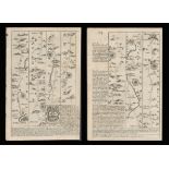
Reserve not met No Image Lot 211 Bowen 290 Yrs Old Detailed Road Map London-Norwich Puckeridge, Newmarket. 211Bowen 290 Yrs Old Detailed Road Map London-Norwich Puckeridge, Newmarket. William George Title: Bowen 290 Yrs Old Detailed Road Map London-Norwich Puckeridge, Newmarket. Description: Bowen 290 Yrs Old Detailed Road Map L... Add to watchlist Timed
Reserve not met No Image Lot 217 Bowen 290 Yrs Old Detailed Road Map Derbyshire High Peak Buxton Derby. 217Bowen 290 Yrs Old Detailed Road Map Derbyshire High Peak Buxton Derby. William George Title: Bowen 290 Yrs Old Detailed Road Map Derbyshire High Peak Buxton Derby. Description: Bowen 290 Yrs Old Detailed Road Map Derb... Add to watchlist Timed
Reserve not met No Image Lot 226 Bowen 290 Yrs Old Detailed Road Map Oxford Buckingham, Bedford, Cambridge. 226Bowen 290 Yrs Old Detailed Road Map Oxford Buckingham, Bedford, Cambridge. William George Title: Bowen 290 Yrs Old Detailed Road Map Oxford Buckingham, Bedford, Cambridge. Description: Bowen 290 Yrs Old Detailed Road Map ... Add to watchlist Timed
Reserve not met No Image Lot 233 Bowen 290 Yrs Old Detailed Road Map Cornwall Padstow Camleford. 233Bowen 290 Yrs Old Detailed Road Map Cornwall Padstow Camleford. William George Title: Bowen 290 Yrs Old Detailed Road Map Cornwall Padstow Camleford. Description: Bowen 290 Yrs Old Detailed Road Map Cornwall Pa... Add to watchlist Timed
Reserve not met No Image Lot 251 Antique Palestine Religious Map of Holy Land As Allotted By Joshua. 251Antique Palestine Religious Map of Holy Land As Allotted By Joshua. William George Title: Antique Palestine Religious Map of Holy Land As Allotted By Joshua. Description: Antique Palestine Religious Map of Holy Land A... Add to watchlist Timed
Reserve not met No Image Lot 255 Cambridgeshire 200 Yr Old Engraved Hand Coloured King George IV Antique Map & Text. 255Cambridgeshire 200 Yr Old Engraved Hand Coloured King George IV Antique Map & Text. William George Title: Cambridgeshire 200 Yr Old Engraved Hand Coloured King George IV Antique Map & Text. Description: Cambridgeshire Engraved Hand C... Add to watchlist Timed
Reserve not met No Image Lot 257 Hampshire 200 Yr Old Engraved Hand Coloured King George IV Antique Map & Text. 257Hampshire 200 Yr Old Engraved Hand Coloured King George IV Antique Map & Text. William George Title: Hampshire 200 Yr Old Engraved Hand Coloured King George IV Antique Map & Text. Description: Hampshire Engraved Hand Coloured Ge... Add to watchlist Timed
Reserve not met No Image Lot 267 Surrey 200 Yr Old Engraved Hand Coloured George IV Antique Map & Text. 267Surrey 200 Yr Old Engraved Hand Coloured George IV Antique Map & Text. William George Title: Surrey 200 Yr Old Engraved Hand Coloured George IV Antique Map & Text. Description: Surrey Engraved Hand Coloured George IV Ant... Add to watchlist Timed
Reserve not met No Image Lot 269 Wiltshire 200 Yr Old Engraved Hand Coloured George IV Antique Map & Text. 269Wiltshire 200 Yr Old Engraved Hand Coloured George IV Antique Map & Text. William George Title: Wiltshire 200 Yr Old Engraved Hand Coloured George IV Antique Map & Text. Description: Wiltshire Engraved Hand Coloured George ... Add to watchlist Timed
Reserve not met No Image Lot 271 Bedfordshire Antique Copper Engraved King George IV Map by Sidney Hall. 271Bedfordshire Antique Copper Engraved King George IV Map by Sidney Hall. William George Title: Bedfordshire Antique Copper Engraved King George IV Map by Sidney Hall. Description: Bedfordshire Antique Copper Engraved Georg... Add to watchlist Timed
Reserve not met No Image Lot 272 Cambridgeshire Antique Copper Engraved George IV Map by Sidney Hall. 272Cambridgeshire Antique Copper Engraved George IV Map by Sidney Hall. William George Title: Cambridgeshire Antique Copper Engraved George IV Map by Sidney Hall. Description: Cambridgeshire Antique Copper Engraved George... Add to watchlist Timed
Reserve not met No Image Lot 273 England & Wales Antique Large Coloured Detailed Copper Engraved Map. 273England & Wales Antique Large Coloured Detailed Copper Engraved Map. William George Title: England & Wales Antique Large Coloured Detailed Copper Engraved Map. Description: England & Wales Antique Large Coloured Detail... Add to watchlist Timed
Reserve not met No Image Lot 284 Wales Anglesey Antique Copper Engraved George IV Map by Sidney Hall. 284Wales Anglesey Antique Copper Engraved George IV Map by Sidney Hall. William George Title: Wales Anglesey Antique Copper Engraved George IV Map by Sidney Hall. Description: Wales Anglesey Antique Copper Engraved George... Add to watchlist Timed
Reserve not met No Image Lot 285 Wales Brecknockshire Antique Copper Engraved George IV Map by Sidney Hall. 285Wales Brecknockshire Antique Copper Engraved George IV Map by Sidney Hall. William George Title: Wales Brecknockshire Antique Copper Engraved George IV Map by Sidney Hall. Description: Wales Brecknockshire Antique Copper Eng... Add to watchlist Timed
Reserve not met No Image Lot 294 Wales Radnorshire Antique Copper Engraved George IV Map by Sidney Hall. 294Wales Radnorshire Antique Copper Engraved George IV Map by Sidney Hall. William George Title: Wales Radnorshire Antique Copper Engraved George IV Map by Sidney Hall. Description: Wales Radnorshire Antique Copper Engraved ... Add to watchlist Timed
Reserve not met No Image Lot 688 In Darkest Africa, 1890 edition, wear to spine and map tear 688In Darkest Africa, 1890 edition, wear to spine and map tear Unique Auctions In Darkest Africa, 1890 edition, wear to spine and map tear Add to watchlist Timed
Reserve not met No Image Lot 213 A carton of assorted Ordnance Survey Maps mainly UK. 213A carton of assorted Ordnance Survey Maps mainly UK. 1818 Auctioneers A carton of assorted Ordnance Survey Maps mainly UK. Add to watchlist Timed
Reserve not met No Image Lot 62 Two framed and glazed maps of Northamptonshire. Largest H.39 W.46cm. 62Two framed and glazed maps of Northamptonshire. Largest H.39 W.46cm. Criterion Auctioneers Ltd Two framed and glazed maps of Northamptonshire. Largest H.39 W.46cm. Add to watchlist Timed
Reserve not met No Image Lot 63 A framed and glazed map of Scotland. H.52 W.63cm. 63A framed and glazed map of Scotland. H.52 W.63cm. Criterion Auctioneers Ltd A framed and glazed map of Scotland. H.52 W.63cm. Add to watchlist Timed
Reserve not met No Image Lot 64 Two framed and glazed maps; Gloucestershire and Wiltshire. Largest H.40 W.47cm. 64Two framed and glazed maps; Gloucestershire and Wiltshire. Largest H.40 W.47cm. Criterion Auctioneers Ltd Two framed and glazed maps; Gloucestershire and Wiltshire. Largest H.40 W.47cm. Add to watchlist Timed
Reserve not met No Image Lot 65 A pair of framed and glazed maps along with a similar map. Largest H.46 W.56cm. 65A pair of framed and glazed maps along with a similar map. Largest H.46 W.56cm. Criterion Auctioneers Ltd A pair of framed and glazed maps along with a similar map. Largest H.46 W.56cm. Add to watchlist Timed
Reserve not met No Image Lot 137 Garnqueen, Gartsherrie, Whifflet Scotland Antique Railway Junction Map-28. 137Garnqueen, Gartsherrie, Whifflet Scotland Antique Railway Junction Map-28. William George Title: Garnqueen, Gartsherrie, Whifflet Scotland Antique Railway Junction Map-28. Description: Garnqueen, Gartsherrie, Whifflet Scotla... Add to watchlist Timed
Reserve not met No Image Lot 140 Elgin, Keith & Portessie Scotland Antique Railway Junction Map-38. 140Elgin, Keith & Portessie Scotland Antique Railway Junction Map-38. William George Title: Elgin, Keith & Portessie Scotland Antique Railway Junction Map-38. Description: Elgin, Keith & Portessie Scotland Antique Railw... Add to watchlist Timed
Reserve not met No Image Lot 143 Challoch, Stranraer, Scotland Antique Railway Junction Map-88. 143Challoch, Stranraer, Scotland Antique Railway Junction Map-88. William George Title: Challoch, Stranraer, Scotland Antique Railway Junction Map-88. Description: Challoch, Stranraer, Scotland Antique Railway Junct... Add to watchlist Timed
Reserve not met No Image Lot 165 Retford, Tuxford, Boughton Antique Railway Junction Diagram Map-15. 165Retford, Tuxford, Boughton Antique Railway Junction Diagram Map-15. William George Title: Retford, Tuxford, Boughton Antique Railway Junction Diagram Map-15. Description: Retford, Tuxford, Boughton Antique Railway Jun... Add to watchlist Timed
Reserve not met No Image Lot 176 Lincoln Greetwell Washingborough Antique Railway Junction Map-41. 176Lincoln Greetwell Washingborough Antique Railway Junction Map-41. William George Title: Lincoln Greetwell Washingborough Antique Railway Junction Map-41. Description: Lincoln Greetwell Washingborough Antique Railway... Add to watchlist Timed
Reserve not met No Image Lot 179 Craven Arms, Tenbury, Wellington Antique Railway Junction Map-19. 179Craven Arms, Tenbury, Wellington Antique Railway Junction Map-19. William George Title: Craven Arms, Tenbury, Wellington Antique Railway Junction Map-19. Description: Craven Arms, Tenbury, Wellington Antique Railway... Add to watchlist Timed
Reserve not met No Image Lot 213 Bowen 290 Yrs Old Detailed Road Map Whitby Malton Scarborough. 213Bowen 290 Yrs Old Detailed Road Map Whitby Malton Scarborough. William George Title: Bowen 290 Yrs Old Detailed Road Map Whitby Malton Scarborough. Description: Bowen 290 Yrs Old Detailed Road Map Whitby Malto... Add to watchlist Timed
Reserve not met No Image Lot 214 Bowen 290 Yrs Old Road Whitby Morton Durham Sunderland Tynemouth Map. 214Bowen 290 Yrs Old Road Whitby Morton Durham Sunderland Tynemouth Map. William George Title: Bowen 290 Yrs Old Road Whitby Morton Durham Sunderland Tynemouth Map. Description: Bowen 290 Yrs Old Road Whitby Morton Durham... Add to watchlist Timed
Reserve not met No Image Lot 215 Bowen 290 Yrs Old Detailed Road Map Arms of the City of Durham & Newcastle. 215Bowen 290 Yrs Old Detailed Road Map Arms of the City of Durham & Newcastle. William George Title: Bowen 290 Yrs Old Detailed Road Map Arms of the City of Durham & Newcastle. Description: Bowen 290 Yrs Old Detailed Road Map... Add to watchlist Timed
Reserve not met No Image Lot 216 Bowen 290 Yrs Old Road Map Scotland Cumberland Northumberland Kelso. 216Bowen 290 Yrs Old Road Map Scotland Cumberland Northumberland Kelso. William George Title: Bowen 290 Yrs Old Road Map Scotland Cumberland Northumberland Kelso. Description: Bowen 290 Yrs Old Road Map Scotland Cumberla... Add to watchlist Timed