We found 186 price guide item(s) matching your search
There are 186 lots that match your search criteria. Subscribe now to get instant access to the full price guide service.
Click here to subscribe- List
- Grid
-
186 item(s)/page
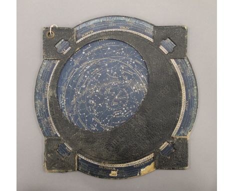

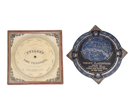
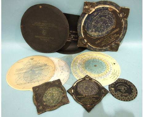
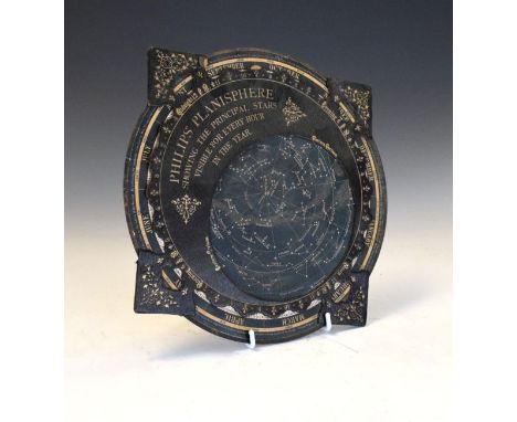
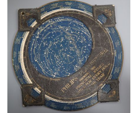
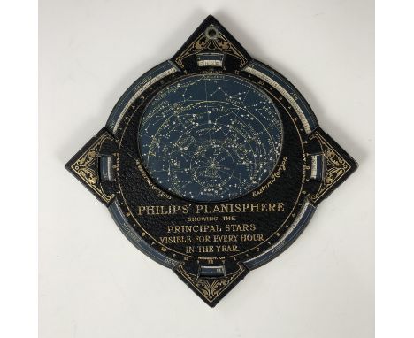
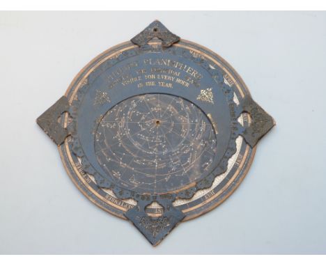
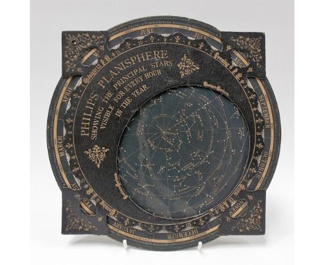
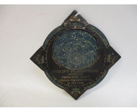
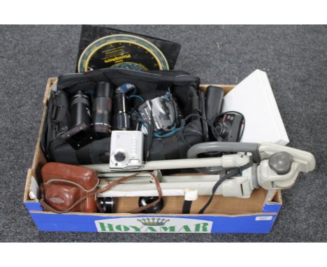
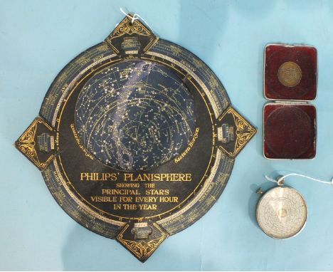
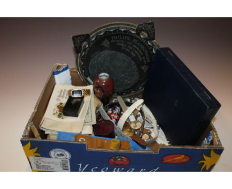
Lot 75
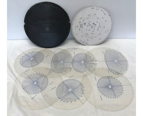
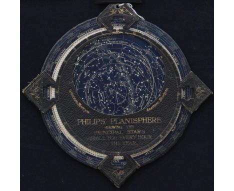
A PALMER'S COMPUTING SCALE AND FULLER'S TIME TELEGRAPH CIRCULAR SLIDE RULEPrinted by John E. Fuller, Boston, 1847The first side labelled PALMER'S, COMPUTING SCALE, IMPROVED BY, FULLER. and variously inscribed with accreditations including Entered according to Act of Congress in the year 1843 by Aaron Palmer in the Clerks Office of the District Court of the State of Massachusetts, and by J.E. Fuller 1847, over Engraved by George G. Smith, 188 Washington St. Boston to the centre of the revolving disc annotated with various computational scales with instruction Use the inner circle for Dollars, Cents & Mills, or Pounds Shillings & Pence, the reverse labelled FULLER'S, TIME TELEGRAPH with accreditation Entered according to Act of Congress in the year 1847 by John E. Fuller in the Clerks Office of the District Court of the State of Massachusetts, over Engraved by G.G. Smith, Boston to the centre within scales divided for annual calendar revolving within various computational scales to allow calculation of numbers of days or weeks between two dates and with two blocks of text titled Directions for weeks and Directions for days, with anthemion and scroll printed spandrel decoration to angles, with a PHILIPS' PLANISPHERE by George Philip and Son Limited, London, early 20th century with circular card printed with celestial map within outer calendar scale rotating within sleeve pierced with aperture for revealing the nights sky at any given date of the year labelled in gilt PHILIPS' PLANISPHERE, SHOWING THE PRINCIPAL STARS, VISIBLE FOR EVERY HOUR, IN THE YEAR to centre and with EXPLANATION test to verso (2).The circular slide rule 28.5cm (11.25ins) square; the planisphere 12.25ins (31cm) wide. Provenance: The horological library of Lawrance Hurst.

Lot 895
Naturwissenschaften - Astrologie - Medizin - Geographie - - Rufus Festus Avienus. Carmina. Flaviano Myrmeico v. c. suo salutem. Ed. Victor Pisanus. Mit 38 Holzschnitten. Venedig, Antonio de Strata, 25. X. 1488. 115 (von 122) nn. Bl. 19,5 x 14 cm. Späterer flexibler Pergamentband (etwas gebräunt, wenig fleckig). Erste Ausgabe. - GW 3131 - HC 2224 - BMC V, 294 - Pell 1673. - Breitrandiges Exemplar der ersten Ausgabe mit der ersten Sternenkarte in einem Buch gedruckt hier als Planisphere. Dieses eindrucksvolle medizinisch-geographisch und astrologische Kompendium, das von Pisanos ediert wurde, beinhaltet 6 Abhandlungen davon 3 in Erstausgabe. Der Band beinhaltet u.a. die Phaenomena des Aratus, die lateinische Übersetzung von De situ orbis von Periegetres mit dem Kommentar von Germanicus, sowie das Liber Medicinae ein astrologisch-medizinisches Gedicht von Serenus. Neben medizinischen Behandlungen werden dort u.a. auch magische Formeln wie erstmals das abracadabra zur Behandlung des Fiebers beschrieben- - Ohne die Blätter a1(weiß)-a3, p1-2, p7-8(weiß). - Blatt g8 weiß. - Blatt b1 mit Eckausriss und Textverlust. Anfangs lose, einige Blätter stärker gebräunt bzw. wasserrandig, wenige Anstreichungen und alte Annotationen. With 38 woodcuts. First edition copy with wide margins with the first star map in a book printed here as Planisphere. This impressive medical-geographical and astrological compendium edited by Pisanos contains 6 treatises, 3 of which are first editions. The volume contains, among others, the Phaenomena of Aratus, the Latin translation of De situ orbis by Periegetres with the commentary by Germanicus, as well as the Liber Medicinae, an astrological-medical poem by Serenus. In addition to medical treatments, magical formulas such as the abracadabra for the treatment of fever are described there for the first time. - Excluding leaves a1(white)-a3, p1-2, p7-8(white). - Leaf g8 white. - Leaf b1 with corner tear and loss of text. Loose at the beginning, some leaves more browned resp. waterstained, few annotations and old annotations.

Lot 207
'A New Map of Turkey in Europe', 'A New Map of Europe' by J. Bayly, both published by Harrison & Co. in "The Geographical Magazine 1784"; Map L'itineraire Ida Pfeiffer Voyage au tour du monde 1883, Hachette & Co., 'Planisphere du Monde de la Sphere, Mallet's Description de l'Univers; Duche de Toscane, Systeme de Descartes, Mallelt's, all 1683; Vagoundy Map of Northern Portugal, published by Gilles Robert, 1749; Map of Switzerland by J Lodge, published by C Cooke, 1810; A Map of the Earth illustrating the transit of Venus, June 6th, 1761; The Orbit of the Earth, Toms-Pluche 1747; Plan de la Ville Constantinople by Jacques-Nicolas Bellin, 1755;The Spanish Invincible Armada, Universal Magazine, 1750 for J Hinton; North Greece during Ottoman Empire by Delisle, 1794; Southern Greece, text in Latin, by Delisle, 1794; Three maps of ancient Greece from Philipp, 1711; Map of ancient Persia by Culverius, 1710; Map of ancient Greece by Santini, 1784; The World in Hemispheres with comparative heights of mountains, published by Holloway, London (15)

Lot 45
Astronomie - - Bartsch Jacob. Usus astronomicus planisphaerii stellati, seu vice - globi coelestis in plano delieanti compendiaria introdvctio, ostendens breviter ac perspicue, quomodo tam sidera praecipua, fixa pariter atque erratica noctu in coelo. Mit gestochener Titelbordüre, 4 (2 gefalteten) Kupfertafeln und 3 mehrfach gefalteten gestochenen Sternekarten (später eingebunden). Straßburg, Jacob von der Heyden, Chalcographa, um 1625. 5 Bl. (das letzte weiß), 80 S. 20,5 x 15 cm. - Angebunden: Derselbe. Praxis compendiosa tabularum astronomicarum et problematum, ad certiorem & commodiorem planisphaerii stellati ... pertinentium ... 6 Teile. Straßburg, von der Heyden, 1624-28. 4, 4, 8 (1 gefaltetes), 4, 4, 4 Bl. - Vorgebunden: Habrecht, Isaac. Planiglobium coeleste, et terrestre. Sive, globus coelestis, atque terrestris nova forma ac norma in planum projectus, omnes globorum circulos, gradus, partes, stellas, sidera, loca, in planis tabulis aeri incisis artificiosè exhibens ... (Straßburg), typis Marci ab Heyden, sumptibus autem Jacobi ab Heyden, 1628. 5 Bl., 102 S., 1 Bl. Pergamentband der Zeit unter Verwendung eines liturgischen Manuskripts des 15. Jahrhunderts (etwas fleckig und gebräunt, Schließbänder fehlen). Schöner Sammelband mit 3 in Straßburg bei von der Heyden gedruckten seltenen astronomischen Werken. - Zu 1: Frühe Ausgabe. - "Bartsch's book Usus Astronomicus Planisphaerii Stellati ('Astronomical Use of the Stellar Planisphere'), published in 1624, introduced six new constellations invented by Petrus Plancius to a wider audience, much as Johann Bayer's Uranometria had done for the 12 southern constellations of Keyser and de Houtman two decades earlier. In both cases, the novel constellations had first appeared on globes, which inevitably had only a limited circulation. Printed charts could be produced in far greater numbers than globes and hence were more widely seen. As a result Bartsch, like Bayer before him, was often incorrectly credited with inventing the new constellations he depicted. In reality, neither Bayer nor Bartsch invented any constellations; they simply transmitted the inventions of others to a wider audience. Bartsch's book (really a manual of practical astronomy) included three foldout star charts: a north polar planisphere (left) and two equatorial strips extending to declination 55° south. There was no south polar chart. According to the Smithsonian historian Deborah Jean Warner in her book The Sky Explored, Bartsch plotted 1,111 stars on his charts, about two-thirds the number on Bayer's much larger atlas." - Teils etwas gebräunt, die drei Sternenkarten in Teil 2 verbunden. - Zu 2: Seltene erste Ausgabe. - DG 12.4711 - VD17 23:237682B - Zinner, Astronomische Literatur 4968 - nicht bei Honeyman und Houzeau/L. - Wie meist ohne die gestochenen Beigaben. - Leicht gebräunt. - Zu 3: Seltene erste Ausgabe der mehrfach aufgelegten Abhandlung. Der Anhang fehlt, wie auch hier, dem KVK zufolge den meisten in öffentlichen Bibliotheken nachzuweisenden Exemplaren, kommt jedoch mitunter auch einzeln vor (z.B. UB Eichstätt). - VD17 12:641399F - Houzeau/L. 3039 - Poggendorff I, 984 - Zinner, Astronomische Instrumente 350 und Astronomische Literatur 4089 - vgl. Honeyman 1585 und Jöcher II, 1302. - Isaak Habrecht (1589-1633) wurde Dr.phil und Dr.med. und war Leibarzt des Grafen von Hanau-Lichtenberg. Er veröffentlichte Vorhersagen und Kalender für 1608, 1612, 1622 und 1629 und Schriften über den Kometen von 1618. Zu Lebzeiten seines Vaters half er diesem bei der Herstellung von Uhren. Später stellte er mit Jakob von Heyden Erd- und Himmelskugeln her, die Himmelskugel sogar in konvexer und konkaver Form. - Titel unten mit Spuren eines entfernten Stempels, leicht gebräunt.

Lot 132
Original vintage travel advertising poster for TAI Transports Aeriens Intercontinentaux Map of the World by Luc-Marie Bayle (1914-2000) featuring a colourful planisphere map showing the airline's routes around the globe surrounded by fun images of explorers in different modes of transport from hot air balloons and an early Wright flyer to a modern TAI plane and rowing boats to a paddle steamer and sailing ships with fish and birds on both sides of a decorative compass point below, the bold yellow TAI coat of arms title text between the stars in the night sky above. In 1963, TAI merged with Union Aeromaritime de Transport to form UTA French Airlines (merged into Air France in 1992). Good condition, tears, creasing. Country of issue: France, designer: Luc Marie Bayle, size (cm): 57x80, year of printing: 1950s

Lot 8
World.- Sartine, Comte d'Alby (Antoine de) Carte Reduite Des Parties Connues Du Globe Terrestre Dressee au Depost des Cartes Plans et Journaux de la Marine . . . MDCCLV, large format map of the World on Mercator's projection, engraving on thick laid paper with large armorial watermark, platemark 560 x 830 mm (22 x 32 3/4 in), sheet 635 x 930 mm (25 x 36 1/2 in), central vertical fold with careful repairs to splitting, parallel crease to the left, other minor handling creases and surface dirt, unframed, Depot de la Marine, 1784; together with two other World maps, including SDUK's The World on Mercator's Projection, and a pictorial French map Planisphere, all unframed, 19th century (3)
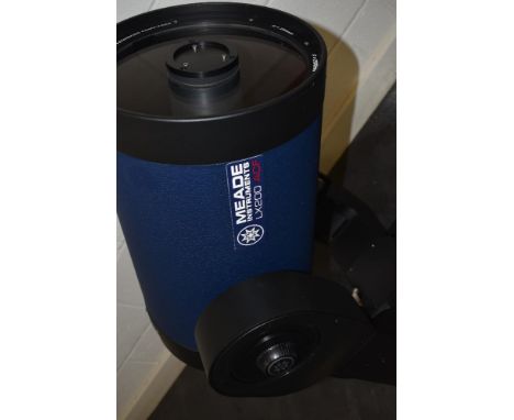
Lot 815
A Meade LX200 twelve inch ACF telescope in a Peli 0550 case with a Meade X Wedge tripod, a Meade Image shift Focuser LX200, seven Tele Vue eyepieces 4.5mm, 6mm,8mm,10mm, 12mm, 2x14mm, four Tele Vue Panoptic eyepieces 2x 19mm, 24mm and 35mm. A Tele Vue 2x power mat, a Tele Vue 1.25 inches camera adaptor eyepiece. A Meade 45degree Erect Image Diagonal Prism, a Meade Plossi 9mm Illuminated eyepiece with cord, a Dew Zapper, a USB to RS 232 Bridge cable. Explore Scientific 1,25' CLS Filter 1,25' O-111 Filter, and a 1,25' UHC Filter, an 11.63 Solar Filter, a Philips Planisphere. A Revlation Astro Mirror diagonal, an Orion Starshoot Image system with polarizing filter, Redbeam ii LED flashlight, Orion Expansion Filter, Stargazer Filter set and a Vixon flip mirror in a Peli 0550 hard case Condition Report. Very Good Condition. We do not test for functionallity, but all of this collection appears to have been very well cared for. No Dust of Fungis in glass or eyepieces

Lot 334
ANTIQUARIAN SCIENTIFIC BOOKS to include William Sturgeon - 'Lectures on Electricity delivered in The Royal Victoria Gallery, Manchester' 1842, 'Address delivered before The British Association assembled at Belfast' with additions by John Tyndall 1874, 'The First Principles of Mechanics with Historical and Practical Illustrations' by William Whewell, M. A. 1832, 'A Record of The Scientific Wotk of Sir James Dewar' 1933, Ltd. Ed. 55/200, 'The World In Its Workshops' by James Ward, pub. by William S. Orr, 'Pneumatics For The Use of Beginners' by Charles Tomlinson, 3rd ed. 1858-9, 'The Treasury of Science, Natural and Physical by Frederich Schoedler, translated by Henry Medlock, and 'The Pocket Planisphere' by Francis Chichester (8)
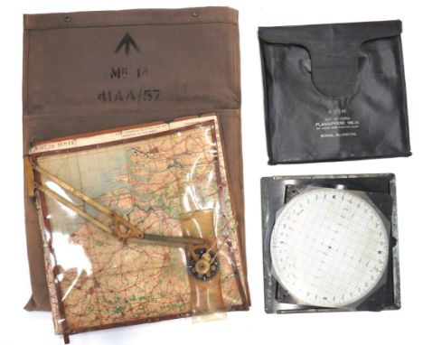
Lot 555
RAF Air Ministry Navigator’s Wooden Map Board18 x 18 inch, wooden board. The front with hinged perspex cover and adjustable, brass arm with lower directional protractor. Rear of board with “AM” stamp with code “41AA/65”. Canvas pencil holder complete with pens. Together with linen backed paper map “Strait of Dover”. Perspex with some damage. Complete in grey canvas transit bag. Together with an RAF “Planisphere MK1A”. Complete in case.
![* World. Bohun (Edmund). [Untitled map of the world], published Charles Brome, [1693], hand coloured engraved hemispheral map](https://cdn.globalauctionplatform.com/84f8dfe8-0b9b-4223-bde0-abf400abcb81/8e8133f0-08e4-4e45-b985-abf40101805a/468x382.jpg)
Lot 192
* World. Bohun (Edmund). [Untitled map of the world], published Charles Brome, [1693], hand coloured engraved hemispheral map of the world, found on the title page of Bohun's 'Geographical Dictionary', 70 x 120 mm, mounted, framed and glazed, together with: Moll (Herman). The World in Planisphere, [1695 or later], uncoloured engraved hemispheral map of the world with a smaller hemisphere of a north polar projection above, with a printed title above the map 'Geography: or a particular Description of all the known parts of the earth', map size, 165 x 190 mm, mountedQty: (2)
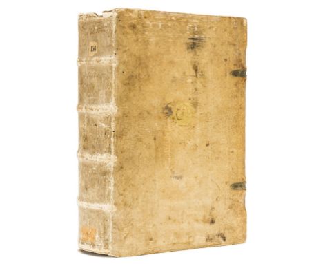
Lot 104
Schoener (Johann) Opera mathematica, 3 parts in 1, first edition, collation: α6, β4, A-Z6, Aa-Cc6, Dd-Ee8, Ff-Mm6, Nn8; a-h6, i8, including errata, colophon and final blank leaf, but lacking 2 other blanks, Roman and Greek type, title printed in red and black with two large woodcut ornaments, woodcut printer's device at end, woodcut portrait of the author on β4v, numerous woodcuts and diagrams, 4 full-page woodcuts, including terrestrial globe, celestial globe and planisphere, complete with eleven diagrams with working volvelles (some with original threads, others sometime replaced), woodcut initials, generally very fine, wide-margined copy, title gutter reinforced, quire R lightly browned, few other leaves toned, small wear to lower blank margin of b3v, tiny wormhole in blank outer margin of last several leaves, contemporary blind-tooled pigskin over wooden boards, covers within two blind-stamped rolls, outer roll dated 1541 and depicting the Crucifixion, David, the Resurrection, and St. John, inner roll dated 1556 and showing Lucretia, Caritas, and Justicia, later stamp of Schola Altenburgensis printed in gold in centre of upper cover and in black on lower cover, some minor abrasion to binding, spine slightly chipped at head, corners lightly rubbed, folio (306 x 201mm.), Nuremberg, J. Montanus & U. Neuber, 1551.⁂ Rare and important work with a most distinguished provenance, in excellent condition and in its strictly contemporary binding. The Honeyman copy of the first edition of the collected works by Johann Schöner, mathematician, astronomer, cartographer, and scientific instrument maker from Karlstadt, in Bavaria. Schöner was a contemporary of Nicolaus Copernicus and in 1526 he became the first professor of mathematics at the University of Nuremberg. His most illustrious pupil was Georg Joachim Rheticus, who in the Narratio prima (1540) announced Copernicus' discoveries. Schöner was also active as a printer and even set up a press in his house, printing numerous previously unpublished works by Johannes Regiomontanus, as well as the first printed terrestrial globe to name the recently discovered continent of America. The Opera mathematica was published posthumously by his son Andreas and is introduced by a preface by the outstanding humanist and reformer Philipp Melanchthon (1497-1560). The volume contains a representative sample of Schöner's wide and diverse interests, and a digest of some of his separately published works, most of which are extremely rare. Part 3 contains the most important section, which describes and illustrates eleven instruments, under the title Aequatorium Astronomicum, ex quo errantium stellarum motus, luminarium configurationes, & defectus colliguntur, a revised and enlarged version of the work which first appeared in 1521. The Aequatorium Astronomicum contains the earliest collection of printed equatoria-diagrams, as well as a catalogue of stars adapted by Schöner from that published by Copernicus in his De revolutionibus of 1543. The text is illustrated by an elaborate series of volvelles (movable wheel charts) used to determine planetary positions. Each part of these volvelles was printed on a separate page, such that the reader could cut them out or trace them on separate pieces of paper, and then assemble the various parts with string. These fragile 'paper instruments', which Schöner was among the first to employ, are frequently lacking or only partially present in most other copies of this work, and they are very often constructed incorrectly. This copy is exceptionally complete and includes all the volvelles, some still with their original thread. Provenance: from the library of the Latin school in Altenburg, Germany (stamp on the binding 'Biblioth. Schol. Altenburgensis'); the English politician and book collector Sir Robert Leicester Harmsworth (1870-1937; his sale at Sotheby's London, 9 February 1953, lot 9605); Robert Honeyman IV (1897- 1987; see The Honeyman Collection of Scientific Books and Manuscripts. Volume vii. Printed Books S-Z and Addenda, Sotheby's New York, 19-20 May 1981, lot 2802A); Astronomy & Science Books from The Library of Martin C. Gutzwiller, lot 175. Literature: Adams S-678, 685; VD16 S-3465; Alden 551/35; BEA, pp. 1027-1028; Houzeau - Lancaster 2388; Sabin 77806.

![[Frances Rolleston] Mazzaroth; or The Constellations in four parts, Published Rivington 1862-1865 with Mizraim; or Astronomy](https://cdn.globalauctionplatform.com/1feae78c-a0a6-474e-bb50-ab2900b470ba/8f53e19f-778f-4f09-86d1-ab2c010f9d84/468x382.jpg)
Lot 244
[Frances Rolleston] Mazzaroth; or The Constellations in four parts, Published Rivington 1862-1865 with Mizraim; or Astronomy Of Egypt containing a folding Planisphere of Dendera, the whole bound as one volume in full contemporary leather with raised bands & gilt title [Parts 1 & 2 are inscribed from the Authoress on title pages]

Lot 714
STAMPS - AN ALL-WORLD COLLECTION in a 19th century Justin Lallier leather-bound album (upper cover detached), signed to the title page verso, with hand-coloured folding planisphere, the contents including a GB QV 1d black, lettered SC, three-margin example (closely cropped lower left), with a red Maltese cross cancellation; and a U.S. printed patriotic cover, 1868.


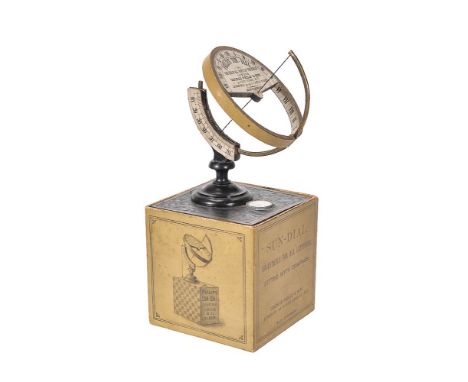
Lot 2
ϒ A German ebony brass and card universal equinoctial sundial, made for George Philip & Son, London and Liverpool, early 20th century.For latitudes 0-76 degrees North with brass ring segment resting within a groove cut into an arc applied with paper latitude scale calibrated in degrees with every ten numbered, across the diameter of the ring is a steel wire gnomon which passes though the centre of the circular hour plate set perpendicular to the brass ring, the plate applied with paper Roman numeral twenty-four hour chapter ring reading I-XII twice with the lower section cut away allowing the hour scale to continue around the inner rim of the aperture, the central infill panel inscribed PHILIPS’ SUN-DIAL, FOR USE IN ALL PARTS OF THE WORLD, LONDON, GEORGE PHILIP & SON., 32 FLEET STREET. E. C.. LIVERPOOL: 45-51, S. CASTLE STREET., MADE IN GERMANY, raised on turned ebony ogee shaped foot over a square base inset with a small glazed compass annotated with an eight-point rose, the card box also forming a plinth onto which the instrument can stand printed with DIRECTIONS FOR USE to interior, the exterior with repeat maker’s title panel, a TABLE, FOR CORRECTING SOLAR TO CIVIL TIME, an image of the sundial, and an advert of PHILIPS’ REVOLVING PLANISPHERE, the box 10cm (4in) square. George Philip and Son opened their London premises at 32 Fleet Street, London, in 1856 from where they sold their geographical and educational publications. They would later also occupy the premises next door at numbers 31 and 30 Fleet Street. In 1859, the company took over an extensive pile known as Caxton Buildings in South John Street, Liverpool, which became the company's headquarters in the city. Through the use of new power-driven printing machinery George Philips and Son became largest publishers of cartography and geographical works in the Country, as well as specialising in producing globes and planispheres for educational use. Over the years George Philips and Son Ltd took over the production lines of other firms including Malby (active 1845-1860), Betts (active 1844-1875), Smith (active 1799-1888) and Johnston (1802-1871); and in 1984 celebrated their 150th year anniversary. The company was sold in 1989 and later became part of the Octopus Publishing Group. ϒ Indicates that this lot may be subject to CITES regulations when exported. Please see our Terms & Conditions for more information.
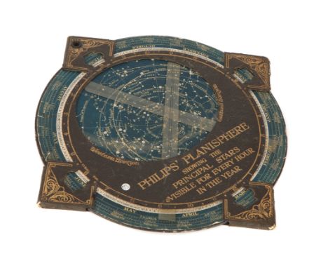

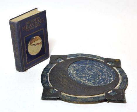
Lot 136
A Perspex Double Diamond Advertising Clock. The battery operated clock approx 35 x 27 cms together with Phillip's Planisphere' Revolving Astronomical Chart. The chart showing East and West Horizons and the principal stars visible for every day in the year together with a bronze plaque of a Spitfire quoting Sir Winston Churchill's words 'Never have so many owed so much to so few' and a bronze plaque from the Newport Golf and Country Club dated 30th June 1862, quoting 'Gentlemen players are requested to only wash their balls in the sinks provided and not elsewhere'. (3)


Lot 15
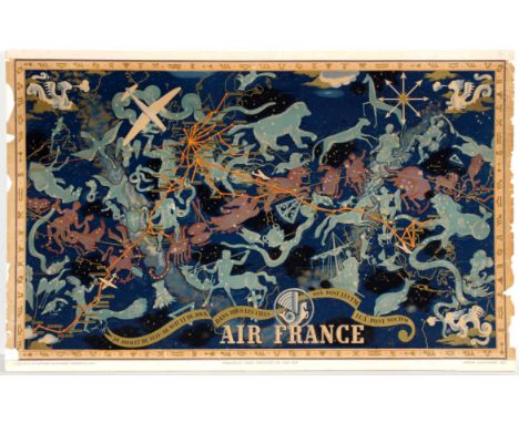
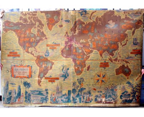
Original vintage planisphere travel advertising poster featuring a detailed illustrated Air France worldwide airline network map / Air France Reseau Aerien Mondial designed by the notable artist Lucien Boucher (1889-1971) showing the airline routes across the world decorated with sea gods, sailing ships, cruise liners and planes with landscape features and mountains, buildings, animals and people from around the world on the continents, the main cities and countries marked in banners with colourful compass points and cherubs blowing in wind on each side, the title text in a banner below and the Air France Pegasus logo above. Horizontal. Printed in France by Perceval, Paris. Fair condition, restored loss on margin, folds and tears, staining, backed on linen. Country: France, 1937, design by Lucien Boucher, size (cm): 64x100.5
Lot 20
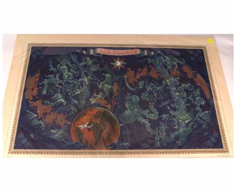
Air France Night Sky Constellation poster. Lucien Boucher produced a number of pieces for Air France in the early 20th century which were advertisments for the global coverage and glamour of air travel at the time. This version, from 1938, combines a subtle outline map with key places with a celestial planisphere that shows the various signs of the zodiac. The suggestion is of fantasy and the experience you’ll have flying. It’s designed clearly to capture the imagination and provide a strong brand message.Original vintage travel poster. Poor condition, minor creases, tears and paper losses. Backed on foam board. Country: France Year: 1938 Designer: Lucien Boucher Size: 99x62cm
Lot 49
Rare large original vintage planisphere poster map of Air France routes issued only to Air France offices. The poster features a detailed illustrated Air France worldwide airline network map / Air France Reseau Aerien Mondial designed by the notable artist Lucien Boucher (1889-1971) showing the airline routes across the world decorated with sea gods, sailing ships, cruise liners and planes with landscape features and mountains, buildings, pictures of animals and people from around the world on the margins and on the map, and the Air France Pegasus logo above. Poor condition, trimmed on all sides, losses, tears and cuts, backed on old linen, France, 1950s, size (cm): 305x204.
Lot 924
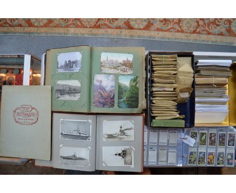
A good collection of vintage postcards including humour, military, novelty, greetings, topography, warships, etc., to/w a quantity of cigarette and other trade cards, including Wills, Rothmans, Carreras, Savory, Gallaher, Players, Millhoff, Ogdens, Cepes, Godrey Phillips, Churchman, Cavanders, Sunripe, etc., in albums and boxes, Rothmans portfolio of Rex Whistler cartoons 1950, Francis Chichester Planisphere, two Royal souvenir programmes and Post Office savings bank
Lot 155
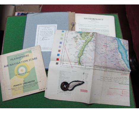
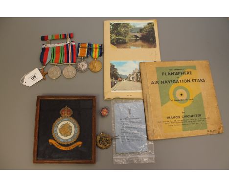
A First and Second World War medal group comprising WWI British War medal and Victory medal (both named to R. E. Pickering , R.A., and also a WWII 1939 - 45 Star, a Defence medal and War medal. Also included in the lot is An Air Ministry M.O.233 booklet "Cloud Forms According to the International Classification", a copy of Francis Chichester's "The Observer's Planisphere of Air Navigation Stars, a Royal Air Force blue membership card for E.B. Pickering, 1946, a framed embroidery badge "Transport Command Royal Air Force - Ferio Ferendo", an R.A.F. cap badge and an enamelled R.A.A. blazer badge. (Q)
Lot 115
Celestial Charts. Senex (John), A Scheme of the Solar System with the Orbits of the Planets and Comets belonging thereto, described by Dr. Halley's accurate table of Comets..., founded on Sr. Isaac Newton's wonderful discoveries, by Wm. Whiston M. A., published John Bowles & Carington Bowles, circa 1720, uncoloured engraved chart, very slight fraying to margins, 690 x 615 mm, together with The Planisphere, Stellarum Fixarum Hemisphaerium Boreale..., Stellarum Fixarum Hemisphaerium Boreale The Northern hemisphere projected on the plane of the Aequator, Stellarum Fixarum hemisphaerium Australe the Southern hemisphere projected..., Stellarum Fixarum Hemisphaerium, Australe in plano eclipticae depictum..., Zodiacus Stellatus fixas omnes hactenus cognitas as quas lunae appulsus ullibi, Terrarum Telescopio observari poterunt complexus and an untitled circular zodiacal projection, together another eight double page uncoloured engraved celestial charts, one chart trimmed with slight loss to title, occasional marginal fraying and dust soiling, each approximately 690 x 615 mm (9)
Lot 339
A rare limited edition domestic scale replica of the Bluewater Planisphere timepiece John Smith and Sons, Derby, to a design by Eric Kuhne and Associates, 1999 The mains-driven electric movement with 15 inch circular dial incorporating rotating silver on blue celestial projection disc annotated with the principal heavenly bodies and constellations set behind fixed elliptical mask revealing a simulation of the visible night sky for a given time of the year, the outer margin of the rotating celestial disc annotated with the months of the year with divisions for each day allowing the date to be read via a triangular pointer at six o clock, the outer margin with fixed silver on white narrow Arabic numeral chapter ring with dot minute markers, with canted mask and chrome finish moon hands set within stainless steel circular surround applied with engraved metal plate inscribed Bluewater, 16th March 1999, Designed by Eric Kuhne Associates, Manufactured by John Smith & Sons Derby, England, Limited Edition : 1 of 15 to lower edge, the rear with time and calendar adjustment screws, 43.5cm (17ins) diameter overall; with original packaging. The current lot is a domestic scale slightly simplified version of the large public timepiece supplied by John Smith & Sons, Derby for the Bluewater Shopping Centre, Greenhithe, Kent, installed on the 16th March 1999.

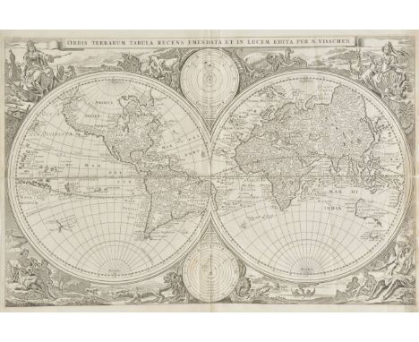
Lot 156
World. Visscher (Nicholas J.), Orbis Terrarum Tabula Recens Emendata et in Lucem Edita per N.Visscher, published Amsterdam, [1663 or later], uncoloured engraved map on a hemispheral projection, insular California, some fraying to right hand vertical margin with slight loss, old folds and some creasing, 310 x 470 mm, together with Moll (Herman), A New Map of the World according to the New Observations, circa 1710, hand coloured engraved map on a hemispheral projection, insular California, 180 x 280 mm, with Bonne (Rigobert), L'Ancien Monde et le Nouveau en deux Hemispheres [and] Planisphere suivant la Projection de Mercator, circa 1780, two engraved map with sparse outline colouring, the first map with old folds and slight spotting, 220 x 415 mm, the second map with very slight spotting, 225 x 335 mm The first described map. R.W.Shirley. The Mapping of the World, no.431, state 1. (4)
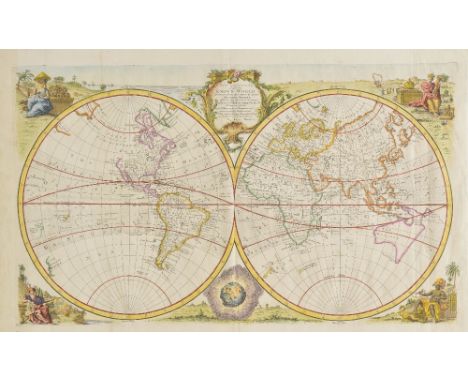
Lot 410
World ( ). Bowen (Emanuel), A New and Accurate Map of the Known World, drawn from the latest and most authentic surveys..., circa 1780, hand coloured engraved map on a hemispheral projection, old folds, 390 x 540 mm, together with Kitchin (Thomas),A New Map of the World drawn from the latest and best authorities, circa 1750, hand coloured engraved map on a hemispheral projection, old folds, 275 x 540 mm, with Bonne (Rigobert),L'Ancien Monde et Le Nouveau en deux hemispheres, circa 1780, hand coloured engraved map 230 x 420 mm, plus Bonne (Rigobert),Planisphere suivant la Projection de Mercator, circa 1780,hand coloured engraved map, 210 x 330 mm, and Tirion (I.), Nieuwe Wereld Kaart waar in de reizen van deb Hr. Anson Rondsom de Wereld, circa 1760, hand coloured engraved map on a Mercator projection, 230 x 405 mm (5)
-
186 item(s)/page