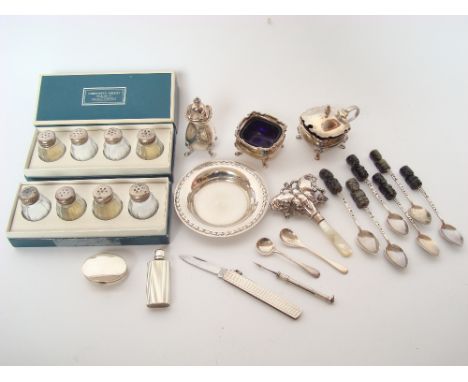
A mixed lot of silver comprising a modern silver three piece cruet set, Birmingham, 1965 by Elkington & Co Ltd, a set of six Mexican Taxco sterling silver coffee spoons with carved hardstone Mayan style figure terminals, a 900 silver pin dish, two boxed sets of four Cristofle silver mounted glass pepperettes and salt shakers, a silver pill box, engine turned scent flask, cigar piercer and an a/f silver butterfly baby rattle (approx 187.5g weighable).
We found 559 price guide item(s) matching your search
There are 559 lots that match your search criteria. Subscribe now to get instant access to the full price guide service.
Click here to subscribe- List
- Grid
-
559 item(s)/page
A South American gilt and hardstone pendant and bead necklace, the necklace with alternating rondel beads of red jasper, dark green agate and white crystal, punctuated by wire twist metal spacers, the central pendant a gilt metal figure, perhaps of a Mayan or Inca god with a condor's beak; slide clasp with safety catch, clasp and pendant stamped '24K GP'; length of necklace 44cm, of pendant 5.9cm
Mexico, California and Texas This is the first state of this fine steel-engraved map. The outline for the original state borders of Texas is shown extending into Colorado with much of present-day New Mexico included, although on this particular example the colorist traced the border along the Arkansas and Mississippi rivers, creating a peculiar configuration of the Lone Star state. Two vignettes depict Mexican peasants and the ancient Mayan ruins at Uxmal. The very decorative border incorporates native plants of the region. The map was drawn and engraved by John Rapkin, the vignettes by H. Warren and engraved by J. Rogers. Original outline color with minor toning along the centerfold. 10"" W x 13"" H Tallis, John 1850
A Map of the Bay of Campechy [with related text] This is a scarce map of the Bay of Campeche and the Yucatan Peninsula. It covers the region first explored in 1517 by Fernando de Cordoba and Antonio de Alaminos and visited by Dampier twice prior to his circumnavigations. The city of Campeche, on the west coast of the Yucatan Peninsula, derives its name from the Mayan city of Kan pech. The Sacrificious I. (Island of Sacrifices), located just offshore from Veracruz, notes the location of a prominent Aztec temple discovered by the Spanish in 1518. There are no place names along the coastline now known as Riviera Maya, but Cozumel Island is named and the city of Valladolid is located. Included is 132 pp. of related text (4.8 x 7.5""). William Dampier (1652-1715) was a soldier, buccaneer, pirate, British navy captain and hydrographer. He was also among the most influential of travel writers. Dampier completed his first circumnavigation between 1679 and 1691, during which he was among the first group of Englishmen to land in New Holland (Australia). A strong impression with a few faint spots in the image and a narrow left side margin as issued. Disbound text is lightly toned with scattered foxing mostly in the blank margins. 5.8"" W x 11"" H Moll, Herman 1705
Amerique Septentrionale This richly engraved map of North America shows the United States` claims into present-day Canada reflecting the Oregon boundary dispute. The Republic of Texas is shown, and Mexico`s northern border is drawn according to the Treaty of 1819 (here misprinted as 1810). Russia is in control of Alaska. The map is surrounded by beautifully engraved scenes of North and Central America including wildlife, a ship stranded in the polar sea and a Mayan temple. A nice impression with original outline color, light scattered foxing, and a few small edge tears confined to the blank margins. 11.2"" W x 17"" H Levasseur, Victor 1843
A Mayan blackware pottery bowl, circa 600-800 AD, of shallow circular form, the rim incised with a band of fish, diameter approx 15.5cm, together with a group of four Pre-Columbian pottery footed bowls, probably Colombian or Ecuadorian, one bowl interior incised with a figural mask (faults).
(lot of 2) Pre-Columbian style ceramic vases, in the classic and Peten Mayan style, the large one a tripod vase and depicting two important standing personages, perhaps reading proclamations; and the smaller depicting two important personages speaking to their fawning attendance, larger: 9"h. Provenance: From the estate of Edward Gerber
Amerique Septentrionale This richly engraved map of North America shows the United States` claims into present-day Canada reflecting the Oregon boundary dispute. The Republic of Texas is shown, and Mexico`s northern border is drawn according to the Treaty of 1819 (here misprinted as 1810). Russia is in control of Alaska. The map is surrounded by beautifully engraved scenes of North and Central America including wildlife, a ship stranded in the polar sea and a Mayan temple. Attractive color with just a few tiny, insignificant spots in the image and minor soiling in the blank margins. 11.2 W x 17 H Levasseur, Victor 1843
Mexico, California and Texas This is the second, and most desirable, state of this fine steel-engraved map that was issued during a time of great transition in the region. After gold was discovered in California, the plate was re-engraved to include a vignette of gold panning and to locate the gold regions of California which are delineated through hand coloring. Texas is shown with its original state borders that include much of present-day New Mexico and extend into Colorado. Two other vignettes show Mexican peasantry and the ancient Mayan ruins at Uxmal. The very decorative border incorporates native plants of the region. Map drawn and engraved by John Rapkin, vignettes drawn by H. Warren and engraved by J. Rogers. Original outline color with light toning along the centerfold, a few tiny spots, and minor soiling along the sheet edges. 10 W x 13 H Tallis, John 1850
Levasseur, Victor 1843 Amerique Septentrionale This richly engraved map of North America shows the United States` claims into present-day Canada reflecting the Oregon boundary dispute. The Republic of Texas is shown, and Mexico`s northern border is drawn according to the Treaty of 1819 (here misprinted as 1810). Russia is in control of Alaska. The map is surrounded by beautifully engraved scenes of North and Central America including wildlife, a ship stranded in the polar sea and a Mayan temple. 17"" W x 11.2"" H A clean, bright example with very minor toning along the sheet edges, away from map image. Remnants of hinge tape on verso.
Tallis, John 1850 Mexico, California and Texas This is the second, and most desirable, state of this fine steel-engraved map that was issued during a time of great transition in the region. After gold was discovered in California, the plate was re-engraved to include a vignette of gold panning and to locate the gold regions of California which are delineated through hand coloring. Texas is shown with its original state borders that include much of present-day New Mexico and extend into Colorado. Two other vignettes show Mexican peasantry and the ancient Mayan ruins at Uxmal. The very decorative border incorporates native plants of the region. Map drawn and engraved by John Rapkin, vignettes drawn by H. Warren and engraved by J. Rogers. 13"" W x 10"" H Light toning along the centerfold and sheet edges with a few minor spots.
Levasseur, Victor 1843 Amerique Septentrionale This richly engraved map of North America shows the United States` claims into present-day Canada reflecting the "Oregon boundary dispute". The "Republic of Texas" is shown, and Mexico`s northern border is drawn according to the Treaty of 1819 (here misprinted as 1810). Russia is in control of Alaska. The map is surrounded by beautifully engraved scenes of North and Central America including wildlife, a ship stranded in the polar sea and a Mayan temple. 17" W x 11.2" H A lovely example with marginal soiling.
Print, Juan Fuentes, Mayan Warrior Juan Fuentes (American, b. 1950) "Mayan Warrior," 2011, woodcut, pencil signed and dated lower right, titled center margin, edition 1/10, sheet: 53"h x 27"w, overall (with frame): 63"h x 37"w. Provenance: From the private collection of Jose Ramon Lerma (American, b.1930). Starting Price: $300
BOX 9-JAPANESE Yaki-Imo Shochu Makai He No Izanai Hyuganatsu Umeshu Maehwasu Chamisul Classic Mugi Shochu Maikokochi Kurokoji Imo Shochu Makai He No Izanai Chirancha Umeshu Kurokoji Shochu Maki He No Izanai Genshu Long-term Stored Soba Shochu Mayan No Tsubuyaki Long-term Stored Mugi Shochu Taiga No Itteki Long-term stored Soba Shochu Nayuta No Toki Feeney`s Crème Brulée
BOX 10-JAPANESE Long-term Stored Imo Shochu Daichi No Kouki Long-term Stored Mugi Shochu Aya Selection Long-term Stored Soba Shochu Mayan No Tsubuyaki Chamisul Miyanoyuki Junmai 2011 Mugi Shochu Maikokochi Genshu Mugi Shochu Maikokochi Yuzu Umeshu Chirancha Umeshu Miyanoyuki Daiginjo 2011 Miyanoyuki Gokujo 2011 Chamisul
A LOT OF 4 MEXICAN STERLING SILVER JEWELRYA lot of four Mexican 925 sterling silver jewelry including two bangles crafted with onyx stone inlay (each fitting wrist approx 2 3/8" width), mariner`s link bracelet (7 7/8" length x 1/2" width) and a Mayan style pendant (2 3/8" length). Total weight of 4.26ozt.
North America, Texas (Amerique Septentrionale), Levasseur, Atlas Universel Illustre, Paris, ca. 1845. 17 x 11.8”. (HC) This richly engraved map of North America shows the United States` claims into present-day Canada reflecting the Oregon boundary dispute. The Republic of Texas is shown, and Mexico`s northern border is drawn according to the Treaty of 1819 (here misprinted as 1810). Russia is in control of Alaska. The map is surrounded by beautifully engraved scenes of North and Central America including wildlife, a ship stranded in the polar sea and a Mayan temple. Original color with a small tear in the right blank margin, away from the image, and light toning in blank margins. (A)
A PAINTED POTTERY FIGURE OF A SEATED WOMAN , AMECA, A VESSEL IN THE FORM OF A DOG, COLIMA, BOTH PROTO-CLASSIC PERIOD AND A MAYAN POTTERY ANTHROPOMORPHIC WHISTLE IN THE FORM OF A MAN SEATED SIDEWAYS ON AN ANIMAL the woman holding a bowl on her left shoulder, figure 28cm h ++In generally satisfactory condition with the odd small chip of flaking. Figure with rather powdery surface

-
559 item(s)/page