We found 32776 price guide item(s) matching your search

Refine your search

Year

Filter by Price Range
  • List
  • Grid
  • 32776 item(s)
    /page

Lot 139

World. Ortelius (Abraham), Typus Orbis Terrarum, 1587 but [1592 - 1612], hand-coloured engraved map, ornate strapwork border with a medallion in each corner, large margins, slight creasing, slight staining and dust soiling but largely confined to the margins, central fold strengthened and repaired on verso, 355 x 485 mm, Latin text on versoQTY: (1)NOTE:Marcel van den Broecke. Ortelius Atlas Maps number 3. Rodney W. Shirley. The Mapping of the World number 122, plate 3 state 1.

Lot 97

East Indies. Ortelius (Abraham), Indiae Orientalis Insularumque Adiacientium Typus, Antwerp [1595 or later], hand-coloured engraved map, large strapwork cartouche, 345 x 500 mm, Latin text on versoQTY: (1)NOTE:Marcel van den Broecke. Ortelius Atlas Maps, number 166.

Lot 91

China. D'Anville (Jean Baptiste Bourguignon), Carte la plus Generale et qui Comprend La Chine, La Tartarie Chinoise et le Tibet Dressée sur leas cartes Particulieres des RR PP Jesuites, Paris, 1734 - [37], large engraved map with contemporary outline colouring and some later enhancement, large decorative cartouche and mileage scale, good margins, 495 x 705 mmQTY: (1)NOTE:The Qing Emperor Kangxi commissioned Jesuit surveyors to chart his kingdom from 1708 to 1716. The resulting maps were published as the Kangxi Atlas (1718-19), and the information contained in its woodcut maps would not be superseded for well over a century.The French cartographer Jean-Baptiste Bourguignon D'Anville (1697-1782), acquired copies of the Kangxi maps and devised his own interpretations, first printed in Jean-Baptiste Du Halde's "Description Geographique historique...de l'Empire de la Chine et de la Tartarie Chinoise". The cartouche reflects this connection, showing Emperor Kangxi seated above the strapwork borders of the title, presiding over the surveying parties, where two Jesuit priests, with an armed mounted escort, are investigating a settlement, with its houses, sheep and cattle.

Lot 131

Thomson (John & Co.). A collection of nine maps, West India Islands, West Indies, Remote British Islands, Martinico & Dominica (on one sheet), Jamaica, Guadaloupe Mariegalante etc. & Antigua (on one sheet), Porto Rico and Virgin Islands & Haiti Hispaniola or St Domingo (on one sheet), Grenada Tobago Curacao & Trinidad (on one sheet), St Christophers St Lucia and Nevis (on one sheet) [and] St Vincent & Barbadoes (on one sheet), circa 1830, together nine engraved maps with contemporary outline colouring, each with an ink library stamp affecting the printed image, heavily stained, together with Speed (John). Midle-Sex described with the most Famous Cities of London and Westminster, Thomas Bassett & Richard Chiswell [1676], hand-coloured engraved map, inset town plans of Westminster and London and inset views of St. Peters and St. Pauls, dust-soiled and stained, central fold and upper margin worn and torn with slight loss, repaired, the whole backed with later thick paper, 385 x 515 mm, with Bowen (Emanuel). Dorset Shire Divided into its Hundreds..., Carington Bowles and Robert Sayer, circa 1762, engraved map with contemporary outline colouring and some later enhancement, originally published in "The Large English Atlas", 540 x 705 mm, framed and glazed, plus Klint (Gustaf). Charta Öfver Upgående Grunden jemte Öpningarne till Saint Georges, Bristols soch Engelska Canalerne, Stockholm, 1801, uncoloured engraved sea chart of Cornwall, Devon, The Scilly Isles, Southern Ireland and the Western Approaches, 650 x 950 mm plus another six maps, including examples by or after Rapkin, Pigot, Russell, W. & A. K. Johnston, J. & C. Walker and Cary, various sizes and conditionQTY: (18)

Lot 136

World. Blaeu (Willem Janszoon), Nova Totius Terrarum Orbis Geographica ac Hydrographica Tabula auct: Guilelmo Blaeuw, Amsterdam [1635 - 58], engraved map with contemporary hand-colouring, the upper margin with allegorical representations of the planets, the lower margin with the seven wonders of the world and the vertical margins with - on the right - the four seasons and on the left, the four elements, left-hand border trimmed to the plate mark and extended, very slight creasing, 410 x 540 mm, Latin text on verso QTY: (1)NOTE:R. W. Shirley. The Mapping of the World, number 255, state 4. One of the finest and most famous world maps to appear in an atlas during the Golden Age of Dutch cartography.

Lot 129

Surrey. Bowen (Emanuel & Kitchin Thomas), Bowles's New Medium Map of Surrey, Divided into its Hundreds..., 1785, engraved map with contemporary wash colouring, 230 x 335 mm, together with Lodge (John). A New Map of Surrey from the Latest Authorities, circa 1795, uncoloured engraved map published in the "Atlas of Great Britain and Ireland", 270 x 340 mm, with Darton (William). Surrey 1819 - [22], engraved miniature map with contemporary wash colouring, 75 x 115 mm, supplied with its page of contemporary descriptive text, plus Green (William). Surrey, [1804], engraved map with contemporary outline colouring, originally published in Green's scarce "Picture of England", 140 x 90 mm, and Johnson (Thomas). Surrey, published Manchester [186]3, lithographic map with bright contemporary wash colouring, small stain to the lower margin, 160 x 230 mm, with another seven small format county maps of Surrey, with examples by or after Smith, Teesdale, Phillips, Darton & Harvey, Morden Kitchin and Owen & Bowen, various sizes, good conditionQTY: (12)

Lot 95

China. Ortelius (Abraham), Chinae olim Sinarum regionis nova descriptio, auctore Ludovico Georgio, Antwerp [1603], hand-coloured engraved map, orientated to the west, large strapwork cartouche and mileage scale, good margins, 370 x 470 mm, Latin text on versoQTY: (1)NOTE:Marcel van den Broecke. Ortelius Atlas maps, number 164. The first European map of China. The Second state, with "Les Philippinas" inserted above "Sinus Magnus".

Lot 52

Speed (John). The Theatre of the Empire of Great Britaine. Presenting an Exact Geography of the Kingdomes of England. Scotland and Ireland and the Isles adjoyning..., Thomas Bassett & Richard Chiswell, 1676 bound with The Prospect of the most Famous parts of the World, viz. Asia, Africa, Europe, America with these Empires and Kingdoms therein contained..., Thomas Bassett & Richard Chiswell, 1676, engraved armorial frontispiece and additional decorative title (detached), letterpress general title printed in red & black, part titles to books two, three and four printed in black (Wales, Scotland and Ireland) and letterpress title to 'Prospect' also printed in black, preliminary text leaves including dedication present, 'A New and Accurat Map of the World...,' erroneously bound in after the contents page of 'The Theatre', ninety-six (complete) uncoloured engraved maps (68 in the Theatre and 28 in the Prospect), several maps trimmed with slight loss to the strapwork margin, very occasional marginal closed tears and staining, lacking the maps of Berkshire, Derbyshire and Shropshire, but replaced with examples from the first edition of 1611, map of Derbyshre stained and toned, Spain torn with loss to the upper right corner, Denmark torn with small area of loss to the right hand margin, each map with descriptive text to the verso, index bound at rear, additional armorial frontispiece and decorative title trimmed to neatline and attached to recto and verso of blank leaf at front of the volume, additional title page loosely inserted, 18th-century bookplate of James Norman and old auction catalogue entry to the front pastedown, front free endpaper with ink stamp of I. Pickersgill, hinges and joints weak and cracked, rear board near-detached, 18th-century sheep, rubbed and worn, folioQTY: (1)NOTE:Chubb, XXVII. John Speed's 'Theatre' is regarded as a landmark in the history of British topography. It was the first English attempt to produce a grand scale atlas, including the first maps of the provinces of Ireland. The 'Theatre' evolved into a world atlas with the addition of the 'Prospect' in 1627. The 1676 edition of the Prospect includes seven new maps which were not present in the 1627 edition: Virginia and Maryland, New England, Carolina, Jamaica and Barbados, East India, Russia and Canaan.

Lot 107

Jamieson (Alexander). A Celestial Atlas Comprising a Systematic Display of the Heavens in a Series of Thirty Maps Illustrated by Scientific Descriptions of their Contents, and Accompanied by Catalogues of the Stars and Astronomical Exercises, G. & W. B. Whittaker, T. Cadell and N. Hailes, 1822, engraved calligraphic title and dedication, thirty (complete) engraved celestial maps and charts, twenty-nine with sparse contemporary wash colouring, each with tissue guard, some damp staining to the front third of the atlas, contemporary half morocco gilt with publisher's printed label to the upper siding, bumped and worn at extremities, oblong 4toQTY: (1)

Lot 110

London. Lewis (Samuel). [Atlas to the Topographical Dictionary of England] circa 1844, lacking title and preliminaries, uncoloured folding engraved map of England and Wales and London and 42 (only) engraved county maps, some folding, some spotting throughout, some maps detached, upper hinge broken, contemporary cloth, lacking spine, 4to, together with Tegg (T. T. & J. publishers). New Plan of London &c. with 360 references to the Principal Streets etc. circa 1832, engraved map with contemporary outline colouring, sectionalised and laid on linen, slight staining, short split along one old linen fold, 440 x 625 mm, contained in a contemporary marbled card slipcase with publisher's green & black label to the upper cover, some wear to the extremities of the slipcase, with Crutchley (G. F.). A New & Improved Map of the Environs of Windsor extending from 14 to 18 Miles round the Castle, J. B. Brown, Book & Print Seller to the Royal Family Windsor, circa 1830, engraved map with bright contemporary wash colouring, sectionalised and laid on linen, 300 x 240 mm, bound in contemporary green gilt cloth boards, plus another approximately 75 late 19th & 20th-century folding maps of London and its environs, with examples by or after Bacon, Ordnance Survey, Philips, Gall & Inglis, Smith & Son, W H Smith, "Geographia", Kelly, Bowen and Stanford, various sizes and conditionQTY: (approx. 80)NOTE:The second item described. Howgego number 295, state 8.

Lot 126

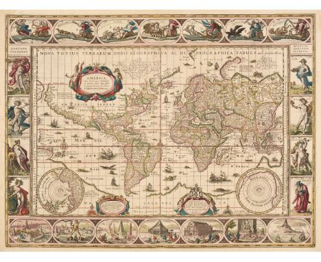
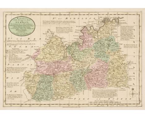
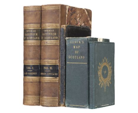
Scotland. Bartholomew (John), Black's New Large Map of Scotland compiled from the Ordnance, Admiralty & other Surveys, A & C Black, 1862, twelve colour lithographic map sheets, each sectionalised and laid on linen, very slight staining, endpapers with near-contemporary manuscript annotations, each sheet approximately 490 x 500 mm, contained in a contemporary green cloth slipcase, some wear to extremities of the case, together with Blackwood (William). Blackwood's Atlas of Scotland: Containing Twenty-Eight Separate Maps of the Counties, together with the Orkney, the Shetland and the Western Isles and a General Map of Scotland, 1847, printed title with some damp staining, folding map of Scotland and thirty engraved maps (lacking Kincardineshire), all with contemporary outline colouring, some staining and spotting throughout, hinges and joints weak and cracked, contemporary black morocco gilt 'envelope style' binding, rubbed and worn, 8vo, with Wilson (Rev. James Marius). The Imperial Gazetteer of Scotland; or Dictionary of Scottish Topography..., 2 volumes, A. Fullarton, 1854 - 57, additional decorative half-title, folding map of Scotland with handling tears, crudely repaired with sellotape on verso, 31 engraved county maps by Archibald Fullarton, all with contemporary outline colouring, 7 plans and numerous coloured topographical plates, slight staining throughout, contemporary half calf gilt with contrasting morocco gilt labels to spines, bumped and with slight wear, large 8vo, plus Philip (George & Son). Philip's Atlas of the Counties of Scotland; A Series of Twenty-Seven Maps, 1858, title page with near-contemporary ownership signature, contents list, 27 engraved county maps and a folding general map of Scotland (complete as list), contemporary blind stamped cloth with gilt title to the upper siding, some wear to extremities, small 8vo, QTY: (5)

Lot 28

Thomson (John). A New General Atlas, consisting of a series of geographical designs on various projections, exhibiting the form and component parts of the Globe; and a collection of maps and charts, delineating the natural and political divisions of the empires, kingdoms, and states in the World. Constructed from the best systematic works, and the most authentic voyages and travels. With a memoir of the progress of geography, a summary of physical geography, and a consulting index to facilitate the finding out of places, Edinburgh: Printed by George Ramsay and Company, for John Thomson and Company, Edinburgh; Baldwin, Cradock, and Joy, London; and John Cumming, Dublin, 1817, printed title with some spotting, dedication to Alexander Keith of Dunottar and Ravelston, list of maps and charts, 23 pages of introductory text and 22 pages of a consulting index, double-page comparison plate, 76 (of 74 engraved double-page and folding maps with duplicates of the maps of the Prussian Dominions and of Arabia), all with contemporary outline colouring, some off-setting and slight spotting, some staining throughout, a few maps frayed at the margins, chart of the North Atlantic Ocean with closed tear, each map with a small contemporary paper numeral pasted to the upper right corner, marbled endpapers, contemporary half morocco gilt, scarred and worn, folio (555 x 435 mm) QTY: (1)NOTE:The largest atlas published in Scotland at the time, Thomson's atlas is distinguished by its map of Europe in four sheets, the several sheets devoted to the major islands of the West Indies, as well as fine detailed maps of the Arabian peninsula, Japan and Korea, and Australia.

Lot 79

Asia. Ortelius (Abraham), Asiae Nova Descriptio, [1575 or later], engraved map with contemporary outline colouring, large strapwork cartouche, large margins, slight dust soiling to the margins, 370 x 490 mm, Latin text on versoQTY: (1)NOTE:Marcel van den Broecke. Ortelius Atlas Maps, number 7. An example of the second plate (of 2), which is distinguished by the lowercase 'f' in farfana in the top right corner, to the east of Japan, the lack of 'cum privilegio' in the lower-left corner and the disappearance of the town of Ara, to the north-west of Aden.

Lot 32

Boswell (Henry). The Antiquities of England and Wales Displayed..., new edition, with alterations and improvements, London: Alex Hogg, 1795, engraved frontispiece, 21 engraved maps only (some detached), numerous engraved plates, contemporary marbled calf, boards detached, worn, folio, together with:Wood (John George), The Principal Rivers of Wales illustrated; consisted of a series of views from the source of each river to its mouth..., part 2 only, London: Printed for the author, by T. Bensley, 1813, two hand-coloured double-page folding maps, 68 sepia soft-ground etched plates (including 27 coloured including 8 double-page), some damp staining at foot of some leaves, contemporary black half calf, gilt decorated spine, joints split and with old repairs, folio, and Newbery & Carnan (Publishers), A description of England and Wales containing a particular account of each county, volumes 2-4 & 6-10 only, London, 1769-70, numerous engraved plates, wood engraved vignette illustrations, contemporary calf, maroon morocco title label to spine of each, wear to extremities, 12mo, and a folding hand-coloured engraved map of England & Wales by J. & C. Walker, circa 1840, sectionalised on linen, heavily varnish to printed surface, plus Bacon's "Excelsior" Memory-Map Atlas, 1906QTY: (12)

Lot 31

Bacon (G. W. publisher). Bacon's Large Scale Atlas of London and Suburbs..., with an Alphabetical Index..., circa 1930s, title and contents list, contents page with long closed repaired tear, 7 lithographic double-page county maps, 25 maps of London, index maps and 34 sheet map of London, publisher's half morocco, worn and rubbed, hinges and joints weak and cracked with the upper board near detached, folio, together with Commercial and Library Atlas of the World with Index-Gazetteer, circa 1890, additional half-title, title page with some spotting, preface and index, frontispiece of 'The Flags of all Nations' and 100 colour lithographic maps and diagrams, slight dust soiling, index bound at rear, later endpapers, modern half morocco but retaining the contemporary boards, slight staining to the sidings, folio QTY: (2)

Lot 71

Vintage model railway. Selection of incomplete and compete 0 gauge carriages and trucks with accessories. Vintage complete and incomplete locos, a collection of corgi and Atlas coaches, collection of complete / incomplete lead diecast figures, military and parade, Airfix aircraft kits x 4 , unused and ERTL apache and other vintage cars and toys .Conditions varied, please see pictures supplied.( 2 boxes)

Lot 662

Gilded figure of Atlas holding a globe, on wooden plinth, H27cm

Lot 781

A quantity of boxed Atlas Editions aeroplanes, including B-17 Flying Fortress, Douglas A-26 Invader, Vickers Wellington, and several boxed diecast vehicles, including Corgi Dad's Army model no. 09002 etc

Lot 743

A quantity of Vintage toys, including various miniature instruments in hard cases, an Atlas Editions Elvis Presley Acoustic Guitar, various badges, a hand-built metal cannon, an American postal box, a Vintage Donald Duck wooden puppet, miniature commemorative Coca-Cola bottles etc

Lot 59

"The Army List of the Roundheads and Cavaliers" by Peacock 1863, spine leather bound; "The General History of the Late War: Containing its Rise, Progress and Event in Europe, Asia, Africa and America"….Volume 1, by the Rev John Entick, 3rd edition, 1766; "The Numismatic Atlas of the Roman Empire" by Peter Whelan (this is a chart of Roman Emperors and Empresses with line drawings of their coin portraits in order of reign and not a map); "Rank and Badges in Her Majesty's Army and Navy" by Perry 1887. £40-60

Lot 239

A massive Egyptian Government atlas of Egypt, comprising a series of maps and diagrams with description text illustrating the orography, geology, meteorology and economic conditions, presented to the International Geographical Congress at Cambridge 1928 by command of His Majesty King Fouad I, 71 x 85.5cm.

Lot 52

Atlas Editions - The Sport of Kings Race Horse model statues, Man o' War; Desert Orchid; Mill Reef; Shergar, all in original unopened and sealed boxes, 2012/2013. Qty: 4

Lot 304

ATLAS EDITIONS COLLECTIONS from DeAgostini 'small scale models for adult collectors', ships, 22, all in original packaging

Lot 95

MIXED LOOSE EPNS CUTLERY & COLLECTABLES GROUP - cutlery includes five large tablespoons in A1 plate by Collis & Co, 6 large dinner forks and five table forks, fiddle pattern by Thomas Prime & Sons, pair of ribbed handle bright cut fish servers, ETC, collectables include twelve Lesney Products, British Inns cast metal standing signs, 1970s dates and three boxed mini trains 1/220 from Editions Atlas Collections, two still sealed

Lot 319

Bailieres Popular Atlas of the Anatomy and Physiology of the female human body; and another

Lot 166

Dinky Toys - Three boxed Dinky Toy model vehicles. Lot consists of Dinky Toys #430 Commer Breakdown with windows (restrung breakdown hook); #436 Atlas Copco Compressor Lorry; and #158 Rolls Royce Silver Shadow. Models all exhibit play and age wear with some paint nicks and chips. Overall conditions appear Fair Plus - Good. Models housed in boxes with some general storage and age wear appearing Fair - Good overall. (This does not constitute a guarantee)

Lot 212

Corgi - Hot Wheels - Matchbox - Solido - Others - A large unboxed group of playworn and plasti diecast vehicles in various scales. Lot includes Tonka Bulldozer; Matchbox Super Kings K15 Merryweather Fire Engine; Hot Wheels Hammer Head; Corgi Major Holmes Wrecker; Solido Citroen 2CV, a vintage transformer with two controllers (Atlas Editions box is EMPTY) and similar. Models all have varying degrees of play wear ranging Poor - Fair and are unchecked for completeness. (This does not constitute a guarantee)

Lot 361

Altaya, Atlas Editions - 9 x boxed and postage-boxed die-cast model aircraft planes - Lot includes an Atlas Editions Focke-Wulf FW 190A-5 and North American Mustang P-51D with stands and is presented in polystyrene Atlas Editions box. An Atlas Editions 'Battle of Britain 1940' Messerschmitt Bf 109E-4. An Altaya Petlyakov PE.8. An Altaya Kawanishi N1K2 -J Shidenkai, and similar. Most die-cast models appear part built with accessories. Unchecked for completeness. Die-cast models appear mint in boxes with most boxes having pen annotations to the back of box.. (This does not constitute a guarantee)

Lot 362

Atlas Editions - 8 x die-cast Atlas Editions model aircraft planes - Lot includes a #4 646 103 Heinkel He 111 with outer sleeve. A #4 646 108 FW 200 'Condor'. A two set 'War in the Pacific' Vought F4U Corsair, and Mitsubishi A6M3 Zero set, and similar. Some die-cast models appear part built with accessories. All die-cast models come with stands. Unchecked for completeness. Most boxes are missing outer sleeve. Die-cast models are presented in Atlas Editions polystyrene boxes. Die-cast models appear in excellent condition. (This does not constitute a guarantee)

Lot 363

Atlas Editions - 8 x die-cast Atlas Editions model aircraft planes - Lot includes a #4 646 112 Handley Page Hampden. A #4 646 101 Avro Lancaster 'Dambuster'. A #4 646 130 Liore et Olivier LeO 45. A #4 646 122 Lockhead Hudson, and similar. Most die-cast models appear part built with accessories. All die-cast models come with stands. Unchecked for completeness. Most boxes have outer sleeves. Die-cast models are presented in Atlas Editions polystyrene boxes. Die-cast models appear in excellent condition. (This does not constitute a guarantee)

Lot 368

Atlas Editions, Oxford Aviation - 3 x 1:72 scale boxed and 2 x polystyrene boxed die-cast model planes - Lot includes an Oxford 1:72 #72PP001 Percival Proctor MK V G-Akiu Classic Air Force. A 1:72 Oxford Aviation #AC039 Nakajima KI-43. A 1:72 Oxford Aviation #AC037 Fiat G55. An Atlas Editions Bristol Beaufort. An Atlas Editions Cant Z-1007bis Alcione. Atlas Editions die-cast models are part built and come with accessories. Unchecked for completeness. Die-cast models appear in excellent condition as well as boxes. (This doe snot constitute a guarantee)

Lot 156

A box of cameras and binoculars. Includes Nikon Coolpix3100 boxed camera, Panasonic Lumix TZ5 boxed camera, Kodak Retinette IB camera, Atlas binoculars, etc.

Lot 93

Four modern Atlas Edition collectors eggs having original boxes.

Lot 169

A MAP OF ASIA (1880) Propetto politico dell'Asia designed by Ermanno Berghau, from Stieler Atlas n. 38 Published in Verona by Gotha: Giusto Perthes 44cm x 41cm (framed) Condition: Good condition considerate age and use, old colours, some foxing consistent with age

Lot 171

A FRENCH MAP OF ASIA (1860) Year: 1860 Publisher: Charles Delagrave, Paris Description: a map from Atlas Universel originally drawn by Brue in 1831 and updated by Levasseur , both very well known French cartographers. See the foothold of Saigon in Vietnam obtained by France in 1859. Singapore is clearly marked . Framing: in a champagne-colour wooden frame 40cm x 57cm Condition: Map restored, central fold as issued

Lot 478

MARVEL WESTERN LOT (3 in Lot) - Includes MARVEL WESTERNS HARDCOVER BOOK (2006) + WILD WESTERN #23 (1952 - ATLAS) + BLACK RIDER #24 (1954 - ATLAS) - Flat/Unfolded

Lot 479

RAWHIDE KID #1 (1955 - ATLAS) - The first appearance of the Rawhide Kid (the first version of the character) - Cover art by Joe Maneely - Flat/Unfolded - a photographic condition report is available on request

Lot 480

WESTERN THRILLERS #2 & 3 (2 in Lot) - (1954/1955 - ATLAS) - "Swivel-Gun Snide Strikes!" & "Two-Gun Showdown at Black Rock!" - Cover art by Joe Maneely & Russ Heath - Flat/Unfolded

Lot 481

RINGO KID WESTERN #1 (1954 - ATLAS) - Includes Cover art by Joe Maneely - Flat/Unfolded - a detailed photographic condition report is available on request

Lot 482

RINGO KID WESTERN #3 & 14 (2 in Lot) - (1954/1956 - ATLAS) - Joe Maneely cover art - Flat/Unfolded - a detailed photographic condition report is available on request

Lot 483

TWO-GUN KID #11, 15, 16, 41, 48 (5 in Lot) - (1953/1959 - ATLAS) Includes cover art by Syd Shores, Chuck Miller, Joe Maneely & Jack Kirby - Flat/Unfolded

Lot 484

WYATT EARP #4, 7, 24, 26 (4 in Lot) - (1956/1959 - ATLAS) - "Robbers of the Rio Rapids!", "The Mysterious Bandit", "Captured by the Apaches!", "The Durfees take Over Dodge City!" - Cover art by Joe Maneely, Russ Manning & Dick Ayers - Flat/Unfolded - a detailed photographic condition report is available on request

Lot 485

TEXAS KID #3, 5, 7 (1951/1952 - ATLAS) - With cover art by Joe Maneely - Flat/Unfolded

Lot 1502

A box of mixed scale public transport buses, to include Atlas Editions

Lot 1510

Two boxes of mixed modern issue diecast, to include Atlas Edition and Corgi Classics

Lot 1174

RAF and aircraft collectors plates, books and an Atlas Editions model aircraft **PLEASE NOTE THIS LOT IS NOT ELIGIBLE FOR POSTING AND PACKING**

Lot 2315

Three gents watches including boxed Daniel Hechter for Atlas and two pedometer watches.

Lot 332

Foy, Maximilien Atlas - Histoire de la Guerre de la Péninsule sous Napoléon Prédédée d'un Tableau politique et militaire des Puissances belligérantes. Atlas. Paris, Baudouin Frères 1827. 7 Kupferstiche, darunter Portrait des Generals nach Horace Vernet, drei Karten und drei Schlachtenpläne. Lex. 8° HLdr. - Ein Plan lose, Einband etwas bestoßen, Papier leicht fleckig. - Maximilien-Sébastien, comte Foy war ein französischer General und Staatsmann und Kommandeur Napoleons.antiquarisches Buch, Kriegsführung

Lot 4082

Eddie Stobart trucks, loose, no boxes, Eddie Stobart boxed plates (17) together with Atlas Collection of boxed Motor Cycles (15) (qty)

Lot 1338

Atlas China Early XX Century Tea Service, of approximately fifty pieces, with rose pattern, including tea pot:- One Tray

Lot 397

Bacons "Large Excelsior Atlas of the World" and The Times Atlas (loosely bound)

Lot 55

FOUR BOUND VOLUMES OF THE ATLAS NEWSPAPER, 1829-1832

Lot 328

Lapérouse (Jean-François de Galaup, comte) Voyage de La Pérouse Autour du Monde, 5 vol. including Atlas, first edition, half-titles, engraved portrait frontispiece, Atlas with engraved title, portrait frontispiece and 69 maps and plates, many double-page or folding, tissue-guards, text with ink stamp of Domus Lugdunensis Soc. Jesu to titles, vol. 1 with ink inscription "ex dono Radactoris" to pastedown, dated Paris 1821, occasional light spotting, Atlas with bookplate of Frederick E. Ellis, some dust-soiling to extremities, upper hinge weak but holding, all vol. uncut in original decorative boards, printed paper labels to spines, wear to extremities, particularly spine ends and joints, with some chipping to paper, text with small paper label with manuscript shelfmark to spine foot, Atlas a little darkened and with label worn, upper joint split and repaired at head, preserved in 3 morocco-backed drop-back boxes, [Sabin 38960; Hill 972; Ferguson 251], 4to & folio, Paris, 1797.⁂ An impressive set of one of the finest narratives of maritime exploration, covering Easter Island, Hawaii, Macao, Formosa, the Aleutian Islands, Samoa, Tonga and Australia.

Lot 420

Demidoff (Anatole de) Voyage dans la Russie Méridionale et la Crimée, atlas vol. only, half-title, 88 engraved plates and maps only (of 95), most hand-coloured, tissue-guards, scattered spotting and browning, ?ex-library with remnants of ink-stamp and ink numbers to title, small hole to title, cracked hinges, contemporary calf-backed boards, bumping to corners and spine extremities, folio, Paris, 1842.

Lot 323

Krusenstern (Capt. Ivan Fedorovich) Voyage Autour du Monde, Fait dans les Années 1803, 1804, 1805 et 1806, 3 vol. including the rare Atlas, first French edition, half-titles, Atlas with 21 lithographed plates and 9 engraved maps (3 folding), tissue-guards, vol. 1 with contemporary ink ownership inscription to title, text lightly browned and with a few instances of marginalia in red pencil, some light scattered foxing or spotting, uniformly bound in later calf-backed marbled boards, spines gilt with morocco labels, very lightly rubbed, Atlas spine a little sunned, an attractive set, [Sabin 38332; Hill 953], 8vo & folio, Paris, 1821.⁂ The first French edition of Krusenstern's circumnavigation, thought to be translated from the original Russian by the author. This is the only edition to include the Atlas, "very important and difficult to obtain" (Hill).

Lot 381

Puzzle Atlas.- Boxed set of eight jigsaw puzzle maps of the world, engraved maps with hand-colouring, laid down to wood and resting upon supporting card layer (loose), recent brown ribbon tags, a few pieces with chips or discretely replaced, together housed within original decorative paper-covered box with embossed lid, paper label of original retailer to lid underside, slight crack to lid, some toning, rubbed and worn, each map c.285 x 380mm., Paris, [late nineteenth century]

Lot 286

Arago (Jacques) Promenade Autour du Monde, 3 vol. including Atlas, first edition, half-titles, Atlas with engraved map and 25 lithographed plates, bookplate of Carl Wendell Carlsmith to front free endpapers, scattered foxing, Atlas with portion of marginal damp-staining throughout, modern half calf, spines gilt but a little sunned, Atlas in later boards with printed paper label to spine, rubbed at spine ends and corners, uncut, text partly unopened, [Hill 28; Ferguson 850], 8vo & folio, Paris, 1822.⁂ A personal and sometimes eccentric narrative of the Freycinet circumnavigation by the voyage's official artist, written in the form of letters to a friend. Extensive portions relate to Australia, with descriptions of Sydney and the Blue Mountains. The plates largely depict individuals encountered during the voyage.

Lot 387

Japan.- Montanus (Arnoldus) Atlas Japannensis: being Remarkable Addresses by way of Embassy... to the Emperor of China, translated by John Ogilby, first English edition, large paper copy, engraved additional pictorial title, 24 double-page engraved plates and 69 illustrations in text, letterpress title in red and black (a little soiled), lacking map of Japan, some damp-staining towards end, a few small, neat repairs, bookplates of John Leveson Gower, 1st Earl Gower to title verso and of Gower Earl Gower, Richard Ponsonby-Fane and Strathallan to front pastedown, contemporary panelled calf, gilt arms of the Order of the Garter to upper cover, neatly rebacked, retaining original backstrip, rubbed, [Wing M2485], folio (440 x 320mm.), by Tho. Johnson, 1670.

Lot 295

Australasia.- Péron (François) and Louis-Claude de Saulces de Freycinet. Voyage de Découvertes aux Terres Australes, 5 vol. including Atlas, second edition, half-titles, engraved portrait after C.A. Lesueur, errata leaf, Atlas with 9 engraved maps or plans, 1 double-page, and 60 engraved plates by N. Petit or C.A. Lesueur on 59 sheets, 2 double-page, 27 hand-coloured, a few partly printed in colours, double-page plates neatly mounted on stubs, 1 with vertical tear expertly repaired, some light foxing and the odd small stain, a few coloured plates slightly browned, uniform 19th century calf-backed marbled boards, spines gilt, lightly rubbed, Atlas with short split to upper joint at foot, [Ferguson 978-79; Nissen ZBI 3120; Wantrup 82], 8vo & 4to, Paris, 1824.⁂ An attractive set of the scarce revised edition of the account of the expedition to the Pacific, first published in 1807-16, with corrections and 25 plates not found in the first edition. The Atlas includes the first detailed chart of the entire Australian continent, views (including 2 of Sydney, one folding), coastal profiles, artefacts, natural history and ethnographic subjects.

Lot 294

Australasia.- Péron (François) and Louis-Claude de Saulces de Freycinet. Voyage de Dècouvertes aux Terres Australes, a complete set of 6 parts in 5 vol., first edition, half-titles, engraved portrait frontispiece, 2 folding tables, Atlas Historique with engraved vignette title, 40 plates, 2 folding and 23 hand-coloured, 14 maps, 2 folding, with folding plates and maps neatly mounted on stubs, Atlas Hydrographie with engraved vignette title, contents leaf and 32 maps, many double-page, with all ff. on stubs, 1 folding map with small hole and repair to central fold, another plate with small repair to blank lower margin, some light foxing and occasional slight browning, plates still generally crisp and bright, uniform modern calf-backed boards, spines gilt with morocco labels, a handsome set, 4to & folio, Imprimerie Impériale [Royale], 1807-16.⁂ The great French voyage of the Napoleonic period to the "terres Australes" or southern continent under captain Baudin, chronicled by its participants Louis de Freycinet (later to command his own voyage) and the scientist François Péron, and published in six separate parts over a period of nearly ten years.

Loading...Loading...
  • 32776 item(s)
    /page

Recently Viewed Lots