Filtered by:
- Category,
- Item Type
- List
- Grid
A subscription to the Price Guide is required to view results for auctions ten days or older. Click here for more information
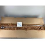

A Tudor lead crystal old English yard of ale glass, in original box and packaging
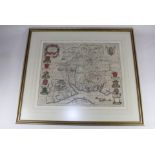
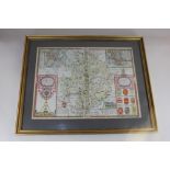
A framed 17th century Johannes Blaeu engraved map of Hampshire, Hantonia Sive Sovthantonensis
A framed 17th century Johannes Blaeu engraved map of Hampshire, Hantonia Sive Sovthantonensis Comitatvs Vulgo Hant-Shire, certificate of authentic...
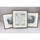
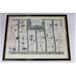
A John Ogilby strip map of the road from Salisbury to Gloucester, 34cm by 45cm
A 17th century Gerard Mercator engraved map of South East England, 'Warwicum, Northamtonia, Huntingdonia, Cantabrigia, Suffolcia, Oxonium, Bucking...
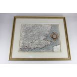
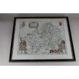
A John Speed map of Warwickshire 'The Counti of Warwick the shire towne and citie of Coventry',
A John Speed map of Warwickshire 'The Counti of Warwick the shire towne and citie of Coventry', inset town plans of Warwick and Coventry, with Eng...
A Johannes Blaeu map of Worcester, Warwickshire and Coventry, 'Wigoriensis', with text verso, in
A Johannes Blaeu map of Worcester, Warwickshire and Coventry, 'Wigoriensis', with text verso, in double glazed frame, 50cm by 59cm (a/f - glass cr...

A framed 19th century style portrait of a Naval sea captain, 32.5cm by 27cm
Warwickshire interest, two 19th century prints after J Brandard, a view of Kenilworth Castle, 21cm
Warwickshire interest, two 19th century prints after J Brandard, a view of Kenilworth Castle, 21cm by 26cm, and Warwick Castle, 19cm by 23cm, toge...
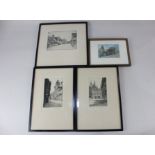
20th century school, three views of West Wycombe, St Paul's Cathedral, and The Law Courts, etchings,
20th century school, three views of West Wycombe, St Paul's Cathedral, and The Law Courts, etchings, inscribed and indistinctly signed in pencil, ...
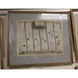
A 17th century John Ogilby strip road map, The Road from Gloucester to Coventry, From Gloucester
A 17th century John Ogilby strip road map, The Road from Gloucester to Coventry, From Gloucester to Cheltenham to Winchcombe to Campden to Stratfo...