Refine your search
Sale Section
- Antiquarian (55)
- Art Reference & Photography (17)
- Bookbinding Tools & Accessories (75)
- British Topography (19)
- Decorative Prints (48)
- General Literature (39)
- General Stock (47)
- Historical Documents & Ephemera (23)
- Library Furniture (1)
- Maps (117)
- Natural History & Herbals (26)
- Travel & Exploration (42)
Estimate
Category
- Books & Periodicals (234)
- Maps (118)
- Prints (66)
- Collectables (16)
- Salvage & Architectural Antiques (14)
- Furniture (12)
- Arms, Armour & Militaria (7)
- Classic Cars, Motorcycles & Automobilia (6)
- Stamps (6)
- Watercolours (6)
- Tools (4)
- Coins (3)
- Kitchenalia (2)
- Metalware (2)
- Sculpture (2)
- Textiles (2)
- Bank notes (1)
- Drawings & Pastels (1)
- Glassware (1)
- Models, Toys, Dolls & Games (1)
- Oil, Acrylic paintings & Mixed Media (1)
- Photographs (1)
- Taxidermy & Natural History (1)
- Vintage Fashion (1)
- Writing Instruments (1)
- List
- Grid
A subscription to the Price Guide is required to view results for auctions ten days or older. Click here for more information


Yates (Major G. & Rennie Sir John). A View of Old London Bridge in 1823, after the Removal of the Water Works, 1823, publisher's printed paper wra...
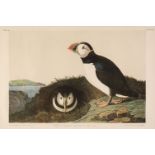
Audubon (John James, 1785-1851). Puffin. Mormon Arcticus, plate 454, chromolithograph, published by Julius Bien, New York, 1860, 40 x 55.5 cm, fra...
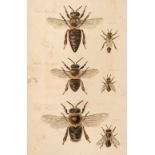
Bagster (Samuel). The Management of Bees. With a Description of the "Ladies Safety Hive.", 1st edition, London: Samuel Bagster & William Pickering...
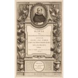
Barrelier (Jacques). Plantae per Galliam, Hispaniam et Italiam observatae, 1st edition, Paris: Stephan Ganeau, 1714, [16], 8, 140, xxvi, [2pp]., 2...
Bewick & Ruskin. Bewick Gleanings: Being Impressions from Copperplates and Wood Blocks, Engraved in the Bewick Workshop... , Edited, with Notes, b...
Buffon (Georges Louis Leclerc). Natural History, General and Particular, 2nd edition in English, 9 volumes, London: W. Strahan and T. Cadell, 1785...
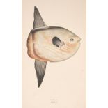
Couch (Jonathan). A History of the Fishes of the British Islands, volumes I-II & V only (of 4), London: Groombridge and Sons, 1862-65, 193 colour ...
Dodens (Rembert). Mechliniensis Medici Caesari Stirpium Historiae Pemptades Sex Sive Libri XXX, Antwerp: Balthasarem et Ioannem Moretos 1616, [8],...
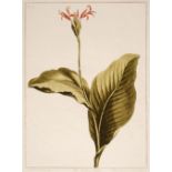
Edwards, Sydenham Teast (1768-1819), Botanical Plates: Convolvulus Major; The Indian Reed; Cabbage province Rose, published 1788, three etchings w...
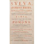
Evelyn, John. Sylva, Or, A Discourse of Forest-trees, and the propagation of timber in His Majesty's Dominions ..., Terra, A Philosophical Essay o...
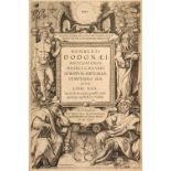
![Gerard (John). [The Herball or Generall Historie of Plantes..., 1636]](https://portal-images.azureedge.net/auctions-2022/srdom10199/images/c29ab6a7-cad2-4f71-9fb1-aecc011ac2ac.jpg?w=155&h=155)
Gerard (John). [The Herball or Generall Historie of Plantes. Gathered by John Gerarde of London Master in Chirurgerie: very much enlarged and amen...
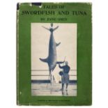
Grey (Zane). Tales of Swordfish and Tuna, 1st edition, New York and London: Harper & Brothers, 1927, code 'H-B' to title verso, half-tone illustra...
Haller (Albrecht von). Historia Stirpium Indigenarum Helvetiae Inchoata, 3 volumes bound in one, 1st edition, Berne: Societatis Typographicae, 176...
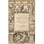
L'Ecluse (Charles de). Clusius, Carolus. Exoticorum libri decem: quibus animalium, plantarum, aromatum, aliorumq?ue peregrinorum fructuum historia...
L'Ecluse (Charles de). Clusius, Carolus. Rariorum plantarum historia, Antwerp: Plantin and J. Moretus, 1601, [12], 364, cccxlviii, 12pp., engraved...
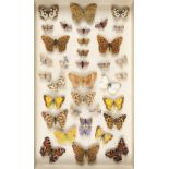
Lepidoptera. A collection of mostly British (and North American) butterflies and moths, presented in 6 glazed display cabinets, a total of approxi...
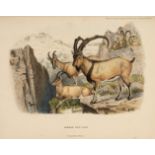
Lydekker (Richard). Wild Oxen, Sheep and Goats of All Lands Living and Extinct, 1st edition, London: Rowland Ward, 1898, 28 hand-coloured lithogra...
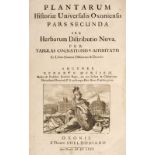
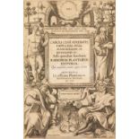
Morison (Robert). Plantarum Historiae Universalis Oxoniensis, volumes 2 & 3 [all published], Oxford: Theatro Sheldoniano, 1680-99, 293 engraved pl...
![Prevost (Florent). Histoire Naturelle des Oiseaux D'Europe, Paris: F. Savy, [1864]](https://portal-images.azureedge.net/auctions-2022/srdom10199/images/17dbe497-2488-427a-af0a-aecc011ac8c7.jpg?w=155&h=155)
Prevost (Florent). Histoire Naturelle des Oiseaux D'Europe, Paris: F. Savy, [1864], additional illustrated title, 80 hand-coloured plates, two fur...

Ray (John). Miscellaneous Discourses concerning the Dissolution and Changes of the World..., 1st edition, Samuel Smith, 1692, imprimatur leaf, a l...
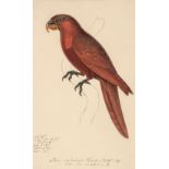
Reichenbach (Heinrich Gottlieb Ludwig, 1793-1879). 'Lori Cardinal Hombr. Faigt. Voy.', (i.e Cardinal lory parrot), watercolour and pencil on paper...
Salmon (William). Botanologia. The English Herbal: or, History of Plants, 1st edition, [London: I. Dawkes for H. Rhodes & J. Taylor, 1710], additi...

Sibbald (Robert). Scotia Illustrata, sive Prodromus Historiae Naturalis, 3 parts in 1, Edinburgh: Jacobi Kniblo, Josuae Solingensis & Johannis Col...
Sowerby (James & Smith, James Edward). English Botany; or, coloured figures of British plants, with their essential characters, synonyms, and plac...
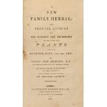
Thornton (Robert John). A New Family Herbal: or Popular Account of the Natures and Properties
Thornton (Robert John). A New Family Herbal: or Popular Account of the Natures and Properties of the various Plants used in Medicine, Diet, and th...
Timaeus von Güldenklee (Balthasar). Casus medicinales praxi triginta sex annorum observati, accessere et Medicamentorum singularium quae in casibu...
[Worlidge, John]. Systema Agriculturae; The Mystery of Husbandry Discovered... and Dictionarium Rusticum: or, The Interpretation of Rustick Terms,...
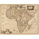
Africa. Dapper (Olfert), Africae Accurata Tabula ex Officina Jacobum Meursium [1686 or later], map with contemporary outline colouring, engraved b...

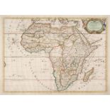
Africa. Ortelius (Abraham), Africae Tabula Nova, 1570 - 1612, hand-coloured double-page map, engraved by Frans Hogenberg, large strapwork cartouch...
Africa. Sanson (Nicolas), Afrique Par N. Sanson Geographe ordinaire du Roy..., Pierre Mariette,
Africa. Sanson (Nicolas), Afrique Par N. Sanson Geographe ordinaire du Roy..., Paris, Pierre Mariette, 1669, hand-coloured engraved map, decorativ...
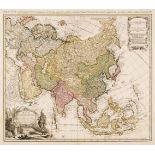
Asia. Homann (Johann Baptist, heirs of), Asia secundum legitimas Projectionis Stereographicae..., 1744, engraved map with contemporary outline col...
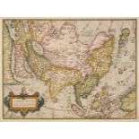
Asia. Ortelius (Abraham), Asiae Nova Descriptio, Antwerp [1570 -75], hand-coloured engraved map, large strapwork cartouche, 370 x 490 mm, Latin te...
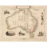
Australia. Rapkin (J.), Set of seven maps of Australasia: Australia, Victoria or Port Phillip, Western Australia Swan River, New South Wales, Part...
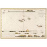
Azores. Depot de la Marine (publisher), Carte Réduite des îles Açores dressée Par Ordre du Ministre de la Marine Pour le Service des Vaisseux Fran...
Bertius (Pieter & Ortelius Abraham). Abraham Ortelii Geographiae veteris Tabulae Aliquot. Europa, Hispania, Britannia, Gallia Strabonis, Belgium, ...
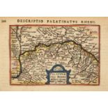
Bertius (Pieter). A collection of 18 maps of France & Germany, circa 1600, engraved maps with near-contemporary hand-colouring, each approximately...
* Betts (John). Betts’s Tour Through England & Wales, [and Tour through Europe), circa 1875 [and
Betts (John). Betts’s Tour Through England & Wales, London: George Philip & Son, and Liverpool: Philip, Son and Nephew, circa 1875, hand-coloured ...
Blaeu (Joannes). Four county maps, Darbiensis Comitatus vernacule Darbie Shire, Comitatus Dorcestria sive Dorsettia vulgo Anglice Dorset Shire, He...
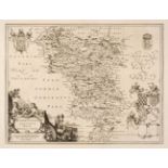
Blaeu (Johannes). Glocestria Ducatus vulgo Glocestershire, Amsterdam, circa 1648, engraved map with bright contemporary hand-colouring, 415 x 500 ...
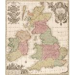
British County Maps. A collection of 80 maps, 16th - 19th century, engraved county maps, road maps and maps of the British Isles, including Magini...
British County Maps. A collection of approximately 100 maps, 17th - 19th century, engraved and lithographic county maps, road maps and town plans,...
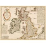
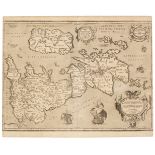
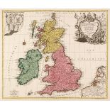
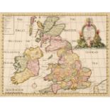
British Isles. Boisseau (Jean). Carte generalle de la Grande Bretagne jadis Albion et du Royaume d'Irlande ou Hybernie avec les Isles circonuoisin...
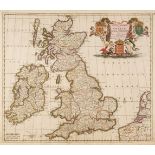
British Isles. Danckerts (Justus). Novissima et Accuratissima Totius Angliae Scotiae..., 1690
British Isles. Danckerts (Justus). Novissima et Accuratissima Totius Angliae Scotiae et Hiberniae Tabula..., Amsterdam, circa 1690, engraved map w...
British Isles. Doncker (Hendrick), Pas-caart van 't Canaal, vertoonende in 't geheel Engelandt, Schotlandt, Yrlandt, en een gedeelte van Vranckrij...
* British Isles. Jansson (Jan & Hondius Henricus), Magnae Britanniae et Hiberniae Tabula, 1631
British Isles. Jansson (Jan & Hondius Henricus), Magnae Britanniae et Hiberniae Tabula, 1631 [or later], hand-coloured engraved map, inset map of ...
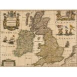
British Isles. Jansson (Jan & Ortelius Abraham), Insularum Britannicarum Acurata Delineatio ex Geographicis Conatibus Abrahami Ortelii, Amsterdam,...
British Isles. Lotter (Tobias Conrad), La Grande Bretagne ou Les Royaumes D'Angleterre et D'Ecosse comme aussi le Royaume D'Irlande Divisée par Pr...
British Isles. Seutter (Matthaus), Tabula Novissima Accuratissima Regnorum Angliae, Scotiae, Hiberniae..., Augsburg, circa 1736, engraved map with...
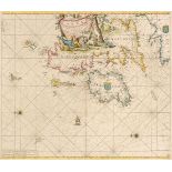
British Isles. Van Keulen (Johannes), Paskaart van 't Canaal Engelandt Schotlandt en Yrland, 1708
British Isles. Van Keulen (Johannes), Paskaart van 't Canaal Engelandt Schotlandt en Yrland..., , circa 1708, hand-coloured engraved sea chart ori...
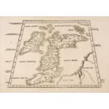
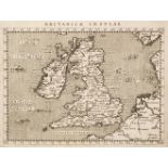
British Isles. Waldseemuller (Martin), Untitled map of the British Isles, Melchior & Gaspar Treschel, Lyons [1535], uncoloured woodblock map on a ...
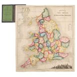
British Isles. Wells (Edward), A New Map of the British Isles, Shewing their Present Genl. Divisions, Cities and such other Towns or Places..., ci...
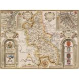
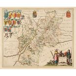
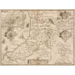
Buckinghamshire. Speed (John), Buckingham Both Shyre and Shire Towne describ. Roger Rea [1662], hand-coloured engraved map, inset town plans of Bu...
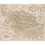
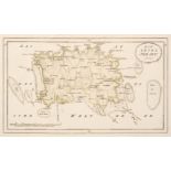
Cambridge & Huntingdonshire. A collection of 20 maps, 17th - 19th century, engraved and lithographic maps, many with contemporary hand-colouring, ...
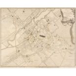
Canterbury. Andrews (J. & Wren M.), A Plan of the City of Canterbury Survey'd, A. Dury & W. Herbert, 1768, uncoloured engraved city plan, old fold...
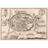
Canterbury. Braun (Georg & Hogenberg Franz), Cantuarbury, Jan Jansson circa 1657, uncoloured engraved city plan, originally published in Jansson's...
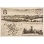
Canterbury. Hollar (Wenceslaus), The North Prospect of Canterbury [on sheet with] The Ground Plot of Canterbury & A Prospect of the Southside of C...
Cardiganshire. Speed (John), Cardigan Shire Described with the due forme of the Shiretown, 1662
Cardiganshire. Speed (John), Cardigan Shire Described with the due forme of the Shiretown as it was surveyed by J. S. Anno 1610, Roger Rea [1662],...
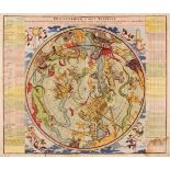
Celestial Chart. Homann (Johann Baptiste), Hemisphaerium Coeli Australe, Nuremberg, circa 1730, hand-coloured celestial chart after J. G. Doppelma...
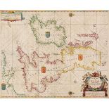
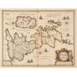
Channel Islands. Von Reilly (F. J. J.), Die Insel Jersey & Die Englaendischen Inselin..., circa
Channel Islands. Von Reilly (Franz Johann Joseph), Die Insel Jersey [and] Die Englaendischen Inselin an der Küste von Frankreich, Vienna, circa 17...
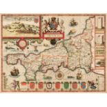
Cornwall. Speed (John), Cornwall, John Sudbury & George Humble, circa 1627, hand-coloured engraved map, inset plan of Launceston, central fold par...