Filtered by:
- Sale Section
- List
- Grid
A subscription to the Price Guide is required to view results for auctions ten days or older. Click here for more information
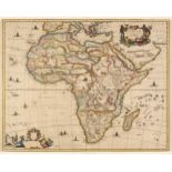

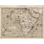
Africa. Dapper (Olfert), Africae Accurata Tabula ex Officina Jacobum Meursium [1686 or later], map with contemporary outline colouring, engraved b...

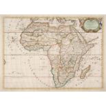
Africa. Ortelius (Abraham), Africae Tabula Nova, 1570 - 1612, hand-coloured double-page map, engraved by Frans Hogenberg, large strapwork cartouch...
Africa. Sanson (Nicolas), Afrique Par N. Sanson Geographe ordinaire du Roy..., Pierre Mariette,
Africa. Sanson (Nicolas), Afrique Par N. Sanson Geographe ordinaire du Roy..., Paris, Pierre Mariette, 1669, hand-coloured engraved map, decorativ...
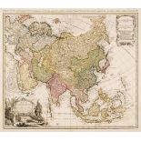
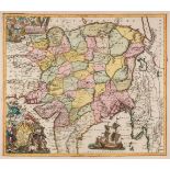
Asia. Homann (Johann Baptist, heirs of), Asia secundum legitimas Projectionis Stereographicae..., 1744, engraved map with contemporary outline col...
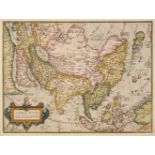
Asia. Ortelius (Abraham), Asiae Nova Descriptio, Antwerp [1570 -75], hand-coloured engraved map, large strapwork cartouche, 370 x 490 mm, Latin te...
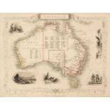
Australia. Rapkin (J.), Set of seven maps of Australasia: Australia, Victoria or Port Phillip, Western Australia Swan River, New South Wales, Part...
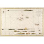
Azores. Depot de la Marine (publisher), Carte Réduite des îles Açores dressée Par Ordre du Ministre de la Marine Pour le Service des Vaisseux Fran...
Bertius (Pieter & Ortelius Abraham). Abraham Ortelii Geographiae veteris Tabulae Aliquot. Europa, Hispania, Britannia, Gallia Strabonis, Belgium, ...
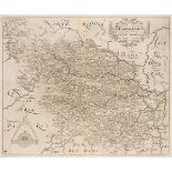
Bertius (Pieter). A collection of 18 maps of France & Germany, circa 1600, engraved maps with near-contemporary hand-colouring, each approximately...
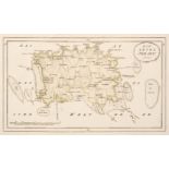
* Betts (John). Betts’s Tour Through England & Wales, [and Tour through Europe), circa 1875 [and
Betts (John). Betts’s Tour Through England & Wales, London: George Philip & Son, and Liverpool: Philip, Son and Nephew, circa 1875, hand-coloured ...
Blaeu (Joannes). Four county maps, Darbiensis Comitatus vernacule Darbie Shire, Comitatus Dorcestria sive Dorsettia vulgo Anglice Dorset Shire, He...
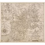
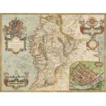
Blaeu (Johannes). Glocestria Ducatus vulgo Glocestershire, Amsterdam, circa 1648, engraved map with bright contemporary hand-colouring, 415 x 500 ...
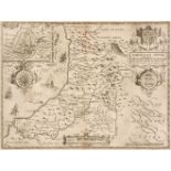
British County Maps. A collection of 80 maps, 16th - 19th century, engraved county maps, road maps and maps of the British Isles, including Magini...
British County Maps. A collection of approximately 100 maps, 17th - 19th century, engraved and lithographic county maps, road maps and town plans,...
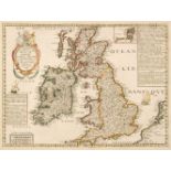
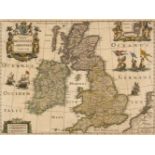
British Isles. Boisseau (Jean). Carte generalle de la Grande Bretagne jadis Albion et du Royaume d'Irlande ou Hybernie avec les Isles circonuoisin...
British Isles. Danckerts (Justus). Novissima et Accuratissima Totius Angliae Scotiae..., 1690
British Isles. Danckerts (Justus). Novissima et Accuratissima Totius Angliae Scotiae et Hiberniae Tabula..., Amsterdam, circa 1690, engraved map w...
British Isles. Doncker (Hendrick), Pas-caart van 't Canaal, vertoonende in 't geheel Engelandt, Schotlandt, Yrlandt, en een gedeelte van Vranckrij...
* British Isles. Jansson (Jan & Hondius Henricus), Magnae Britanniae et Hiberniae Tabula, 1631
British Isles. Jansson (Jan & Hondius Henricus), Magnae Britanniae et Hiberniae Tabula, 1631 [or later], hand-coloured engraved map, inset map of ...
British Isles. Jansson (Jan & Ortelius Abraham), Insularum Britannicarum Acurata Delineatio ex Geographicis Conatibus Abrahami Ortelii, Amsterdam,...
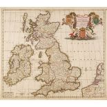
British Isles. Lotter (Tobias Conrad), La Grande Bretagne ou Les Royaumes D'Angleterre et D'Ecosse comme aussi le Royaume D'Irlande Divisée par Pr...
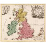
British Isles. Seutter (Matthaus), Tabula Novissima Accuratissima Regnorum Angliae, Scotiae, Hiberniae..., Augsburg, circa 1736, engraved map with...
British Isles. Van Keulen (Johannes), Paskaart van 't Canaal Engelandt Schotlandt en Yrland, 1708
British Isles. Van Keulen (Johannes), Paskaart van 't Canaal Engelandt Schotlandt en Yrland..., , circa 1708, hand-coloured engraved sea chart ori...
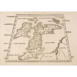
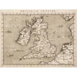
British Isles. Waldseemuller (Martin), Untitled map of the British Isles, Melchior & Gaspar Treschel, Lyons [1535], uncoloured woodblock map on a ...
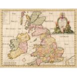
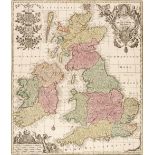
British Isles. Wells (Edward), A New Map of the British Isles, Shewing their Present Genl. Divisions, Cities and such other Towns or Places..., ci...
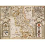
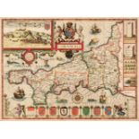
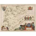
Buckinghamshire. Speed (John), Buckingham Both Shyre and Shire Towne describ. Roger Rea [1662], hand-coloured engraved map, inset town plans of Bu...
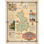
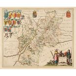
Cambridge & Huntingdonshire. A collection of 20 maps, 17th - 19th century, engraved and lithographic maps, many with contemporary hand-colouring, ...
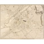
Canterbury. Andrews (J. & Wren M.), A Plan of the City of Canterbury Survey'd, A. Dury & W. Herbert, 1768, uncoloured engraved city plan, old fold...
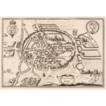
Canterbury. Braun (Georg & Hogenberg Franz), Cantuarbury, Jan Jansson circa 1657, uncoloured engraved city plan, originally published in Jansson's...
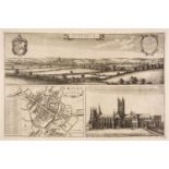
Canterbury. Hollar (Wenceslaus), The North Prospect of Canterbury [on sheet with] The Ground Plot of Canterbury & A Prospect of the Southside of C...
Cardiganshire. Speed (John), Cardigan Shire Described with the due forme of the Shiretown, 1662
Cardiganshire. Speed (John), Cardigan Shire Described with the due forme of the Shiretown as it was surveyed by J. S. Anno 1610, Roger Rea [1662],...
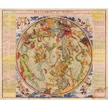
Celestial Chart. Homann (Johann Baptiste), Hemisphaerium Coeli Australe, Nuremberg, circa 1730, hand-coloured celestial chart after J. G. Doppelma...
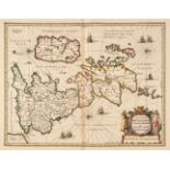
Channel Islands. Von Reilly (F. J. J.), Die Insel Jersey & Die Englaendischen Inselin..., circa
Channel Islands. Von Reilly (Franz Johann Joseph), Die Insel Jersey [and] Die Englaendischen Inselin an der Küste von Frankreich, Vienna, circa 17...
Cornwall. Speed (John), Cornwall, John Sudbury & George Humble, circa 1627, hand-coloured engraved map, inset plan of Launceston, central fold par...
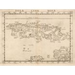
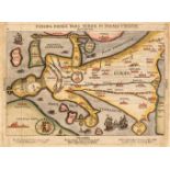
Cuba. Ruscelli (Girolamo), Isola Cuba Nova, Venice, circa 1561 uncoloured engraved map, slight toning to the central fold, 190 x 260 mm, Italian t...
Drayton (Michael). Four allegorical maps, Somerset & Wiltshire, Oxford & Buckinghamshire (2 copies) & Gloucestershire and Worcestershire [1612 - 2...
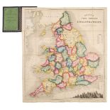
England & Wales. A collection of 60 Maps, 18th & 19th century, engraved and lithographic maps, including examples by or after Rapkin, Archer, Virt...
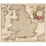
England & Wales. Allard (Carol), Regni Angliae et Walliae Principatus Tabula..., J. Covens & C. Mortier, Amsterdam, circa 1730, engraved map with ...
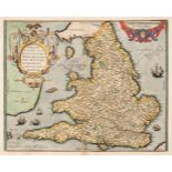
England & Wales. Ortelius (Abraham & Lhuyd Humphrey), Angliae Regni Florentissimi nova descriptio auctore Humfredo Lhuyd Denbygiense, circa 1592, ...
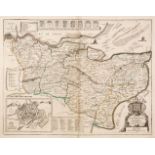
Essex. Chapman (John, and André, Peter). A Map of the County of Essex from an actual survey taken in MDCCLXXII: LXXIII & MDCCLXXIV by John Chapman...

Europe. Blaeu (Willem Janszoon), Europa recens descripta à Guilielmo Blaeuw, Amsterdam, circa 1630, engraved carte-a-figures map of Europe with te...
Europe. Bünting (Heinrich), Europa Prima pars Terrae in Forma Virginis, Magdeburg, 1581, woodcut map with contemporary hand-colouring, heightened ...
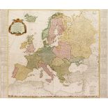
Europe. Kitchin (Thomas), A New and Accurate Map of Europe, Divided into its Empires, Kingdoms, States and Republics, Drawn by the Sieur Robert De...
Foreign Maps. A collection of approximately 220 maps, 16th - 19th century, engraved and lithographic maps including examples by or after Magini, B...
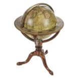
* Globe. Cary (John), Cary's New Terrestrial Globe Delineated from the best Authorities..., circa
Globe. Cary (John), Cary's New Terrestrial Globe Delineated from the best Authorities extant; Exhibiting the late Discoveries towards the North Po...
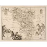
Gloucestershire, Worcestershire & Warwickshire. A collection of 28 maps, 17th - 19th century
Gloucestershire, Worcestershire & Warwickshire. A collection of 28 maps, 17th - 19th century, engraved maps, including examples by or after Smith,...
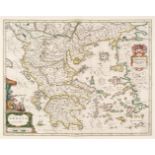
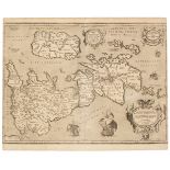
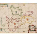
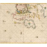
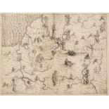
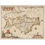
Greece. Blaeu (Johannes), Six maps of Greece, Graecia, Macedonia Epirus et Achaia, Morea olim Peloponnesus, Candia olim Creta, Cyclades Insulae in...
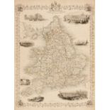
Greenwood (C. & J.). Atlas of the Counties of England made from Actual Surveys made from the years 1817 to 1833..., 2 volumes, 1834, calligraphic ...
Hampshire and the Isle of Wight. A collection of 29 maps, 17th - 19th century, engraved maps, including examples by or after, Bickham, Dower, Arch...
Hampshire. Speed (John), Hantshire described and devided, Thomas Bassett & Richard Chiswell [1676], uncoloured engraved map, inset town plan of Wi...
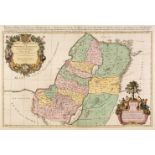
Holy Land. Jaillot (Alexis-Hubert), Judaea, seu Terra Sancta quae Hebraeorum sive Israelitarum in suas Duodecim Tribus Divisa..., G. Sanson, Amste...
India. Seutter (M.). Imperii Magni Mogolis sive Indici Padschach..., Augsburg, circa 1738, hand-coloured engraved map, large decorative cartouche ...
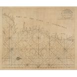
India. Thornton (John). Four sea charts of the coast of Southern India, A Large Chart of Part of the Coast of Coremandell from Point Pedro to Arme...
Indian Ocean. Bertelli (Ferrando), Seconda Ostro Tavola, Venice, circa 1565, uncoloured map engraved by Niccolo Nelli (to whom the map is sometime...
Ireland. Speed (John), The Province of Connaugh with the City of Galwaye, Thomas Bassett & Richard Chiswell [1676], hand-coloured engraved map, in...
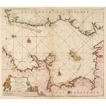
Irish Sea. Van Keulen (Johannes), Nieuwe Pas-Kaert vande Oost Kust van Yrland..., circa 1680
Irish Sea. Van Keulen (Johannes), Nieuwe Pas-Kaert vande Oost Kust van Yrland, d, Beginnende van de Hoeck van Waterfoort tot aen de Mayds, als med...
Isle of Wight. Blaeu (Johannes), Vectis Insula Anglice The Isle of Wight, Amsterdam, circa 1660
Isle of Wight. Blaeu (Johannes), Vectis Insula Anglice, The Isle of Wight, Amsterdam, circa 1660, engraved map with contemporary outline colouring...
Japan & Korea. A collection of seven maps, 18th & 19th century, including Zatta (Antonio). L'Impero del Giapon Diviso in Sette Principali Parti......
Johnston (W. & A. K.). The Royal Atlas of Modern Geography..., Edinburgh & London, 1879, frontispiece of the North Pole, additional half-title, pr...
Kent. Lea (Philip), To His Grace ... John Tillotson ... Lord Archbishop of Canterbury ... this New Map of Kent, is Most Humbly Presented and Dedic...
Leicestershire & Rutland. A collection of 20 maps, 17th - 19th century, engraved and lithographic maps, many with contemporary hand-colouring, inc...