Refine your search
Sale Section
- 16th-18th Century Literature (34)
- 19th Century Literature & Library Sets (14)
- A Fine Private Travel Library (50)
- Art Reference & Architecture (16)
- British Topography (23)
- Cookery (26)
- Decorative Prints (46)
- General Literature (11)
- Maps (46)
- Natural History (39)
- Quantity (58)
- Topographical Views: The David Smith Collection Part III (42)
- Travel & Exploration (40)
Estimate
Category
- List
- Grid
A subscription to the Price Guide is required to view results for auctions ten days or older. Click here for more information

Paxton (Joseph & Lindley, John). Paxton's Flower Garden, revised by Thomas Baines, 3 volumes, London: Cassell, Petter, Galpin & Co., 1882-84, extr...
Peregrine Press. The Meyers' Illustrations of British Birds, 2007, one of 40 deluxe copies, &
Peregrine Books. The Meyers' Illustrations of British Birds. By W. G. Hale, 1st edition, [London & Leeds]: Maggs Bros. and Peregrine Books, 2007, ...
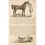
Roberts (James). The Sportsman's Pocket Companion: Being a Striking Likeness or Portraiture of the most Eminent Race Horses and Stallions that eve...
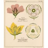
Rohweder (Joachim). Blütendiagramme nebst Längsschnittbildern von ausgewählten einheimischen Blütenpflanzen als vertretern der hauptabteilungen de...
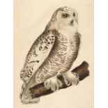
* Selby (Prideaux John, 1788-1867). Snowy Owl, Plate XXIII from Illustrations of British Ornithology, published 1826-43, hand-coloured engraving o...
Sowerby (James). English Botany; or, Coloured Figures of British Plants, with their essential characters, synonyms, and places of growth. By Sir J...
Tegetmeier (William B.). Pigeons: their Structure, Varieties, Habits, and Management, 1868, 16 chromoxylographic plates (including frontispiece), ...

Warner (Robert). Select Orchidaceous Plants. The Notes on Culture by B. S. Williams ... assisted by some of the Best Growers [First Series], 10 or...
[Worlidge, John]. Dictionarium Rusticum & Urbanicum: or, a Dictionary of all Sorts of Country Affairs, Handicraft, Trading, and Merchandizing. Con...

Ackermann (Rudolph, publisher). A History of the University of Oxford, Its Colleges, Halls and Public Buildings, 2 volumes, 1st edition, printed f...

Atkyns (Robert). The Ancient and Present State of Glocestershire, 2nd edition, London: Reprinted by T. Spilsbury for W. Herbert, 1768, eight singl...

Bristol. Picturesque Old Bristol. A Series of Fifty-Two Etchings by Charles Bird, 2 volumes, 1885
Bristol - Bird (Charles). Picturesque Old Bristol. A Series of Fifty-Two Etchings by Charles Bird, with Letterpress by John Taylor, 2 volumes, Bri...

Bristol. The New Bristol Directory, for the Year, 1792..., by John Reed, Bristol: Wm. Browne,
Bristol. The New Bristol Directory, for the Year, 1792..., by John Reed, Bristol: Wm. Browne, Wm. Bulgin, et al., [1792], pp. [4],84, scattered sp...

Bulmer (W. & Co. publisher). Picturesque Representations of the Dress..., of the English, 1814
Bulmer (W. & Co. publisher). Picturesque Representations of the Dress and Manners of the English. Illustrated in Fifty Coloured Engravings with De...

Camden (William). Britannia: or a Chorographical Description of Great Britain and Ireland, together with the Adjacent islands..., 2 volumes, secon...

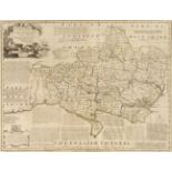
Cary (John). Cary's New and Correct English Atlas: Being a New Set of County Maps from Actual Surveys..., 1st edition, London: John Cary, Septr. 1...

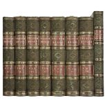
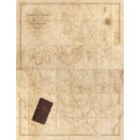
Hoare (Richard Colt). The History of Modern Wiltshire, 14 volumes in 11, 1822-1844, hand-coloured engraved maps, numerous engraved plates and plan...

Lewis (Samuel). Atlas to the Topographical Dictionaries of England and Wales..., 1848 title with later pencil marginalia, folding engraved map of ...

Macaulay (Kenneth). The History of St. Kilda, London: T. Becket & P.A. De Hondt, 1764, half-title, folding engraved map frontispiece, endpapers re...

Macaulay (Kenneth). The History of St. Kilda, containing a Description of this remarkable Island; the Manners and Customs of the Inhabitants; the ...

Marshall (William). The Rural Economy of Gloucestershire; Including its Dairy: Together with the Dairy Management of North Wiltshire: and the Mana...

Moule (Thomas). The English Counties Delineated; or a Topographical Description of England. Illustrated by a Map of London and a complete series o...
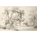
* Nicholson (George, 1795?-1838). Views in the vicinity of Liverpool, 1832, a sketchbook comprising 17 pencil drawings of buildings and landscapes...

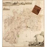
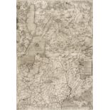
Owen (John & Bowen, Emanuel). Britannia Depicta or Ogilby Improv'd; Being a Correct Coppy of Mr. Ogilby's Actual Survey of all ye Direct & Princip...

Robertson (Archibald). Topographical Survey of the Great Road from London to Bath and Bristol, 1792
Robertson (Archibald). A Topographical Survey of the Great Road from London to Bath and Bristol, 2 parts in one, London: Printed for the Author, 1...

Rudder (Samuel). A New History of Gloucestershire, 1st edition, Cirencester: Samuel Rudder, 1779
Rudder (Samuel). A New History of Gloucestershire, 1st edition, Cirencester: Printed by Samuel Rudder, 1779, 26 engraved plates (comprising 4 doub...

Scott (Walter). The Border Antiquities of England and Scotland; comprising Specimens of Architecture and Sculpture, and other Vestiges of Former A...

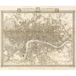
Shepherd (Thomas). Metropolitan Improvements; or London in the Nineteenth Century ... with Historical, Topographical, and Critical Illustrations b...

Thompson (Pishey). The History and Antiquities of Boston, and the Villages of Skirbeck, Fishtoft, Freiston, Butterwick, Benington, Leverton, Leake...

Thoresby (Ralph). Ducatus Leodiensis: Or, the Topography of the ... Town and Parish of Leedes, 1715
Thoresby (Ralph). Ducatus Leodiensis: Or, the Topography of the Ancient and Populous Town and Parish of Leedes, and Parts Adjacent in the West-Rid...

Walker (J & C, publishers). Hobson's Fox-Hunting Atlas; containing separate Maps of every county in England and the three Ridings of Yorkshire...,...

Wallis (James, publisher). New pocket ... English counties or Travellers companion, circa 1810
Wallis (James, publisher). Wallis's New Pocket Edition of the English Counties or Travellers Companion, London: J. Wallis, circa 1810, engraved ti...
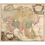
Asia. Homann (Johann Baptist), Asiae Recentissima Delineatio qua Status et Imperia Totius Orientis Unacum Orientalibus Indiis Exhibentur, Nurember...
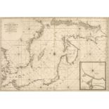
* Baltic Sea. Jaillot (Alexis Hubert), Carte de la Mer Baltique Contenant les Bancs, Isles et Costes Comprises entre l'Isle de Zelande et l'Extrem...
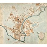
Bath. Hancock (Robert, 1730/31-1817). A New and Accurate Plan of the City of Bath to the Present Year, Bath, A. Taylor and W. Meyler, 1795, hand-c...
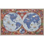
Boucher (Lucien, 1889 - 1971). Air France. Sur les Ailes d'Air France Decouvrez le Monde a Votre Tour, printed by Perceval, Paris, circa 1950, col...
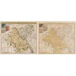
Bowen (Emanuel). An Accurate Map of Dorsetshire divided into Hundreds. Drawn from the best authorities..., An Accurate Map of Cambridgeshire divid...
British maps. A mixed collection of approximately 175 country, county, regional, road and railways maps and town plans, 18th & 19th century, engra...
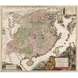
China. Seutter (George Matthaus), Opulentissimum Sinarum Imperium..., Augsburg, circa 1740, engraved map with contemporary hand colouring and some...
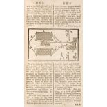
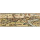
* Danzig/Gdansk. Wolff (Johann Peter), Dantzig, circa 1730, engraving with contemporary hand colouring, key below image identifying 42 locations, ...
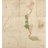
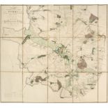
Epping Forest. Plan of Waste Lands in the Northern Portion of Epping Forest in the County of Essex [and] Plan of Waste Lands in the Southern Porti...
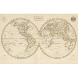
Ewing (Thomas). Ewing's New General Atlas; containing Distinct Maps of all the Principal States and Kingdoms throughout the World; A New edition i...
Folding Maps. A collection of fourteen maps, atlases and guide books, mostly 19th century, including Bowen (Emanuel). An Accurate Map of the Count...
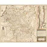
Forest of Dean. Atkinson (John), Plan of Her Majesty's Forest of Dean, in the County of Gloucestershire, with High Meadow and Great Doward Woods b...
Gloucestershire. Taylor (Isaac), To the Subscribers in General and more Particularly to those Noblemen and Gentlemen who honoured me with their As...
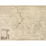
Leicestershire. Bowen (Emanuel), An Accurate Map of the Counties of Leicester and Rutland divided into their respective Hundreds..., R. Sayer & Ca...
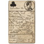
Leicestershire. Morden (Robert), Lecester Sh: Playing card map, circa 1676, uncoloured engraved 'playing card map' with the suit mark of clubs and...
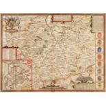
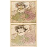
* Leicestershire. Speed (John), Leicester both Countye and Citie described, The Honorable Famylies that have had the titles of Earls thereof. With...
* Lithuania. Hondius (Henricus). Magni Ducatus Lithuaniae..., Amsterdam, circa 1640, engraved map with contemporary outline colouring, inset map o...
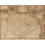
* Norfolk. Speed (John), Norfolk a Countie florishing & populous described and devided with the armes of such noble familes as have borne the titl...
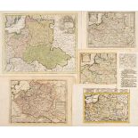
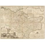
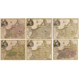
Poland. A collection of ten maps, 18th century, ten hand-coloured engraved maps, including Weigel (Christopher). Poloniae & Lithuania accurante cu...
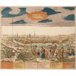
* Poland. Braun (Georg & Hogenberg Franz). Cracovia Metropolis Regni Poloniae, Cologne, [1617 or later], hand coloured large engraved city panoram...
* Poland. Cluver (Philip), Prussiae Nova Tabula, Amsterdam, circa 1697 - 1729, hand coloured map, engraved by John Harris, with another five versi...
* Poland. D'Avignon (Francais Ferdinand), Plan des Environs de Kalisz levé sous les ordres du Capitaine en Second de l'Etat, Major Bergenstrole, P...
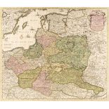
* Poland. De Wit (Frederick), Reipublicae et Status Generalis Poloniae Nova Tabula, Comprehendens Maioris et Minoris Poloniae Regni, Magni Ducatus...
* Poland. Gastaldi (G.), Il Disegno de Geografia Moderna del Regno di Polonia, e Parte del Ducado di Moscovia, con parte della Scandia, e parte de...
* Poland. Homann (Johann Baptiste, heirs of), Comitatus Glaciensis tabula..., Nuremberg, 1747, engraved map with contemporary hand colouring and s...
* Poland. Homann (Johann Baptist), Regnum Borussiae..., Nuremberg, circa 1710, engraved map with contemporary hand colouring and some later enhanc...
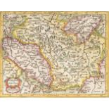
Poland. Hondius (Jodocus & Purchas, Samuel), Polonia et Silesia, circa 1625, hand-coloured engraved map, English text below and on verso, addition...
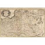
* Poland. Jaillot (Alexis Hubert), Estats de Pologne Subdivisés suivant l'estendue des Palatinats par le Sr. Sanson...., Paris,1692, large engrave...