Refine your search
Sale Section
- 20th century (3)
- Advertising (5)
- Books (3)
- Clocks (1)
- Furniture (5)
- glass (2)
- Jewellery (3)
- Maps (142)
- Medals (1)
- Militaria (1)
- music (4)
- Oriental (4)
- Pens (5)
- pictures (23)
- Porcelain (2)
- Postcards (1)
- Railway (2)
- Scientific (26)
- Silver (19)
- sporting (20)
- Taxidermy (29)
- Toys and Games (9)
- Tribal (29)
- Walking sticks (3)
- Watches (2)
- Wines and Spirits (6)
- Works of Art (120)
Estimate
Category
- Maps (125)
- Taxidermy & Natural History (34)
- Ethnographica & Tribal Art (33)
- Collectables (27)
- Arms, Armour & Militaria (24)
- Sculpture (19)
- Scientific Instruments (18)
- Books & Periodicals (17)
- Models, Toys, Dolls & Games (15)
- Silver & Silver-plated items (15)
- Sporting Memorabilia & Equipment (13)
- Writing Instruments (12)
- Prints (10)
- Vintage Fashion (9)
- Jewellery (8)
- Metalware (8)
- Wines & Spirits (8)
- Photographs (7)
- Furniture (6)
- Kitchenalia (6)
- Salvage & Architectural Antiques (6)
- Tools (5)
- Watercolours (5)
- Ceramics (4)
- Japanese Works of Art (4)
- Musical Instruments & Memorabilia (4)
- Barometers (3)
- Chinese Works of Art (3)
- Clocks (3)
- Stamps (3)
- Textiles (3)
- Cameras & Camera Equipment (2)
- Lighting (2)
- Oil, Acrylic paintings & Mixed Media (2)
- Watches & Watch accessories (2)
- Bank notes (1)
- Classic Cars, Motorcycles & Automobilia (1)
- Drawings & Pastels (1)
- Glassware (1)
- Islamic Works of Art (1)
- List
- Grid
A subscription to the Price Guide is required to view results for auctions ten days or older. Click here for more information


C. Greenwood, coloured map engraving, "Map of the East Riding of the County of York from an actual
C. Greenwood, coloured map engraving, "Map of the East Riding of the County of York from an actual survey made in the years 1831 & 1832 by C. Gree...

T.B. Johnston, coloured map, Greece, mounted, the map 44cm x 58cm
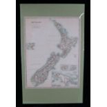
Keith Johnston, coloured map, New Zealand, with cartouches depicting Auckland, Wellington, Dunedin
Keith Johnston, coloured map, New Zealand, with cartouches depicting Auckland, Wellington, Dunedin and New Guinea, mounted, the map 45cm x 58cm ....

Collection of French engraved maps, to include "Carte de la Guinee", "Carte du Detroit de Waeigats
Collection of French engraved maps, to include "Carte de la Guinee", "Carte du Detroit de Waeigats ou de Nassau", "Carte du Paraguay", "Empire du ...

Collection of maps, to include Canada, Canada (Western Provinces), Egypt, Palestine, Australia,
Collection of maps, to include Canada, Canada (Western Provinces), Egypt, Palestine, Australia, Asia, Egypt/Nubia with Abyssinia, Africa, Turkey a...

Eman Bowen for Mr Tindal's continuation of Mr Rapin's history, two coloured map engravings, Germany and the seven united provinces, circa 1740, 45...

Collection of maps depicting coastlines, canals and rivers, to include "Canal de Noel", "A Map of
Collection of maps depicting coastlines, canals and rivers, to include "Canal de Noel", "A Map of the coast and country about Sierra Lione and She...

Yorkshire, a collection of twelve maps, to include North, East and West Riding, some mounted (12)
Yorkshire, a collection of twelve maps, to include North, East and West Riding, some mounted (12)

Collection of twenty British county maps, to include The Dispatch Atlas, Monmouthshire, Lancashire, Hertfordshire, Herefordshire, Hampshire, Durha...

Collection of twenty British county maps, to include The Dispatch Atlas, three England and Wales
Collection of twenty British county maps, to include The Dispatch Atlas, three England and Wales in four sheets, Wales in four sheets, Scotland in...

Collection of fourteen world maps, to include The Dispatch Atlas, Java and Sumatra, Afghanistan,
Collection of fourteen world maps, to include The Dispatch Atlas, Java and Sumatra, Afghanistan, Celebes and the Molucca Islands, New South Wales ...

Maps top include Gall & Inglis' map of West Indies, Colton's Hawaiian group or Sandwich Islands,
Maps top include Gall & Inglis' map of West Indies, Colton's Hawaiian group or Sandwich Islands, Colton's North Carolina, Wisconsin, Mississippi, ...

Alexis Jaillot, coloured map engraving, "Le Comte De Haynaut, Divise en Chattellenies, Ballages,
Alexis Jaillot, coloured map engraving, "Le Comte De Haynaut, Divise en Chattellenies, Ballages, Prevostes &c", 78cm x 57cm, together with a simil...

World maps, coloured and black and white examples, to include Asia, North America, Persia, Channel
World maps, coloured and black and white examples, to include Asia, North America, Persia, Channel Islands, The Baltic sea, Western Hemisphere, Ca...

Christopher Saxton. Anglesey, map engraving circa 1640, 21cm x 32.5cm ...[more]

Colton's coloured maps, to include Central America, Peru and Bolivia, Spain and Portugal, Brazil and
Colton's coloured maps, to include Central America, Peru and Bolivia, Spain and Portugal, Brazil and Guayana, Argentine Republic, Palestine (6)

Collection of twenty British county maps, to include The Dispatch Atlas, Berkshire, Cambridgeshire, Cheshire, Devonshire (North and South division...

W & A.K. Johnston, coloured maps, to include Asia, Egypt Arabia Petraea and Lower Nubia, Turkey in
W & A.K. Johnston, coloured maps, to include Asia, Egypt Arabia Petraea and Lower Nubia, Turkey in Asia (Asia Minor) and Transcaucasia, W. Hughes ...

J & C Walker, England and Scotland coloured maps, to include England canals and railways, Ancient
J & C Walker, England and Scotland coloured maps, to include England canals and railways, Ancient Britain, England I, II and III, IV and V etc. (1...

J & C Walker for the Society for the Diffusion of Useful Knowledge, Scotland coloured maps, to
J & C Walker for the Society for the Diffusion of Useful Knowledge, Scotland coloured maps, to include two Scotland I, II and III, environs of Edi...

World maps to include West Indies, China, Greece, Asia, Turkey in Europe, Egypt, Cape of Good
World maps to include West Indies, China, Greece, Asia, Turkey in Europe, Egypt, Cape of Good Hope, Denmark etc. 42cm x 36.5cm

W. Hughes for George Philip & Son Ltd. a collection of world maps, to include Gallia, Hispania,
W. Hughes for George Philip & Son Ltd. a collection of world maps, to include Gallia, Hispania, Syria, Italia, Grecia etc. (qty) ...[more]
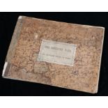
Stuart Murray, "The Goulburn Weir and its dependent system of works. A descriptive memorandum",
Stuart Murray, "The Goulburn Weir and its dependent system of works. A descriptive memorandum", published Victoria Australia 1893, containing vari...

World maps to include North and South Australia, Turkey in Asia, Central America, Greece and the
World maps to include North and South Australia, Turkey in Asia, Central America, Greece and the Aegean, Austrian Dominions, Prussia, Holland & Be...

Collection of Bacon's, Bartholomew and other world maps, to include Africa, Mediterranean, New
Collection of Bacon's, Bartholomew and other world maps, to include Africa, Mediterranean, New Zealand, Japan, Quebec and New Brunswick, Asia, Uni...

Neele for Thomson's new general atlas 1815, coloured map "Western Hemisphere No.5", 53.5cm x 70cm
Neele for Thomson's new general atlas 1815, coloured map "Western Hemisphere No.5", 53.5cm x 70cm

J & C Walker, coloured maps to include Polynesia or Islands in the Pacific Ocean, Asia Minor,
J & C Walker, coloured maps to include Polynesia or Islands in the Pacific Ocean, Asia Minor, Turkey, India IV, Central America, Spain II, III, An...
Captain Granville Collins, coloured map engraving, Milford Haven, 60cm x 47.5cm

Collection of British county maps, to include The Dispatch Atlas, two sets of Wales in four sheets, Worcestershire and Gloucestershire, Wiltshire,...

British County maps, to include Dugdales England and Wales Delineated, Merionethshire, Glamorganshire, Rutlandshire, Staffordshire, Monmouthshire,...

Captain Chaucard, "A reduced map of the Empire of Germany, Holland, the Netherlands, Switzerland,
Captain Chaucard, "A reduced map of the Empire of Germany, Holland, the Netherlands, Switzerland, the Grisons, Italy, Sicily, Corsica & Sardinia",...

Collection of European maps, to include "Gallia Belgica", "Aix la Chapelle", Poland, Madrid,
Collection of European maps, to include "Gallia Belgica", "Aix la Chapelle", Poland, Madrid, Italy (Northern Part), North Italy, three Germany (9)

Military maps, to include two "Aeth a strong frontier town in Brabant taken by the Duke of Marlborough in 1706", "Huy taken by ye Army of the Stat...

Elijah H. Burritt, "Atlas designed to illustrate the geography of the heavens", published Huntington
Elijah H. Burritt, "Atlas designed to illustrate the geography of the heavens", published Huntington and Savage, New York, 1835, containing two si...

Peter Schenk, seven maps depicting forts, to include Winochs-Bergen, Stevens-Waart, Kiesterswaart,
Peter Schenk, seven maps depicting forts, to include Winochs-Bergen, Stevens-Waart, Kiesterswaart, two Aath, Manheim, Grenvilengen (7)

R.W. Seale, coloured map engravings, Hanover and Germany 31.5cm x 39cm and 39cm x 31.5cm (2)
R.W. Seale, coloured map engravings, Hanover and Germany 31.5cm x 39cm and 39cm x 31.5cm (2)

Four French maps, "Carte du Paraguay", "Carte de la Guyane", "Carte de la Guiane", "Carte du
Four French maps, "Carte du Paraguay", "Carte de la Guyane", "Carte de la Guiane", "Carte du Perou" (4)

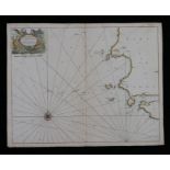
Tindal, two ocean charts, "A Correct Chart of the German Ocean...", "A Correct Chart of the Bay of
Tindal, two ocean charts, "A Correct Chart of the German Ocean...", "A Correct Chart of the Bay of Biscay, Part of the Western Ocean & Mediterrane...
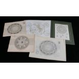
Celestial and other charts, to include "Astronomy fig.6 The motion of Venus and Mercury in respect
Celestial and other charts, to include "Astronomy fig.6 The motion of Venus and Mercury in respect of the earth", two "Annual revolution of the ea...

Collection of fifteen world maps, to include The Dispatch Atlas, Afghanistan, Syria, Central
Collection of fifteen world maps, to include The Dispatch Atlas, Afghanistan, Syria, Central America, South America, China etc. (15)
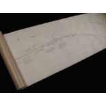
Railwayana- railway line plan, "City & County Borough of Coventry", including the lines through
Railwayana- railway line plan, "City & County Borough of Coventry", including the lines through the parishes of St Michael, Holy Trinity Within, H...

Railwayana- railway line plan, "Parish of Norton under Cannock Urban District of Brownhills, scale 2
Railwayana- railway line plan, "Parish of Norton under Cannock Urban District of Brownhills, scale 2 chains to 1 inch, titled to backing "NORTON C...

A. Arrowsmith, "Map exhibiting the great post roads, physical and political divisions of Europe",
A. Arrowsmith, "Map exhibiting the great post roads, physical and political divisions of Europe", 1810, 104cm x 83cm, similar map depicting the In...

C & J Greenwood, county maps to include Northampton, Leicester, Stafford, Northumberland, Worcester,
C & J Greenwood, county maps to include Northampton, Leicester, Stafford, Northumberland, Worcester, Salop, Huntingdon, Monmouth, Glamorgan Brecon...

Two Moordown, Bournemouth Ordnance Survey street maps, 1/1250 scale, 71cm x 102cm

C & J Greenwood, county maps to include Oxford, three Huntingdon, York, two Worcester, Nottingham,
C & J Greenwood, county maps to include Oxford, three Huntingdon, York, two Worcester, Nottingham, Rutland, the Principality of Wales (10) ...[mo...

Christopher Saxton/William Kip, an early 17th century hand-coloured map engraving, "WARWICI -
Christopher Saxton/William Kip, an early 17th century hand-coloured map engraving, "WARWICI - comitatus a cor nauiis olim Inhabitatus, with key, h...

Christopher Saxton/William Kip, an early 17th century hand-coloured map engraving, "Lecestriae -
Christopher Saxton/William Kip, an early 17th century hand-coloured map engraving, "Lecestriae - comitatus sive Leicestershyte pars olim coritanor...

Christopher Saxton, an early 17th century hand-coloured map engraving, "Suffolclae comitatus cuius
Christopher Saxton, an early 17th century hand-coloured map engraving, "Suffolclae comitatus cuius poplui", with key to the names of the hundreds,...

Arron Arrowsmith, Outlines of the World, 1840, engraved title and dedication, forty-four coloured
Arron Arrowsmith, Outlines of the World, 1840, engraved title and dedication, forty-four coloured engraved maps and one engraved sheet listing riv...