Refine your search
Sale Section
- 20th century (3)
- Advertising (5)
- Books (3)
- Clocks (1)
- Furniture (5)
- glass (2)
- Jewellery (3)
- Maps (142)
- Medals (1)
- Militaria (1)
- music (4)
- Oriental (4)
- Pens (5)
- pictures (23)
- Porcelain (2)
- Postcards (1)
- Railway (2)
- Scientific (26)
- Silver (19)
- sporting (20)
- Taxidermy (29)
- Toys and Games (9)
- Tribal (29)
- Walking sticks (3)
- Watches (2)
- Wines and Spirits (6)
- Works of Art (120)
Estimate
Category
- Maps (125)
- Taxidermy & Natural History (34)
- Ethnographica & Tribal Art (33)
- Collectables (27)
- Arms, Armour & Militaria (24)
- Sculpture (19)
- Scientific Instruments (18)
- Books & Periodicals (17)
- Models, Toys, Dolls & Games (15)
- Silver & Silver-plated items (15)
- Sporting Memorabilia & Equipment (13)
- Writing Instruments (12)
- Prints (10)
- Vintage Fashion (9)
- Jewellery (8)
- Metalware (8)
- Wines & Spirits (8)
- Photographs (7)
- Furniture (6)
- Kitchenalia (6)
- Salvage & Architectural Antiques (6)
- Tools (5)
- Watercolours (5)
- Ceramics (4)
- Japanese Works of Art (4)
- Musical Instruments & Memorabilia (4)
- Barometers (3)
- Chinese Works of Art (3)
- Clocks (3)
- Stamps (3)
- Textiles (3)
- Cameras & Camera Equipment (2)
- Lighting (2)
- Oil, Acrylic paintings & Mixed Media (2)
- Watches & Watch accessories (2)
- Bank notes (1)
- Classic Cars, Motorcycles & Automobilia (1)
- Drawings & Pastels (1)
- Glassware (1)
- Islamic Works of Art (1)
- List
- Grid
A subscription to the Price Guide is required to view results for auctions ten days or older. Click here for more information


James Duncan, coloured map engraving, "New map of South Wales containing the District Divisions
James Duncan, coloured map engraving, "New map of South Wales containing the District Divisions and other LOCAL ARRANGEMENTS effected by the REFOR...

Coloured map engraving "LOCAL GOVERNMENT BOUNDARIES COMMISSION, DIAGRAM of the ALTERATIONS PROPOSED BY THE BPUNDARIES COMMISSION IN THE COUNTY OF ...

Coloured map engraving, "GREAT WESTERN RAILWAY, PORT TALBOT DOCKS", mounted, 39cm x 31.5cm

William Morris, map engraving "Swansea, Neath, Aberafon and the Mumble Flats; Bay, Bars and Harbours", published 1800, mounted, 28cm x 19cm

C.F. Cruchley, coloured map engraving, Swansea Bay, circa 1860, mounted, the map 47cm x 20.5cm
C.F. Cruchley, coloured map engraving, Swansea Bay, circa 1860, mounted, the map 47cm x 20.5cm

Coloured map engraving, "South Wales engraved for Roscoe's wanderings & excursions in the principality", mounted, the map 39cm x 30.5cm ...[more]

Henry Teesdale, coloured map engraving, South Wales, mounted, the map 42.5cm x 35cm
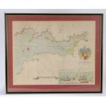
Greenville Collins, coloured map enraving, circa 1693 the Bristol Channel, 'The Severn or Channell
Greenville Collins, coloured map enraving, circa 1693 the Bristol Channel, 'The Severn or Channell of Bristoll', with crest to the Right Honorable...

John Speede, coloured map engraving, "GLAMORGAN SHYRE With the fittuations of the chiefe towne
John Speede, coloured map engraving, "GLAMORGAN SHYRE With the fittuations of the chiefe towne Cardyff and ancient Landaffe defcribed", 1610, with...

John Speede, coloured map engraving, "BREKNOKE BOTH SHYRE AND TOWNE defcribed Ann Domini 1610", with
John Speede, coloured map engraving, "BREKNOKE BOTH SHYRE AND TOWNE defcribed Ann Domini 1610", with cartouche depicting Breknoke town, latin text...

Christopher Saxton and Robert Vaughan, coloured map engraving, "Brecknoc Comitaus pars olim silvrum", housed in a gilt and ebonised glazed frame, ...

Johannes Blaeu, Coloured map engraving, Glamorganshire, "Glamorganensis comitatus vulgo Glamorgan
Johannes Blaeu, Coloured map engraving, Glamorganshire, "Glamorganensis comitatus vulgo Glamorgan Shire", circa 1648, Latin text verso, housed in ...

Coloured map engraving, Aberavon, Margam, Pont-Y-Rhyll & Port Talbot, Briton Ferry, Cardonnel, Court
Coloured map engraving, Aberavon, Margam, Pont-Y-Rhyll & Port Talbot, Briton Ferry, Cardonnel, Court Sart & Neath, showing the railway lines and s...

John Norden, coloured map engraving, Wales, with distance table, originally from "A Direction for an
John Norden, coloured map engraving, Wales, with distance table, originally from "A Direction for an English Traviller", published posthumously 16...

Thomas Kitchin, map engraving, "A new map of Glamorganshire", housed in an ebonised and gilt
Thomas Kitchin, map engraving, "A new map of Glamorganshire", housed in an ebonised and gilt glazed frame with red mount, the map 26.5cm x 21.5cm ...

Carrington Bowles, coloured map engraving, "Bowle's new medium map of South Wales", 1785, housed
Carrington Bowles, coloured map engraving, "Bowle's new medium map of South Wales", 1785, housed in a gilt and ebonised glazed frame, the map 34.5...

Gulielmus Hole, coloured map engraving, Glarmorgan, housed in a gilt and ebonised glazed frame,
Gulielmus Hole, coloured map engraving, Glarmorgan, housed in a gilt and ebonised glazed frame, the map 34.5cm x 29cm
William Heather, coloured map engraving, "A New Chart of Bristol Channel Reduced from the Best
William Heather, coloured map engraving, "A New Chart of Bristol Channel Reduced from the Best Authorities by W. Heather", with three cartouches d...

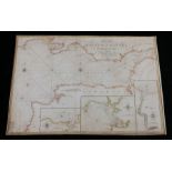
C & J Greenwood, coloured map engraving, "Map of the South East Circuit of the Principality of Wales
C & J Greenwood, coloured map engraving, "Map of the South East Circuit of the Principality of Wales Comprising the Counties of Glamorgan, Brecon ...

Thomas Kitchin, coloured map engraving, "An accurate map of Carmarthenshire", with cartouche
Thomas Kitchin, coloured map engraving, "An accurate map of Carmarthenshire", with cartouche depicting "S.E. view of Carmarthen", "An accurate map...

J. Jansson, coloured map engraving, South Wales, "Walliae pars australis vulgo South-Wales",
J. Jansson, coloured map engraving, South Wales, "Walliae pars australis vulgo South-Wales", mounted, 53cm x 42cm

Coloured star chart "STEREOGRAPHISCHER ENTWURF DES GESTIRNTEN HIMMELS vom Nordpol bis zum 38sten
Coloured star chart "STEREOGRAPHISCHER ENTWURF DES GESTIRNTEN HIMMELS vom Nordpol bis zum 38sten grad sudlicher Abweichung von Herrn I Bode Neu he...

John Speed, circa 1610, Buckingham both Shyre and Shire towne described', dated 1610, the double
John Speed, circa 1610, Buckingham both Shyre and Shire towne described', dated 1610, the double aspect frame showing verso 'Buckinghamshire Book ...

Emanuel Bowen, (1693-1767) County of Suffolk, profusely inscribed and titled in cartouche with
Emanuel Bowen, (1693-1767) County of Suffolk, profusely inscribed and titled in cartouche with dedication to Charles Duke of Grafton, cloth backed...

Three Edward Stanford maps of the British isles, to include Geological, Hydrographical and Parliamentary maps, 56.5cm x 66.5cm (3)

Coloured map of the Eastern Hemisphere, published by Henry Teesdale, The Dispatch Atlas map of the
Coloured map of the Eastern Hemisphere, published by Henry Teesdale, The Dispatch Atlas map of the world on Mercators projection, engraved by Edwa...
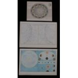
I Dower, annual revolution of the earth round the sun, J Bartholomew, Northern and Southern celestial hemispheres, J Bartholomew, the solar system...

Charles Francois Delamarche, "Tableau Analytique des differentes positions de la sphere, des
Charles Francois Delamarche, "Tableau Analytique des differentes positions de la sphere, des differens systemes. des revolutions ed des distances ...
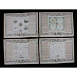
Four French astrological documents with central depictions of the paths of the planets, "demonstrations gerometriques des spheres droite, paralell...

C. Paas, coloured map engraving, "Germany divided into its's circles", mounted, the map 30cm x 22.
C. Paas, coloured map engraving, "Germany divided into its's circles", mounted, the map 30cm x 22.5cm

Christopher Saxton, map engraving "EBORACENSIS ...... EAST RIDING", mounted, the map 27cm x 22cm
Christopher Saxton, map engraving "EBORACENSIS ...... EAST RIDING", mounted, the map 27cm x 22cm

Hollar Wenceslaus, coloured map engraving, "The Mappe of Norfolke, Suffolke, Cambridgeshire..."
Hollar Wenceslaus, coloured map engraving, "The Mappe of Norfolke, Suffolke, Cambridgeshire..." ...[more]

R.W. Seale, 18th Century map engraving, "A MAP OF SOUTH AMERICA, with all the European settlements & whatever else is remarkable from the latest ...

J & C Walker coloured map, Scotland, county maps to include Cornwall, Isle of Wight, Shetland and
J & C Walker coloured map, Scotland, county maps to include Cornwall, Isle of Wight, Shetland and Orkney Islands, Lincolnshire, the British Channe...

Edward Weller, coloured map, Scotland, formed from four sheets, Wales, formed from four sheets (2)
Edward Weller, coloured map, Scotland, formed from four sheets, Wales, formed from four sheets (2) ...[more]

Robert Morden, coloured map engraving, Essex, mounted, 44cm x 38cm

Great Britain and Europe maps, to include Eman Bowen map of Germany, North Italy, British Isles,
Great Britain and Europe maps, to include Eman Bowen map of Germany, North Italy, British Isles, British Isles France Holland & Belgium, two Europ...

India and other maps, to include S. Hall map of India, The Dispatch Atlas map of Lucknow, J.
India and other maps, to include S. Hall map of India, The Dispatch Atlas map of Lucknow, J. Bartholomew map of the Indian Archipelago, Edward Wel...

Australia, New Zealand and other maps, to include Queensland, South Wales and Victoria, Australia
Australia, New Zealand and other maps, to include Queensland, South Wales and Victoria, Australia and New Zealand, Australia, Celebes and Molucca ...

Maps to include T. Kitchin map of Cape Verde, two East Indies, three West Indies, Mexico, The West
Maps to include T. Kitchin map of Cape Verde, two East Indies, three West Indies, Mexico, The West Indies and Central America, West India Islands ...

United States and Canada maps, to include Eastern United States, North America Sheets I, III, VIII
United States and Canada maps, to include Eastern United States, North America Sheets I, III, VIII and IX, British Possessions North America, Nort...

United States and Canada maps, to include Lower Canada New Brunswick Nova Scotia &c, North America
United States and Canada maps, to include Lower Canada New Brunswick Nova Scotia &c, North America Sheet I and II, two North America, Canada New B...

"SIX MAPS OF THE STARS PUBLISHED UNDER THE SUPERINTENDENCE OF THE SOCIETY FOR THE DIFFUSION OF
"SIX MAPS OF THE STARS PUBLISHED UNDER THE SUPERINTENDENCE OF THE SOCIETY FOR THE DIFFUSION OF USEFUL KNOWLEDGE", published London 1830 by Baldwin...

Coastline coloured map etching, "Burlington Bay, Scarborough and Hartlepool. to Capt. Ralph Sanderson, this chart is a dedicated and prefented by ...

The Dispatch Atlas map, "Plan of Paris & the surrounding communes shewing the fortifications & all
The Dispatch Atlas map, "Plan of Paris & the surrounding communes shewing the fortifications & all modern improvements" ...[more]

Coastline map etching, "Burlington Bay, Scarborough and Hartlepool. to Capt. Ralph Sanderson, this
Coastline map etching, "Burlington Bay, Scarborough and Hartlepool. to Capt. Ralph Sanderson, this chart is a dedicated and prefented by Cap't Gre...

Spain, Justus Danckerts (1635-1701) Accuratis sima Totius Regini Hispania Tabula Per Iustinum
Spain, Justus Danckerts (1635-1701) Accuratis sima Totius Regini Hispania Tabula Per Iustinum Danckerts, hand coloured map, 61cm x 51cm ...[more]

Mediterranean, Samuel John Neele (1758-1824) Sardinia and Sicily, Published by John Stockdale,
Mediterranean, Samuel John Neele (1758-1824) Sardinia and Sicily, Published by John Stockdale, Piccadilly 12 March 1800, 90cm x 56cm ...[more]

Collection of The Dispatch Atlas world maps, to include Italy, Corsica & Sardinia, Naples Northern
Collection of The Dispatch Atlas world maps, to include Italy, Corsica & Sardinia, Naples Northern Portion, Naples Southern Portion and Sicily, Lo...

Collection of The Dispatch Atlas world maps, to include Russian in Asia (2 pages), Algeria and
Collection of The Dispatch Atlas world maps, to include Russian in Asia (2 pages), Algeria and Tunis, Western Africa, South Central Africa, Cape o...

Collection of The Dispatch Atlas world maps, to include Central America, South America (2 sheets),
Collection of The Dispatch Atlas world maps, to include Central America, South America (2 sheets), Southern States of South America (2 sheets), Br...

Edward Weller, coloured map engravings, Western Africa, Marocco (sic) Algeria & Tunis, Africa (3)
Edward Weller, coloured map engravings, Western Africa, Marocco (sic) Algeria & Tunis, Africa (3) ...[more]

J. Bartholomew, coloured map engravings, The World on Mercator's Projection, Oceania and Pacific
J. Bartholomew, coloured map engravings, The World on Mercator's Projection, Oceania and Pacific Ocean, North America, British America, Canada, Ne...

Christopher Saxton and William Hole, coloured map engraving, Northumbria, "Northumbriae Comitatus
Christopher Saxton and William Hole, coloured map engraving, Northumbria, "Northumbriae Comitatus olim sedes Otadinorum", mounted, the map 32cm x ...

E Weller, the Environs of Paris, four sheet map (4)

Collection of The Dispatch Atlas county maps, to include Northamptonshire, Hampshire, Norfolk,
Collection of The Dispatch Atlas county maps, to include Northamptonshire, Hampshire, Norfolk, Suffolk, Essex, Dorsetshire, Kent, Oxfordshire etc....

Collection of maps, to include The Crimea, Tennessee Western Part, Nubia with Abyssinia, Syria (2
Collection of maps, to include The Crimea, Tennessee Western Part, Nubia with Abyssinia, Syria (2 sheets), Egypt, Palestine, Australia, Victoria, ...

B.R. Davies, The Dispatch Atlas map engraving, Liverpool, circa 1860, 48.5cm x 66.5cm ...[more]

Ioannem Iansonium, map engraving, "Champagne Comitatus Campania", with English text verso, 58.5cm
Ioannem Iansonium, map engraving, "Champagne Comitatus Campania", with English text verso, 58.5cm x 50cm

Dunbar, map engraving "A DRAUGHT OF PORTLAND THE SHAMBLES AND THE RACE OF PORTLAND", 62cm x 53cm
Dunbar, map engraving "A DRAUGHT OF PORTLAND THE SHAMBLES AND THE RACE OF PORTLAND", 62cm x 53cm