2
Jean Baptiste Clouet Carte d'Afrique divisée en ses principaux Etats… / La Africa dividida
1/4


Description
Jean Baptiste Clouet Carte d'Afrique divisée en ses principaux Etats… / La Africa dividida segun lo dila de sus principales partes ….
Mondhare & Jean
Paris & Cadiz
1785
Good
122cm x 97cm
Stunningly beautiful wall map, with historiated border, which also shows Cook's voyages. One of the few of these all maps to survive in good condition. A work of art.
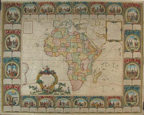
L'abbé Jean Baptiste Louis Clouet (1729 – 1790) was a French cartographer and geographer born 1729 in Rennes. He was a member of the Academy of Science in Rouen. His main work was the Géographie Moderne, which first was issued in 1767. This carte de cabinet (a wall map) is one of a set of four continents and the world (five maps in all), all with historiated borders, published in 1785 by Mondhare & Jean in Paris and Cadiz.
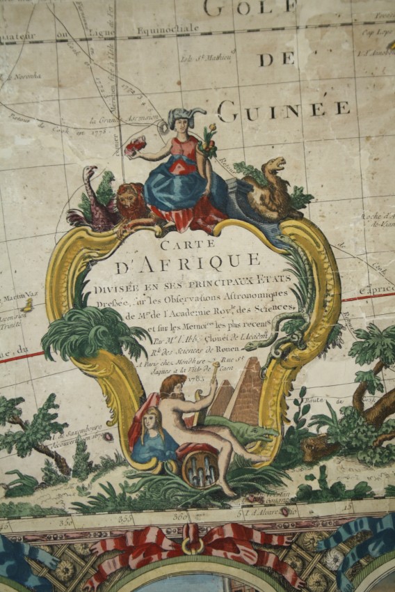
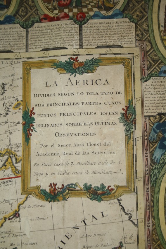
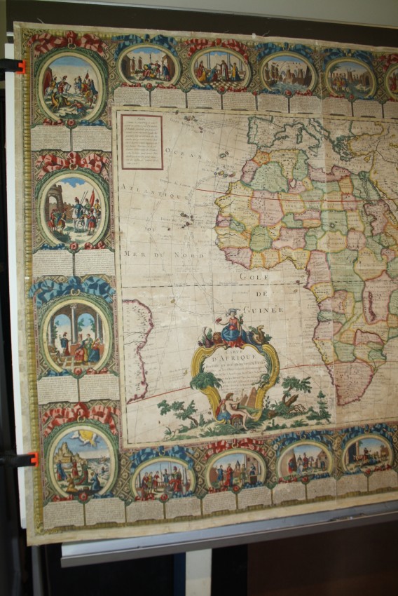
This map of Africa is printed on four sheets which are joined and laid on reinforcing linen. This is a beautiful wall map of Africa, with two title cartouches; the principal one in French and another in Spanish. The main cartouche is elaborate and richly embellished with iconography representing various features of Africa, e.g. Africa is personified by a Ceres like female figure wearing an elephant scalp headdress from Roman iconography – and she is holding a cornucopia; pyramids; and a crocodile representing the Nile River.
The rococo border is made up of twenty vignettes, which are scenes from African history and myth, all in brilliant full colour. Each vignette has a short explanatory text in French and Spanish. The scenes include the first commercial contacts of Europeans with inhabitants of Guinea; discovery and Christianisation in the Congo; Siege of Tripoli; the foundation of Carthage; the defeat of Hannibal by Scipio Africanus; conquests by the Greeks, Romans, Vandals and Turks; and the crossing of the Red Sea led by Moses (illustrated below).
The mythology, iconography and ancient history is balanced by evidence of recent discovery, e.g. the three voyages of Captain James Cook are drawn and annotated. But ‘misdiscovery’ is also included on the map in the form of least three phantom islands: Saxembourg (35° S and 350°), Jean de Lisboa (SE of Madagascar) and Romeiros further east.
Although Europeans had not yet discovered it, Lake Maravi (Malawi, previously Nyasa) is shown prominently (this follows Delisle’s 1722 map). Tooley and Norwich merely mention Clouet's wall map of the continents in passing. It is likely that neither had seen this map.
This example of the map has undergone restoration before the era of modern technology – these ‘defects’ remind us of the fragility of large wall maps – they tend to deteriorate over time and, therefore, surviving examples are scarce and flawless examples probably do not exist.
Fewer than ten Clouet’s wall maps of Africa have been on the market in the past 35 years.
This uncommon wall map with its historiated borders is one of the aesthetically magnificent historical maps of Africa.
Delivery of this large map will be within a wide diameter tube, which will incur additional costs.
Mondhare & Jean
Paris & Cadiz
1785
Good
122cm x 97cm
Auction Details
Shipping
T&Cs & Important Info
Ask seller a question
Jean Baptiste Clouet Carte d'Afrique divisée en ses principaux Etats… / La Africa dividida segun lo dila de sus principales partes ….
Mondhare & Jean
Paris & Cadiz
1785
Good
122cm x 97cm
Stunningly beautiful wall map, with historiated border, which also shows Cook's voyages. One of the few of these all maps to survive in good condition. A work of art.
L'abbé Jean Baptiste Louis Clouet (1729 – 1790) was a French cartographer and geographer born 1729 in Rennes. He was a member of the Academy of Science in Rouen. His main work was the Géographie Moderne, which first was issued in 1767. This carte de cabinet (a wall map) is one of a set of four continents and the world (five maps in all), all with historiated borders, published in 1785 by Mondhare & Jean in Paris and Cadiz.
This map of Africa is printed on four sheets which are joined and laid on reinforcing linen. This is a beautiful wall map of Africa, with two title cartouches; the principal one in French and another in Spanish. The main cartouche is elaborate and richly embellished with iconography representing various features of Africa, e.g. Africa is personified by a Ceres like female figure wearing an elephant scalp headdress from Roman iconography – and she is holding a cornucopia; pyramids; and a crocodile representing the Nile River.
The rococo border is made up of twenty vignettes, which are scenes from African history and myth, all in brilliant full colour. Each vignette has a short explanatory text in French and Spanish. The scenes include the first commercial contacts of Europeans with inhabitants of Guinea; discovery and Christianisation in the Congo; Siege of Tripoli; the foundation of Carthage; the defeat of Hannibal by Scipio Africanus; conquests by the Greeks, Romans, Vandals and Turks; and the crossing of the Red Sea led by Moses (illustrated below).
The mythology, iconography and ancient history is balanced by evidence of recent discovery, e.g. the three voyages of Captain James Cook are drawn and annotated. But ‘misdiscovery’ is also included on the map in the form of least three phantom islands: Saxembourg (35° S and 350°), Jean de Lisboa (SE of Madagascar) and Romeiros further east.
Although Europeans had not yet discovered it, Lake Maravi (Malawi, previously Nyasa) is shown prominently (this follows Delisle’s 1722 map). Tooley and Norwich merely mention Clouet's wall map of the continents in passing. It is likely that neither had seen this map.
This example of the map has undergone restoration before the era of modern technology – these ‘defects’ remind us of the fragility of large wall maps – they tend to deteriorate over time and, therefore, surviving examples are scarce and flawless examples probably do not exist.
Fewer than ten Clouet’s wall maps of Africa have been on the market in the past 35 years.
This uncommon wall map with its historiated borders is one of the aesthetically magnificent historical maps of Africa.
Delivery of this large map will be within a wide diameter tube, which will incur additional costs.
Mondhare & Jean
Paris & Cadiz
1785
Good
122cm x 97cm
Online Rare Books, Maps & Prints and Photography Auction
Sale Date(s)
Venue Address
Online only auction
AntiquarianAuctions.com
-
-
United Kingdom
General delivery information available from the auctioneer
Registration on AntiquarianAuctions.com is free of charge.
As a successful bidder you will receive an invoice from the seller after the auction. The seller will only invoice the final selling price. We do not charge a buyer’s premium and no VAT applies.
The buyer pays for shipping and insurance costs which can be requested from the seller before the end of the sale.
Important Information
This is an online only auction. Please visit AntiquarianAuctions.com for further information about a lot and to bid
Terms & Conditions
There is no buyer’s premium charged on AntiquarianAuctions.com
AntiquarianAuctions.com is an online rare book auction website. All lots are listed by recognised booksellers who have been vetted before being accepted to sell on the site. This allows buyers to bid with confidence and ensures that lots are accurately described.
Bidding will begin on 19 January at 4.30 pm (UK time) and ends on 26 January at 4.30 pm (UK time). Please follow the countdown on AntiquarianAuctions.com.
Please visit AntiquarianAuctions.com for further information about a lot and to bid