19
Thomas Bowen New and Accurate Map of Africa This attractive 1779 map of Africa was produced by

Description
Thomas Bowen New and Accurate Map of Africa
J Cooke
London
1779
Very good
42.5cm x 32.0cm
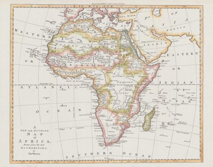
This attractive 1779 map of Africa was produced by Thomas, the son of the highly regarded Emanuel Bowen, Geographer to the Kings of England and France.
Thomas drew and engraved this map for inclusion in Charles Middleton's A New and Complete System of Geography Containing a Full, Accurate, Authentic and Interesting Account and Description of Europe, Asia, Africa and America, which was published by J.Cooke in 1779.
The geography of this map is transitional. Surprisingly, Bowen retains the Ptolemaic geography of the Nile's origin from the twin lakes near the Mountains of the Moon, although Delsisle had corrected this at the beginning of the 18th century. On the other hand, Lake Maravi (now Malawi, formerly Nyassa) is prominent, and he notes Massi, a Kingdom; Delisle included the lake in the 1722 update of his landmark 1700 map. So, in this regard, Bowen's geography is up to date.
Another state of this map has 1777 in the title; the map was also used in 1787 for Bankes's New System of Geography.
The map was issued uncoloured and had subsequently been outline-coloured; it is in very good condition.
J Cooke
London
1779
Very good
42.5cm x 32.0cm
Auction Details
Shipping
T&Cs & Important Info
Ask seller a question
Thomas Bowen New and Accurate Map of Africa
J Cooke
London
1779
Very good
42.5cm x 32.0cm
This attractive 1779 map of Africa was produced by Thomas, the son of the highly regarded Emanuel Bowen, Geographer to the Kings of England and France.
Thomas drew and engraved this map for inclusion in Charles Middleton's A New and Complete System of Geography Containing a Full, Accurate, Authentic and Interesting Account and Description of Europe, Asia, Africa and America, which was published by J.Cooke in 1779.
The geography of this map is transitional. Surprisingly, Bowen retains the Ptolemaic geography of the Nile's origin from the twin lakes near the Mountains of the Moon, although Delsisle had corrected this at the beginning of the 18th century. On the other hand, Lake Maravi (now Malawi, formerly Nyassa) is prominent, and he notes Massi, a Kingdom; Delisle included the lake in the 1722 update of his landmark 1700 map. So, in this regard, Bowen's geography is up to date.
Another state of this map has 1777 in the title; the map was also used in 1787 for Bankes's New System of Geography.
The map was issued uncoloured and had subsequently been outline-coloured; it is in very good condition.
J Cooke
London
1779
Very good
42.5cm x 32.0cm
Online Rare Books, Maps & Prints and Photography Auction
Sale Date(s)
Venue Address
Online only auction
AntiquarianAuctions.com
-
-
United Kingdom
General delivery information available from the auctioneer
Registration on AntiquarianAuctions.com is free of charge.
As a successful bidder you will receive an invoice from the seller after the auction. The seller will only invoice the final selling price. We do not charge a buyer’s premium and no VAT applies.
The buyer pays for shipping and insurance costs which can be requested from the seller before the end of the sale.
Important Information
This is an online only auction. Please visit AntiquarianAuctions.com for further information about a lot and to bid
Terms & Conditions
There is no buyer’s premium charged on AntiquarianAuctions.com
AntiquarianAuctions.com is an online rare book auction website. All lots are listed by recognised booksellers who have been vetted before being accepted to sell on the site. This allows buyers to bid with confidence and ensures that lots are accurately described.
Bidding will begin on 19 January at 4.30 pm (UK time) and ends on 26 January at 4.30 pm (UK time). Please follow the countdown on AntiquarianAuctions.com.
Please visit AntiquarianAuctions.com for further information about a lot and to bid