46
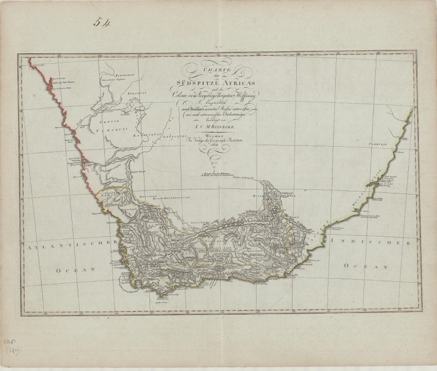
Johann M C Reinecke Charte der Sudspitze Africa und der Colonie vom Vorgebirgedernugen Hoffnung

Description
Johann M C Reinecke Charte der Sudspitze Africa und der Colonie vom Vorgebirgedernugen Hoffnung
J Reinecke
Weimar
1802
Fine
58cm x 38cm
Uncommon German edition of the first modern map of South Africa, based on John Barrow.
This map was featured in a recent exhibition in Princeton, USA with the following commentary:
'Detailed map of South Africa, published in Weimar in 1802, based upon a map produced by Sir John Barrow, which is considered the first modern map of South Africa.The map shows the settled and unknown regions, with topographical features depicted.The outcome of his journeys was a map which, despite its numerous errors, was the first published modern map of the southern parts of the Cape Colony.
'Reinecke was the official cartographer to the Geographical Institute in Weimar, which produced some of the finest world atlases in Germany during the 19th century. On this map, he has outlined in yellow the boundary of the Cape Colony and its several districts. As indicated in the title, it is chiefly based on the 1797-1798 travels of Sir John Barrow, who published his two-volume account in London between 1801 and 1804; hence, the map contains information that was as up-to-date as possible. Accompanying Lord Macartney, who had been sent to Cape Town in 1797 as the first governor of Britain’s new colony, Barrow travelled extensively into the interior.'
This map is printed on original, heavy paper that has an uncommon light blue colour. The map and paper are in fine condition.
Reference:
Not in Tooley or Norwich
https://libweb5.princeton.edu/visual_materials/maps/websites/africa/maps-southern/southern.html
J Reinecke
Weimar
1802
Fine
58cm x 38cm
Auction Details
Shipping
T&Cs & Important Info
Ask seller a question
Johann M C Reinecke Charte der Sudspitze Africa und der Colonie vom Vorgebirgedernugen Hoffnung
J Reinecke
Weimar
1802
Fine
58cm x 38cm
Uncommon German edition of the first modern map of South Africa, based on John Barrow.
This map was featured in a recent exhibition in Princeton, USA with the following commentary:
'Detailed map of South Africa, published in Weimar in 1802, based upon a map produced by Sir John Barrow, which is considered the first modern map of South Africa.The map shows the settled and unknown regions, with topographical features depicted.The outcome of his journeys was a map which, despite its numerous errors, was the first published modern map of the southern parts of the Cape Colony.
'Reinecke was the official cartographer to the Geographical Institute in Weimar, which produced some of the finest world atlases in Germany during the 19th century. On this map, he has outlined in yellow the boundary of the Cape Colony and its several districts. As indicated in the title, it is chiefly based on the 1797-1798 travels of Sir John Barrow, who published his two-volume account in London between 1801 and 1804; hence, the map contains information that was as up-to-date as possible. Accompanying Lord Macartney, who had been sent to Cape Town in 1797 as the first governor of Britain’s new colony, Barrow travelled extensively into the interior.'
This map is printed on original, heavy paper that has an uncommon light blue colour. The map and paper are in fine condition.
Reference:
Not in Tooley or Norwich
https://libweb5.princeton.edu/visual_materials/maps/websites/africa/maps-southern/southern.html
J Reinecke
Weimar
1802
Fine
58cm x 38cm
Online Rare Books, Maps & Prints and Photography Auction
Sale Date(s)
Venue Address
Online only auction
AntiquarianAuctions.com
-
-
United Kingdom
General delivery information available from the auctioneer
Registration on AntiquarianAuctions.com is free of charge.
As a successful bidder you will receive an invoice from the seller after the auction. The seller will only invoice the final selling price. We do not charge a buyer’s premium and no VAT applies.
The buyer pays for shipping and insurance costs which can be requested from the seller before the end of the sale.
Important Information
This is an online only auction. Please visit AntiquarianAuctions.com for further information about a lot and to bid
Terms & Conditions
There is no buyer’s premium charged on AntiquarianAuctions.com
AntiquarianAuctions.com is an online rare book auction website. All lots are listed by recognised booksellers who have been vetted before being accepted to sell on the site. This allows buyers to bid with confidence and ensures that lots are accurately described.
Bidding will begin on 19 January at 4.30 pm (UK time) and ends on 26 January at 4.30 pm (UK time). Please follow the countdown on AntiquarianAuctions.com.
Please visit AntiquarianAuctions.com for further information about a lot and to bid