27
Philipp Vandermaelen Afrique Cap de Bonne Esperance. No. 53 & No. 54 This lot comprises two maps
1/3


Description
Philipp Vandermaelen Afrique Cap de Bonne Esperance. No. 53 & No. 54
Philippe Vandermaelen
Brussels
1826
Fine
Visit AntiquarianAuctions.com for further details and to bid
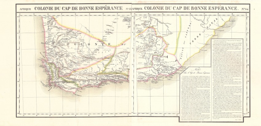
This lot comprises two maps that were drawn as gores that would fit on a globe of the earth >7m in diameter:
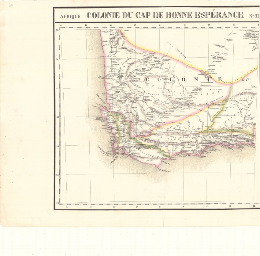
Afrique Cap de Bonne Esperance. No. 53 (50 cm x48cm)
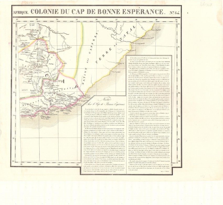
Afrique Cap de Bonne Esperance. No.54 (50 cm x 50cm): with text box
Please read the blog post for more information on Vandermaelen, his atlas and maps; his maps are not included in the cartobibliographies of Tooley or Norwich.
These two very scarce and historically important maps have been reversibly joined - if they were to be position on a globe, the headlines would be removed and the maps would be joined along the lines at an acute angle to the longitude axis - see the image of the maps joined to so that they can be framed conventionally - the western map has been trimmed at the right (eastern) border to facilitate joining of the maps so that they can be appreciated as a whole on a flat surface.
The Cape Colony of the first half of the 1820s is depicted on these two very scarce maps of Philippe Vandermaelen’s Volume III from his Atlas Universel. The maps were early examples of fine lithography, and Vandermaelen's atlas was the first lithographed atlas of the world. The beautiful outline colouring of the maps was done by hand.
The maps show the route and stations of William John Burchell, who travelled extensively in the colony: he departed Cape town in 1811, visited the eastern border region in Cape in 1813 and returned to Cape Town in 1815. His map was published in 1822, four years before Vandermaelen published his own maps.
The maps are in fine condition; the eastern map has a small stain at the margin, outside the plateline: the paper is heavy and firm, the imprint dark and the excellent outline colouring has not faded.
These scarce maps will be a scarce a beautiful addition to any collection of historical maps of the Cape Colony and / or southern Africa.
Selected references
David Rumsey Collection: http://www.davidrumsey.com/home Princeton University: http://libweb5.princeton.edu/visual_materials/maps/websites/vandermaelen/home.htm
Wulf Bodenstein. Around Philippe Vandermaelen in Newsletters 43 & 52 of the Brussels International Map Collectors Society.
Philippe Vandermaelen
Brussels
1826
Fine
Visit AntiquarianAuctions.com for further details and to bid
Auction Details
Shipping
T&Cs & Important Info
Ask seller a question
Philipp Vandermaelen Afrique Cap de Bonne Esperance. No. 53 & No. 54
Philippe Vandermaelen
Brussels
1826
Fine
Visit AntiquarianAuctions.com for further details and to bid
This lot comprises two maps that were drawn as gores that would fit on a globe of the earth >7m in diameter:
Afrique Cap de Bonne Esperance. No. 53 (50 cm x48cm)
Afrique Cap de Bonne Esperance. No.54 (50 cm x 50cm): with text box
Please read the blog post for more information on Vandermaelen, his atlas and maps; his maps are not included in the cartobibliographies of Tooley or Norwich.
These two very scarce and historically important maps have been reversibly joined - if they were to be position on a globe, the headlines would be removed and the maps would be joined along the lines at an acute angle to the longitude axis - see the image of the maps joined to so that they can be framed conventionally - the western map has been trimmed at the right (eastern) border to facilitate joining of the maps so that they can be appreciated as a whole on a flat surface.
The Cape Colony of the first half of the 1820s is depicted on these two very scarce maps of Philippe Vandermaelen’s Volume III from his Atlas Universel. The maps were early examples of fine lithography, and Vandermaelen's atlas was the first lithographed atlas of the world. The beautiful outline colouring of the maps was done by hand.
The maps show the route and stations of William John Burchell, who travelled extensively in the colony: he departed Cape town in 1811, visited the eastern border region in Cape in 1813 and returned to Cape Town in 1815. His map was published in 1822, four years before Vandermaelen published his own maps.
The maps are in fine condition; the eastern map has a small stain at the margin, outside the plateline: the paper is heavy and firm, the imprint dark and the excellent outline colouring has not faded.
These scarce maps will be a scarce a beautiful addition to any collection of historical maps of the Cape Colony and / or southern Africa.
Selected references
David Rumsey Collection: http://www.davidrumsey.com/home Princeton University: http://libweb5.princeton.edu/visual_materials/maps/websites/vandermaelen/home.htm
Wulf Bodenstein. Around Philippe Vandermaelen in Newsletters 43 & 52 of the Brussels International Map Collectors Society.
Philippe Vandermaelen
Brussels
1826
Fine
Visit AntiquarianAuctions.com for further details and to bid
Online Rare Books, Maps & Prints and Photography Auction
Sale Date(s)
Venue Address
Online only auction
AntiquarianAuctions.com
-
-
United Kingdom
General delivery information available from the auctioneer
Registration on AntiquarianAuctions.com is free of charge.
As a successful bidder you will receive an invoice from the seller after the auction. The seller will only invoice the final selling price. We do not charge a buyer’s premium and no VAT applies.
The buyer pays for shipping and insurance costs which can be requested from the seller before the end of the sale.
Important Information
This is an online only auction. Please visit AntiquarianAuctions.com for further information about a lot and to bid
Terms & Conditions
There is no buyer’s premium charged on AntiquarianAuctions.com
AntiquarianAuctions.com is an online rare book auction website. All lots are listed by recognised booksellers who have been vetted before being accepted to sell on the site. This allows buyers to bid with confidence and ensures that lots are accurately described.
Bidding will begin on 26 August at 5.30 pm (UK time) and ends on 1 September at 5.30 pm (UK time). Please follow the countdown on AntiquarianAuctions.com.
Please visit AntiquarianAuctions.com for further information about a lot and to bid