22
Willem Blaeu Aethiopia inferior vel exterior This map of Southern Africa is a valued addition to any
1/2


Description
Willem Blaeu Aethiopia inferior vel exterior
Willem blaeu
Amsterdam
c.1640
Fine
Visit AntiquarianAuctions.com for further details and to bid
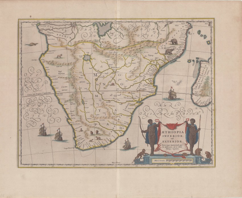
This map of Southern Africa is a valued addition to any collection of historical maps of the region. While there are numerous maps that closely resemble the Blaue edition, most are reaily distinguished. However, the Janssonius map is very similar and both were popular throughout the 17th century.
Blaeu's map is modelled on the ancient geography of Ptolemy. The lake out of which the 'Zambere' (i.e Zambesi) flows is probably based on reports of Lake Ngami, which remained undiscovered by Europeans until 1849; then 20 miles long, today it is only marshland. Europeans had quite good knowledge of the African coast but knew very little about the interior of Africa. This ignorance explains in part why it is filled with animals, although few are accurate representations of indigenous animals.
Willem Jansz. Blaeu c. 1570–1638) was a leading Dutch cartographer and publisher. He died in 1638 and, therefore, most of his maps were published by his son, Joan who, together with his sons, managed one of the largest printing houses in Europe.
Reference: Norwich #154; Tooley p. 29.
Willem blaeu
Amsterdam
c.1640
Fine
Visit AntiquarianAuctions.com for further details and to bid
Auction Details
Shipping
T&Cs & Important Info
Ask seller a question
Willem Blaeu Aethiopia inferior vel exterior
Willem blaeu
Amsterdam
c.1640
Fine
Visit AntiquarianAuctions.com for further details and to bid
This map of Southern Africa is a valued addition to any collection of historical maps of the region. While there are numerous maps that closely resemble the Blaue edition, most are reaily distinguished. However, the Janssonius map is very similar and both were popular throughout the 17th century.
Blaeu's map is modelled on the ancient geography of Ptolemy. The lake out of which the 'Zambere' (i.e Zambesi) flows is probably based on reports of Lake Ngami, which remained undiscovered by Europeans until 1849; then 20 miles long, today it is only marshland. Europeans had quite good knowledge of the African coast but knew very little about the interior of Africa. This ignorance explains in part why it is filled with animals, although few are accurate representations of indigenous animals.
Willem Jansz. Blaeu c. 1570–1638) was a leading Dutch cartographer and publisher. He died in 1638 and, therefore, most of his maps were published by his son, Joan who, together with his sons, managed one of the largest printing houses in Europe.
Reference: Norwich #154; Tooley p. 29.
Willem blaeu
Amsterdam
c.1640
Fine
Visit AntiquarianAuctions.com for further details and to bid
Online Rare Books, Maps & Prints and Photography Auction
Sale Date(s)
Venue Address
Online only auction
AntiquarianAuctions.com
-
-
United Kingdom
General delivery information available from the auctioneer
Registration on AntiquarianAuctions.com is free of charge.
As a successful bidder you will receive an invoice from the seller after the auction. The seller will only invoice the final selling price. We do not charge a buyer’s premium and no VAT applies.
The buyer pays for shipping and insurance costs which can be requested from the seller before the end of the sale.
Important Information
This is an online only auction. Please visit AntiquarianAuctions.com for further information about a lot and to bid
Terms & Conditions
There is no buyer’s premium charged on AntiquarianAuctions.com
AntiquarianAuctions.com is an online rare book auction website. All lots are listed by recognised booksellers who have been vetted before being accepted to sell on the site. This allows buyers to bid with confidence and ensures that lots are accurately described.
Bidding will begin on 26 August at 5.30 pm (UK time) and ends on 1 September at 5.30 pm (UK time). Please follow the countdown on AntiquarianAuctions.com.
Please visit AntiquarianAuctions.com for further information about a lot and to bid