24
Homann Heirs Africa Secundum legitimas projectionis This map was produced in Nuremburg for the

Description
Homann Heirs Africa Secundum legitimas projectionis
Homann Heirs
Hamburg
1737
Fine
Visit AntiquarianAuctions.com for further details and to bid
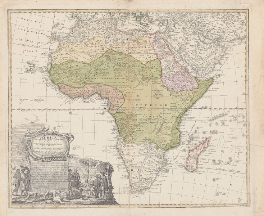
This map was produced in Nuremburg for the heirs of Johan Baptist (1664 – 1724) his son, Johann Christof (1703 – 1730); the Homann Heirs’ company continued to operate until 1824. The map was drawn by Johann Matthias Haas, a mathematician and cartographer, ‘according to the rules and in accordance with the law after the stereographic projection made recently to Africa’ – a similar approach was adopted for other maps – of Europe, for example.
This decorative map provides contemporary knowledge about the coastal regions of the African continent. Angra Penguena on the south-west coast is today’s Luderitz. Haas also incorporated information on inland regions derived from Guillaume Delisle and J d’Anville. He shows the origin of the Blue Nile in Ethiopia but ignores the White Nile. Lake Marawi is today’s Lake Malawi and its depiction preceded discovery by European. He also included the early settlements in the Congo; the about the equator is populated by Anthropophagi (man eaters). At the Cape of Good Hope, he shows the village of Stellenbosch and also ‘Castell Batavor’ – judging by the position of the latter, the name seems to be a corruption of Groot Constantia.
A most striking feature of the map is the decorative cartouche and vignette of a scene at the Cape of Good hope of Europeans and Africans interacting. The lions, a chameleon and tortoise imply a peaceful of cooperation and understanding rather than warfare. Table Bay Mountain in Cape Town are in the distance. With its incorporation of a descriptive text, the cartouche demonstrates how Europeans viewed Africa as an exotic land of both intrigue and potential.
The map is in very good condition.
Homann Heirs
Hamburg
1737
Fine
Visit AntiquarianAuctions.com for further details and to bid
Auction Details
Shipping
T&Cs & Important Info
Ask seller a question
Homann Heirs Africa Secundum legitimas projectionis
Homann Heirs
Hamburg
1737
Fine
Visit AntiquarianAuctions.com for further details and to bid
This map was produced in Nuremburg for the heirs of Johan Baptist (1664 – 1724) his son, Johann Christof (1703 – 1730); the Homann Heirs’ company continued to operate until 1824. The map was drawn by Johann Matthias Haas, a mathematician and cartographer, ‘according to the rules and in accordance with the law after the stereographic projection made recently to Africa’ – a similar approach was adopted for other maps – of Europe, for example.
This decorative map provides contemporary knowledge about the coastal regions of the African continent. Angra Penguena on the south-west coast is today’s Luderitz. Haas also incorporated information on inland regions derived from Guillaume Delisle and J d’Anville. He shows the origin of the Blue Nile in Ethiopia but ignores the White Nile. Lake Marawi is today’s Lake Malawi and its depiction preceded discovery by European. He also included the early settlements in the Congo; the about the equator is populated by Anthropophagi (man eaters). At the Cape of Good Hope, he shows the village of Stellenbosch and also ‘Castell Batavor’ – judging by the position of the latter, the name seems to be a corruption of Groot Constantia.
A most striking feature of the map is the decorative cartouche and vignette of a scene at the Cape of Good hope of Europeans and Africans interacting. The lions, a chameleon and tortoise imply a peaceful of cooperation and understanding rather than warfare. Table Bay Mountain in Cape Town are in the distance. With its incorporation of a descriptive text, the cartouche demonstrates how Europeans viewed Africa as an exotic land of both intrigue and potential.
The map is in very good condition.
Homann Heirs
Hamburg
1737
Fine
Visit AntiquarianAuctions.com for further details and to bid
Online Rare Books, Maps & Prints and Photography Auction
Sale Date(s)
Venue Address
Online only auction
AntiquarianAuctions.com
-
-
United Kingdom
General delivery information available from the auctioneer
Registration on AntiquarianAuctions.com is free of charge.
As a successful bidder you will receive an invoice from the seller after the auction. The seller will only invoice the final selling price. We do not charge a buyer’s premium and no VAT applies.
The buyer pays for shipping and insurance costs which can be requested from the seller before the end of the sale.
Important Information
This is an online only auction. Please visit AntiquarianAuctions.com for further information about a lot and to bid
Terms & Conditions
There is no buyer’s premium charged on AntiquarianAuctions.com
AntiquarianAuctions.com is an online rare book auction website. All lots are listed by recognised booksellers who have been vetted before being accepted to sell on the site. This allows buyers to bid with confidence and ensures that lots are accurately described.
Bidding will begin on 26 August at 5.30 pm (UK time) and ends on 1 September at 5.30 pm (UK time). Please follow the countdown on AntiquarianAuctions.com.
Please visit AntiquarianAuctions.com for further information about a lot and to bid