Sortieren nach:
- Kategorie,
- Lostyp
- Liste
- Galerie
Ein Abonnement der Preisliste ist notwendig um Ergebnisse, von Auktionen die vor einem längeren Zeitraum als 10 Tagen stattgefunden haben, ansehen zu können. Klicken Sie hier für mehr Informationen
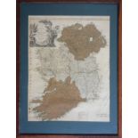

'A New Map of Ireland, Divided into Provinces and Counties' by Thomas Kitchen, 19th century, framed,
'A New Map of Ireland, Divided into Provinces and Counties' by Thomas Kitchen, 19th century, framed, glazed, 61 x 47 cm, (tear 24cm to SW corner o...
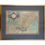
Abraham Ortelius (1527-1698) 'Veronae Urbis Territorium', map of the vicinity of Verona based on the
Abraham Ortelius (1527-1698) 'Veronae Urbis Territorium', map of the vicinity of Verona based on the cartography of Bernardino Brugnoli, engraving...
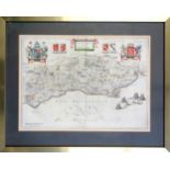
Joan Blaeu (1596-1673) 'Suthsexia vernacule Sussex' map of Sussex, 17th century, Dutch text to
Joan Blaeu (1596-1673) 'Suthsexia vernacule Sussex' map of Sussex, 17th century, Dutch text to reverse, framed, 39 x 53cm; similar framed maps of ...

'Making Friends', 1900 Pears Print, 63 x 47.5cm; Douglas E. West (b.1931) 'Pavilion End', print,
'Making Friends', 1900 Pears Print, 63 x 47.5cm; Douglas E. West (b.1931) 'Pavilion End', print, 37 x 51.5cm; and 'The Elephant and Castle on Brig...