Filtered by:
- Categoria
4 items
- Elenco
- Grid
A subscription to the Price Guide is required to view results for auctions ten days or older. Click here for more information
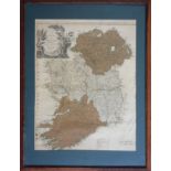

Lotto 111
'A New Map of Ireland, Divided into Provinces and Counties' by Thomas Kitchen, 19th century, framed,
'A New Map of Ireland, Divided into Provinces and Counties' by Thomas Kitchen, 19th century, framed, glazed, 61 x 47 cm, (tear 24cm to SW corner o...
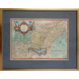
Lotto 112
Abraham Ortelius (1527-1698) 'Veronae Urbis Territorium', map of the vicinity of Verona based on the
Abraham Ortelius (1527-1698) 'Veronae Urbis Territorium', map of the vicinity of Verona based on the cartography of Bernardino Brugnoli, engraving...
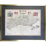
Lotto 113
Joan Blaeu (1596-1673) 'Suthsexia vernacule Sussex' map of Sussex, 17th century, Dutch text to
Joan Blaeu (1596-1673) 'Suthsexia vernacule Sussex' map of Sussex, 17th century, Dutch text to reverse, framed, 39 x 53cm; similar framed maps of ...

Lotto 343
'Making Friends', 1900 Pears Print, 63 x 47.5cm; Douglas E. West (b.1931) 'Pavilion End', print,
'Making Friends', 1900 Pears Print, 63 x 47.5cm; Douglas E. West (b.1931) 'Pavilion End', print, 37 x 51.5cm; and 'The Elephant and Castle on Brig...