Filtered by:
- Categoria
4 items
- Elenco
- Grid
A subscription to the Price Guide is required to view results for auctions ten days or older. Click here for more information
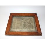

Lotto 459A
An attractive 19th century wool work picture entitled "A New Map of England and Wales", depicting
An attractive 19th century wool work picture entitled "A New Map of England and Wales", depicting England and Wales segregated into counties, with...
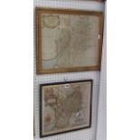
Lotto 738
An 18th century coloured map of Gloucestershire by Robert Morden, 34 x 41 cm approx in moulded and
An 18th century coloured map of Gloucestershire by Robert Morden, 34 x 41 cm approx in moulded and fluted gilt frame together with a further colou...
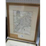
Lotto 778
An 18th century map of Gloucestershire after Blomke inscribed Printed and Sold For Tho Taylor, 25
778An 18th century map of Gloucestershire after Blomke inscribed Printed and Sold For Tho Taylor, 25
An 18th century map of Gloucestershire after Blomke inscribed Printed and Sold For Tho Taylor, 25 x 90 cm approx together with a 19th century map ...
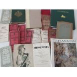
Lotto 857
The Philips' Handy Atlas of the Counties of Ireland together with thirteen early 20th century
The Philips' Handy Atlas of the Counties of Ireland together with thirteen early 20th century Irish OS maps