Filtered by:
- Categoria
- Elenco
- Grid
A subscription to the Price Guide is required to view results for auctions ten days or older. Click here for more information
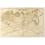

Map of the Russian Empire; Publisher DANIEL LIZARS (Edinburgh, 1754-1812), late 19th century.It
Map of the Russian Empire; Publisher DANIEL LIZARS (Edinburgh, 1754-1812), late 19th century.It has damp stains, soiling, cracks and tears on the ...
Map of Cadiz by NICOLAS DE FER; France, late 19th century. It has damp stains, dirt, cracks and
Map of Cadiz by NICOLAS DE FER; France, late 19th century. It has damp stains, dirt, cracks and wrinkles on the paper.Measurements: 22 x 30 cm.Ma...
Map of Mauritania from the 18th century.Engraving on pages of Ptolemy's Geographia book.Engraver:
Map of Mauritania from the 18th century.Engraving on pages of Ptolemy's Geographia book.Engraver: Girolamo Ruscelli.It shows humidity stains, wrin...
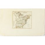
Map of the East Coast of the United States, 19th century.Engraving on paper, illuminated by hand.
Map of the East Coast of the United States, 19th century.Engraving on paper, illuminated by hand.Italian edition.Moisture stains, soiling and crea...
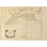
Map of North Africa, 18th century.Engraving on paper.Engraver: Paolo Santini (1729-1793).Publisher: Remondini, Italy.Some stains, dirt, wrinkles.M...
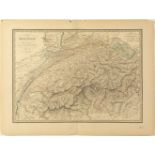
Map of Switzerland from 1851.Edited for P.C. Lehudy in Paris.Engraver: Pierre Tardieu.Moisture
Map of Switzerland from 1851.Edited for P.C. Lehudy in Paris.Engraver: Pierre Tardieu.Moisture stains, soiling and creases. Some lateral faults.Me...
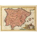
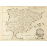
Map of Spain; England, 18th century.Presents damp stains, soiling, cracks and faults on the paper.
Map of Spain; England, 18th century.Presents damp stains, soiling, cracks and faults on the paper.Size: 22,5 x 32 cm (print); 28 x 39,5 cm (paper)...
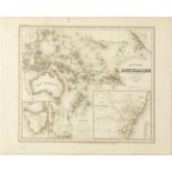
Map of Australia from 1846.Engraving on paper.German edition designed by Hauptm Radefeld.Moisture
Map of Australia from 1846.Engraving on paper.German edition designed by Hauptm Radefeld.Moisture stains, soiling and creases. Missing on the side...
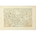
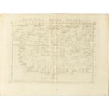
Map of Persia, Georgia and independent Tartary, 19th century.Engraving on paper.Author: Rigobert
Map of Persia, Georgia and independent Tartary, 19th century.Engraving on paper.Author: Rigobert Bonne, Hydrographer to the King of France.Moistur...
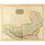
Map of the northern part of European Turkey. 19th century.Engraving on paper.Draughtsman and
Map of the northern part of European Turkey. 19th century.Engraving on paper.Draughtsman and engraver: Thomson's.For the General Atlas. Strasbourg...
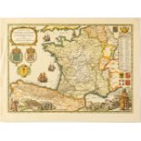
Map of Spain along the Roman itinerary of Antoninus. France, 18th century. Engraving on paper.Made
Map of Spain along the Roman itinerary of Antoninus. France, 18th century. Engraving on paper.Made by the king's geographer Nicolas Sanson.Moistur...
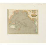
Map of the Pacific Ocean, 19th century.Engraving on paper, illuminated by hand.Design by T.R.
Map of the Pacific Ocean, 19th century.Engraving on paper, illuminated by hand.Design by T.R. Marfhall.Moisture stains, soiling and creasing. Lack...
Map of the roads to Santiago in the style of the 17th-18th century, 20th century.French edition,
Map of the roads to Santiago in the style of the 17th-18th century, 20th century.French edition, 1973.On laid paper.Produced by Daniel Derveux.Wat...
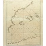
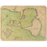
Maritime chart of the Balearic Islands.French edition of 1764.Made in Marseilles by Joseph Roux.
Maritime chart of the Balearic Islands.French edition of 1764.Made in Marseilles by Joseph Roux.Moisture stains, soiling and creases. Some slight ...
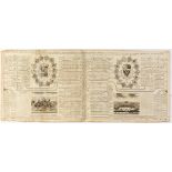
ZACARIAS CHATELAIN and NICHOLAS GUEDDEVILLE. France, 18th century."Genealogical chart of the
ZACARIAS CHATELAIN and NICHOLAS GUEDDEVILLE. France, 18th century."Genealogical chart of the imperial house of Austria". French engraving belongin...
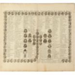
ZACARIAS CHATELAIN and NICHOLAS GUEDDEVILLE. France, 18th century."Genealogical Chart of the Kings
ZACARIAS CHATELAIN and NICHOLAS GUEDDEVILLE. France, 18th century."Genealogical Chart of the Kings of France". French engraving belonging to a boo...
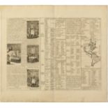
"Government of America. France, 18th century.Engraving on paper.Author: Henri Chatelain (Paris, 1684
"Government of America. France, 18th century.Engraving on paper.Author: Henri Chatelain (Paris, 1684 - 1743)From a French atlas.Some stains, folds...
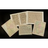
Set of 5 pages of atlases, 18th-19th century.Maps of Russia, Palestine, coast and fortifications
Set of 5 pages of atlases, 18th-19th century.Maps of Russia, Palestine, coast and fortifications of India.Moisture stains, soiling, creases and fo...
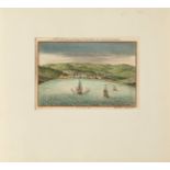
English school of the 18th century."View of Funchal, Madeira". Color engraving.Possibly by the
English school of the 18th century."View of Funchal, Madeira". Color engraving.Possibly by the publisher and bookseller Awnshar Churchill.Presents...
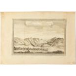
"View of the Great Wall of China". France, 18th century.Etching on paper.Moisture stains, dirt,
"View of the Great Wall of China". France, 18th century.Etching on paper.Moisture stains, dirt, folds and creases. Missing on the sides. Measureme...