Filtered by:
- Categoria
- Elenco
- Grid
Questo banditore ha scelto di non pubblicare i risultati. Contattalo direttamente per qualsiasi domanda.
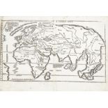

Martin Waldseemuller, German 1470-1520 and Laurent Fries, French 1485-1532- Tabula moderna.
Martin Waldseemuller, German 1470-1520 andLaurent Fries, French 1485-1532- Tabula moderna. Gronlandiae et Russia, &Untitled World Map; woodblock p...
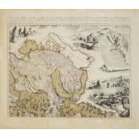
Johann Jakob Scheuchzer, Swiss 1672-1733- Nova Helvetiae Tabula Geographica Illustrissimis et
Johann Jakob Scheuchzer, Swiss 1672-1733- Nova Helvetiae Tabula Geographica Illustrissimis et Potentissimis Cantonibus et Rebuspublicis Reformatae...
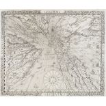
Franciscus Ritter, German c.1570-1644- Sundial Map of the World, 1640; engraving, 29.6x36.5cm (
Franciscus Ritter, German c.1570-1644- Sundial Map of the World, 1640; engraving, 29.6x36.5cm (unframed)Refer to department for condition report
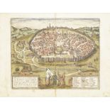
Franz Hogenberg, German 1535-1590, Georg Braun, German 1541-1622- Hierosolyma, Urbs Sancta.
Franz Hogenberg, German 1535-1590, Georg Braun, German 1541-1622- Hierosolyma, Urbs Sancta. Ludeae, Totiusque Orientis Longe Clarissima, Qua Ampl...
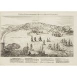
Emanuel Van Meteren, Flemish 1535-1612- Warhafftige Abbildung von Einnehmung der Statt S. Salvator
Emanuel Van Meteren, Flemish 1535-1612- Warhafftige Abbildung von Einnehmung der Statt S. Salvator in der Baya de Todos los Santos, c.1634; engrav...
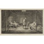
After John Webber RA, British 1752-1793- The Inside of a Winter Habitation in Kamtschatka; copper
After John Webber RA, British 1752-1793- The Inside of a Winter Habitation in Kamtschatka; copper engraving on laid by William Sharp, from Captain...
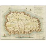
Lieutenant R P Read, British, late 18th/early 19th century- Geographical Plan of the Island of Saint
Lieutenant R P Read, British, late 18th/early 19th century- Geographical Plan of the Island of Saint Helena, 1815; linen-mounted map with Napoleon...