Perfeziona la tua ricerca
Filtered by:
- Sale Section,
- Categoria
5 items
- Elenco
- Grid
Questo banditore ha scelto di non pubblicare i risultati. Contattalo direttamente per qualsiasi domanda.
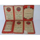

Six Ordnance Survey maps inc London, Greater London, East Kent and Eastbourne.
Lotto 156
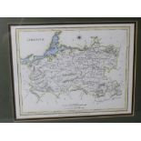
A hand coloured reproduction map of Limerick, Ireland, from Lewis' Topographical Dictionary,
A hand coloured reproduction map of Limerick, Ireland, from Lewis' Topographical Dictionary, framed and mounted, sight size 24 x 19cm, overall siz...
Lotto 174
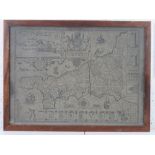
Map; Cornwall, published by John Speed, discoloured and a/f (cracking to right of centre),
Map; Cornwall, published by John Speed, discoloured and a/f (cracking to right of centre), framed and in good heavily glazed frame, overall 54 x 4...
Lotto 180
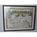
A contemporary print of a Berkshire map dated 1350, framed and glazed, overall size 61 x 49cm.
A contemporary print of a Berkshire map dated 1350, framed and glazed, overall size 61 x 49cm.
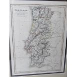
A hand coloured map of Portugal published by C Smith 172 Strand, engraved for Smith Atlas by Pickett, marked in pencil lower middle C.1820, in con...