Filtered by:
- Categoria
3 items
- Elenco
- Grid
A subscription to the Price Guide is required to view results for auctions ten days or older. Click here for more information

Lotto 289
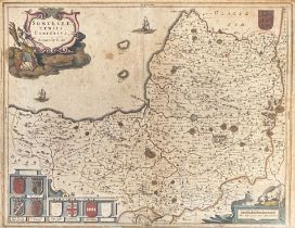
Joan Blaeu (1596-1673), A 17th century hand coloured map of Somerset, 'Somersetshire: Tensis
Joan Blaeu (1596-1673), A 17th century hand coloured map of Somerset, 'Somersetshire: Tensis Comitatus', c.1648, 39x52cm
Lotto 290
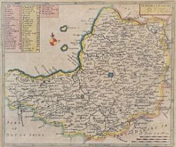
Robert Morden, a small 18th century map of Somerset, 18x21cm; together with a small map of
Robert Morden, a small 18th century map of Somerset, 18x21cm; together with a small map of Dorsetshire engraved by Toms after Badslade, 16x17cm
Lotto 291
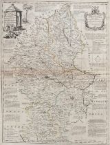
Emmanuel Bowen, an 18th century 'An improved map of the County of Stafford', printed for Carington
Emmanuel Bowen, an 18th century 'An improved map of the County of Stafford', printed for Carington Bowles, c.1762, 70x54cm