Filtered by:
- Categoria
- Elenco
- Grid
A subscription to the Price Guide is required to view results for auctions ten days or older. Click here for more information
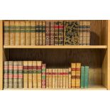

Gibbon (Edward) - The History of the Decline and Fall of the Roman Empire, 12 vol. in 6, engraved portrait and one folding map only (of 2, both ...
A Collection of Theological Tracts , 6 vol (Richard, Bishop of Landaff ) A Collection of Theological Tracts , 6 vol., engraved map frontis...
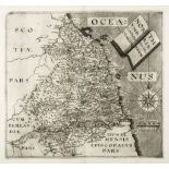
Dorsetshire.- Speed (John) - Dorsetshyre, inset plan of Dorchester upper left, strapwork title
Dorsetshire.- Speed (John) - Dorsetshyre, inset plan of Dorchester upper left, strapwork title cartouche upper right, coats-of-arms, ships and sea...
A small mixed group of English county maps, comprising Cornwall by Robert Morden for 'New Description and State of England', 1701; Northumbriæ Com...
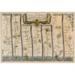
Ogilby (John) - The Road from London to Southampton; The Road from London to Newhaven com.
Ogilby (John) - The Road from London to Southampton; The Road from London to Newhaven com. Sussex; The Roads from Chelsmford in Essex to Maldon, ...
Ireland.- Taylor (George) and Andrew Skinner. - Taylor and Skinner's Maps of the Roads of Ireland, surveyed 1777 , large folding engraved map ...
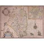
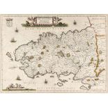
-. Speed (John) - The Countie of Leinster with the citie Dublin Described, inset plan of Dublin
-. Speed (John) - The Countie of Leinster with the citie Dublin Described, inset plan of Dublin upper right, strapwork title cartouche upper left,...
Leicestershire.- Burton (William) - The Description of Leicester Shire Containing Matters of
Leicestershire.- Burton (William) - The Description of Leicester Shire Containing Matters of Antiquitye, Historye, Armorye, and Genealogy, portr...
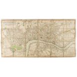
Laurie (Robert) and James Whittle. - A New & Complete Plan of London, Westminster, & Borough of
Laurie (Robert) and James Whittle. - A New & Complete Plan of London, Westminster, & Borough of Southwark, containing all the Improvements In, an...
Maps.- Mogg (Edward) - London in Miniature, with the Surrounding Villages, engraved map with
WITHDRAWN Maps.- Mogg (Edward) - London in Miniature, with the Surrounding Villages, engraved map with original hand-colouring, 535 x 950mm., diss...
Norfolk.- Hollar (Wenceslaus) - The Mappe of Norfolke, Suffolke, Cambridgeshire ..., engraved
Norfolk.- Hollar (Wenceslaus) - The Mappe of Norfolke, Suffolke, Cambridgeshire ..., engraved map, outline colour, 410 x 510mm, 1644 or later; ...
Suffolk.- [Cromwell (T.K.)] - Excursions in the County of Suffolk, 2 vol., folding map, folding
Suffolk.- [Cromwell (T.K.)] - Excursions in the County of Suffolk, 2 vol., folding map, folding plan, 2 extra engraved titles, 96 plates, re-cas...
Hinderwell (Thomas) - The History and Antiquities of Scarborough and the Vicinity, engraved
Hinderwell (Thomas) - The History and Antiquities of Scarborough and the Vicinity, engraved frontispieces, folding plan, map & 3 plates, marked...
Ordnance Survey, - No. XCIII, part of Yorkshire, map, one inch to the mile, hand-coloured,
Ordnance Survey, - No. XCIII, part of Yorkshire, map, one inch to the mile, hand-coloured, dissected and mounted on linen, morocco slip-case, gi...
A mixed group of small maps of the continent, by or after Porro, Ortelius, van den Keere, Vrints,
A mixed group of small maps of the continent, by or after Porro, Ortelius, van den Keere, Vrints, Morden, Bion, and Mercator, engraved maps, som...
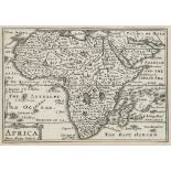
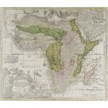
Boulton (Solomon) - Africa, with All Its States, Kingdoms, Republic,s Regions, Islands, &c., wall
Boulton (Solomon) - Africa, with All Its States, Kingdoms, Republic,s Regions, Islands, &c., wall map of the continent, large title cartouche with...
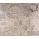
De l'Isle (Guillaume) - Carte d’Afrique, the continent of Africa, with the coast of Brazil, southern
De l'Isle (Guillaume) - Carte d’Afrique, the continent of Africa, with the coast of Brazil, southern Europe and the Middle East, decorative title ...
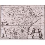
Merian (Matthaeus) - Æthiopia Superior vel Interior vulgo Abissinorum sive Presbiteri Ioannis
Merian (Matthaeus) - Æthiopia Superior vel Interior vulgo Abissinorum sive Presbiteri Ioannis Imperium, central Africa with title cartouche suppor...
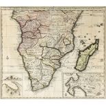
Moll (Herman) - The South Part of Africa and the Island of Madagascar, engraved map with original
Moll (Herman) - The South Part of Africa and the Island of Madagascar, engraved map with original hand-colouirng in outline, 210 x 280mm., c.17...
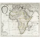
Seutter (Matthaeus) - Africa iuxta Navigationes et Observationes.., the continent, with decorative
Seutter (Matthaeus) - Africa iuxta Navigationes et Observationes.., the continent, with decorative vignette title of animals, mythological creatur...
Visscher (Nicolaes) - Carte de l'Afrique Meridionale, ou Pays entre la ligne & Le Cap de Bonne
Visscher (Nicolaes) - Carte de l'Afrique Meridionale, ou Pays entre la ligne & Le Cap de Bonne Esperance, et l'Isle de Madagascar, southern Afr...
Jansson (Jan) - Virginiæ partis australis, et Floridæ partis orientalis, from Le Nouveau Theatre
Jansson (Jan) - Virginiæ partis australis, et Floridæ partis orientalis, from Le Nouveau Theatre de la Monde, the eastern seaboard of North Americ...
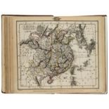
publisher. The Scripture Atlas; or, a Series of Maps, additional engraved title publisher. The
publisher. The Scripture Atlas; or, a Series of Maps, additional engraved title publisher. The Scripture Atlas ; or, a Series of Maps, additi...
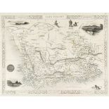
-. Walker (J. & E., & Co.) - A New Modern General Atlas, containing Thirty-Four Distinct Maps,
-. Walker (J. & E., & Co.) - A New Modern General Atlas, containing Thirty-Four Distinct Maps, title, descriptive index and 34 engraved double-pa...
A mixed group of small and miniature maps of Normandy and Britanny, by or after Ortelius, Bertius,
A mixed group of small and miniature maps of Normandy and Britanny, by or after Ortelius, Bertius, Mercator, Jansson, and Pazzini, 7 engraved ma...
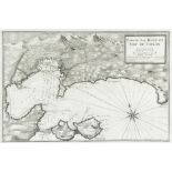
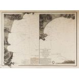
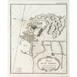
Ayrouard (Jacques) - A group of 4 coastal charts for Recueil de plusiers plans des Ports Méditerran,
Ayrouard (Jacques) - A group of 4 coastal charts for Recueil de plusiers plans des Ports Méditerran, including Plan du Golfe et des Caps de St Tro...
Blaeu (Willem) - Normandia Ducatus; Britannia Ducatus, 2 regional maps of Normandy and Britanny,
Blaeu (Willem) - Normandia Ducatus; Britannia Ducatus, 2 regional maps of Normandy and Britanny, each with title banderole supported by putti and ...
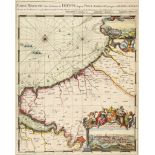
Hooghe (Romain de) - Carte Maritime des Environs de Dieppe depuis Pont Asselane jusque au Havre de
Hooghe (Romain de) - Carte Maritime des Environs de Dieppe depuis Pont Asselane jusque au Havre de Grace, coastal chart with inset views of Dieppe...
Robert de Vaugondy (Gilles & Didier) - Partie Septentrionale du Gouvernem. General de Champagne,
Robert de Vaugondy (Gilles & Didier) - Partie Septentrionale du Gouvernem. General de Champagne, regional map with decorative grapevine title cart...
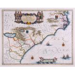
Sanson (Nicolas) - Le Comté et Gouvernement de Provence, regional map of southern France, decorative
Sanson (Nicolas) - Le Comté et Gouvernement de Provence, regional map of southern France, decorative title cartouche of flags and arms, lower righ...
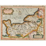
Zatta (Antonio) - Li Governi del Delfinato e di Provenza, regional map of southern France with rural
Zatta (Antonio) - Li Governi del Delfinato e di Provenza, regional map of southern France with rural landscape title vignette upper right, engrav...
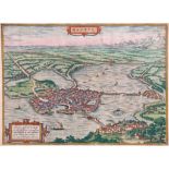
Braun (Georg) and Franz Hogenberg. - Mantua, bird s-eye plan/view of Mantua and its hinterland, with
Braun (Georg) and Franz Hogenberg. - Mantua, bird s-eye plan/view of Mantua and its hinterland, with strapwork cartouches upper centre and lower l...
Homann (Heirs of) - Palaestina in XII. Tribus divisa, decorative Latin title cartouche with vignette
Homann (Heirs of) - Palaestina in XII. Tribus divisa, decorative Latin title cartouche with vignette encampment scene lower right, French title in...
Barrow (John) - Mountain Ascents in Cumberland and Westmorland, folding engraved map, some foxing
Barrow (John) - Mountain Ascents in Cumberland and Westmorland, folding engraved map, some foxing and marginal soiling, several ink annoations, m...
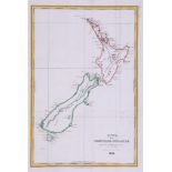
New Zealand.- Tardieu (Ambroise) - Carte de la Nouvelle-Zélande, for Dumont D'Urville's Voyage
New Zealand.- Tardieu (Ambroise) - Carte de la Nouvelle-Zélande, for Dumont D'Urville's Voyage Pittoresque autour du Monde, engraved map with ha...
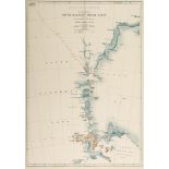
Mawson (Douglas) - British Antarctic Expedition, 1907, Route and Surveys of the South Magnetic Polar
Mawson (Douglas) - British Antarctic Expedition, 1907, Route and Surveys of the South Magnetic Polar Party 1908 - 09, chromolithograph map showin...
The Voyage of the 'Discovery', 2 vol., 2 folding maps in pockets at end ( Captain Robert Falcon)
The Voyage of the 'Discovery', 2 vol., 2 folding maps in pockets at end ( Captain Robert Falcon) The Voyage of the 'Discovery' , 2 vol., ...
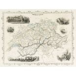
Switzerland.- - A small mixed group of maps, including Suisse or Switzerland, by Herman Moll,
Switzerland.- - A small mixed group of maps, including Suisse or Switzerland, by Herman Moll, Parte Orientale dell'Elvezia, by Antonio Zatta, Les ...
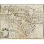
Senex (John) - A Map of Turky, Arabia and Persia, a revision of Guillaume De l'Isle's map, extending
Senex (John) - A Map of Turky, Arabia and Persia, a revision of Guillaume De l'Isle's map, extending from the Bay of Biscay to the Mogul Empire, a...
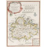
West Indies.- - A small mixed group of maps, comprising Jamaica from the Latest Surveys, by Thomas
West Indies.- - A small mixed group of maps, comprising Jamaica from the Latest Surveys, by Thomas Jefferys; A New and Accurate Map of the Island ...
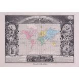
Levasseur (Victor) - set of the world and 6 continents, including Amérique Septentrionale showing
Levasseur (Victor) - set of the world and 6 continents, including Amérique Septentrionale showing Texas as an independent republic, Planisphère on...
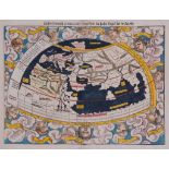
Munster (Sebastian) - Ptolemaisch general tafel begreissend die Halbe Kugel der Weldt, ptolemaic
Munster (Sebastian) - Ptolemaisch general tafel begreissend die Halbe Kugel der Weldt, ptolemaic world map with 12 windheads, from the Cosmographi...
Forshaw (Joseph M.) - Parrots of the World, Melbourne , 1973 § Hyman (Susan) Edward Lear's
Forshaw (Joseph M.) - Parrots of the World, Melbourne , 1973 § Hyman (Susan) Edward Lear's Birds, 1980, original cloth, dust-jackets ; and 10...
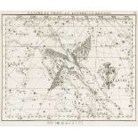
Flamsteed (John) - A group of 27 charts for the Atlas Céleste, numbered plates with French titles
Flamsteed (John) - A group of 27 charts for the Atlas Céleste, numbered plates with French titles above, engraved charts, each c.190 x 235mm., e...