

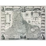
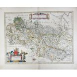
J Blaeu, hand coloured map of Norfolk, c1650. 38cm x 50cm, framed and glazed.
*
24 item(s)
Filtered by:
- Creator / Brand
- List
- Grid
-
24 item(s)/page
![[DEVON] BLAEU, Joan.](https://portal-images.azureedge.net/auctions-2024/bearne10150/images/9bf08fd8-a4c6-4b36-a926-b15000fc8d1a.jpg?w=155&h=155)
Lot 330
[DEVON] BLAEU, Joan.
[DEVON] BLAEU, Joan. Devonia vulgo Devon-Shire, hand coloured map, 1645 or later, latin text, f&g, 40cm x 52cm; together with MORDEN, Robert. Devo...

Lot 415
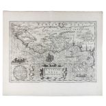
WILLEM JANSSON BLAEU (1571 - 1638): 17th century (c1635) engraved coloured map of Lake Geneva
WILLEM JANSSON BLAEU (1571 - 1638): 17th century (c1635) engraved coloured map of Lake Geneva after J Coulart from an early edition of Blaeu's ATL...
![[Blaeu (J.)], Ducatus Eboracensis Anglice York Shire, no date [c. 1648 or later], hand-coloured](https://portal-images.azureedge.net/auctions-2024/srten11154/images/eeadb595-4db1-4b69-9665-b16100bf9808.jpg?w=155&h=155)
Lot 1224
[Blaeu (J.)], Ducatus Eboracensis Anglice York Shire, no date [c. 1648 or later], hand-coloured
[Blaeu (J.)], Ducatus Eboracensis Anglice York Shire, no date [c. 1648 or later], hand-coloured engraved map, latin text verso, mounted, framed a...
LOW COUNTRIES -- "BELGIUM, Sive Inferior Germania post omnes in hac forma, exactissimè descripta auct. Abrahamo Goos". Amst., J. Janssonius, 1631....
SPAIN -- "VALENTIA REGNUM (…)". Amst., G. Blaeu, (1635). Handcold. engr. map w. compass rose, sea monster, ships in full sea and cartouche. 385 x ...
Lot 334
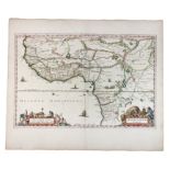
BLAEU, Willem Janszoon.
BLAEU, Willem Janszoon. [MOROCCO] Fezzae et Marocchi Regna Africae celeberrima, described at Abrah: Ortelius, hand coloured map, Amsterdam c.1640,...

Johannes Blaeu: 17th century hand tinted engraved map of Essex, plate 43 x 52cm, glazed frame

Johannes Blaeu - 17th century hand-coloured county map of Norfolk, 'Nortfolcia / Norfolke', with typewritten label verso stating 'J. Blaeu c. 166...
AFRICA -- "GUINEAE NOVA DESCRIPTIO". (Amst., Mercator/Hondius, c. 1638). Plain engr. map w. 2 cartouches and 2 ships. 342 x 480 mm. -- "AETHIOPIA ...
LOW COUNTRIES -- "HOLLANDIA COMITATUS". (Amst.), W. Blaeu, n.d. (=1647/-48). Engr. map w. some colouring. 395 x 525 mm. Dutch text on v°. (Rather ...

Johannes Blaeu: 17th century hand tinted engraved map of Suffolk, with German text verso, 38 x 49cm, glazed frame

EASTERN EUROPE -- "HUNGARIA REGNUM". Amst., G. & J. Blaeu, (c. 1650). Handcold. engr. map. 420 x 510 mm. -- Added: "MARCHIONATUS MISNIAE una cum V...
Lot 947
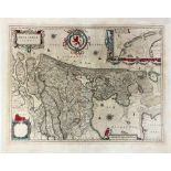
GREAT BRITAIN -- "MONUMETHENSIS COMITATUS. Vernacule Monmouth Shire". - "RUTLANDIA COMITATUS. Rutlan
GREAT BRITAIN -- "MONUMETHENSIS COMITATUS. Vernacule Monmouth Shire". - "RUTLANDIA COMITATUS. Rutland Shire". - (Amst., J. Blaeu, c. 1568-62). 2 e...
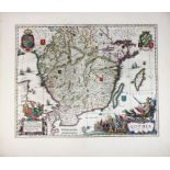
SWEDEN -- "GOTHIA". (Amst.), J. Blaeu, (c. 1650). Cont. handcold. engr. map by A. Bareo with richly dec. cartouche and coat of arms. 420 x 530 mm....

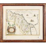
Johannes Blaeu - 17th century hand-coloured county map of Somerset, 'Somersettensis Comitatus / Somerset Shire', with typewritten label verso stat...
BELGIUM -- "LEODIENSIS DIOECESIS". Amst., W. & J. Blaeu, (c. 1643). Handcold. engr. map. 380 x 495 mm. (Split on fold in lower margin). -- "PRIMA ...

Lot 942
FRANCE -- "ARCHIESCOPATUS CAMERACENSIS / Archevesché Cambray". Amst., W. Blaeu, (c. 1660). Handcold.
FRANCE -- "ARCHIESCOPATUS CAMERACENSIS / Archevesché Cambray". Amst., W. Blaeu, (c. 1660). Handcold. engr. map. 380 x 500 mm. (Margins a bit fraye...
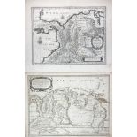
SOUTH AMERICA -- "TERRA FIRMA et Novum Regnum Granatense et Popayan". Amst., W. Blaeu, (c. 1635). 378 x 490 mm. (Latin text on v°). (Some creases/...
Lot 971
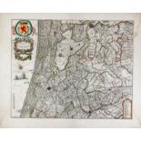
LOW COUNTRIES -- "RHENOLANDIÆ et AMSTELLANDIÆ exactissima Tabula". (Amst.,) G. Blaeu. (c. 1645
LOW COUNTRIES -- "RHENOLANDIÆ et AMSTELLANDIÆ exactissima Tabula". (Amst.,) G. Blaeu. (c. 1645). Partly handcold. engr. map. 408 x 502 mm. (Paper ...
AFRICA -- "NIGRITARUM REGIO". (Amst.), J. Blaeu, (c. 1670). Handcold. engr. map, w. 2 cartouches. 380 x 570 mm. (Sl. browned, split on fold in upp...

SOUTH AMERICA -- "TERRA FIRMA et Novum Regnum Granatense et Popayan". Amst., W. Blaeu, (c. 1645). Handcold. engr. map w. 2 cartouches and 2 compas...

Lot 485
Asien - Indonesien -
Asien - Indonesien - - Molluken. "Moluccae Insulae celeberrimae". Mit altem Grenz- und Flächenkolorit, Kupferstichkarte, G. Blaeu in Amsterdam,...

Lot 393
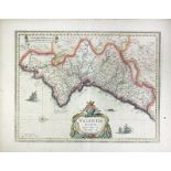
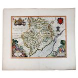
Blaeu's Map of Berkshire,
Blaeu's Map of Berkshire, circa 1645, in Dutch, later coloured, 38cm x 51cm, framed and glazed