No Image Lot 276 A 19th century hand coloured Cornish mining print "Digging for Tin Under the Sea in Cornwall" after 276A 19th century hand coloured Cornish mining print "Digging for Tin Under the Sea in Cornwall" after Truro Auction Centre A 19th century hand coloured Cornish mining print "Digging for Tin Under the Sea in Cornwall" after Harold Oakley, the footnote details "This Diag... Add to watchlist Live
No Image Lot 549 A selection of Indian related engravings and maps including "Plan of the Cantonment of Ootacamund 549A selection of Indian related engravings and maps including "Plan of the Cantonment of Ootacamund Truro Auction Centre A selection of Indian related engravings and maps including "Plan of the Cantonment of Ootacamund 1841"; pen and ink sketch of a balcony scene; a ... Add to watchlist Live
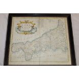
No Image Lot 537 A 17th century hand coloured map of Cornwall by Robert Morden, 537A 17th century hand coloured map of Cornwall by Robert Morden, Truro Auction Centre A 17th century hand coloured map of Cornwall by Robert Morden, framed and glazed Add to watchlist Live
No Image Lot 204 A Kelly's Directory of Devon and Cornwall with maps 1926 and Kelly's Directory of Cornwall 1939 (20 204A Kelly's Directory of Devon and Cornwall with maps 1926 and Kelly's Directory of Cornwall 1939 (20 Truro Auction Centre A Kelly's Directory of Devon and Cornwall with maps 1926 and Kelly's Directory of Cornwall 1939 (20 Add to watchlist Live
No Image Lot 29 A 19th century black and white engraving of Porthleven Harbour with dedication and map for Messrs. 29A 19th century black and white engraving of Porthleven Harbour with dedication and map for Messrs. Truro Auction Centre A 19th century black and white engraving of Porthleven Harbour with dedication and map for Messrs. Harvey & Co. of Hayle and Porthleven Add to watchlist Live
No Image Lot 178 A handcoloured map of Helstone, two handcoloured maps of field boundaries in the Helston area, 178A handcoloured map of Helstone, two handcoloured maps of field boundaries in the Helston area, Truro Auction Centre A handcoloured map of Helstone, two handcoloured maps of field boundaries in the Helston area, a copy map of the River Fal, various Helston relat... Add to watchlist Live
No Image Lot 637 A** J** H** - acrylic "Autumn Colours on St. 637A** J** H** - acrylic "Autumn Colours on St. Truro Auction Centre A** J** H** - acrylic "Autumn Colours on St. Martin's, Isles of Scilly", inscribed and dated 2021, 12" x 15½" Add to watchlist Live
No Image Lot 278 An 1831 hand coloured map of Helston showing the boundaries of the Old Borough after R. K. 278An 1831 hand coloured map of Helston showing the boundaries of the Old Borough after R. K. Truro Auction Centre An 1831 hand coloured map of Helston showing the boundaries of the Old Borough after R. K. Dunstan, framed and glazed Add to watchlist Live
No Image Lot 643 A 17th century hand coloured map of Huntingdon by William Kip, 643A 17th century hand coloured map of Huntingdon by William Kip, Truro Auction Centre A 17th century hand coloured map of Huntingdon by William Kip, framed and glazed Add to watchlist Live
No Image Lot 413 Larn (R & B) Shipwreck Index of the British Isles - vol. 413Larn (R & B) Shipwreck Index of the British Isles - vol. Truro Auction Centre Larn (R & B) Shipwreck Index of the British Isles - vol. 1 Isles of Scilly, Cornwall, Devon and Dorset, 1 vol. signed by the authors and dedicated... Add to watchlist Live
No Image Lot 604 An 18th century hand-coloured map of Monmouth after Robert Morden 604An 18th century hand-coloured map of Monmouth after Robert Morden Truro Auction Centre An 18th century hand-coloured map of Monmouth after Robert Morden Add to watchlist Live
No Image Lot 615 An 18th century hand coloured map of Shropshire by E. Bowen and one other Shropshire map by J. 615An 18th century hand coloured map of Shropshire by E. Bowen and one other Shropshire map by J. Truro Auction Centre An 18th century hand coloured map of Shropshire by E. Bowen and one other Shropshire map by J. Cary (2) Add to watchlist Live
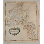
No Image Lot 605 An 18th century hand-coloured map of Oxfordshire after Robert Morden 605An 18th century hand-coloured map of Oxfordshire after Robert Morden Truro Auction Centre An 18th century hand-coloured map of Oxfordshire after Robert Morden Add to watchlist Live
No Image Lot 510 An early 19th century map of the World published by Brightly & Kimersley 1807 and one other early 510An early 19th century map of the World published by Brightly & Kimersley 1807 and one other early Truro Auction Centre An early 19th century map of the World published by Brightly & Kimersley 1807 and one other early map of Germany (2) Add to watchlist Live